JJBASHB
-
Posts
855 -
Joined
-
Last visited
About JJBASHB

- Birthday 11/09/1987
Recent Profile Visitors
7,292 profile views


-
Don’t want to get too far off topic (spoiler I did, skip now if you hate this stuff) but I agree skepticism is valuable, the backbone of science, but like any tool can be used to mislead or misapplied. Productive AGW debate lives in the averages, not in the extremes, trying to link a single extreme event seems like it will fail from the onset based on the required burden of scientific proof. But at the same time it’s equally as disingenuous to point at those people and question the whole notion. You’re always going to have weenies reporting erroneous snow reports from Lunenburg that tack on 4 extra inches. Who doesn’t love 4 more inches… of snow. Or a 133 HI in New Jersey. Or sensor errors. Or changes in local environment. All of which make comparing specific information today to the past difficult, and merit discussion, but not throwing the baby out with the bathwater. The use of end of the world narrative is similar in my opinion, the goal is to avoid a measured middle ground. There’s a lot of middle ground between it doesn’t matter and end of the world. Impacts could be gradual compared to an individual’s timeline, but time is relative. If a coastal area of millions and its associated infrastructure slowly becomes uninhabitable in a century, that’s a big deal, but not for everyone living now. That scenario still causes a significant amount of disruption and potential suffering. Discussions on how to prepare/ advances in the ability to quickly establish/increase infrastructure in the event of mass migration are still fruitful. This is just one aspect, crop failures, ecosystem disruption, etc. There is potential for suffering, stagnating or reversing/wiping out growth through all of these events without it being the end of civilization. There are lots of examples through history, too, of near total and local scale civilization collapse. It’s part of reality. Could focusing the discussion on how end of the world calls are absurd/fear mongering, instead of what can be done about the million other possibilities, be a ploy to polarize to the point nothing is done outside of elite circles? Which is the radical flip side of skepticism, deliberate paralyzing the masses through skepticism/narrative overload/polarization so nature takes its course outside of special enclaves. Anyway, way off topic and descended into movie plot territory. Going back to lurking/waiting for another 6/1/11, enjoying the last of the heat, and tracking the upcoming heavy rain potential. Happy 4th!
-
I actually see it as purposefully using bad data, not to support climate change, but to discredit it. The point isn’t to cause fear or anxiety, the point is to cause skepticism through intentionally flawed/exaggerated statements. It takes the narrative away from the event, makes it seem like it’s agenda/hype driven, and takes away from legitimate discussion. The dupe isn’t getting you to think everything extreme, the dupe is making everyone overly skeptical so it’s okay to buy into whatever you choose to believe regardless of fact. It’s like dressing up like a clown before having a serious discussion. You aren’t trying to be taken seriously, you’re trying to get people to think that those who hold the position are clowns.
-
The funny thing is the snow map would look exactly the same in January.
-
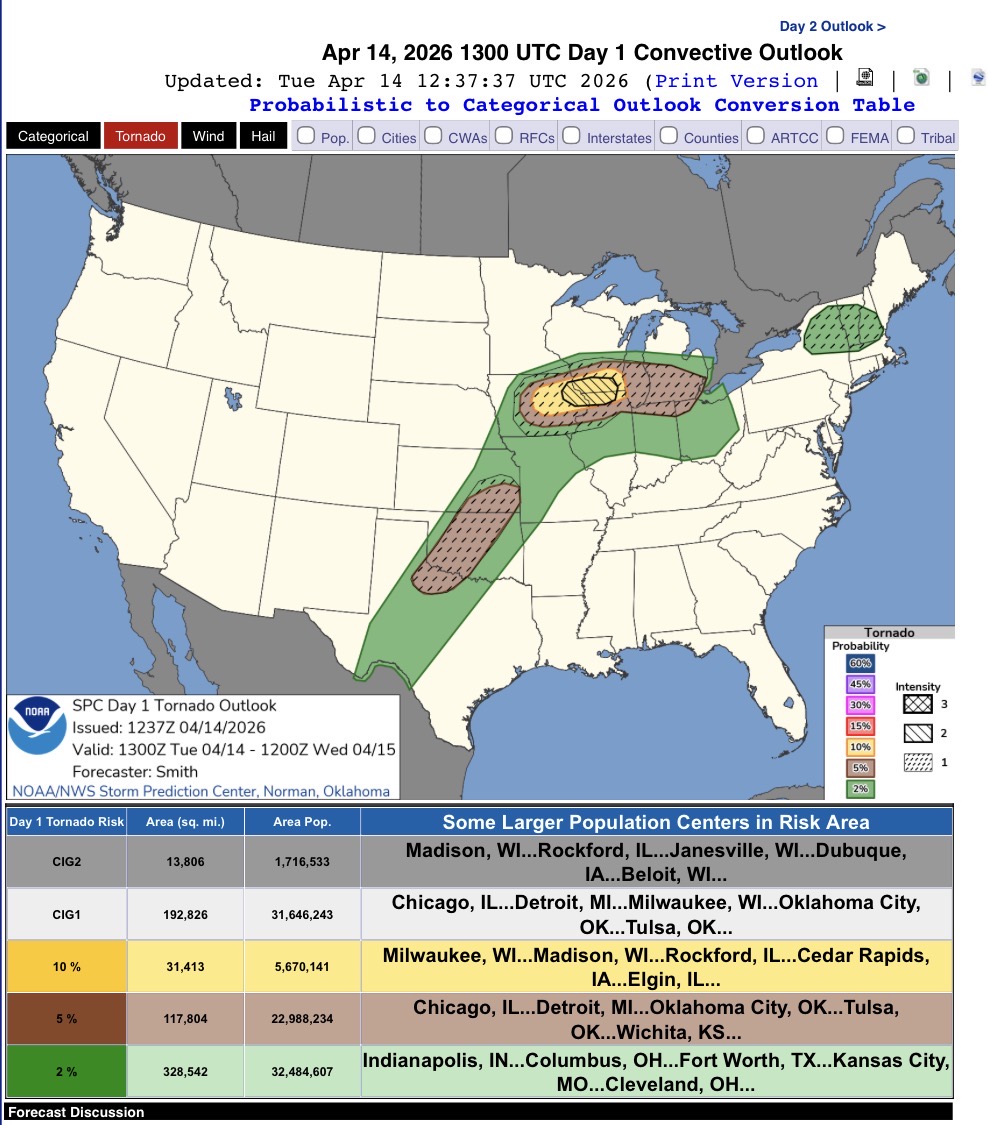
2% Tornado ...Northeast... A low-amplitude disturbance associated with an ongoing MCS near Lake Ontario this morning will move east into the Northeast during the day. Cloud breaks and low-level warm/moist advection will contribute to a destabilizing airmass by midday. Veering and strengthening winds with height will support storm organization, including the potential for supercells. Eventually a band of storms is forecast to evolve by mid-late afternoon with wind damage being the primary risk. Have introduced low hail/tornado probabilities to account for hazards associated with supercells.
-
First slight risk!
-
Sun!!!
-
We got a bit more over by the Bedford line, around 1.75” total. Sleet with a layer of snow on top.
-
Kinda looks like the sleet line is headed northeast again on CC? Heavy sleet in my part of MHT.
-
Sleet line has made it to MHT. Not an official measurement but ~4” before the change.
-
One of the few situations where MHT might be the envy of New England. Up to 37. Lots of dripping but mostly sun related as the dp is still in the teens. Kind of a perfect day to get outside. Not too wet from melting but the sun feels great.
-
Clipper Fires In Wednesday Feb 25 Disco/ Obs
JJBASHB replied to Damage In Tolland's topic in New England
Definitely was generous with my eye measurement earlier. Only an 1” in Manchester -
Clipper Fires In Wednesday Feb 25 Disco/ Obs
JJBASHB replied to Damage In Tolland's topic in New England
-SN bordering on SN despite the progressive radar. It’s like the snow form of misery mist. Lots of tiny flakes. Looks like 1.5” -
Clipper Fires In Wednesday Feb 25 Disco/ Obs
JJBASHB replied to Damage In Tolland's topic in New England
Steady light snow, surfaces disappearing fast. -
Clipper Fires In Wednesday Feb 25 Disco/ Obs
JJBASHB replied to Damage In Tolland's topic in New England
First flakes. -
Clipper Fires In Wednesday Feb 25 Disco/ Obs
JJBASHB replied to Damage In Tolland's topic in New England
Virga despite the heavier echos overhead.