SBUWX23
-
Posts
1,292 -
Joined
-
Last visited
Content Type
Profiles
Blogs
Forums
American Weather
Media Demo
Store
Gallery
Everything posted by SBUWX23
-
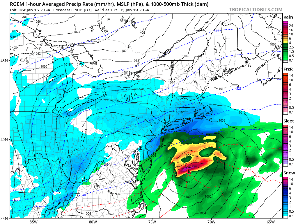
 Clown map from the 18z rgem. Continues to trend towards more of the inverted trough compared to a larger coastal influence
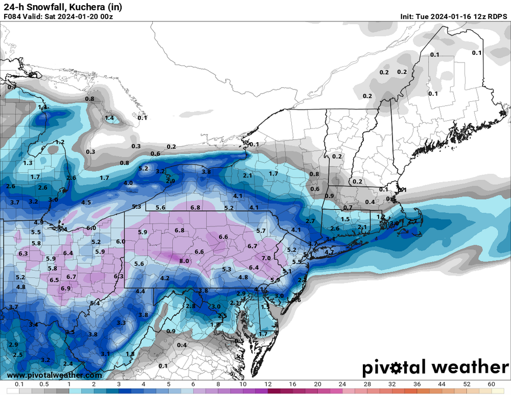
-
The one thing id consider is the sun will do some work on the sun tomorrow but there should be some snow left for sure
-
And it won't rain or mix. It shouldn't at least based on the synoptic pattern
-
Some of it I don't think is his fault. They were missing their best offense guy last playoff. They need 1 more power forward who can score. He has completely changed their culture and don't think he's gone after this year if they don't win it all
-
Euro had zilch for today about 3 days ago.
-
Updates will come early afternoon..
-
I know many are worried about the pattern change coming but we should not forget that we have not yet reached our climo highest snow month. I'm gonna be venture to say we will have chances at some point later in February
-
The forcing should be a bit better Fri if it evolves. Just concerned if it's soley the inverted trough that lots will be screwed by it. Always difficult to know where
-
Rgem isn't as good as 06z run but the 12z is at least a prolonged snow.
-
Unreliable nam at 84 seems to hint at similar.
-
Winds are still NNE. If it stays that way parts of nw LI into the city may never get above 32. But if it's around 32 any zr won't be an issue. Bigger concerns for black ice tonight though as temperatures fall.
-
The snow is not just gonna disappear. Roads will improve but you'll have snow on the ground by time it goes back below freezing
-
Yes I saw. Another problem is there is low placement issues along the potential Inverted trough. You can see that on the 84 hr nam. There is a lot of energy coming in around the PV so could be a reflection of that.
-
The good news is it's close to 32. It's self limiting during the day and with temps rising slowly it'll prevent any significant issues. It's gonna be a problem tonight though when temps crash with standing water.
-
Need to see a few more of these on other guidance as well. Yes, I have seen the ensembles and see some are closer but the large majority keeps the main low well east. Will we see a trend closer?
-
I think the calls that models and forecasters busted a premature. Off by an inch? That's simply within the realm of error when it comes to snowfall forecasting. We did pretty good on LI, now sleeting here in Yaphank area. It's always better not use snowfall maps from models as they do not account for anything other than qpf. Snowfall habit and other characteristics are never handled well by models. The other thing this ended up being a little more banded over stratiform. It wasn't necessarily dry air moreso how the forcing evolved. Enjoy the snow that's out there! And finally that ridiculous stat is broken. CPK got 1.8 in that event last February but it was over 2 calendar days. So tired of hearing about the snowless streak when it snowed, just under an inch in two back to back days
-
Im not the CMC biggest fan, but it never let go of this system tonight although it was too strong and too far inland. It never ceases to amaze me how wonky the GFS is when there a potential coastal event here thats not rain. I am still not completely sold on this one though. I know the "indices" are changing, but that PV could easily squash this thing and push it offshore like the GFS.
-
gotta take the mask off that program because this kind of snow reflects back less.
-
It would be nice if we can just enjoy the snow and not worry about freezing rain right now
-
I think the 00z nam has some feedback with convection with the low that is resulting in higher qpf out east. Not sure if I buy that
-
Dry air eroded away on schedule. Light snow falling central Suffolk County just north of the LIE.