SBUWX23
-
Posts
1,292 -
Joined
-
Last visited
Content Type
Profiles
Blogs
Forums
American Weather
Media Demo
Store
Gallery
Everything posted by SBUWX23
-

2/13 Significant/Major Winter Storm Discussion & Observations
SBUWX23 replied to Northof78's topic in New York City Metro
the hrrr has basically stopped trending south and maybe even inched the north edge up a bit. -
2/13 Significant/Major Winter Storm Discussion & Observations
SBUWX23 replied to Northof78's topic in New York City Metro
this is still a model analysis to a level using RAP fields. so dont panic off this. -
2/13 Significant/Major Winter Storm Discussion & Observations
SBUWX23 replied to Northof78's topic in New York City Metro
soon itll be a 1000 mb low. those strength changes are noise. its the precip shield that we have to watch -
2/13 Significant/Major Winter Storm Discussion & Observations
SBUWX23 replied to Northof78's topic in New York City Metro
its over. the 6-8 on a mean wont accumulate. -
2/13 Significant/Major Winter Storm Discussion & Observations
SBUWX23 replied to Northof78's topic in New York City Metro
all of a sudden the ukmet is a god? Its been trashed on here for months. -
2/13 Significant/Major Winter Storm Discussion & Observations
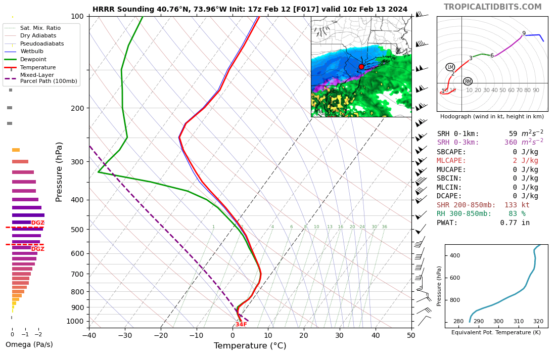
SBUWX23 replied to Northof78's topic in New York City Metro
snow likely wont be anything more than a talking point with this sounding in the city. this is 10z by the way.
-
2/13 Significant/Major Winter Storm Discussion & Observations
SBUWX23 replied to Northof78's topic in New York City Metro
So .5 to 1 inch hour will just melt everywhere? -
2/13 Significant/Major Winter Storm Discussion & Observations
SBUWX23 replied to Northof78's topic in New York City Metro
its out that far already? -
2/13 Significant/Major Winter Storm Discussion & Observations
SBUWX23 replied to Northof78's topic in New York City Metro
Holy GEFS mean -
2/13 Significant/Major Winter Storm Discussion & Observations
SBUWX23 replied to Northof78's topic in New York City Metro
There will be deformation banding, the challenge now is how large, is it multiple bands, and where do they set up and move across. The fast movement argue that many will at least see it for a time even east of higher qpf predictions -
2/13 Significant/Major Winter Storm Discussion & Observations
SBUWX23 replied to Northof78's topic in New York City Metro
the Euro likely nudges back north a bit. -
2/13 Significant/Major Winter Storm Discussion & Observations
SBUWX23 replied to Northof78's topic in New York City Metro
See March storms, early April storms, and Nov 2018. -
2/13 Significant/Major Winter Storm Discussion & Observations
SBUWX23 replied to Northof78's topic in New York City Metro
Mid LI sounding is a beaut clark at 15z on new GFS -
2/13 Significant/Major Winter Storm Discussion & Observations
SBUWX23 replied to Northof78's topic in New York City Metro
Im pretty sure nws forecast accumulation that is not on road surfaces -
2/13 Significant/Major Winter Storm Discussion & Observations
SBUWX23 replied to Northof78's topic in New York City Metro
Usually northern parts do better but in this case it may be west vs east. -
2/13 Significant/Major Winter Storm Discussion & Observations
SBUWX23 replied to Northof78's topic in New York City Metro
Especially for us on LI. It's such a fickle situation for us but we are due. -
2/13 Significant/Major Winter Storm Discussion & Observations
SBUWX23 replied to Northof78's topic in New York City Metro
There is actually good agreement now on that evolution -
2/13 Significant/Major Winter Storm Discussion & Observations
SBUWX23 replied to Northof78's topic in New York City Metro
NWS doesn't make wholesale changes this far out with things like this. They have brief updates for the very near term but not for something over 24 hours out. It's not smart to flip around so much with every cycle.Big updates will follow in a few hours. Adjustments are made in quicker times as the event is happening -
2/13 Significant/Major Winter Storm Discussion & Observations
SBUWX23 replied to Northof78's topic in New York City Metro
I was even skeptical earlier today but seeing these trends and where the mid level low ends up Tuesday morning I'm more optimistic now. Models help guide us and now things look more reasonable to expect snow down to NYC and LI Tuesday. -
2/13 Significant/Major Winter Storm Discussion & Observations
SBUWX23 replied to Northof78's topic in New York City Metro
I think people are gonna like the 00z euro. -
2/13 Significant/Major Winter Storm Discussion & Observations
SBUWX23 replied to Northof78's topic in New York City Metro
Okx briefing highlights the areas of concern. Check slide 2. https://www.weather.gov/media/okx/02112024pm_winterstorm.pdf -
2/13 Significant/Major Winter Storm Discussion & Observations
SBUWX23 replied to Northof78's topic in New York City Metro
Here we have some criticizing when forecasters flip flop and now NWS is remaining more consistent right now and some are upset and wondering why they didn't adjust. Surely if this trend continues amounts will be adjusted. -
2/13 Significant/Major Winter Storm Discussion & Observations
SBUWX23 replied to Northof78's topic in New York City Metro
High res RDPS -
2/13 Significant/Major Winter Storm Discussion & Observations
SBUWX23 replied to Northof78's topic in New York City Metro
Is that MJO? -
2/13 Significant/Major Winter Storm Discussion & Observations
SBUWX23 replied to Northof78's topic in New York City Metro
Hes sticking to his guns here and not relenting, but he needs to look lower down. there is a clear shift at 700 mb.