

andyhb
-
Posts
20,234 -
Joined
-
Last visited
Content Type
Profiles
Blogs
Forums
American Weather
Media Demo
Store
Gallery
Posts posted by andyhb
-
-
We were very close to at least partially realizing those crazy HRRR runs from Friday afternoon/evening.
-
 1
1
-
 1
1
-
-
It’s got that violent helical motion going on seen with some other big ones in the past.
-
1
-
-
Too much shear for the updrafts currently. Dewpoints not where they need to be.
-
2
-
-
Instability worse than forecast, shear better than forecast. Question is which one wins.
-
1
-
-
19 minutes ago, twistingtornado said:
Yes, PDS tornado watches can occur outside high risk. I've seen PDS tornado watches in moderate risk areas. I would be confounded if that happened today, but it's not like I'm in agreement with the SPC's products today. Definitely don't agree with their assessment of long track tornadoes from south central Missouri into Illinois. They're neglecting the wind profiles again which don't become favorable until the cells get into northeastern Missouri/Illinois. If there's a long track tornado in central to eastern Missouri, I'll eat my heart out.
Look at the VWP from DMX before deciding that.
-
2
-
-
Obs > CAMs especially on a day like this.
-
6
-
-
6 minutes ago, Chicago Storm said:
Generally agree. IA into far NE MO and far W IL is the only area that is really interesting.
However, even there you have to question the full quality of final recovery.
I mean model soundings up there are yielding moderate buoyancy even with 67/63 type T/Td pairs, which I think is achievable with the dry slot. Cold air aloft helping a lot.
-
1
-
-
Liking the IA triple point right now given the dry slot pushing in. Should see large hodographs juxtaposed with sufficient low level buoyancy for tornado potential there. The junk further south and lack of warm frontal progression really has me questioning the current moderate risk area.
-
3
-
-
All of that convection in AR and MO is probably going to have some say in whether better moisture can make it far enough north in time. Mesoscale trends aren’t exactly looking favorable for a bigger event at this time.
-
1
-
-
Big TBSS on that Jefferson City storm. Looks to be on track to impact some of the STL metro (after they already got hailed on last night).
-
27 minutes ago, StormChaser4Life said:
It's seriously embarrassing what ILX does. They always refer to SPC discussion. Like do your own analysis. DVN was uncharacteristically conservative. LOT great as always. Not sure what the other offices aren't seeing
I mean, you could always try and go work for them then.
-
1
-
 2
2
-
-
12z Euro was a bit of a downtick from earlier. Weaker wind fields/less instability.
-
1
-
-
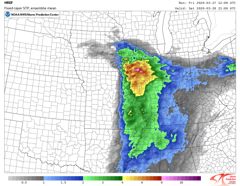
Pretty ridiculous fixed layer STP ensemble mean from the 12z HREF.
-
Synoptics here scream regional severe wx outbreak. One of the more synoptically evident events we’ve seen in recent years. Now it’s down to the mesoscale to decide on ceiling. Not every day you see a trough with a 110+ kt 500 mb max impinging on a warm sector with mid-upper 60s dewpoints regardless of season.
Wind fields seem to be gradually shifting towards more of the “these cells could be strongly tornadic” idea, but I’d also like to see what we wake up with tomorrow. I have little doubt the NAM 3 km is at least somewhat off in terms of eastward extent of the warm sector though.
-
5
-
1
-
-
Quote
Turning to Saturday`s potentially higher end severe risk, there
are some lingering uncertainties to consider. Continued strong
isentropic ascent across the warm frontal zone could keep elevated
showers and some embedded thunder threat going into the morning,
though likely less t-storm coverage than Friday night-early
Saturday. The 00z guidance continued to offer a rather classic
synoptic pattern for upper echelon severe weather potential, with
a sub 990 mb low occluding into the evening, warm front with rich
boundary layer moisture lifting northward, and an arcing Pacific
front/dryline. These surface features will be topped by extremely
impressive wind fields, including south-southwesterly 40-50+ kt
at 850 mb, southwesterly 90-100+ kt at 500 mb, and 150+ kt 250-300
mb upper level jet core, along with still steep mid- level lapse
rates.

The main uncertainties with this set-up are the northward progress
of the warm front, owing to the possibly slowing progression
east-northeastward of the surface low, threat for continued
convection (non-zero severe hail risk) north of the warm front
that could temporarily reinforce the front, and likelihood of
extensive cloud cover that hindering insolation and perhaps
destabilization. While there is overall agreement in the big
picture in the guidance, any further slowing of the warm front
and then Pac front/dry line advancing from the psuedo-triple
point could shift severe risk a bit farther west and threat into
the CWA a bit later, likely into the evening. The ECMWF and UKMET
indicated this sort of possibility. That all being said, with the
inherent uncertainties aside, the set-up has the hallmarks of a
classic midwest severe weather producer. Advection and kinematics
will play a large role in compensating for likely lacking
insolation, with advancing warm sector conditions featuring temps
around 70/low 70s, with dew points into the 60s, and
aforementioned steep lapse rates driving moderate instability
(1000-1500 j/kg MLCAPE).

The impressive wind fields will support extreme deep layer bulk
shear and favorable sufficiently orthogonal orientation to likely
support discrete or semi-discrete supercells erupting from the
Pacific front. Supercells with time to mature south of the warm
front will pose greatest risk into the CWA, with strong low level
shear (ample speed shear) and sufficient veering from southerly
at the surface to south-southwest at 850 mb for hodograph
curvature that could support tornadoes, some possibly strong,
along with large hail and damaging wind risks inherent to
supercells. Storm motions will be very fast off to the northeast,
with right moving vectors over 60 mph. At this time, do have
concerns with how far north and east into the CWA the more ominous
severe risk will be realized given aforementioned uncertainties.
However, given the available data and recent trends, placement of
SPC Day 2 Moderate Risk into the western CWA appears reasonable
given the upper level jet core intersecting the advancing low
level theta-e axis favorably in western Illinois and into north
central Illinois. ENH extending east-southeast marks possible
warm front progress uncertainty, keeping higher probabilities
south of city of Chicago for now.

Exact timing of cold front will determine how long into the
early evening higher coverage of numerous storms extends, with
severe risk then quickly ending with frontal passage. While
discussion focused on potential for slower/farther west trend with
convective initiation, certainly can`t rule out a faster outcome,
such as was depicted on the 00z HREF CAM suite. Will continue to
highlight given the range in possible outcomes, a timing of severe
threat being roughly 4-10pm.
Posting LOT’s discussion for posterity because it is a beast.
-
2
-
-
26 minutes ago, crossbowftw3 said:
The HRRR greatly oversold 5/20 so YMMV
This one is a bit different where basically every CAM is in agreement on a string of pearls ahead of that front. We have a very clear focus for initiation this time in the warm sector. I do believe the HRRR parameters may be a bit overblown in terms of instability, but its wind profiles are extremely impressive.
-
1
-
 1
1
-
-
17 minutes ago, It's Always Sunny said:
Advertising what you said above (mid-upper 60's) and yeah totally agree even a few degrees warmer can make such a difference. Still got a couple days to see how temps trend.
Every other model has temps above 70 over most of the IL warm sector at 21z.
-
19 minutes ago, It's Always Sunny said:
Lol all models are advertising here's to hoping dynamics will be able to compensate which appear impressive thus far.
Advertising warmer?
Even the GFS has temps in the low-mid 70s at 21z Saturday. Would make a big difference thermo wise, especially with seasonably high levels of moisture. If we can get the LLJ to be at least SSW by go time, that will yield shear profiles more typical with significant tornado events in this region.
-
1
-
-
Regarding the 3 km NAM, I will eat my hat if it is 65-68˚ in the warm sector at 21z Saturday. Those temps look way too low.
-
2
-
-
Storms moving at the speed of light would be number one regarding chasing. I do think there’s a pretty strong possibility this stays mostly discrete until the evening though.
Would maybe like to see a bit more turning in the lowest 3 km and a bit more instability, but I’m inclined to think that the arcing Pacific front/pseudo-dryline, in addition to the triple point in IA early on, should be a breeding ground for supercells. Tornado potential dependent on how the low level wind fields evolve (and how fast the deep layer cyclone occludes).
-
4
-
-
6 hours ago, CheeselandSkies said:
18Z HRRR sim ref/UH looks ugly for MO bootheel/southern IL/KY tomorrow, but we saw that have a tendency to overhype particularly with some of the OK setups last May. Of course, tomorrow will feature a rather different set of conditions than those did.
Why do you keep tagging me with the weenie emoji?
-
Definitely a few similarities with the setup that yielded the deadly TN tornadoes on 3/3. Strong westerly flow aloft with similar hodograph structure and I'm going to bet that the NAM/NAM 3 km are too cold at the surface. Any southerly component to the surface wind will yield large 0-1 km SRH when your 850 mb jet is 50 kts out of the WSW.
-
1
-
-
JISAO PDO is no longer being updated.
Also, the +AO has reached an all time record daily value at 6.34, surpassing 2/26/90 at 5.91.
-
Getting increasingly concerned that the strongest low-mid level FGEN and vertical ascent may set up right over the I-44 corridor in OK and N TX with this. Someone who stays cold enough is going to see 12-18”, which, for here, is crippling.
With that said, the 3 km NAM seems stubbornly persistent in its idea of really suffocating the band before anything really gets going.
April 2020 Discussion
in Lakes/Ohio Valley
Posted
Cleveland Superbomb part II in April.