

andyhb
-
Posts
20,443 -
Joined
-
Last visited
Content Type
Profiles
Blogs
Forums
American Weather
Media Demo
Store
Gallery
Posts posted by andyhb
-
-
Tornado down heading for Schaumburg @SchaumburgStormer!
-
 2
2
-
-
That is a major tornado in the middle of the Lake County burbs, that is not going to be good.
-
1
-
-
Giant tornado near Streator IL per Colin Davis. Environment near those two supercells in central IL is extreme, STP of 10, SCP of 40, 3000+ MLCAPE and 500+ ESRH.
-
1
-
-
Violent tornado in progress near Metamora IL, amazing low reflectivity debris ball.
-
4
-
-
Developing Edina MO cell looks like a candidate for a long-lived supercell. Got that kidney bean shape.
-
Via Clint Hendricks. Apparently became a large stovepipe and then a cone after this.
-
4
-
-
Very reliable report here.
-
1
-
-
Tornado in progress near Lucerne MO, TDS, report from Colin Davis.
-
1
-
-
Central/southern part of the Chicago metro is getting rocked. Seeing a lot of 80-90 mph outbound bins from KLOT not too far off the deck.
-
1
-
 1
1
-
-
The 3 km NAM has a 100 kt 500 mb max tomorrow in IA, I cannot recall very many systems at all with that in June @RCNYILWX.
-
2
-
-
Parameter space near/south of that warm front in the backed surface winds tomorrow is alarming for any semi-discrete storms that can maintain themselves in the area. While there certainly are some caveats such as storm mode, degree of HP dominance given less than ideal venting flow and high PWATs, and prior convection, the high population and potential for relatively fast moving storms makes this likely the most dangerous setup so far this year on paper.
-
2
-
-
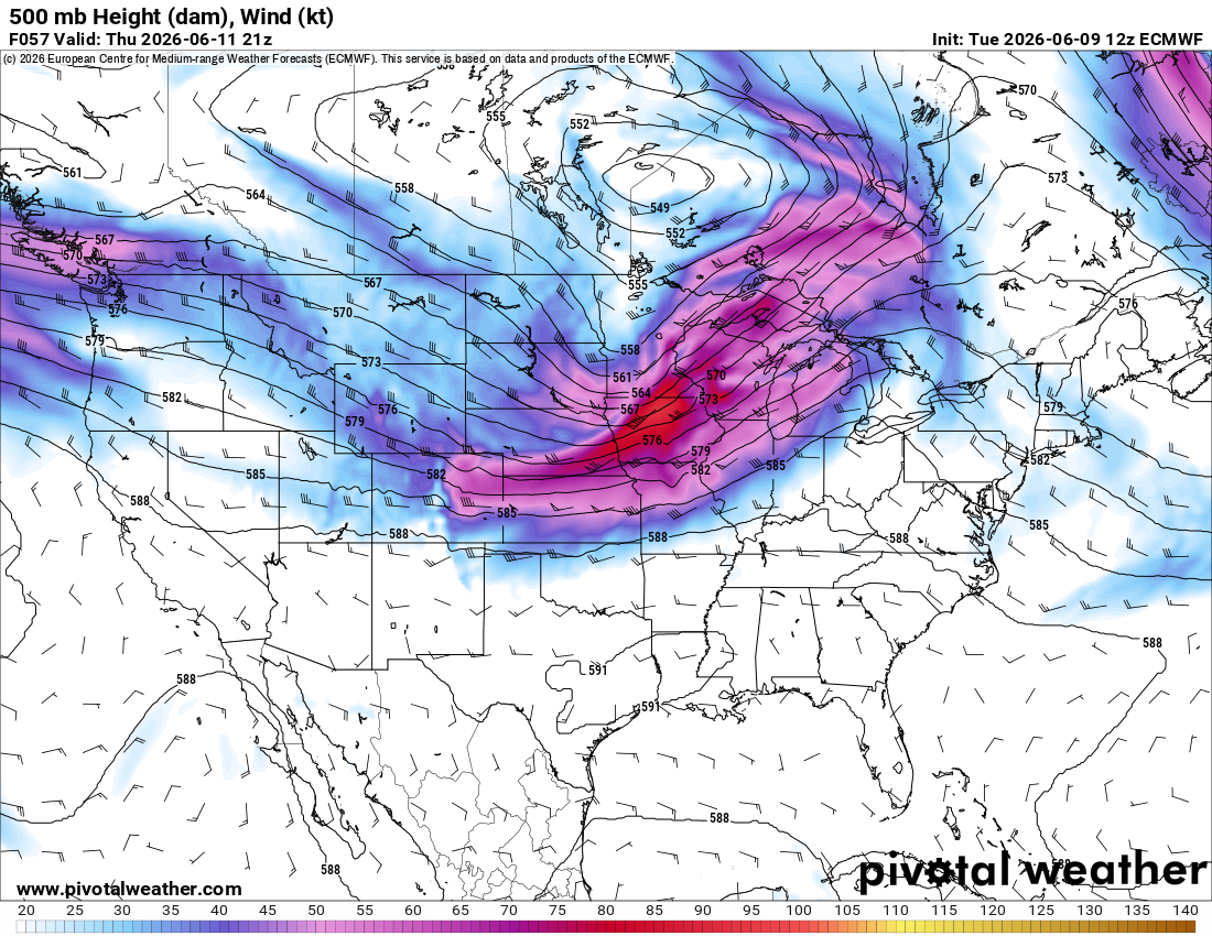
That is quite a potent shortwave on the 12z Euro for Thursday with a 90+ kt 500 mb max, especially for June. Morning convection will rule the roost as usual, but I would expect a pretty widespread and potentially significant severe event given the magnitude of the flow overlapping strong instability.

-
2
-
 1
1
-
-
PDS tornado watch out for the area surrounding the MS/OH River confluence. 80/80 tornado probabilities.
-
5
-
 1
1
-
-
Probably worth pointing out that the 12z HRRR has a) a lot of morning convection and b) what is likely a significant tornado outbreak later across E MO and W IL. The outflow restricts some of the spatial extent of the threat, but recovery occurs quickly given the strength of the wind fields.
-
Quote
   Day 3 Convective Outlook
   NWS Storm Prediction Center Norman OK
   0228 AM CDT Sat Apr 25 2026

   Valid 271200Z - 281200Z

   ...THERE IS AN ENHANCED RISK OF SEVERE THUNDERSTORMS MONDAY
   AFTERNOON AND EVENING ACROSS MUCH OF EASTERN IOWA...A PORTION OF
   SOUTHWESTERN WISCONSIN...MUCH OF EASTERN
   MISSOURI...ILLINOIS...WESTERN INDIANA...WESTERN KENTUCKY...WESTERN
   TENNESSEE...NORTHEASTERN ARKANSAS...

   ...SUMMARY...
   Widespread strong to severe thunderstorm development appears
   probable across the middle Mississippi into lower Ohio and Tennessee
   Valleys Monday afternoon and evening.  At least initially, this may
   include several evolving supercells potentially capable of producing
   strong tornadoes across parts of southeastern Iowa into central
   through southern Illinois and adjacent east central and southeast
   Missouri.

   ...Discussion...
   Models indicate that significant surface cyclogenesis will proceed
   across the Upper Midwest/adjacent Great Lakes region during this
   period, as a notable short wave perturbation and associated 50-70 kt
   cyclonic 500 mb jet streak progress northeast of the middle/lower
   Missouri Valley region.  Beneath a plume of warm/capping elevated
   mixed-layer air nosing northeastward across the middle Mississippi
   Valley, low-level warm sector moistening is generally forecast to
   contribute to moderate to strong potential instability.  Although
   the details of the potential convective evolution remain unclear,
   the environment appears likely to become supportive of organized
   severe thunderstorm development, including supercells.  Even if
   convection grows quickly upscale into one or more clusters/lines,
   embedded supercell structures will probably still pose potential for
   producing strong tornadoes.  If an initially discrete supercell mode
   is maintained for a sustained period, tornadic potential could
   maximize, with a few long track, particularly damaging tornadoes
   possible.

   At this time, it appears that strongest thunderstorm development may
   initially focus in forcing for ascent associated with
   lower/mid-tropospheric warm advection, near the nose of the
   initially capping elevated mixed-layer across parts of southeastern
   Iowa into central Illinois.  Enlarged, clockwise-curved low-level
   hodographs along this corridor, perhaps coinciding with a zone of
   stronger differential surface heating associated with a modifying
   outflow boundary, may become conducive to several strong tornadic
   supercells before convection tends to grow upscale while propagating
   southeastward into Monday evening.

   A dryline structure extending southwestward through portions of
   eastern Missouri may also support initially discrete supercell
   development, before activity tends to grow upscale ahead of an
   advancing cold front while spreading into the lower Ohio/Tennessee
   Valleys through Monday evening.

   ..Kerr.. 04/25/2026
Very strong wording in the latest D3 for Monday, got the feeling this ends up as a D2 MDT.
-
00z model guidance in so far certainly does nothing to quell concerns for Monday. Could be a widespread outbreak based on just about everything I'm seeing, and the trough/EML looks to favor discrete convection for a pretty lengthy window.
Going to need a dedicated thread for this soon.
-
5
-
-
Potential for a large scale severe weather event from the Lakes southward into the Mid South appears to be increasing for Monday (4/27, go figure) based on recent model guidance. EML looks potent across a large area with plenty of moisture, a favorable trough ejection (as of now), and strong shear across a large expanse of real estate.
-
3
-
-
17 minutes ago, pen_artist said:
@andyhb What are your thoughts on QLCS tor threat in Chicago area?
I'm not so certain there won't be a few supercells further south into N IL, although things may be a bit more mixed out down there so the tornado threat is less. Haven't looked much into the QLCS threat yet, but I'd imagine with strong shear and strong instability that it is certainly elevated.
Oh and the 18z NAM is not just bordering on a tornado outbreak in WI, it is one.
-
3
-
-
18z HRRR and 12z MPAS variants are bordering on a tornado outbreak in WI tomorrow. The former would be a huge problem for the I-94 corridor.
-
3
-
-
Tornado just went right through the middle of Clinton MO. Using this thread since it's the same system.
-
1
-
-
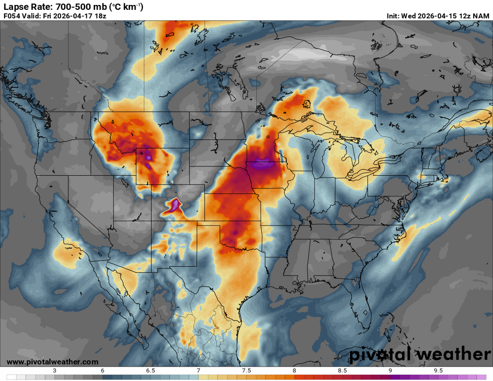
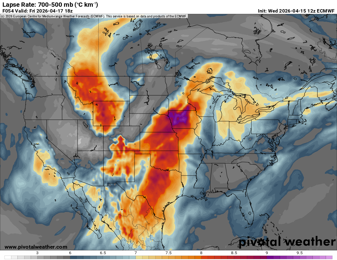
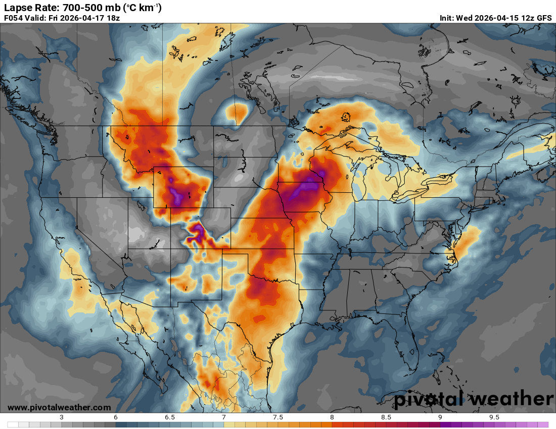
The EML on Friday morning/early afternoon is ridiculous and should raise alarm bells for anyone familiar with what is necessary to get an outbreak in the Midwest.


-
2
-
-
Friday could be a very volatile severe weather event up north in IA/WI/N IL/E MN based on what I'm seeing come off the latest guidance.
Going to almost certainly need a thread for it.
-
1
-
-

This storm has been officially rated as a Category 5 on the RSI scale for the Upper Midwest. It is the first Cat 5 for any region since Jan 2016, the first for the Midwest since GHD 2011, and it is the highest value on the RSI achieved for any region since the Jan 1996 Nor'easter.
-
6
-
 1
1
-
-
23 hours ago, weatherbo said:
Snow and wind have let up considerably with another 5-6" possible through the night. Snow is too deep to walk or even snowshoe in, there's no power, and the road is closed for miles.
Deepest snow I have ever seen. The house is almost buried..thumb.jpg.39af3485c102fc6fb55e0a06c759cdf4.jpg)
For lack of a more scientific analysis, holy shit.
-
3
-
 1
1
-

.jpg.1c946ead3f5a101df7cfae1c9acbb242.jpg)
Severe threat 6/10-6/12
in Lakes/Ohio Valley
Posted
Huge wedge tornado reported NE of Kouts per Isaac Polanski.