

andyhb
-
Posts
18,457 -
Joined
-
Last visited
Content Type
Profiles
Blogs
Forums
American Weather
Media Demo
Store
Gallery
Posts posted by andyhb
-
-
Evansville WI tornado rated prelim EF3 per Damage Assessment Toolkit. 1/7/2008 vibes.
-
 2
2
-
 2
2
-
-
2 minutes ago, CheeselandSkies said:
Just saw that on TalkWeather. Although it's actually for the timeframe valid for Thursday evening (and unfortunately, after dark this time of year).
My bad, Thursday.
-
Lol the RRFS is doing some... things in E IA/W IL tomorrow.
-
 1
1
-
-
Flying into DCA tonight and… well…
-
3 minutes ago, Chicago Storm said:
MLI is up to 14.7” and DVN is up to 13.6” as of 6PM.
Returns blossoming on KDVN again as the deformation zone starts to crank. They might pull off some huge totals.
-
5 minutes ago, beavis1729 said:
Those totals are a huge disappointment.
The warm lake destroyed two potentially great storms in one week. If the lake temps would have been anywhere close to normal, there would have been two benefits: (1) further south track/warm intrusion for each storm, like N IL often sees in the Spring when warm fronts get hung up south of the lake (2) less of a temp increase from the easterly winds. Even a 1-2 F decrease would have been huge for both storms.
Could have easily seen 20+ inches widespread across N IL this week...but instead even the best snow areas in the metro area only have 5-8" of water-laden slop on the ground.
Very unfortunate. Probably shouldn't be too upset since there's still snow on the ground and cold temps on the way...but we shouldn't have to worry about lake warmth in mid-Jan. The warm December continues to haunt us.

Welcome to a strong Nino winter in a warming climate.
-
3
-
-
Don’t want that shift to continue if you’re in N IL or you risk mixing and the dryslot.
-
1
-
-
Ope I see that title change.
-
1
-
1
-
-
1 minute ago, ILSNOW said:
18z GEFS Mean (10:1)

Reminds me quite a bit of a snow footprint with the GHD II storm in 2015.
-
1
-
-
Again, this increase across the board is nearly entirely related to the cold sector precip getting more robust.
-
5
-
-
Seems to me that some of this recent uptick in snowfall totals for those within the cold conveyor belt is an increase in coverage of the backside/deformation precipitation. One has to wonder if the general lack of convection further south may play a role in this. Ratios will no doubt be higher in this zone as temps crash behind the low.
-
5
-
-
16 minutes ago, SchaumburgStormer said:
My wife just asked how much snow to expect. I told her I was calling 8” as my best guess right now for a number. She replied “is that in man inches or real inches” and I have never felt so attacked.
fatality
-
2
-
5
-
-
18z NAM is a titanic bust for many lol. Have to think that the super warm December up north/lack of snow cover is contributing to all of these marginal temperature events. Basically a hangover from that.
You essentially need a lobe of the PV to come down and bring the real cold like after this storm, but because the PV lobe is lagging behind this system, it doesn't contribute.
-
Eh, historic would mean 18"+. The marginal temperatures are really putting a damper on what could be a top 5 storm.
-
1
-
-
3 minutes ago, HillsdaleMIWeather said:
Think that's a possibility or just the nam doing nam things
No other model has it that far north/pronounced despite many with similar SLP tracks. I have my doubts.
-
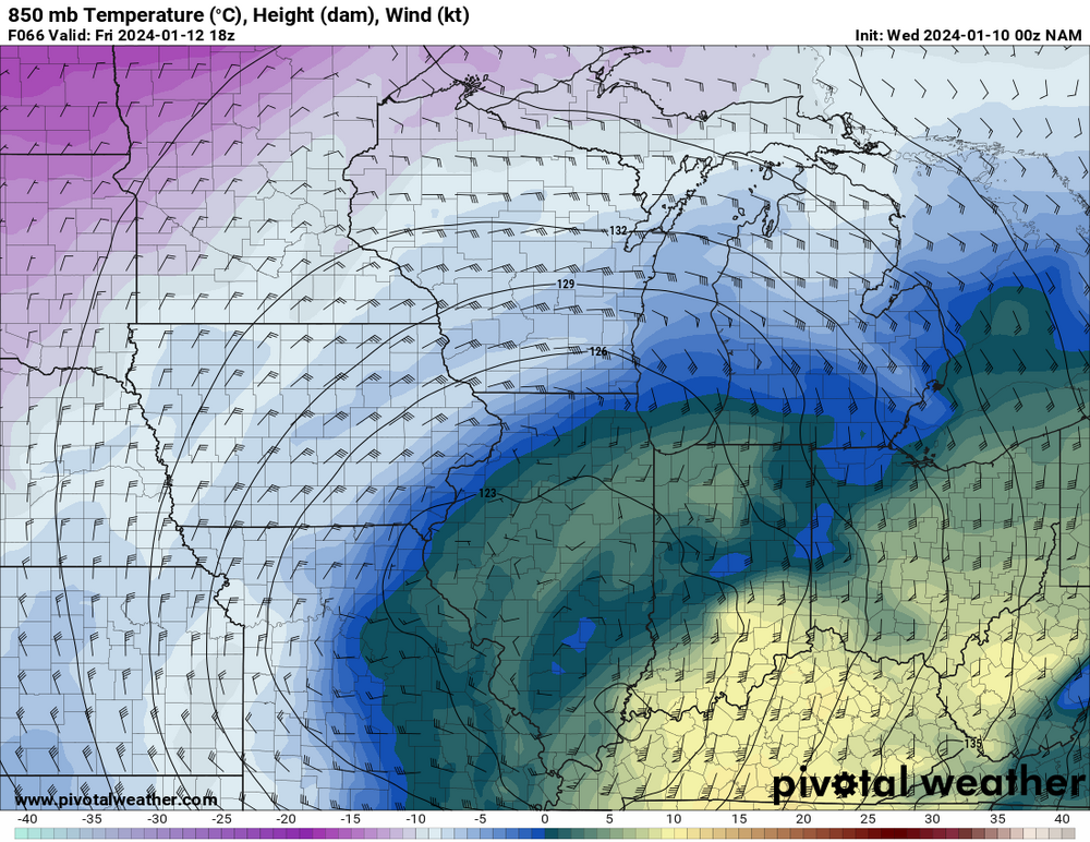
NAM has this huge slug of warm air aloft at 850 mb + the surface temps are marginal. Cuts into snow totals significantly across the board.
-
6 minutes ago, Stebo said:
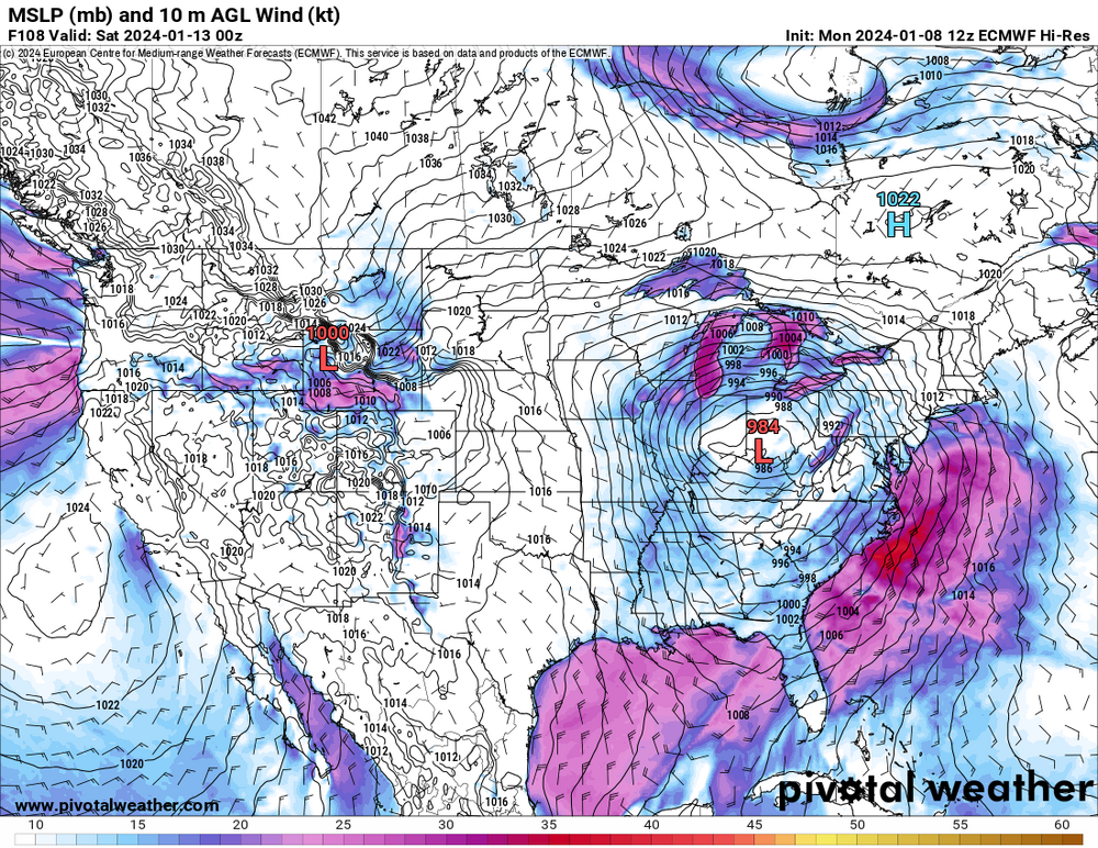
Still overamplified, its not hard to understand with minimal phasing that we aren't getting a sub 970mb low. Remember what today was supposed to be, in the low 970s and right now its about 10mb weaker than that.
Eh? The Euro/EPS is stronger because the primary shortwave is deeper and more organized than on the GFS, not really due to phasing.
-
4
-
-
2 minutes ago, Radtechwxman said:
How is that in comparison to the OP? I haven't had time to dive super deep into this one yet.
Decided weaker/east shift on the GEFS. Historic storm off the table there.
-
1
-
 2
2
-
-
-
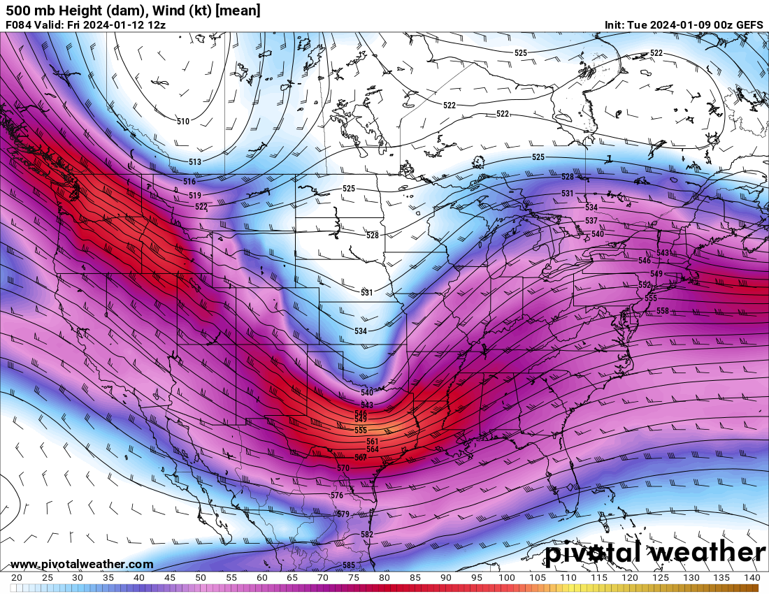
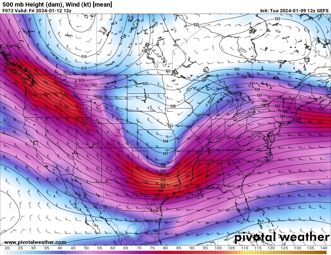
Lol main shortwave is too flat on the 12z GFS again.
-
Those 00z runs were almost unanimous on a top 5 type snowstorm for Chicago and a wide swath of the Midwest. This thing is an absolute nuke when that shortwave kicks negative tilt and the mass evacuation really intensifies.
The PV streamer into this thing is going to be a sight to behold on near-term guidance/satellite.
-
4
-
-
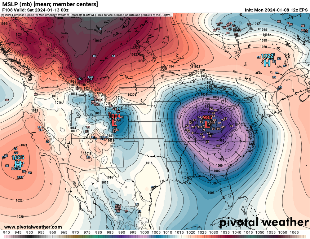
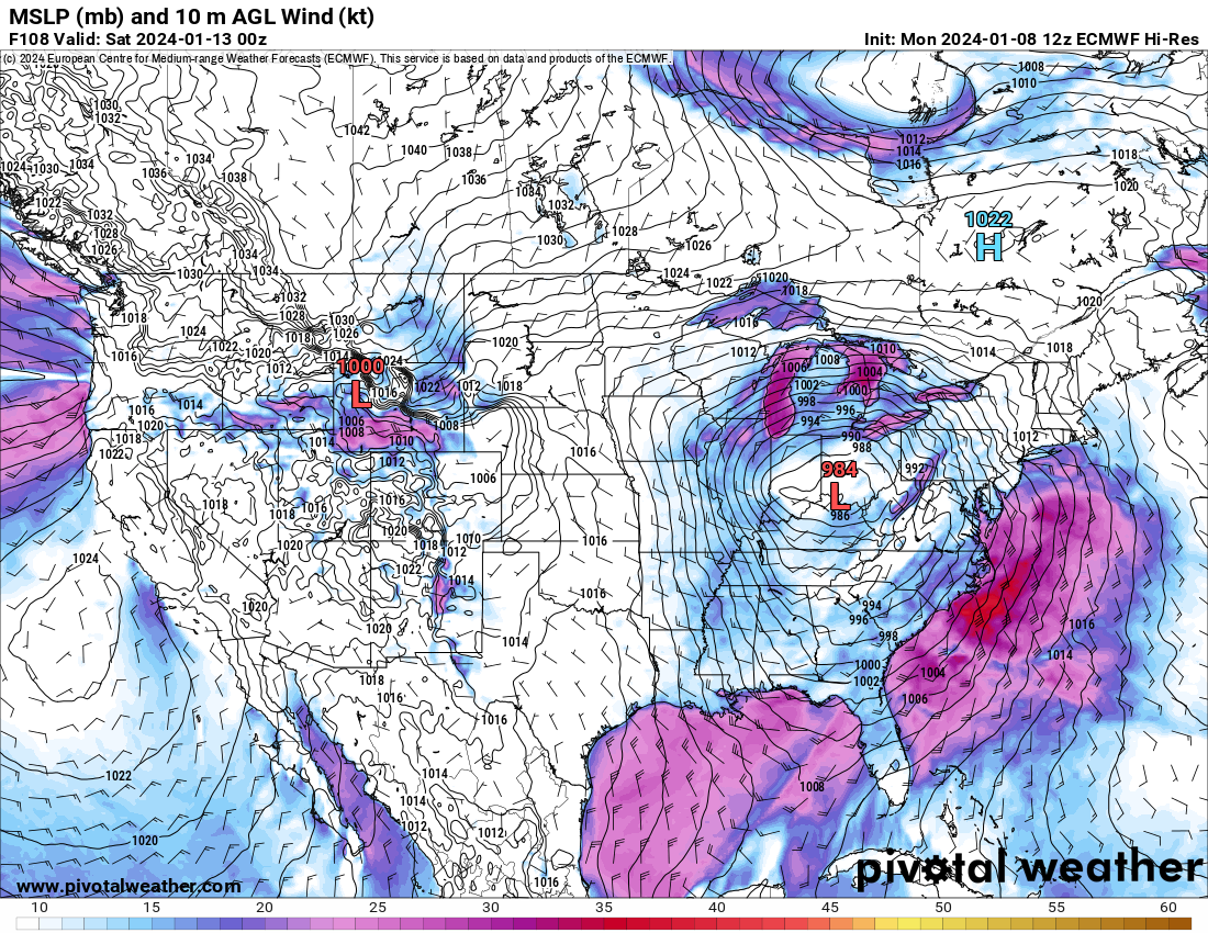
51 minutes ago, andyhb said:
12z Euro still has that slider/weaker look. Looks to track close to Cleveland.
Now with that said, there are a large number of members that are stronger/further north or west than the operational. Hell, the mean is nearly as deep as the operational at 108 hrs.
-
4
-
-
12z Euro still has that slider/weaker look. Looks to track close to Cleveland.
-
3
-
1
-
-
I'd imagine this one will be dubbed the MLK Blizzard if it comes to fruition.
-
2
-


2024 Short/Medium Range Severe Weather Discussion
in Lakes/Ohio Valley
Posted
...or not