

andyhb
-
Posts
20,231 -
Joined
-
Last visited
Content Type
Profiles
Blogs
Forums
American Weather
Media Demo
Store
Gallery
Posts posted by andyhb
-
-
That is quite a strong signal from the ECMWF seasonal, which is commonly warm biased with ENSO.
-
 1
1
-
-
Those are definitely not record setting May numbers. May 2003, 2004, and 2008 all had around 500 tornadoes, 2015 and 2019 were also more active.
-
1
-
-
HWRF with a high end Cat 3/Cat 4 landfall on Cancún and that may be underdone given current satellite presentation and ideal conditions for the next 36 hours.
-
1
-
-
10 hours ago, It's Always Sunny said:
Yeah I was looking at that yesterday it's definitely not out of the realm of possibility. Do you know what may be causing the NOAA/NASA/BoM models to go stronger? Wasn't sure if it was a model bias of some sort. One thought of mine is that those models in particular have a stronger area of suppression over the central Pacific resulting in stronger easterlies?
Your guess is as good as mine. I know the Euro tends to be a bit warm biased with ENSO and the CFS (NOAA) tends to be bullish with ENSO so I’d stake my claims somewhere in between. We haven’t had a Niña this well developed since probably 2010-2012.
-
1
-
-
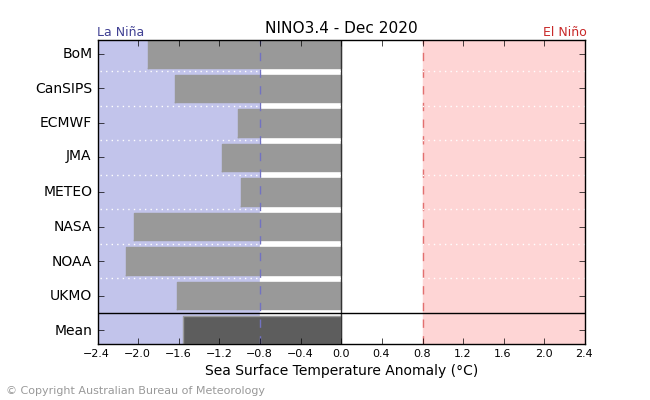
Latest Niño 3.4 multi-model ensemble from BOM is pretty locked into a moderate or even strong Niña peak in December.
-
1
-
-
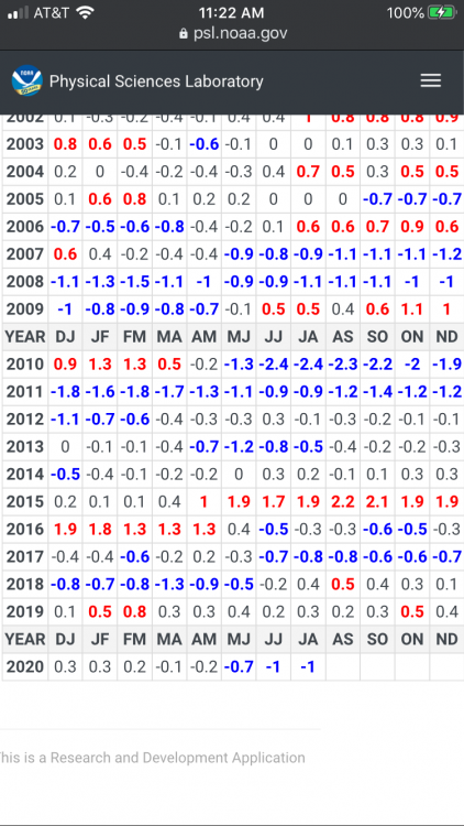
Closest match based on progression of Nino region SSTAs and MEI is probably 2007-08 at this point.
-
1
-
-
Can see it picking up the low frequency signal there.
-
Officially in La Nina conditions per WMO.
Thinking a moderate event is becoming increasingly likely with strong trade winds continuing near and east of the dateline.
-
4
-
-
Further intensification and westward progression of the Niña seems likely should this trade surge on the ECMWF come to fruition. Looks to me like we’re heading for a moderate event. Seems like MEI is paralleling 2007 as well to a decent degree.
-
2
-
-
On 9/11/2020 at 8:18 PM, madwx said:
2007-08 looks like a good analog. Especially if La Nina gets a little stronger than progged. Would take that winter and following severe weather season
This, especially after severe season completely shit the bed this year following April.
-
1
-
-
This should help cool the western ENSO regions a bit... -
Just now, CheeselandSkies said:
@andyhb, do you believe early spring 2021 will be similar to or perhaps even more violent than early spring 2020 (the Easter outbreak and I believe another one close to that timeframe)?
Will that translate into a similarly lackluster chase season for the Plains/Midwest, or is it impossible to make that connection at this point?
That's impossible to know for now. I'd lean towards a quieter than normal chase season though.
-
1
-
 1
1
-
-
Typed up a Twitter thread regarding this.
-
2
-
-
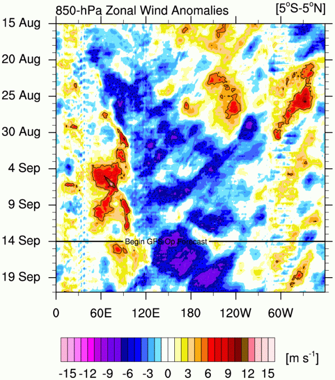
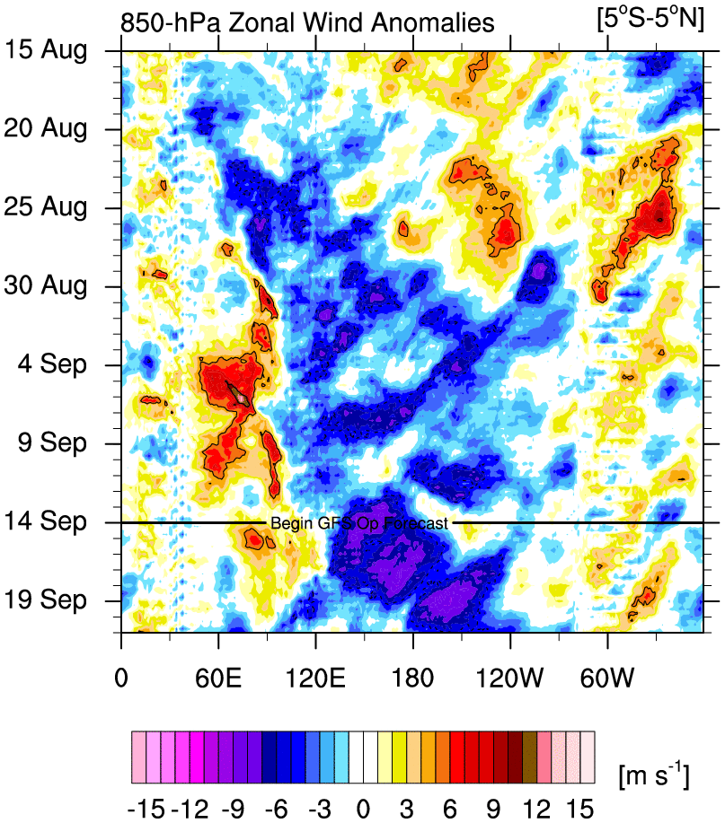
Should probably add the obvious Nina standing wave pattern showing up now in the 850 hPA zonal wind Hovmollers. Strong, sustained trades across most of the basin.
-
2
-
-
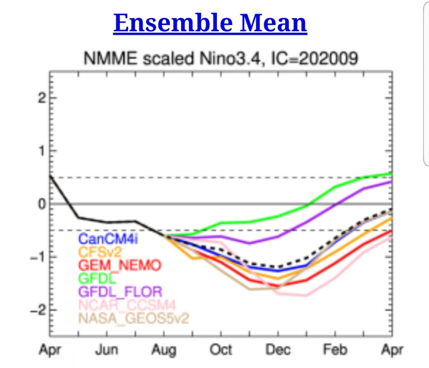
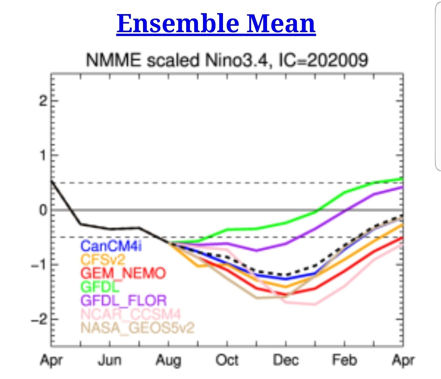
September run of the NMME is getting pretty aggressive with the strength of the Niña come winter, with the majority of members reaching moderate strength. Getting rather concerned about a very active cool season severe weather pattern given the drought conditions in the SW supporting efficient EML advection east of the Plains and the La Niña supporting SE/W Atlantic ridging.
-
3
-
-
7 minutes ago, Kmlwx said:
You know it's real when @andyhb pops into our subforum. Do you think we perform or bust tomorrow?
I'm a fan of the low level hodograph curvature I've seen on a few soundings, although I'd like to see the magnitude of the 850 mb flow increase a bit to be more sure on tornado potential. SPC mentions 30-40 kts, but most soundings I've pulled are more in the 20-30 kt range.
-
1
-
1
-
-
Quote
CONFIDENCE HAS INCREASED THAT AT LEAST SCATTERED STORMS WILL FORM OVER THE HIGHER TERRAIN OF THE CENTRAL APPALACHIANS AND/OR BLUE RIDGE MOUNTAINS BY PEAK AFTERNOON HEATING ON THURSDAY AS LARGE-SCALE ASCENT ASSOCIATED WITH THE SHORTWAVE TROUGH OVERSPREADS THIS AREA. RATHER POOR MID-LEVEL LAPSE RATES WILL PERSIST, BUT STRONG HEATING OF THE MOIST LOW-LEVEL AIRMASS SHOULD STILL YIELD MLCAPE OF 1500-2500 J/KG, STRONGER WITH SOUTHWARD EXTENT INTO VA AND THE DELMARVA. THE ENHANCED (40-50 KT) MID-LEVEL FLOW ATTENDANT TO THE SHORTWAVE TROUGH WILL FOSTER SIMILAR VALUES OF DEEP-LAYER SHEAR, AND ORGANIZED STORMS APPEAR LIKELY, WITH BOTH SUPERCELLS AND BOWING LINE SEGMENTS POSSIBLE. THIS CONVECTION IS EXPECTED TO SPREAD EASTWARD ACROSS THE MID-ATLANTIC LATE THURSDAY AFTERNOON AND INTO THE EVENING.
A FEW TORNADOES MAY OCCUR WITH ANY INITIALLY DISCRETE SUPERCELLS, AS A 30-40 KT SOUTHWESTERLY LOW-LEVEL JET SHOULD PROVIDE SUFFICIENT VEERING/STRENGTHENING OF THE LOW-LEVEL WINDS. THIS TORNADO POTENTIAL APPEARS TO BE MAXIMIZED THURSDAY AFTERNOON ALONG/EAST OF THE BLUE RIDGE MOUNTAINS INTO THE I-95 CORRIDOR OF MD/DC/NORTHERN VA. AT LEAST SCATTERED DAMAGING WINDS ALSO APPEAR LIKELY LATER INTO THE AFTERNOON AND EARLY THURSDAY EVENING ACROSS THIS REGION AND INTO THE DELMARVA, AS SOME CLUSTERING OF STORMS SHOULD OCCUR WITH EASTWARD EXTENT. CONFIDENCE IN THIS SCENARIO OCCURRING HAS INCREASED ENOUGH TO INCLUDE GREATER SEVERE PROBABILITIES FOR BOTH TORNADOES AND DAMAGING WINDS. A CORRESPONDING ENHANCED RISK HAS BEEN INTRODUCED ACROSS NORTHERN VA, DC, CENTRAL/EASTERN MD, DE, AND FAR SOUTHERN NJ TO ACCOUNT FOR THESE THREATS.
That's a pretty stout discussion on the SWOD2.
-
3
-
1
-
-
10 minutes ago, BYG Jacob said:
I can grasp context, you are bemoaning the lack of quality. So, my question was, why on Earth you expect such quality before September?
I don't know, because expecting more than 1 out of 15 storms through August to be beyond a Category 1 seems reasonable? Again, it's all relative to the amount of actual activity. Sure if we had only 6 named storms by now, it might look more impressive in terms of "quality" if we had 3-4 canes and 1 major.
-
2
-
-
9 minutes ago, BYG Jacob said:
This is coming from meteorologist, seriously? Were you expecting major hurricane in June or July?
And I said that where? Learn to read for context please.
By no means am I calling for a "season fail" the rest of the way through, but consider some actual, I don't know, statistics.
-
1
-
 3
3
-
-
When a derecho outclasses every storm but one so far, yeah it's been pretty lacking quality wise (then again, that derecho was historic, but I digress).
-
4
-
-
Those are absolutely bonkers.
-
2
-
-
The great annual Yanksfan takeover of the tropical threads is on.
-
 5
5
-
-
For all of those people wasting time with a...certain individual in the Laura thread, all I have to say is "divide by zero".
-
2
-
7
-
-
Holy mother of god. Warning: viewers with headphones might want to lower the volume.
Information about where it was filmed.
-
3
-
1
-

2019 ENSO
in Weather Forecasting and Discussion
Posted
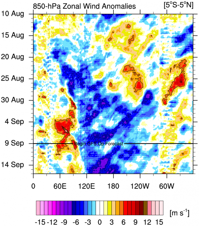
Strong/persistent Niña standing wave now and that NMME mean is impressive. Should probably note the rapid decay of the Niña in the new year might be problematic if it decays from east to west. A couple of previous studies have identified a link between a positive state of the Trans Nino Index (TNI), with colder waters in Nino 4 versus 1.2, and increased potential for tornado outbreaks especially east of the Plains in spring.