ncjoaquin
-
Posts
1,465 -
Joined
-
Last visited
Content Type
Profiles
Blogs
Forums
American Weather
Media Demo
Store
Gallery
Everything posted by ncjoaquin
-
2025-2026 Fall/Winter Mountain Thread
ncjoaquin replied to Buckethead's topic in Southeastern States
Hey Don. Sitting at not quite 6.5 inches. Not booming like some, but a steady increase. -
2025-2026 Fall/Winter Mountain Thread
ncjoaquin replied to Buckethead's topic in Southeastern States
I thought I was done a long time ago, but it has just kept snowing. Tremendous snow! -
2025-2026 Fall/Winter Mountain Thread
ncjoaquin replied to Buckethead's topic in Southeastern States
Surprisingly has picked back up! I thought I was done. -
2025-2026 Fall/Winter Mountain Thread
ncjoaquin replied to Buckethead's topic in Southeastern States
I hope that you make it! -
2025-2026 Fall/Winter Mountain Thread
ncjoaquin replied to Buckethead's topic in Southeastern States
Still snowing, but light snow. Probably sitting about 5 inches. Even if it doesn't pick back up, I'm happy. -
That's a great picture!
-
2025-2026 Fall/Winter Mountain Thread
ncjoaquin replied to Buckethead's topic in Southeastern States
18.1 here, but I am amazed how big the flakes are. -
2025-2026 Fall/Winter Mountain Thread
ncjoaquin replied to Buckethead's topic in Southeastern States
Absolutely hammering here! My best snow so far. Haven't measured, but I will estimate 4 inches. -
2025-2026 Fall/Winter Mountain Thread
ncjoaquin replied to Buckethead's topic in Southeastern States
No measurement here, but it is a thick blanket of white and snowing hard! -
2025-2026 Fall/Winter Mountain Thread
ncjoaquin replied to Buckethead's topic in Southeastern States
We are bouncing around like the ping pong balls in a lottery drawing.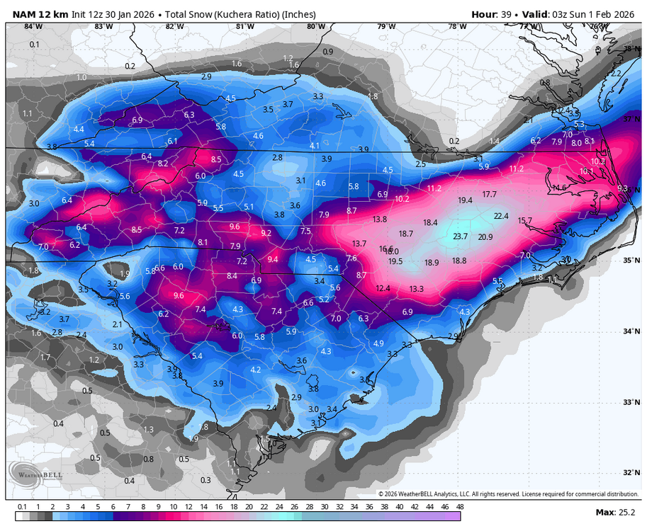
-
2025-2026 Fall/Winter Mountain Thread
ncjoaquin replied to Buckethead's topic in Southeastern States
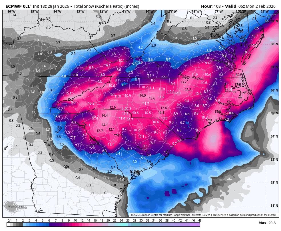
Below is for all mountain counties. GSP has upped it again. My current temp is 15.8. It has been a long time since I have been in the teens the morning of a snow storm. WINTER STORM WARNING REMAINS IN EFFECT FROM 4 PM THIS AFTERNOON TO 7 AM EST SUNDAY... * WHAT...Heavy snow expected. Total snow accumulations between 5 and 8 inches. Winds gusting as high as 50 mph. * WHERE...The mountains of North Carolina. * WHEN...From 4 PM this afternoon to 7 AM EST Sunday. -
2025-2026 Fall/Winter Mountain Thread
ncjoaquin replied to Buckethead's topic in Southeastern States
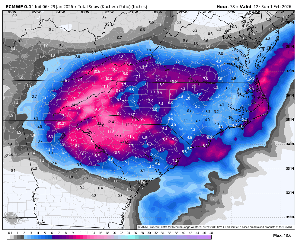
Never seen a model be this consistent.
-
2025-2026 Fall/Winter Mountain Thread
ncjoaquin replied to Buckethead's topic in Southeastern States
Euro holding steady.
-
2025-2026 Fall/Winter Mountain Thread
ncjoaquin replied to Buckethead's topic in Southeastern States
Good assessment! I agree with all of this. -
2025-2026 Fall/Winter Mountain Thread
ncjoaquin replied to Buckethead's topic in Southeastern States
Agreed! That will do. -
2025-2026 Fall/Winter Mountain Thread
ncjoaquin replied to Buckethead's topic in Southeastern States

-
2025-2026 Fall/Winter Mountain Thread
ncjoaquin replied to Buckethead's topic in Southeastern States
Now, that is perfect! -
2025-2026 Fall/Winter Mountain Thread
ncjoaquin replied to Buckethead's topic in Southeastern States
That would work! -
2025-2026 Fall/Winter Mountain Thread
ncjoaquin replied to Buckethead's topic in Southeastern States
It's probably blasphemy to say that I would be thrilled with 7 inches and let the ENC fellows have the 24 inches that the GFS shows. There are too many problems that come with 2 feet of snow! I know I am a stranded loner on an island by myself with that opinion, lol! I mean. Don't get me wrong. I would take it ! But, any decent snow works for me. -
2025-2026 Fall/Winter Mountain Thread
ncjoaquin replied to Buckethead's topic in Southeastern States
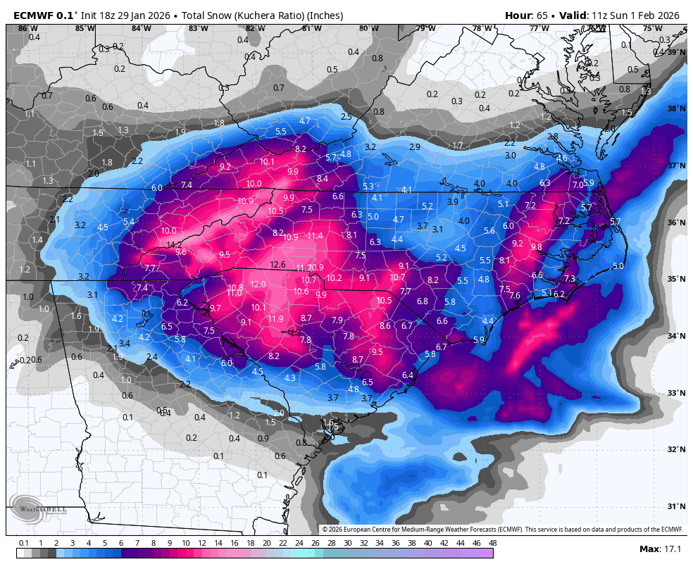
84 hour nam, so the typical grain of salt, but I like it.
-
2025-2026 Fall/Winter Mountain Thread
ncjoaquin replied to Buckethead's topic in Southeastern States
Give me 3 inches of snow and I wouldn't complain, based on the last few years. I will take more, but I am not greedy. High ratios will help out even if the moisture is lacking. I am hanging my hat on that! -
2025-2026 Fall/Winter Mountain Thread
ncjoaquin replied to Buckethead's topic in Southeastern States
We are all assholes at point or another, lol. I would happily give it a C. I still have power, and so far all my family does too. No matter what, it's going to be slicker than crap in the morning. We have a good group on here! -
2025-2026 Fall/Winter Mountain Thread
ncjoaquin replied to Buckethead's topic in Southeastern States
I read the only place you could get it was Stormvista. Take that with a grain of salt though. -
2025-2026 Fall/Winter Mountain Thread
ncjoaquin replied to Buckethead's topic in Southeastern States
That sucks. I'm sorry. Not having power is miserable. I hope that they get it fixed quickly. -
2025-2026 Fall/Winter Mountain Thread
ncjoaquin replied to Buckethead's topic in Southeastern States
Got up to 31.8. I thought I was going over the top, but fell back to 31.5.