forkyfork
-
Posts
30,756 -
Joined
-
Last visited
Content Type
Profiles
Blogs
Forums
American Weather
Media Demo
Store
Gallery
Everything posted by forkyfork
-

October 2020 General Discussions & Observations Thread
forkyfork replied to uofmiami's topic in New York City Metro
dense fog tonight and tomorrow morning
-
October 2020 General Discussions & Observations Thread
forkyfork replied to uofmiami's topic in New York City Metro
lol.thumb.gif.ea99d6701a348e2c1fc976ae09dac3c3.gif)
-
October 2020 General Discussions & Observations Thread
forkyfork replied to uofmiami's topic in New York City Metro
we get some westerly component to the sfc flow wednesday so ewr might have a shot at 80 -
October 2020 General Discussions & Observations Thread
forkyfork replied to uofmiami's topic in New York City Metro
the 0z euro has barely any rain for the next 10 days -
so many people don't seem to know what happens to pumpkins within hours of putting them outside
-
October 2020 General Discussions & Observations Thread
forkyfork replied to uofmiami's topic in New York City Metro
i've seen the lantanas at my parents' house make it to december -
useless

-
Beneficial 1-3" rain, iso 4.5" 2PM Sunday 11th-2PM Tuesday Oct 13
forkyfork replied to wdrag's topic in New York City Metro
1.83 in springfield -
Beneficial 1-3" rain, iso 4.5" 2PM Sunday 11th-2PM Tuesday Oct 13
forkyfork replied to wdrag's topic in New York City Metro
read walt's posts -
Beneficial 1-3" rain, iso 4.5" 2PM Sunday 11th-2PM Tuesday Oct 13
forkyfork replied to wdrag's topic in New York City Metro
tonight has the potential to overperform and get us closer to the original forecast amounts -
Beneficial 1-3" rain, iso 4.5" 2PM Sunday 11th-2PM Tuesday Oct 13
forkyfork replied to wdrag's topic in New York City Metro
the euro has been overdoing these weak lows all year -
Beneficial 1-3" rain, iso 4.5" 2PM Sunday 11th-2PM Tuesday Oct 13
forkyfork replied to wdrag's topic in New York City Metro
ouch -
Beneficial 1-3" rain, iso 4.5" 2PM Sunday 11th-2PM Tuesday Oct 13
forkyfork replied to wdrag's topic in New York City Metro
this is starting to look like a bust -
October 2020 General Discussions & Observations Thread
forkyfork replied to uofmiami's topic in New York City Metro
delta's remnants sped up at the last minute -
post your favorite shrimper photos
-
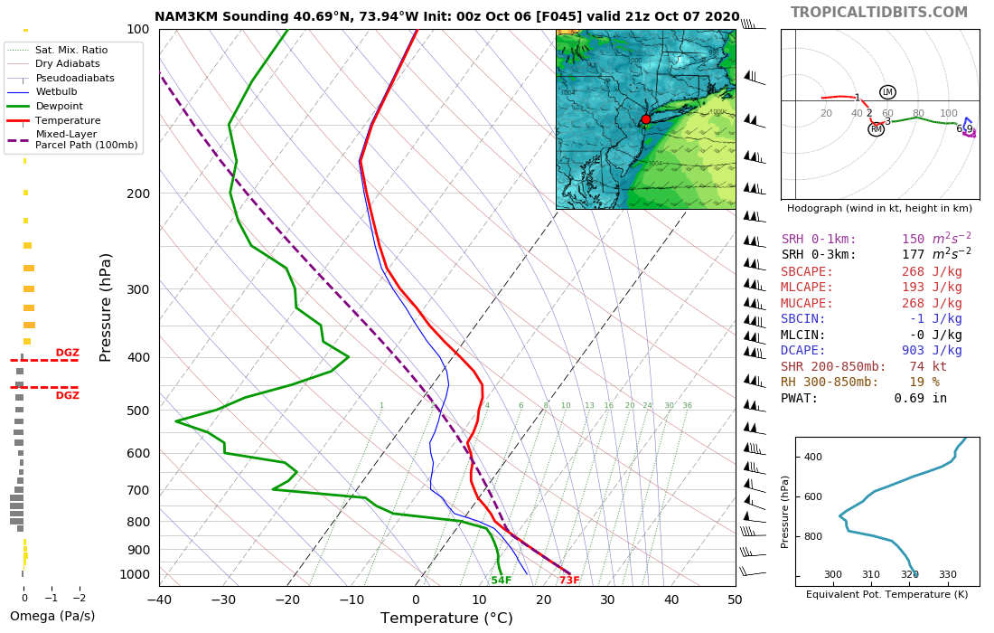
Wednesday, October 7, 2020 Convective Potential
forkyfork replied to weatherwiz's topic in New England
a watch should have been issued as soon as reports started coming in -
Wednesday, October 7, 2020 Convective Potential
forkyfork replied to weatherwiz's topic in New England
a moderate risk would have verified -
Wednesday, October 7, 2020 Convective Potential
forkyfork replied to weatherwiz's topic in New England
with the winds aloft all you needed was just enough cape -
Wednesday, October 7, 2020 Convective Potential
forkyfork replied to weatherwiz's topic in New England
continuous wind damage from lake ontario to the coast -
Wednesday, October 7, 2020 Convective Potential
forkyfork replied to weatherwiz's topic in New England
low dewpoint derecho -
showers ruined our wind threat in the nyc metro
-
so we're wasting another one on shrimp people
-
October 2020 General Discussions & Observations Thread
forkyfork replied to uofmiami's topic in New York City Metro
i thought we had good frost potential thursday night. oops
-
October 2020 General Discussions & Observations Thread
forkyfork replied to uofmiami's topic in New York City Metro
50 kt gust potential wednesday with temps in the 70s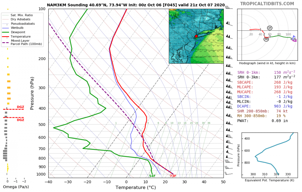
-
October 2020 General Discussions & Observations Thread
forkyfork replied to uofmiami's topic in New York City Metro
there isn't nearly enough time

.gif.45a329696a9951c9f6e39b3ec8ffc4be.gif)