buckeye
-
Posts
8,844 -
Joined
Content Type
Profiles
Blogs
Forums
American Weather
Media Demo
Store
Gallery
Everything posted by buckeye
-

Winter 2022/23 Medium/Long Range Discussion
buckeye replied to Chicago Storm's topic in Lakes/Ohio Valley
me too.... that's a hell of a Merry Christmas courtesy of the folks up north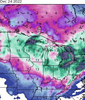
-
3 week scheduled maintenance bump
-
Winter 2022/23 Medium/Long Range Discussion
buckeye replied to Chicago Storm's topic in Lakes/Ohio Valley
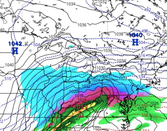
I've never seen 500 maps as crazy as they've been. Everything is fast moving and blocky at the same time. If you do model run comparisons beyond 120 hours, the changes and differences are night and day run to run.. Gotta be a nightmare for forecasters. -
Me too. My body doesn't handle cold like it use to. Every winter I start to understand more and more why people move south after retirement. Of course I still love a good snow if I'm going to be in this climo anyways.
-
We will challenge our record today which was previously set Nov 6 1977. Therefore my official winter analog is 77-78
- 176 replies
-
- 10
-

-

-

-
so no mod this winter and the Ohio crowd has yet to self-quarantine.... Juice up the storm track and it's gonna be thunderdome in here.

-
43 pages in their winter spec thread. I suspect they'll be cancelling winter by next week.
-
better yet. GFS says we, (central ohio), after tomorrow, don't go sub 40 for the next 16 days. Absolutely love warm dry Novembers.
-
- latest measurable snowfall? - least snowfall? - both? due to CAD or WAW?
-
Another Westervillian!
-
March 8,9 2008 TWO MONTHS EARLIER In general I like snowstorms between the window of xmas and the end of January. I also favor duration over intensity. I recall an upper low that parked itself over the area back in the mid 90's that produced steady light snow over the entire weekend and we ended up with 9" by Sunday evening. I also like a well-forecasted snowstorm that locks in 4 days out, (a true rarity in CMH where we ride the razor's edge with every storm).
-
2022 Short/Medium Range Severe Weather Discussion
buckeye replied to Chicago Storm's topic in Lakes/Ohio Valley
SR and meso's really sucking on placement of storms and heavy rain, (at least over the eastern part of the sub and OV). -
2022 Short/Medium Range Severe Weather Discussion
buckeye replied to Chicago Storm's topic in Lakes/Ohio Valley
Models are all over the place. -
I wish there was a way we could punish volcanos for their utter disregard of the enviornment.
-
Spring 2022 Medium/Long Range Discussion
buckeye replied to Chicago Storm's topic in Lakes/Ohio Valley
miserable spring wx -
Well, I guess it's been 72 hrs. Barring any last minute shift to a deeper, more negatively-tilted trough, this looks like a glorified frontal passage with advisory snow overnight Friday into Saturday. Considering it's March.....yawn.
-
those aren't the same "S's"
-
Let's see how it looks in 48 hrs.
-
temps busted cold today, didn't get above freezing. I think the freezing rain threat is looking more likely now...low level cold air is going to be hard to dislodge, especially without a strong low pushing the warm tongue. Hope it turns out to be the usual freezing rain event around here which is usually pretty harmless.
-
That lull between the first batch of light precip and the bigger follow up batch is what allows levels to warm enough to keep us from getting a slop fest. By the time that second batch comes in it's rain. This one doesn't bother me. It's a crap storm overall even in the snow sector... no one is getting 'buried'.
-
last minute trends are for warmer air winning out. Franklin county might be primarily rain.....which is fine with me if the only other choice is sleet/frz rain.
-
if a 1011 low in south central KY with a fresh 1040 banana high sprawled out north of us can still warm tongue us, we might as well give up.
-
Too early to call. We have a rain storm that has to go first. My gut says this trends southeast. Another positively tilted trough opening up as it heads east with a fairly weak storm/wave riding the front. Also pretty decent banana high in place. I just saw the 12zUkmet just crushed the storm into nonexistence.
-
Looks like there is an initial storm around Tuesday that will be a rainer for most.... it's what happens after that. All the models are showing that once the first storm goes through the baroclinic zone sinks south of us and the gulf opens up again. Looks like a possible chance of a nice overrunning event later next week. 6z euro ens shows this as well now. All caveats are possible.... if return flow is stronger with a stronger low, we warm tongue.... if front pushes further south we smoke cirrus. I'm feeling good for something wintry, hopefully not ice though.
-
Winter 2021-22 Short/Medium Range Discussion
buckeye replied to Chicago Storm's topic in Lakes/Ohio Valley