

BullCityWx
-
Posts
8,892 -
Joined
-
Last visited
Content Type
Profiles
Blogs
Forums
American Weather
Media Demo
Store
Gallery
Posts posted by BullCityWx
-
-
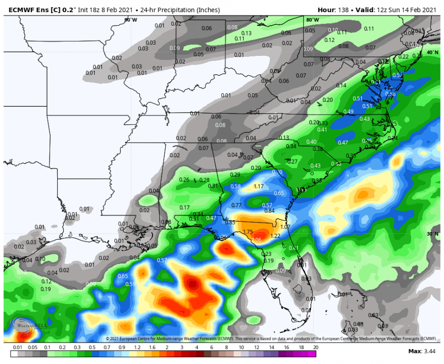
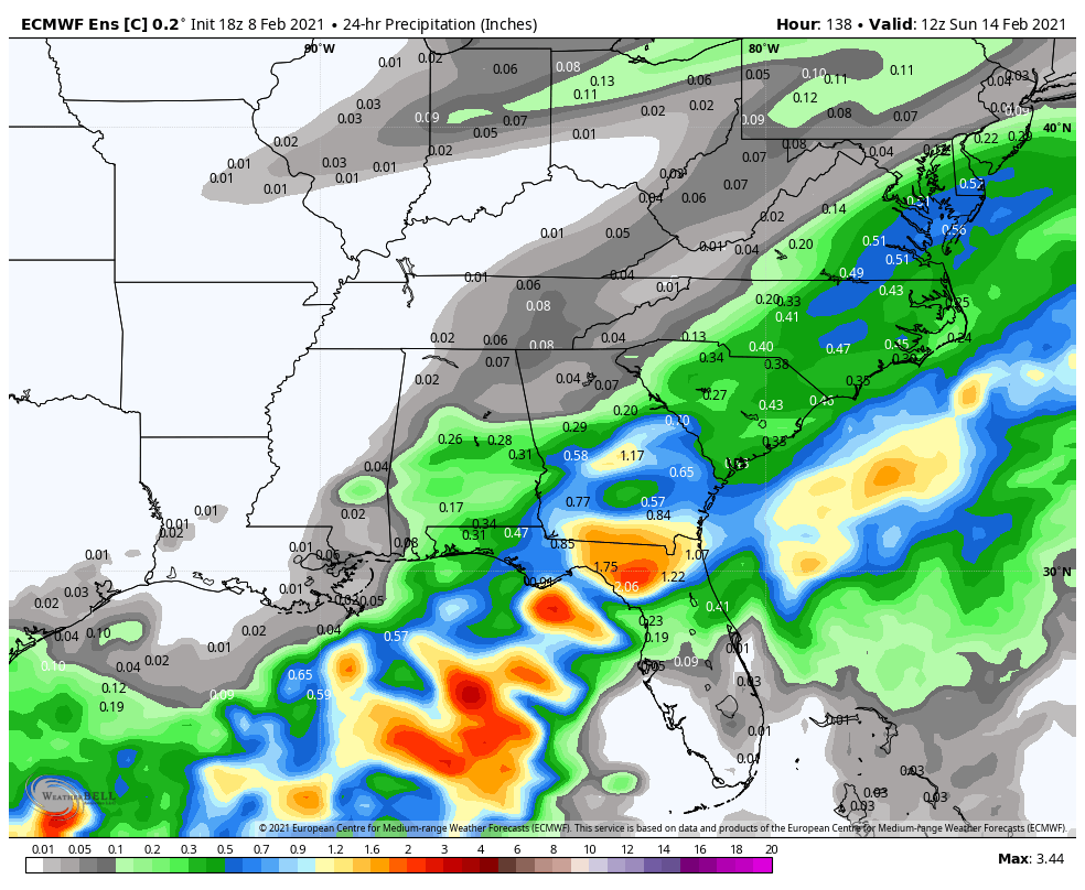
That Saturday setup is gonna be sneaky. Temps here in the upper 20s with .2 qpf should lend itself to some decent accrual.
-
2 minutes ago, weatherlover said:
Is this for the Thur night/Friday event?
No. Thursday and Friday likely limited to north of 40 and even then maybe further north.
-
My guess is there's no way there's that much zr(geographically speaking). Probably a ton of sleet somewhere.
-
1 minute ago, burrel2 said:
Raging ice storm on the icon... similar to the euro but not as amped and... colder???
Looked to me like it would flip to snow at 180ish.
-
0z ICON has a temp IMBY of 20 degrees on Tuesday at 1PM.
-
31 minutes ago, Buckfever2 said:
My wife and two kids are supposed to be driving out to Phoenix, leaving out on this Friday from Dallas Georgia.I’m wondering should we postpone that trip, especially with all the uncertainty?
I think you’re fine there. If you were up here, I’d be concerned.
-
27 minutes ago, burrel2 said:
How’d the 18z euro look at 144hrs in regards to next weeks storm?
No real sign I could decipher on the mean.
-
 1
1
-
 1
1
-
-
2 minutes ago, Buckfever2 said:
Can you post that second round that it showing
Mostly sleet or freezing rain for that QPF. Probably more sleet along and north of 85, freezing rain more prevalent south of 40.
-
 1
1
-
-
The control run has a second round of...something on Saturday. It’s either freezing rain or sleet.
-
9 minutes ago, griteater said:
Late week is like the junior undercard bouts, while early next week has Mike Tyson vs Buster Douglas potential, with Michael Buffer doing the intros
Ha, I remember I was camping with my dad at one of the textile mill campgrounds on LKN that weekend and we recorded the fight on VHS. Boy was I surprised.
I tend to agree there especially if we get the full cold push.
-
The Euro, ICON, GEM, NAM, RGEM all show Friday. GFS is a clown show.
-
4
-
-
19 minutes ago, tarheelwx said:
No real trend on the 18z RGEM. I'd say less of a winter storm over northern NC that run.
TW
Less QPF that run.
-
-
That low is not going to bully that high out of the way. That is laughable.
-
3
-
-
1 minute ago, ILMRoss said:
euro 8 day has a cad high that looks a doodle a college kid in synoptic makes trying to draw up the perfect ice storm. yikes.
Yeah, last time we had anything similar to that strength of a high, would've been the supercad storm in 2010. I had thundersleet in Gastonia for that one.
-
180 has freezing rain breaking out in Birmingham and Atlanta.
-
Just now, NorthHillsWx said:
That is, umm, a cold look for the Carolinas
Yeah, I'm definitely concerned with the coming cold if we have a big ice storm.
-
Snow breaking out over a good chunk of Texas at 174.
-
Looks like the arctic front is about 12 hours slower than the UKMET.
-
Just now, PackGrad05 said:
Not sure how much better we can get for Wake. Need that HP to trend even stronger. Typical CAD areas favored again.
For the coastal plain of Wake? Yes. For north of 540? not much.
-
Pretty strong signal on GEPS that reflects the RGEMs solution.
-
 1
1
-
-
Last frame of the UKMET is 12z Sunday. It's -5 in Nashville, -11 in Louisville and 6 degrees in Huntsville. The arctic front is crossing NC with some arctic front snow.
-
3
-
-
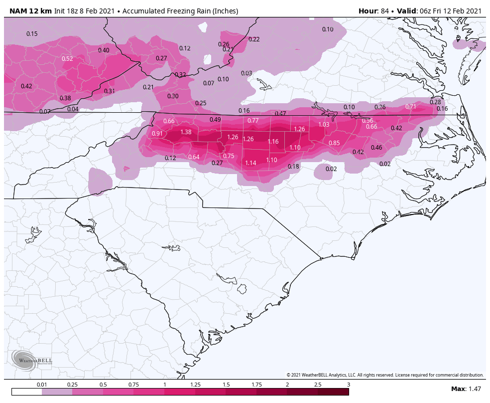
Canadian, in my back yard, looks like sleet/freezing rain 28-30 degrees.

-
2 minutes ago, WXNewton said:
With all of this potential energy moving through over the next 2 weeks, I have a feeling that we could see a storm seemingly appear out of nowhere and trend our way with very limited lead time.
I feel like that Friday storm might be the one. I have a feeling it's gonna take while for the GFS to catch up fully and potentially the Euro.
-
1
-
Mid to Long Term Discussion 2021
in Southeastern States
Posted