

BullCityWx
-
Posts
8,892 -
Joined
-
Last visited
Content Type
Profiles
Blogs
Forums
American Weather
Media Demo
Store
Gallery
Posts posted by BullCityWx
-
-
That was well on its way to a significant ice storm by hour 84.
-
46 minutes ago, chapelhillwx said:
Bring the mojo! Now before this thread gets into full swing I hope we can spare everyone the discussion about how much each poster does or doesn't want an ice storm... the weather doesn't care whether you want it or not and honestly neither does the forum
Amen to that.
-
 1
1
-
 2
2
-
-
Seems like we have decent enough agreement to start a thread.
-
Just now, wncsnow said:
The euro has burned me a few times this year, hard to take its solutions as serious as years past. Next week is our real chance, I don't think the Thursday or Friday systems will be cold enough except for the NC/VA border areas. Who wants multiple days of 35 and rain?
I mean I sure dont but I have half an inch of ice accretion about 12 miles from my front door.
-
1 minute ago, wncsnow said:
So you think its faster with the cold?
I think it looks just fine. There's a "cold rain" warning criteria ice storm this run for the triad and northern triangle. It's slightly less impressive than the GFS and ICON but it's still there.
-
Euro is trying to pull an ICON for Saturday.
-
1 minute ago, wncsnow said:
Euro looking slower with the cold again through 102
Back down in the dumps again?
-
1
-
-
Just now, WinstonSalemArlington said:
Is that to South Hill/Roanoke?
Roanoke to Farmville to the coast.
-
2 minutes ago, griteater said:
The fail scenario though is the high getting hung up too far west like the UKMet with the TPV not progressing east / ESE fast enough...or that would postpone things anyway
yeah, it's definitely not air-tight.
-
the 0z 850 degree has moved about 100 miles south today on the euro for Friday.
-
Okay, lets think about this. If the evolution of all of this happens like it might, there's going to be snow cover to just 50 miles N of the NC/VA border. How is that cold air going to moderate? If the evolution goes like we've seen and we get the damming high over NYS, it's a matter of ptype. Someone is going to get clocked with freezing rain and I still think the snow cover already here is going to push the thermal boundaries south. I could see this being a damming event that reaches Birmingham.
-
1
-
-
Just now, Lookout said:
Yep. If this comes to pass, this high and cold is a different beast than the endless parade of marginal cad events we have had recently. The 12z gfs and Canadian are showing minimal temps of the wedge in the mid teens around 950 to 925mb all the way into ne ga. Been a long time since we have seen a cad event that cold.
I figured this one would pull you out of the woodwork!
-
2
-
 2
2
-
-
so if I'm looking at the GFS for MBY:
.2 ice accretion on Friday
.3 ice accretion on Saturday
3" snow on Tuesday with temps around 20.
I dont know if it'll be right but wow.-
2
-
-
This run is more realistic to what I think could happen with a high in that position and of that strength. Snow to sleet from GSP to RDU with freezing rain from Columbia to Greenville, NC.
-
2
-
-
45 minutes ago, HKY_WX said:
If this comes to pass, I look forward to watching the northern transplants in Raleigh attempt to drive to work on ZR at 20 degrees... "'Cause they are used to that up north...."
No offense to northern transplants in Raleigh who view this board (you're obviously excluded)
")
Aint that the truth.
-
It could be lights out for people before Tuesday.
-
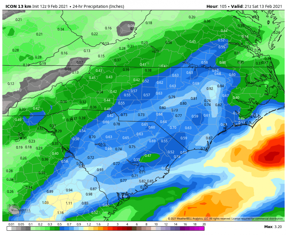
ICON has a warning criteria ice event on Saturday for RDU and CLT metros.
-
1 minute ago, CaryWx said:
In the next 84hrs Bull?
I would say for areas N&W of 85 in the triangle for sure, possibly further south.
-
1 minute ago, WXNewton said:
Maybe today the trend will be for a 2nd batch of precip building in during the early morning hours on Saturday. With the frigid airmass to our north slowly sinking in this would possibly lead to a lot of light freezing drizzle/sleet that might be more extensive than the models are detecting.
It could definitely go that route. If you were going to ask me for a perfect scenario for a multi-day freezing drizzle event, this is pretty much it. Rare around these parts but so is the cold air
-
Just now, olafminesaw said:
It's been picking up on that feature behind the initial push of moisture. Could lead to a decent amount of icing, as the precip isn't particularly heavy.
Yeah, it's really the perfect recipe for a multi-day freezing rain event.
-
Also tries hard to have mostly sleet N&W of 85 in the triad and triangle.
-
2
-
-
It looks like the NAM is showing a multi-day ice event.
-
2
-
-
2 minutes ago, burrel2 said:
Euro would be predominantly sleet for the upstate and most of North Carolina. Check out the frigid 925mb temps.
Yep
-
6z EPS is slightly colder for Saturday and would indicate an icy mess from Winston to N&W of 40/85 in Orange/Durham.
Ice/Snow threat Friday-Sunday
in Southeastern States
Posted