

BullCityWx
-
Posts
8,892 -
Joined
-
Last visited
Content Type
Profiles
Blogs
Forums
American Weather
Media Demo
Store
Gallery
Posts posted by BullCityWx
-
-
Already looking at warning criteria by tomorrow morning.
-
 1
1
-
-
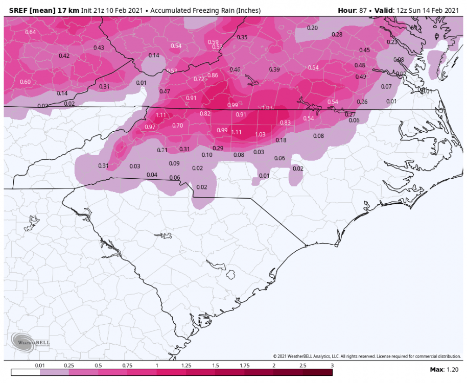
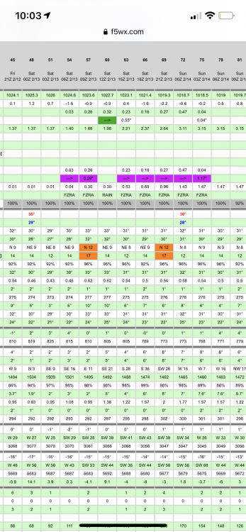
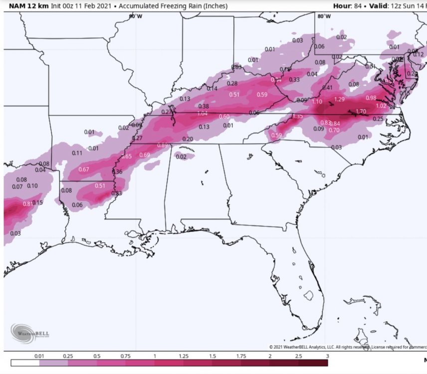
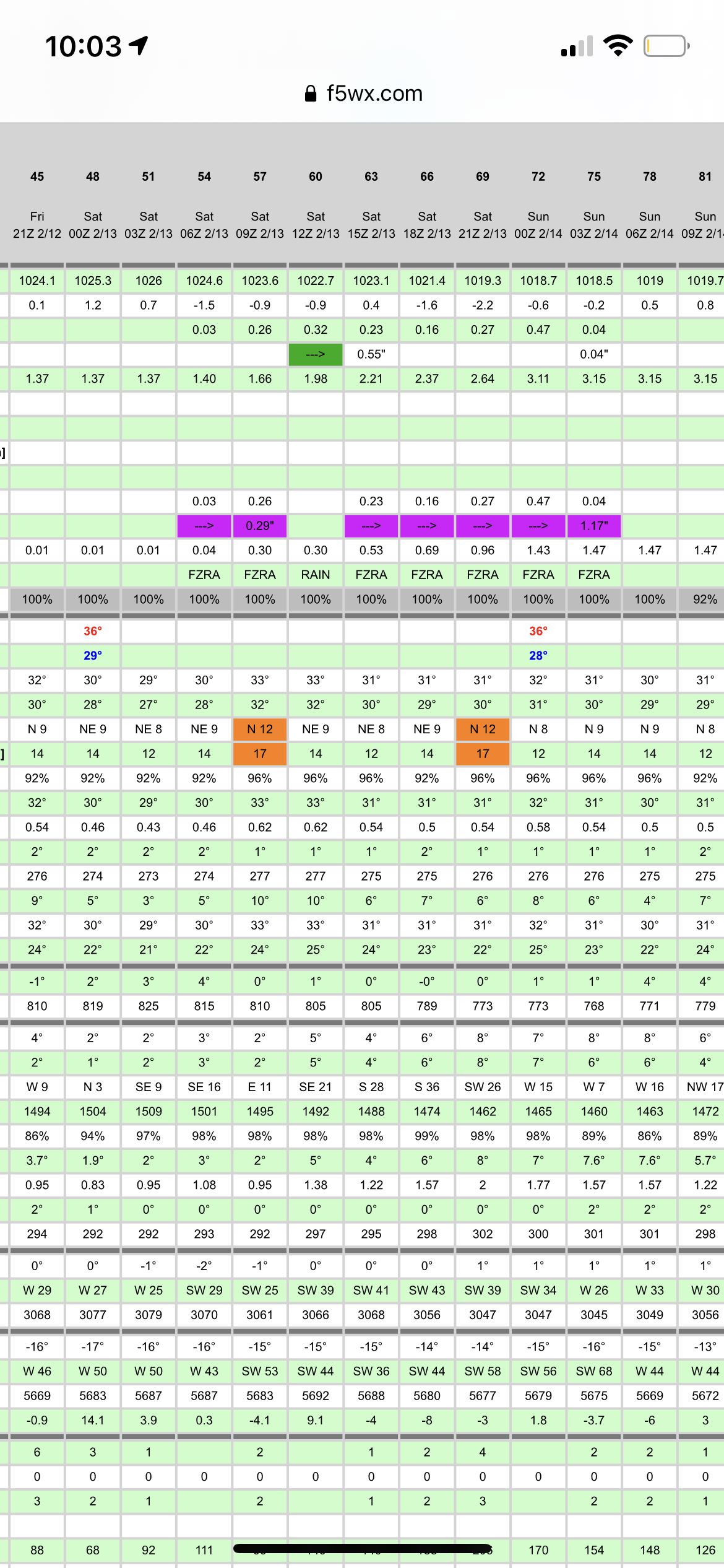
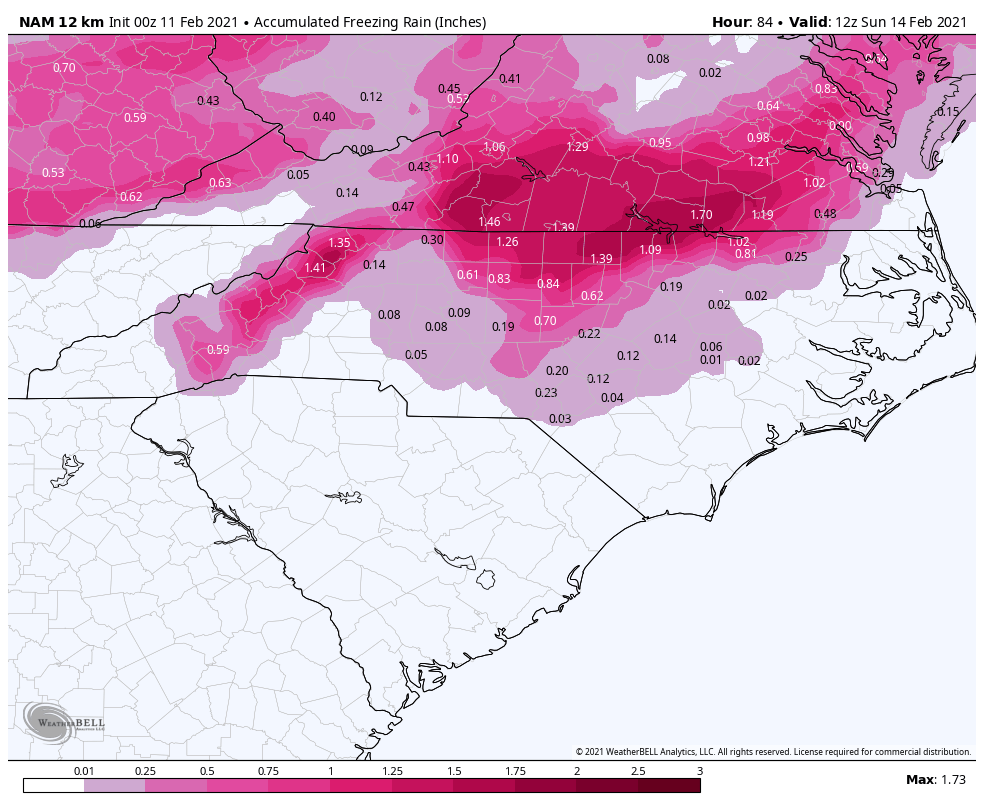
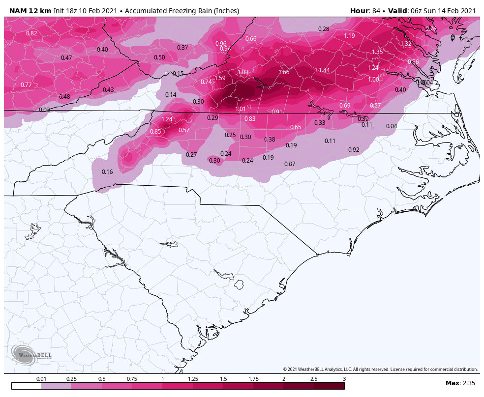
12k NAM at 12z is icier than 0z through 1PM tomorrow.
-
3 minutes ago, magpiemaniac said:
WPC update (part 2)


-
3 minutes ago, jjwxman said:
How much ice did you have? That’s definitely the benchmark ice storm for the Triad area.
Right at an inch. It is probably the worst natural disaster in the Charlotte Metro in my forty years here.
-
Just now, jjwxman said:
The ice maps for the NAM are assuming everything freezes on contact. That’s simply not going to happen with temps 30-32. Freezing rain as we all know is self limiting anyway. I’m not an ice fan at all, but if for some reason you like no power for two weeks, you would want the surface temps to be on the order of 26-27. In Dec 2002 I measured 0.75 on the tree branches in MBY. We managed to stay 26-28 degrees the entire event.
I was at 30-31 for most of freezing rain part of that event
-
 1
1
-
-
@ILMRoss you bring really good insight. Thank you.
-
5
-
-
So this is suboptimal as well
-
 1
1
-
-
2 minutes ago, tarheelwx said:
I remember a devastating ice storm up in Wytheville back in the mid 90's or so. Every yard I drove past had some sort of tree damage. Probably at least an inch of ice or so.
TW
You probably remember 12/02. Most of the accrual in that event happened with heavy rain(thunderstorms actually at one point) at 30 degrees.
-
RIP tree canopy
-
Just now, buckeyefan1 said:
Silly NAM continues to creep

Hell it’s almost like we’ve lived through some of these
-
1
-
-
One critical thing I noted this run was it gets me down to 30 before the main event.
-
1
-
-
10 minutes ago, WXNewton said:
Also saw Brad P. in house model tonight and it had almost all of NC in Freezing rain and dropped temps in HKY to 31. It was definitely interesting and seems like other guidance is not too far off from what he was showing. He also seemed a little more excited about a legit ice threat.
Was that on FB live?
-
Just now, WXNewton said:
Just makes me wonder about Mon/Tuesday storm after watching the trends today. Do we see the same thing happen with that storm as we get closer with the wedge showing up a little stronger each run and pushing deeper to the south?
Entirely plausible. I’ve seen it happen time and time again.
-
-
1 minute ago, tarheelwx said:
Very interesting that the NAM shows the wedge retreating around daybreak on Saturday, but then digging back in as the morning wears on. I"m not sure I've ever seen that. Maybe the low is transferring to the coast and negating the surge of warm air?
TW
I wonder if it cools back down because we’re no longer having the heat transfer
-
14 minutes ago, magpiemaniac said:

So 50-50 shot for MBY for .25 yet RAH thinks 0.01?
-
55 minutes ago, eyewall said:
Ok you are right and I am sorry. I have not been doing well outside of weather with a friend permanently damaged health wise by COVID and he lost his dad to the illness. I suppose I let that carry over to my posts here without thinking it through first. Anyway, I am awaiting the RAH discussion to see their line of thought given the latest runs for next week.
I hope things get better bud.
-
6 minutes ago, eyewall said:
I tried to warn everyone. It is game over for this part of North Carolina for this year. We just can't break the Mid-Atlantic favored pattern.
You said it was over before the thunder snow event yet you got thunder snow
-
9
-
 2
2
-
-
-
50 minutes ago, Upstate Tiger said:
Depends... President's Day 1979 was a 996 MB low with a 1050 high over the Great Lakes; the March 1993 Superstorm was a 990MB bomb with wind gusts over 140 MPH.
PDII was very weak as well
-
1
-
-
Just now, burrel2 said:
6z icon would have been a major hit. At this point what’s most critical is the remnants of the Canadian vortex ejecting East Quickly for optimal high pressure placement. We can score a major winter storm even if the surface lows runs west of the apps in that scenario, with the classic high placement you’ll still have a locked in wedge and lower pressures along the Atlantic coast
Yep. 0z UKMET actually had something too.
-
2 minutes ago, olafminesaw said:
What happened with this weekend's system is notable, in that it did make significant steps colder. Keep in mind the significant shifts that have taken place within 3 days. Doesn't mean this one will turn out moving towards wintry, but an apps runner isn't set in stone, and even if it is impacts before flipping to rain could be significant. I've experienced all frozen storms with a low tracking to my west before (this was in virginia, so a little easier, but still...)
In the old days, the wright weather days, you would've been banned for behaving like several people have behaved. We are, at a minimum, five days out. For anyone to believe we've reached our final destination with regards to this event is just silly.
-
3
-
1
-
-
-
Many of you would've been banned in the old days.
-
2
-
1
-
1
-


Ice/Snow threat Friday-Sunday
in Southeastern States
Posted
which is WSW, or very close to it, criteria if I am remembering correctly.