
Radtechwxman
-
Posts
2,099 -
Joined
-
Last visited
Content Type
Profiles
Blogs
Forums
American Weather
Media Demo
Store
Gallery
Everything posted by Radtechwxman
-
February 4th-7th Winter Storm Potential
Radtechwxman replied to Thundersnow12's topic in Lakes/Ohio Valley
Nice to see you back man! It's been a min -
February 4th-7th Winter Storm Potential
Radtechwxman replied to Thundersnow12's topic in Lakes/Ohio Valley
I think gfs might be on a bit of the dry side as well -
February 4th-7th Winter Storm Potential
Radtechwxman replied to Thundersnow12's topic in Lakes/Ohio Valley
I was using COD. I always use COD for HRRR. Loads pretty fast on there. I'm setting my expectations low as well. Lol Yea HRRR seems to be playing catch up this winter. I definitely think it's too low on totals esp given the intensity it had. A lot comes down to this first wave earlier on Wed which looks to be pretty intense. 2nd wave looks more like a long duration light to moderate event -
February 4th-7th Winter Storm Potential
Radtechwxman replied to Thundersnow12's topic in Lakes/Ohio Valley
0z hrrr is abysmal on snow totals. A lot of areas would bust bad through MO and IL if it were completely right -
February 4th-7th Winter Storm Potential
Radtechwxman replied to Thundersnow12's topic in Lakes/Ohio Valley
GFS has stayed pretty on course today with nw shift and wider swath of snows. Nam has slowly been bumping nw but narrower swath. I see 0z cmc shifted se quite a bit. Curious to see models after we get sampling of this last piece of energy -
February 4th-7th Winter Storm Potential
Radtechwxman replied to Thundersnow12's topic in Lakes/Ohio Valley
Well this forum died as quick as it started. Lol -
February 4th-7th Winter Storm Potential
Radtechwxman replied to Thundersnow12's topic in Lakes/Ohio Valley
Nam definitely a more thread the needle snow. Could be due to a tight area of strong frontogenesis. Those tend to have brutal cutoffs. Globals seem to have a wider band of heavier snow likely due to how the trough is being handled. Curious to see other 0z guidance -
February 4th-7th Winter Storm Potential
Radtechwxman replied to Thundersnow12's topic in Lakes/Ohio Valley
Looks like nam continues to cave to other models. Another step NW. It is a lot narrower with the snow and and has a very small corridor of significant snow with a medium sized area of 2-3in -
February 4th-7th Winter Storm Potential
Radtechwxman replied to Thundersnow12's topic in Lakes/Ohio Valley
This shall be an interesting few days of model battles. Lol. GFS certainly took a drastic shift. Nam attempted to but not as drastic and a much narrower band of snow. GFS was more spread the wealth. Lets see what King Euro shows -
February 4th-7th Winter Storm Potential
Radtechwxman replied to Thundersnow12's topic in Lakes/Ohio Valley
I mean yeah it can change but trends definitely not going in the right direction as of now -
February 4th-7th Winter Storm Potential
Radtechwxman replied to Thundersnow12's topic in Lakes/Ohio Valley
Another winter storm DOA. Is it tornado season yet? This has been the lamest winter for a good wrapped up winter storm -
February 4th-7th Winter Storm Potential
Radtechwxman replied to Thundersnow12's topic in Lakes/Ohio Valley
Pretty much the story of winter 2019-2020. Seems like the trend this winter is to look good in the long range then slowly fall apart as we get closer. Hoping we can get at least one decent wave out of this -
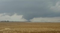
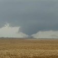
January 22nd-25th Winter Storm Potential
Radtechwxman replied to Thundersnow12's topic in Lakes/Ohio Valley
Man Rockford is in the sweet spot tonight in a training heavy band -
January 22nd-25th Winter Storm Potential
Radtechwxman replied to Thundersnow12's topic in Lakes/Ohio Valley
Well the last hurrah of this system sure went to crap. For such a pretty system on water vapor, it definitely isn't living up to how it looks. Lol. Lack of cold air ftw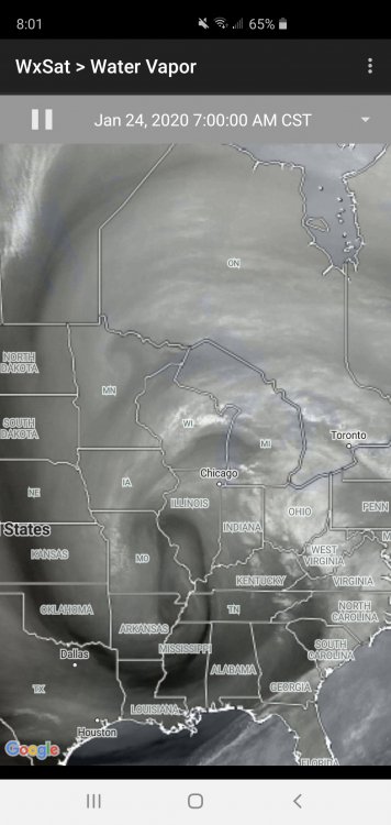
-
January 22nd-25th Winter Storm Potential
Radtechwxman replied to Thundersnow12's topic in Lakes/Ohio Valley
None of the models this morning are initializing well this morning with current low strength and placement. Most of them have a very broad 1012mb low over central IL and as of 1331z there's a 1009mb low just west of STL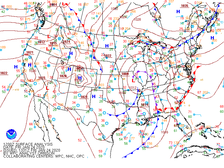
-
January 22nd-25th Winter Storm Potential
Radtechwxman replied to Thundersnow12's topic in Lakes/Ohio Valley
Ready to punt this sloppy mess of a storm. What happened to real winter storms? Seems like this last part is pushing more and more ne on model runs -
January 22nd-25th Winter Storm Potential
Radtechwxman replied to Thundersnow12's topic in Lakes/Ohio Valley
Finally ripping snow here. Nice fat flakes. But doesn't look like this will last super long tonight -
January 22nd-25th Winter Storm Potential
Radtechwxman replied to Thundersnow12's topic in Lakes/Ohio Valley
Same thing here. Pretty uneventful so far. Feel like Fri night into Sat will be best here -
January 22nd-25th Winter Storm Potential
Radtechwxman replied to Thundersnow12's topic in Lakes/Ohio Valley
I'm just surprised snowflakes are so tiny. I think my marginal temp now isn't helping. Snow barely accumulating -
January 22nd-25th Winter Storm Potential
Radtechwxman replied to Thundersnow12's topic in Lakes/Ohio Valley
Snow returns seem to be drying out in Peoria area. Seems like that band is struggling to lift north as well. Flakes are like pixie dust so far -
January 22nd-25th Winter Storm Potential
Radtechwxman replied to Thundersnow12's topic in Lakes/Ohio Valley
On temperatures? I'm thinking it's advancing the rain snow line west too quickly -
January 22nd-25th Winter Storm Potential
Radtechwxman replied to Thundersnow12's topic in Lakes/Ohio Valley
My thoughts exactly. And being near rain-snow line is a good sweet spot if you stay on snow side. Lol -
January 22nd-25th Winter Storm Potential
Radtechwxman replied to Thundersnow12's topic in Lakes/Ohio Valley
I know you're close to where I am. What do you think of hrrr bringing the rain snow line as west as the IL River? I think it could come close but sure as west as hrrr/rap show it -
January 22nd-25th Winter Storm Potential
Radtechwxman replied to Thundersnow12's topic in Lakes/Ohio Valley
Utter trash model. Literally shows rain here from tomorrow afternoon through the rest of the event. Makes no sense. I do believe there will be rain at times but there will definitely be snow at night -
January 22nd-25th Winter Storm Potential
Radtechwxman replied to Thundersnow12's topic in Lakes/Ohio Valley
Just nam is showing this current wave being more robust than it currently is so has me wondering if it is right on a more robust 2nd wave than other models


