

Radtechwxman
-
Posts
2,481 -
Joined
-
Last visited
Content Type
Profiles
Blogs
Forums
American Weather
Media Demo
Store
Gallery
Everything posted by Radtechwxman
-

Winter 2025-26 Short Range Discussion
Radtechwxman replied to SchaumburgStormer's topic in Lakes/Ohio Valley
Was feeling good about that system but now 18z nam shifted way north -
Winter 2025-26 Medium/Long Range Discussion
Radtechwxman replied to michsnowfreak's topic in Lakes/Ohio Valley
Going to be another winter with I80 north crew constantly cashing in while us south barely miss out. Noticing all these nw systems bullseye me then shift north as we get closer. Bring back the south shift. -
Dec 6-7th (It's not a clipper) Clipper
Radtechwxman replied to Chicago Storm's topic in Lakes/Ohio Valley
If it stalls south of you, you are really going to see some good rates and big flakes from those nice reflectivities crossing the mixing line into the snow. -
Dec 6-7th (It's not a clipper) Clipper
Radtechwxman replied to Chicago Storm's topic in Lakes/Ohio Valley
Per CC, mixing line really pushing north towards DVN -
Dec 6-7th (It's not a clipper) Clipper
Radtechwxman replied to Chicago Storm's topic in Lakes/Ohio Valley
Sleet/freezing rain/snow mixture here. Gunna b buried -
Nov 28-30th Post Turkey Day Winter Storm
Radtechwxman replied to Chicago Storm's topic in Lakes/Ohio Valley
It has compacted so much here hard to tell. I'm right by Alta and saw a 6in report there. I did just notice that cutoff for that was just before 5. We still had some more snow after then. Not much but some. Definitely curious to see an updated map once more totals come in. But still guessing there will be lower totals in this area. We didn't get much from overnight and snow this morning was not of good quality. Wasn't till banding moved in and finally got some bigger flakes. -
Nov 28-30th Post Turkey Day Winter Storm
Radtechwxman replied to Chicago Storm's topic in Lakes/Ohio Valley
This is comical. Guess who is in middle of that big dropout in totals? Me. Largely missed a lot of the banding and convective snow south and up north got into the waa snow more than here last night. This is better than anything last winter but when your expectations are for bigger totals, color me disappointed with this one.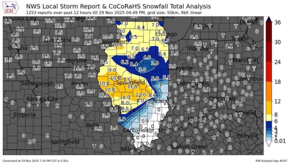
-
Nov 28-30th Post Turkey Day Winter Storm
Radtechwxman replied to Chicago Storm's topic in Lakes/Ohio Valley
Snow going to be ending within next hr or so here. Hours ahead of schedule. Idt I been so disappointed in a storm in a long time. Especially when all the models and nws were forecasting big totals. Congrats to all that scored big. -
Nov 28-30th Post Turkey Day Winter Storm
Radtechwxman replied to Chicago Storm's topic in Lakes/Ohio Valley
Snow looks like it's going to end early here at least. This definitely was an underperformer for me. Was supposed to get 8-12in. Idk if I will even hit that range. Snow quality was a killer early on then all this good banding really hammered I72 south of me. Looking at radar the system seems to be moving very fast. -
Nov 28-30th Post Turkey Day Winter Storm
Radtechwxman replied to Chicago Storm's topic in Lakes/Ohio Valley
Springfield getting demolished by very heavy snow and some thunder. I72 going to end up being a jackpot zone. I was not expecting that. -
Nov 28-30th Post Turkey Day Winter Storm
Radtechwxman replied to Chicago Storm's topic in Lakes/Ohio Valley
That was my issue through the morning. Very poor flake quality. Like pixie dust. Finally getting quality snow now. Thinking I may be on lower end of what was forecasted here though. Kind of feel like precip may move out sooner than forecasted. -
Nov 28-30th Post Turkey Day Winter Storm
Radtechwxman replied to Chicago Storm's topic in Lakes/Ohio Valley
Yeah that dry pocket worries me a bit. My snow im in is on eastern fringes of that. Hoping it doesn't creep east and hoping it fills in more. Flake size has been pretty small so far. -
Nov 28-30th Post Turkey Day Winter Storm
Radtechwxman replied to Chicago Storm's topic in Lakes/Ohio Valley
Im a little concerned about this dry slot in northern MO. All that heavy precip by STL seems like it may skirt south of me. Hrrr suggests things will fill in later. We shall see -
Nov 28-30th Post Turkey Day Winter Storm
Radtechwxman replied to Chicago Storm's topic in Lakes/Ohio Valley
I hope the radar really blossoms and fills in like models are suggesting. Trough seems to be approaching western NE. Isentropric lift should start increasing next few hours. -
Nov 28-30th Post Turkey Day Winter Storm
Radtechwxman replied to Chicago Storm's topic in Lakes/Ohio Valley
Watch it be right. Lol. I hope this precip shield fills in south like hrrr shows later. Right now main waa band setting up pretty north in Iowa. Always nail biting watching these evolve. -
Nov 28-30th Post Turkey Day Winter Storm
Radtechwxman replied to Chicago Storm's topic in Lakes/Ohio Valley
I would love 21z rap to verify please -
Nov 28-30th Post Turkey Day Winter Storm
Radtechwxman replied to Chicago Storm's topic in Lakes/Ohio Valley
18z wasn't as nice on nam's as it was on 12z for here. Im so close to being in that jackpot zone. Still will be a solid storm and will beat anything I got last year by a long shot. But man a slight shift south would be nice. Ha -
Nov 28-30th Post Turkey Day Winter Storm
Radtechwxman replied to Chicago Storm's topic in Lakes/Ohio Valley
Must be nice. Lol. Y'all really get spoiled up there. Can't tell you last time we got double digits snow here. -
Nov 28-30th Post Turkey Day Winter Storm
Radtechwxman replied to Chicago Storm's topic in Lakes/Ohio Valley
Yeah the early morning through mid to possibly late afternoon look good here. Probably several hours of solid rates. But I would be shocked with a low track that north if we dont mix or switchover at some point. But good thing is here looks to happen towards end of the event when most of our accumulation is done already. This system doesn't have much of a deformation zone. -
Nov 28-30th Post Turkey Day Winter Storm
Radtechwxman replied to Chicago Storm's topic in Lakes/Ohio Valley
I wish I was bit more north for this one. Still worried about mixing here. Definitely going to miss the jackpot zone but still could get a solid hit. But man it's been forever since we had double digits here. -
Nov 28-30th Post Turkey Day Winter Storm
Radtechwxman replied to Chicago Storm's topic in Lakes/Ohio Valley
Something that should probably be used for this event in a lot of areas is snow depth to see a more realistic depiction of what you may measure on ground. Kuchera and 10:1 maps aren't accounting for the compaction and melting from this very wet snow that will likely occur and are probably overinflated. Yes 8-10in may fall but may not reflect on ground after melting and compaction. -
Nov 28-30th Post Turkey Day Winter Storm
Radtechwxman replied to Chicago Storm's topic in Lakes/Ohio Valley
Definitely worried about how north some hi res guidance is. Especially the hrrr/rap. It still has decent totals here but question snow quality especially in the latter part of the storm as low passes close or over. Hrrr/rap drag the mixing line north of me. Gfs/euro/nam keep it south. Tomorrow is the day to watch for trends. Hoping this doesn't start a north trend now. I think QC up to Chicago really going to cash in but a little nervous down here on I74 corridor. -
Nov 28-30th Post Turkey Day Winter Storm
Radtechwxman replied to Chicago Storm's topic in Lakes/Ohio Valley
Yeah it definitely is. I wouldn’t want it anymore north than that. Hugs that mixing line right against me. Oof. My biggest worry is the marginal temps and ratios during day Sat. If rates are high enough it will help mitigate it somewhat but I do anticipate some level of melting and compaction. Hoping that warm nose can stay south enough to avoid a changeover. But that sfc low does get pretty north. -
Nov 28-30th Post Turkey Day Winter Storm
Radtechwxman replied to Chicago Storm's topic in Lakes/Ohio Valley
Yeah I think lower ratios and temps may keep snow totals in check. If we had colder air would be different story -
Nov 28-30th Post Turkey Day Winter Storm
Radtechwxman replied to Chicago Storm's topic in Lakes/Ohio Valley
0z gfs seems to be wanting to speed up the system imo. Definitely moving out quicker than 18z and definitely faster than other models It wasn't too drastically different but definitely nervous on that trend starting


