Radtechwxman
-
Posts
2,477 -
Joined
-
Last visited
Content Type
Profiles
Blogs
Forums
American Weather
Media Demo
Store
Gallery
Everything posted by Radtechwxman
-

December 11th-14th Double Banger Clippers
Radtechwxman replied to Jackstraw's topic in Lakes/Ohio Valley
That weenie band just south of DVN going to miss you? -
December 11th-14th Double Banger Clippers
Radtechwxman replied to Jackstraw's topic in Lakes/Ohio Valley
I would love 12z hrrr to verify. But nam has me a little nervous on a south shift. Has heavier swath south. -
December 11th-14th Double Banger Clippers
Radtechwxman replied to Jackstraw's topic in Lakes/Ohio Valley
Im definitely worried about another south trend. 0z euro and 0z nam's still look solid for you. Gfs was the most south. Hrrr/rap decently north as well but they also were night before this current event. -
December 11th-14th Double Banger Clippers
Radtechwxman replied to Jackstraw's topic in Lakes/Ohio Valley
Got into a nice weenie band tonight. Was dumping. Heaviest ended up to my south where my persistent banding was but I think I should manage to get in the 2-3in range. Hoping Sat will be more spread the wealth.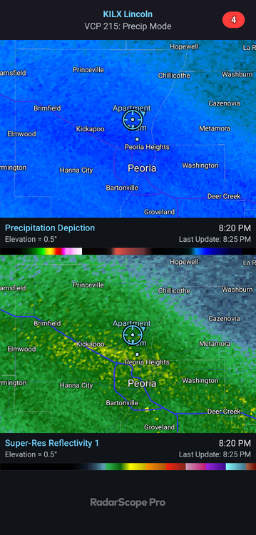
-
Winter 2025-26 Short Range Discussion
Radtechwxman replied to SchaumburgStormer's topic in Lakes/Ohio Valley
Nice unexpected weenie band here now. Dumping nice dendritic snow.
-
December 11th-14th Double Banger Clippers
Radtechwxman replied to Jackstraw's topic in Lakes/Ohio Valley
I admire your commitment -
December 11th-14th Double Banger Clippers
Radtechwxman replied to Jackstraw's topic in Lakes/Ohio Valley
Im honestly nervous about my area. Looks good now but so did my area for today days ago and look how much it shifted south. With more potential phasing hoping this one can be more north. -
Winter 2025-26 Short Range Discussion
Radtechwxman replied to SchaumburgStormer's topic in Lakes/Ohio Valley
Brutal cutoff. Band has stalled barely to my wsw. Will be lucky to see 1-2in probably. This is painful -
Winter 2025-26 Medium/Long Range Discussion
Radtechwxman replied to michsnowfreak's topic in Lakes/Ohio Valley
Hoping it doesn't follow baroclinic zone put down by today's snow and more so the incoming temp gradient with the arctic front. ILX seems to think it will follow snow swath of today's system and be more south. Models right now disagree. But obviously could change. -
Winter 2025-26 Medium/Long Range Discussion
Radtechwxman replied to michsnowfreak's topic in Lakes/Ohio Valley
Sat snow seems more north on runs today but guessing that will shift south like today's clipper did -
Winter 2025-26 Short Range Discussion
Radtechwxman replied to SchaumburgStormer's topic in Lakes/Ohio Valley
Not looking like it anymore. Keeps shifting south and less qpf on morning runs. At this point 2in is probably generous here. Maybe 3in if we get into good banding. Hoping Sat can pan out better cuz this one has really downtrended. -
Winter 2025-26 Short Range Discussion
Radtechwxman replied to SchaumburgStormer's topic in Lakes/Ohio Valley
Just making an observation. Lol. I find it amusing how all over the place guidance is still. 0z nam south. At this point anyone is fair game -
Winter 2025-26 Short Range Discussion
Radtechwxman replied to SchaumburgStormer's topic in Lakes/Ohio Valley
0z hrrr not backing down. It's either out to lunch or going to pull a big win being the model that was right -
Winter 2025-26 Short Range Discussion
Radtechwxman replied to SchaumburgStormer's topic in Lakes/Ohio Valley
Hoping tomorrow pans out here. Sat seems to keep trending more south and weaker each run. At least on gfs. -
Winter 2025-26 Short Range Discussion
Radtechwxman replied to SchaumburgStormer's topic in Lakes/Ohio Valley
Live and die by hrrr. Usually dont give it any credibility till day of event Clippers are a nightmare to forecast. Seems like a lot of last second shifts with these. Also could be a relatively narrow corridor of frontogenic banding with areas outside getting more of a pixie dust snow. Definitely not spread the wealth. Sat has a little bit better coverage. -
Winter 2025-26 Short Range Discussion
Radtechwxman replied to SchaumburgStormer's topic in Lakes/Ohio Valley
And cams ended up being right. 18z nam more south than hrrr but more north of globals. So might be a good compromise. Hrrr definitely the most north. But would be par for course to get missed north Thurs and missed south Sat. -
Winter 2025-26 Short Range Discussion
Radtechwxman replied to SchaumburgStormer's topic in Lakes/Ohio Valley
If hrrr is right N IL scores again and I will be on southern edge. Cams definitely more north and globals more south. Crazy how much variability there still is the day before. -
Winter 2025-26 Short Range Discussion
Radtechwxman replied to SchaumburgStormer's topic in Lakes/Ohio Valley
Im sure it will find a way to shift north or south of me still. The dome is strong. Ha. I feel most optimistic about Thurs. Sat I feel might end up even more south unfortunately. 12z gfs has me on northern edge. We shall see. Definitely a notable south trend. -
Winter 2025-26 Medium/Long Range Discussion
Radtechwxman replied to michsnowfreak's topic in Lakes/Ohio Valley
Probably going to see a lot of north and south wobbles. I dont like where I sit currently. Cutoff will be sharp and frontogenic bands always end up narrower than expected with brutal cutoff on either side. -
Winter 2025-26 Short Range Discussion
Radtechwxman replied to SchaumburgStormer's topic in Lakes/Ohio Valley
Well pattern lately been favoring north shifts and generally I80 north so maybe not. We shall see. Wish I could lock in gfs. Ha -
Winter 2025-26 Short Range Discussion
Radtechwxman replied to SchaumburgStormer's topic in Lakes/Ohio Valley
Big double thumbs down on this. I kind of hate nw flow. Because I feel these tend to setup up north of here. Just cold and dry makes me wanna -
Winter 2025-26 Short Range Discussion
Radtechwxman replied to SchaumburgStormer's topic in Lakes/Ohio Valley
Was feeling good about that system but now 18z nam shifted way north -
Winter 2025-26 Medium/Long Range Discussion
Radtechwxman replied to michsnowfreak's topic in Lakes/Ohio Valley
Going to be another winter with I80 north crew constantly cashing in while us south barely miss out. Noticing all these nw systems bullseye me then shift north as we get closer. Bring back the south shift. -
Dec 6-7th (It's not a clipper) Clipper
Radtechwxman replied to Chicago Storm's topic in Lakes/Ohio Valley
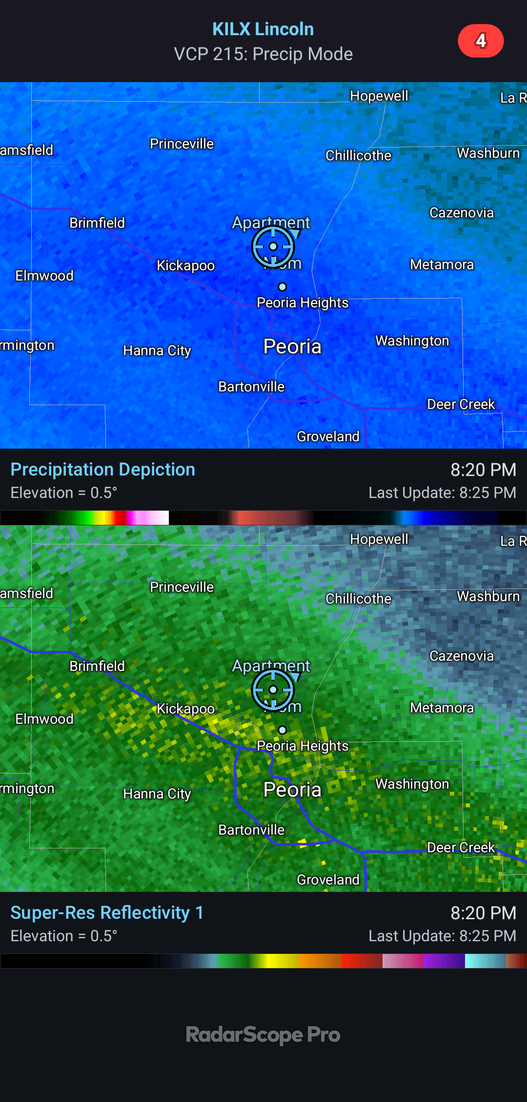
If it stalls south of you, you are really going to see some good rates and big flakes from those nice reflectivities crossing the mixing line into the snow. -
Dec 6-7th (It's not a clipper) Clipper
Radtechwxman replied to Chicago Storm's topic in Lakes/Ohio Valley
Per CC, mixing line really pushing north towards DVN