

cyclone77
-
Posts
18,865 -
Joined
-
Last visited
Content Type
Profiles
Blogs
Forums
American Weather
Media Demo
Store
Gallery
Everything posted by cyclone77
-
I could be down for a ring of fire pattern. Tis the season is the reason.
-
The dry air allowed us to drop to 49 early this morning. Back up to 86 this afternoon.
-
Extremely dry air advected in from the northeast this evening. Have had dews as low as 33.
-
I'm going through Canadian smoke withdrawal.
-
Ending the month with a bang. Getting some sprinkles from time to time. Will finish May with 1.77".
-
51 this morning, 88 this afternoon. Wish we could keep these low 50 degree dews.
-
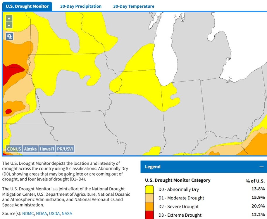
This is one for Annie Lennox's other song ♪ here comes the drought again ♪
-
Keeping the lawn, but I don't put down any chemicals or anything or water it. The birds love the well kept lawn. Out here in the sticks if you have an overgrown landscape you will have all kinds of creatures trying to get into your home. I did plant plenty of native trees all throughout the yard.
-
First 90 degree day of the year here today with 93. Sterling hit 92, DVN 90. EDIT: Sterling hit 93 as well between the hourly obs.
-
Gonna get a nice long break from mowing the lawn.
-
Guess this should lock in IL for the title for most tors this year then.
-
86 here today, but with a nice breeze and upper 40s dews it was pretty nice. Won't be long and we'll be battling the 80+ degree dews. The corn is a growin'...
-
Got grazed here on the extreme west side of the overnight event, and picked up a much appreciated 0.69". None of the models showed it this far west so a very nice surprise indeed.
-
July will be rockin'
-
Through end of the month. Gotta love it.
-
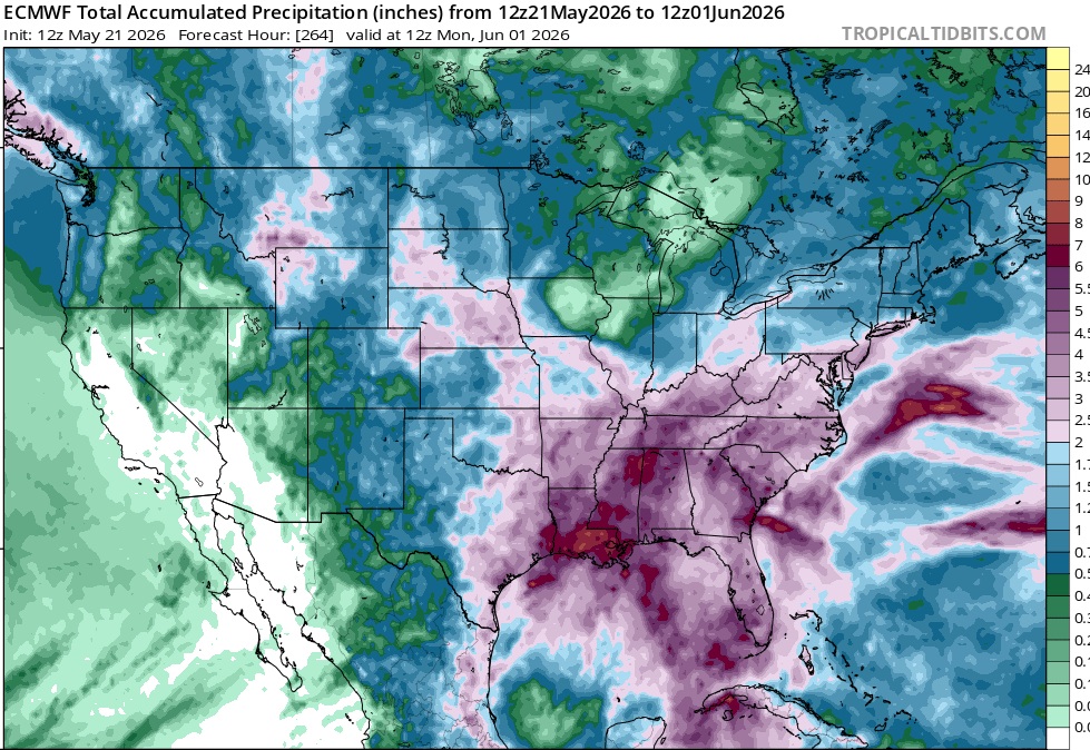
0.22" early this morning to bring the 4-day system total to 0.81". Seems like we have a yo-yo going on here with the moisture. Slammed in April with 7+ inches, this month will likely end up around 1 inch. Hopefully in June we can get another 7-8" to make up for May.
-
Looks like tonight will be night number 4 with storms dying out before reaching here. Hopefully meaningful rains return in June.
-
Just 0.17" here early this morning. 0.59" 3 day total.
-
Yeah just a bad overall setup for our areas. Several days of action in the Missouri Valley, and then it skips over and impacts areas east for Tuesday.
-
Or not lol.
-
Didn't quite make it. 0.42" Friday night and 0.00" last night. Another chance at dying convection tomorrow morning.
-
50mph southeasterlies on the north side of the southeast Iowa anvil rain. Don't think it's a wake low, seems like the southeasterly surface winds are being enhanced by the MCS somehow.
-
MSP area is gonna get smacked pretty hard tomorrow evening.
-
Looks like back to back nights of decaying Iowa convection tonight/tomorrow night. Hoping for a half inch between the two nights.
-
The HRDPS is the best short term model IMO. Always seems to have the best handle on convection evolution.


