

cyclone77
-
Posts
18,904 -
Joined
-
Last visited
Content Type
Profiles
Blogs
Forums
American Weather
Media Demo
Store
Gallery
Everything posted by cyclone77
-
Ready 2 frostbite
-

Winter 2025-26 Medium/Long Range Discussion
cyclone77 replied to michsnowfreak's topic in Lakes/Ohio Valley
Probably for everyone other than Michigan if it's like the rest of the winter. -
Tomorrow starts the new SPC outlooks. Hopefully Broyles kicks it off. He's been doing the longer range ones lately.
-
Snow missed just south last night. MLI now down -10.1" for the season.
-
Only 64 more model cycles left to see if this comes to fruition.
-
Looking forward to it.
-
Good question. I can't remember why he disappeared.
-
Nice band of 5-8" of snow over southern MN into southwest WI today. Not too far from Daddylonglegs if he still lives in La Crosse.
-
Well today closes out what was a highly active month of February. MLI finishes with a T of precip, and DVN had 0.05". Got lucky here and got drowned with 0.22" for the month. Let's see how we do in March.
-
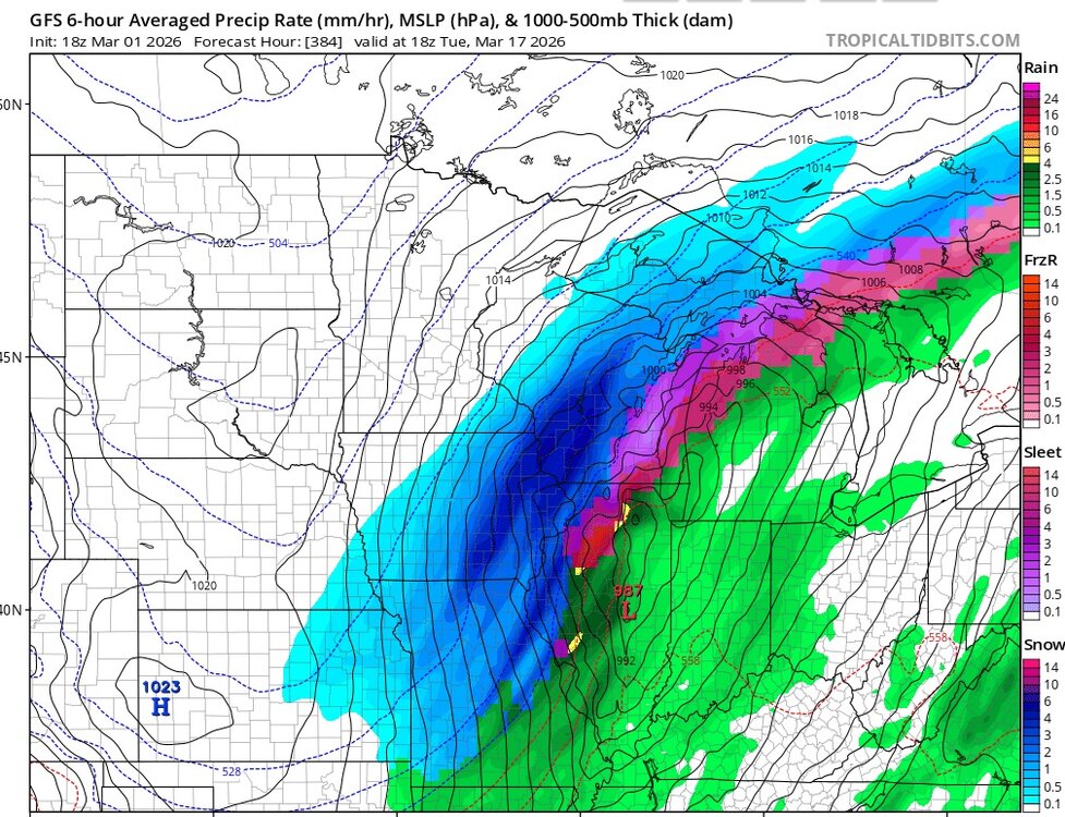
Already starting to trend drier as we get closer, with the heavier rains shifting southeast. Hope we can still squeeze a half inch out of this over the next 2 weeks.
-
72 at MLI, 71 at DVN today. Hit 69 here.
-
Pretty sure that map will end up being quite correct.
-
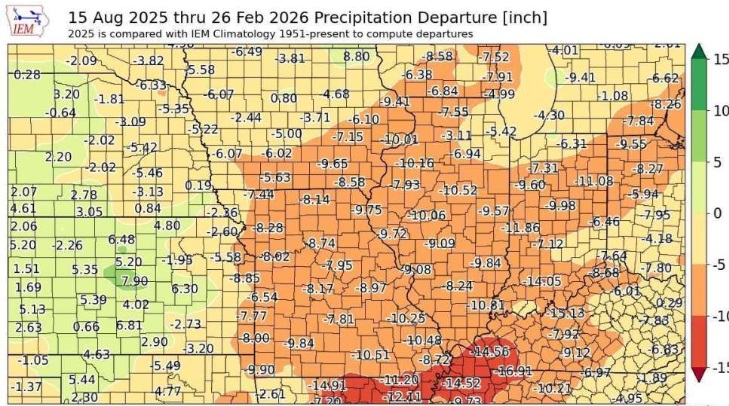
Yeah we need rains like what's being modeled for sure. Funny we're down 10 inches of precip since last summer, but still just classified as "abnormally dry" on the drought index lol.
-
Winter 2025-26 Medium/Long Range Discussion
cyclone77 replied to michsnowfreak's topic in Lakes/Ohio Valley
-
Nice to see wet systems showing up finally in the medium range. Hope we can get them into the short range without them drying up.
-
Can't go any better than a D without a single grass topper event after Dec 7th. Would easily be F- yet again without the awesome start to winter.
-
Not even a T here lol. Still top 5 event for Feb tho. MLI managed to squeeze out 0.1". Brings them up to 0.2" for the month, but still stuck at a T for precip total.
-
Tomorrow waiting for the snow's arrival.
-
Winter 2025-26 Medium/Long Range Discussion
cyclone77 replied to michsnowfreak's topic in Lakes/Ohio Valley
Nailed it. -
Feb 1-2 2011.
-
Reminds me of your vids near the lake during GHD1.
-
If the Roger Smith triple phaser ever takes place though it will make GHD1 look like a snow shower.
-
We'll always have November 30th.
-
I don't remember it ever saying heavy snow on the extended, but whenever it just said snow you knew there was a shot at something legit.
-
Always nice when tracking a system 3 days away and wondering if it will even exist.


