LVblizzard
-
Posts
4,928 -
Joined
-
Last visited
Content Type
Profiles
Blogs
Forums
American Weather
Media Demo
Store
Gallery
Everything posted by LVblizzard
-
E PA/NJ/DE Spring 2026 Obs/Discussion
LVblizzard replied to PhiEaglesfan712's topic in Philadelphia Region
The snow pile at the end of my neighbor's driveway has finally melted. All that's left is the piles in parking lots. -
E PA/NJ/DE Spring 2026 Obs/Discussion
LVblizzard replied to PhiEaglesfan712's topic in Philadelphia Region
Looks like it did! Seeing some lightning to the north for the first thunderstorm of the year! -
E PA/NJ/DE Spring 2026 Obs/Discussion
LVblizzard replied to PhiEaglesfan712's topic in Philadelphia Region
Snowpack is officially gone. There’s a shady spot in my yard that still had some remnants left. Today’s rain washed that away. All that’s left now is the pile at the end of my driveway. Overall a very impressive duration, I had snow on the ground there for a month and a half straight. -
E PA/NJ/DE Winter 2025-26 Obs/Discussion
LVblizzard replied to LVblizzard's topic in Philadelphia Region
0z mesos are way less amped with Sunday’s little wave which makes it cold enough for snow down to I-78. Gonna be interesting to see if that trend continues. -
E PA/NJ/DE Winter 2025-26 Obs/Discussion
LVblizzard replied to LVblizzard's topic in Philadelphia Region
I swear this stuff always happens at the exact moment we all get sick of the snow and cold. -
E PA/NJ/DE Spring 2026 Obs/Discussion
LVblizzard replied to PhiEaglesfan712's topic in Philadelphia Region
Major agreement for this on the globals and ensembles now. It looks like we could have an extended period of 60s and 70s starting late next week. -
E PA/NJ/DE Winter 2025-26 Obs/Discussion
LVblizzard replied to LVblizzard's topic in Philadelphia Region
Another failure by the models here. They all had about an inch last night pretty consistently for days. We got nothing but virga and maybe a flurry. This is honestly just as frustrating as a bigger bust because it seems like such a simple setup that just never materialized for some reason. -
E PA/NJ/DE Winter 2025-26 Obs/Discussion
LVblizzard replied to LVblizzard's topic in Philadelphia Region
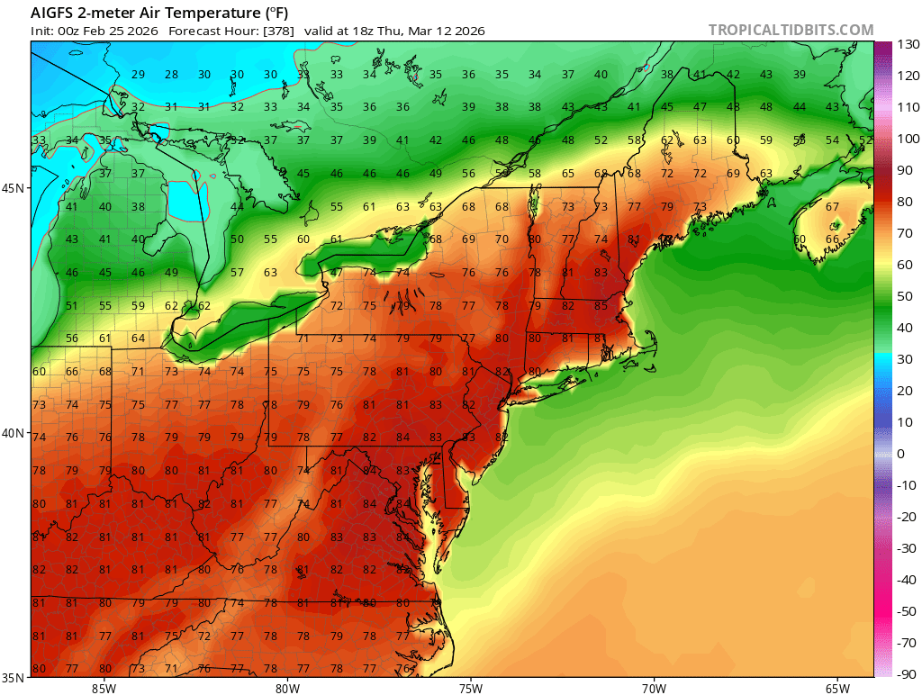
AI GFS would certainly be something if it verified.
-
E PA/NJ/DE Winter 2025-26 Obs/Discussion
LVblizzard replied to LVblizzard's topic in Philadelphia Region
Well that Thursday threat disappeared quickly. It was never going to be anything big but a little burst of snow would have been nice. Crazy to think some models had it in upstate NY two days ago…now it’s suppressed to the south. -
E PA/NJ/DE Winter 2025-26 Obs/Discussion
LVblizzard replied to LVblizzard's topic in Philadelphia Region
Thursday’s storm keeps trending towards a miss. I’ll have to enjoy the inch or so I get tonight, even if the sun angle causes it to melt immediately tomorrow. -
"Don’t do it" 2026 Blizzard obs, updates and pictures.
LVblizzard replied to Ginx snewx's topic in New England
Even when I say I'm sick of winter and ready for warmer weather, the minute that late March/early April threat comes around I'm watching the models and cheering on snow just like in the middle of winter. -
Snow is melting quick here. A third of it is gone already.
-
I think the problem is that they rely too heavily on the NBM which has far more mesos/SREF data ingested into it than global model data. The same thing happened a month ago in the DC area, the NBM kept giving them a foot when it was clear they would be mostly sleet.
-
Ended with about 6 inches here. Not a huge bust on the level of Boxing Day or Juno, but it’s definitely a “what could have been” storm.
-
Light snow here, about 5 inches. Looks like some banding will find its way here overnight but it doesn’t look like it’ll be anything special. Not worth staying up for it, I’ll have to find out how much additional snow we get in the morning.
-
What a massive fail by the RGEM. It’s going to bust low everywhere.
-
A lot of the short range models show a lull overnight followed by more in the morning. All depends on how the low tracks.
-
They really want an additional 4-12" here? 4", sure...no way we get a foot though.
-
Your total seems awfully low...I have 4" and there are multiple reports exceeding that in the area.
-
Snow has lightened up here but it's still steady. About 4 inches so far. Looks like another heavier band is trying to make its way here.
-
Based on the info drought guy has given us I think he lives on the mountain south of Macungie. This is the type of storm where he should get a couple inches more than us just because of terrain enhanced snow.
-
A little north of Macungie, close to Dorney Park.
-
Made it into that heavy band, at least for the moment. 2 inches on the ground. Less than 2 more inches and we exceed the RGEM total!
-
I’ve seen Boxing Day floated as an analog for this. I’m already very close to my total from that storm with moderate snow falling. That band to the south looks nice…hopefully it makes it up this way.
-
Getting some stickage now, roads are still just wet though.