
USCAPEWEATHERAF
-
Posts
8,736 -
Joined
-
Last visited
Content Type
Profiles
Blogs
Forums
American Weather
Media Demo
Store
Gallery
Everything posted by USCAPEWEATHERAF
-
Perhaps why they found 155-knot surface winds and the upper level winds were much weaker
-
That is not a question you can answer!
-
How is this a third world country issue? Please explain?
-
VDM says it strengthened to 135 knots, 2-knots to category five
-
Mitch did not hit this same area on this same path as Eta. Mitch went north of Honduras and then turned south and made landfall in central north coast of Honduras and then meandered around.
-
I thought IRMA was very picturesque
-
Wilma was a great looking hurricane sub890mb
-
wow
-
Already at hurricane force flight level winds
-
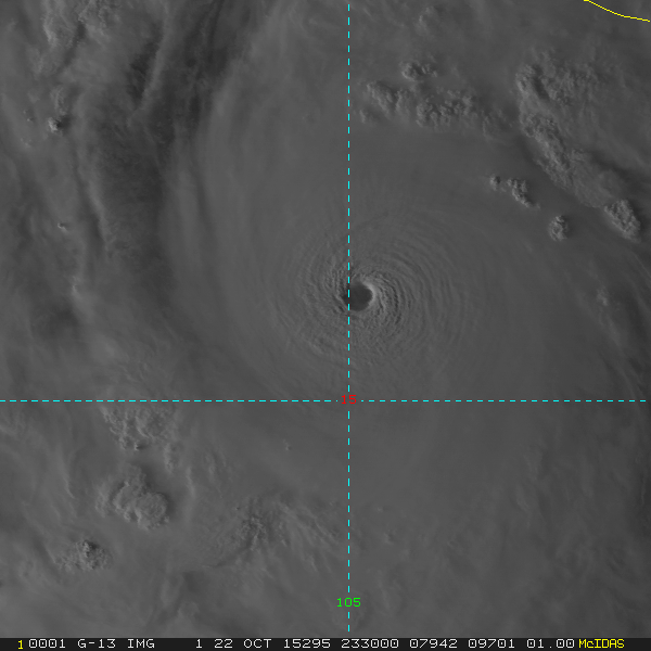
Eta looks the best and symmetrical in those three pictures
-
Yeah the recon plane is inside the CDO now, within 1.0 degree of latitude within the center.
-
Wow, this is perhaps stronger than Patricia if that is a measurement!
-
It is crazy, this storm is defying our measurements!
-
This is spectacularly dangerous and concerning.
-
Last minute change: 880mb pressure and 175-knot sustained winds!
-
It is already at 934mb
-
Major Hurricane ETA has reached 150mph winds as of the 7pm EST update of the NHC November 2nd, 2020 She is likely a category five once recon arrives
-
Can I still join in on the guesses? 896mb/165-knots
-
One was lost in the Western Pacific too
-
Its the Super Hercules, WC-130 J
-
The WC-130 J Hercules known as the Super Hercules was an upgrade over the original C-130 which the Coast Guard uses now. The C-130 J is also used for other operational procedures in the AF, just not the 53rd WRS
-
Its a four turboprop engine plane, all 4000 HP for a total of 16000 hp
-
No its the upgrade, the WC-130 J Hercules
-
 Again, the fall season still wants to remain warm across the eastern CONUS. Right now, the pattern to Wednesday resembles a troughy but zonal pattern aloft where westerlies remain in control with several troughs moving through the region before the region warms significantly as pattern amplifies into a ridging in the East and troughing in the west pattern. This is supported by the teleconnections across North America of a strong +NAO/-PNA/+AO pattern. The only semblance towards a more average pattern temperature wise is with the AO heading neutral by day 15. Right now, there are no true signs that point to a renewed cold regime in the next two weeks. Soak up the warmth for the next few weeks. Sun will continue to set earlier each day until the first day of calendar winter season.
 -
Virtual GTG This Weekend...Any Interest?
USCAPEWEATHERAF replied to Cold Miser's topic in New England
The studs and stars of the first real zoom video meeting of the 2020-2021 winter season.


