
USCAPEWEATHERAF
-
Posts
8,736 -
Joined
-
Last visited
Content Type
Profiles
Blogs
Forums
American Weather
Media Demo
Store
Gallery
Everything posted by USCAPEWEATHERAF
-
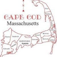 From HYA eastward snow becomes enhanced by northerly surface winds and brings some snow accumulations to the region from Hyannis to Provincetown tonight after 6 pm EST. Models show some accumulation, maybe about 1-2" of snow.
 -
Today we will experience extreme weather at its finest. Severe flash freeze is setting up to enter the region as soon as later this morning, when temperatures sweep west to east with a 20-30F temperature change in the next 18-20 hours. It will happen suddenly with the change of the winds vector. AS the warm balmy 50+ degree southwesterly winds will change to a violent northwest cold dry bone chilling cold arctic air howling over 30mph. Rain will change to snow and temps will bottom out in the lower 20s. BRRRR!!!!!!!!!Current MESO OBS
-
This will be my first and official snowfall map for the early week snowstorm.
-
North American Pattern details
USCAPEWEATHERAF posted a blog entry in Snowfall Updates and Forecasts 2019-2020 and beyond!
Strong anomalously cold air heading towards the CONUS, eastern 2/3rds, east of the Rockies, Very warm air across SW CONUS, including the states of CA, NV and NM. Fire dangers will continue for the areas impacted to this date. Very little mountain snow/rain for CA, OR and WA. MT to Great Lakes and Northeastern US will see above normal snowfall, perhaps quite intense snowfalls in the coming weeks November will bring snow and cold for most of the eastern CONUS Alaska should remain rather dry and mild, I wouldn't say warm Big storm threats for snow along the I-95 corridor and the immediate coastline of the Mid-Atlantic and New England regions will being next week, Monday-Wednesday Pattern now is a combination of a -NAO/-AO/+PNA regime Upper level pattern establishing itself now will favor prolonged sustained cold air and snow potentials due to anomalous ridging in Alaska and the PNA regions, and Greenland block developing in the North Atlantic Polar Regions Below are the maps of the pattern present and the snowfall and storm tracks anticipated for the next 48-60 days. -
With my illustrations below to show you why we can expect a cold month of November, I will leave you this post.
-
While models decide their differences in the next day or so with the incoming precipitation threats, the one thing the pattern is adjusting to show is the appearance of arctic air masses invading the Northern 2/3rds of the CONUS. While large sustained +PNA is present, we will be getting some major league arctic air invading our region and the eastern 1/3rd of the country. While CA and the SW US bakes in record heat and fire weather, the MS Valley eastward will be experiencing the first cold winter snap of the fall season. While October snowfall wasn't the case this season, it appears we will not escape November without a few chances of snow. With such an arctic air mass in charge the coming weeks, we will see record highs and lows fall. Right now, get the winter gear in order, we will need it.
-
It is becoming increasingly clear, that the models are showing more confidence in an interior New England, mainly northwestern New England snowfall is going to happen later Thursday into Friday morning. The quick nature of the system, what the weather world calls a progressive storm, is something that won't be spectacular by any stretch of the imagination, but could have some moderate travel impacts where it does indeed snow and accumulate. The one thing that is blatantly obvious in the weather pattern developing now through November, is that there will be some amazingly cold air masses invading the region. These air masses are driven by the mid to upper levels of the atmosphere over North America that will be originating from the Polar regions, arctic in appearance. There are some very cold temperatures being printed out by the models, especially the GFS for Saturday this weekend and Tuesday of next week, indeed for CHH climate numbers, we could be as much as 10 to 20 F below normal both days. Low temperatures in those two days could be in the upper 20s with northeasterly winds aiding to the presence of ocean effect showers. Precipitation type unknown at this point and it is over 7 days away. Time will tell if CHH gets their first measurable snow then or not. For now, areas northwest of Worcester, MA will see some accumulating snowfall and I don't know how much just yet.
-
Here is the likely impacts from our potential winter storm on Friday morning.
-
Models are still undecided on the details as well as the synoptic scale pattern evolving the next 4-5 days across the Northeastern US. Residents should watch the evolving forecasts the next 36 hours across the area, but should not be alarmed, especially southeast of I-95 corridor.
-
An Early Season Winter Storm, too early to say!
USCAPEWEATHERAF posted a blog entry in Once a legend always a legend
Today, this morning in New England, Monday is a rather slow, unwelcoming day. Most New England Patriots fans are waking to an early sun rise, with the knowledge that their New England Patriots took a big loss on the chin from the Baltimore Ravens before their week 10 bye. With the knowledge that there are weaknesses on the team's defense and offense, we pay attention to the weather scene the next two weeks before another game is played against the Philadelphia Eagles. I awake this Monday morning, knowing that a potential winter storm is lurking in the day four window, and according to the 00z EURO run this morning, there might be a legit snow to the coast by day 9. However, that is both beside the point. Today, Monday, November 4th, 2019 is only four days away from a modeled interior snowstorm for New England. Possibility becomes likely when models begin to agree on the storm in the 3 1/2 day window and confidence begins to increase substantially with the three major global models in relative agreement, the EURO, GFS and UKMET models have the same event in the same location, with similar results. We should wait another 36 hours before we are more confident in any model and have the short range ensembles and the short range HI resolution guidance in the range necessary for a high confidence forecast. For now, the November 8th modeled event is just that, a potential and nothing more or less. Residents southeast of the I95 corridor in RI and SE MA should not worry too much about accumulating snowfall, for the most part if it snows at all it should melt. The sun angle, while getting lower, is not there yet, and the ground is too warm as well as the ocean to the northeast while cooling substantially faster than last year at this time, we are still in the low to mid 50s off the South Shore of Boston to Nantucket. The only shot is a cold screaming north wind that carries the very cold arctic air mass over the warmer waters. Right now, nothing supports snow in the area, Cape Cod residents who love snow, we need to wait. -
Patriots gameday forecast, November 3rd, 2019
USCAPEWEATHERAF posted a blog entry in Once a legend always a legend
In less than 24 hours, the Patriots are scheduled to play the Baltimore Ravens. The current weather forecast is quite pleasant for Baltimore area. Temperature expected to be in the mid-40s throughout the game, dew points in the lower 30s, with relative humidity in the dry zone of around 48 %. No precipitation is expected as there are no weather systems in the area for the game tomorrow. Frost could build throughout the game across grassy areas and colder surfaces. Winds should be a non-factor, as they will be variable and light nothing over 10 knots. I expect a rather lower scoring game, but Patriots come out covering, over 10 point win. -
Snow from a potential coastal storm is looking like a distinct potential, nothing serious or imminent, just a potential. Given the long term nature of the snow event possibility and given how volatile models can be run to run, we need to wait to see some resemblance of consistency start to mount up in the coming days. We just aren't there yet. Cold is coming and perhaps arctic in origin. That is as much a given as anything right now. Have fun this weekend, enjoy in the climate weather, near average to slightly below average with dry conditions. We will know when something decent is coming in the 3 day range.
-
Latest GFS and model consensus showing signs that winter is ready to make a return. Today will begin the cold pouring into the eastern CONUS. BY the end of the seven day forecast, next Friday, a coastal system is showing up on the models. However, I am not sold on this potential at this time. There is a lot of disagreement on the potential location and track and intensity of said storm. We will know more by the end of the weekend into the Monday timeframe of next week.
-
**Alert Level** (High), potential snowstorm impact in the next three days, high! Parts of the Denver region could see multiple feet of snow in the mountains and in the city region. Snowfall amounts of 10-30" is possible as the period ends 00z Wednesday, or Tuesday 8 pm EDT. Multiple model consensus shows a strong trough entering CA now and moving over the area by Monday afternoon into Tuesday. This will lead to leeward cyclogenesis to occur as the trough tilts more neutral. This will lead to an area of blossoming precipitation on the northwest side/cold side of the low pressure center. Impact will be expected in the high range. Heavy snow and strong winds could lead to blizzard conditions. Tuesday into Wednesday could see the heaviest snowfalls, over 12". This could lead to snow over Chicago, IL and become an intense storm that changes the pattern across the central and eastern CONUS. Updates to come in the next few days!SREFs show an all out huge snowstorm for Denver, CO
-
The Climate Prediction Center is more than 50/50 confident, precisely 55-60 % chance that neutral ENSO pattern will persist until Spring 2020. We are becoming more confident on an equal opportunity winter for above normal snowfall from PVD to BOS to Portland ME. I will have further updates first week into the first ten days of November.
-
Multiple model consensus suggests that the current evolving pattern for the Equatorial Pacific Ocean basin wide is favoring neutral-ENSO pattern. CPC suggests there is a more than 50/50 chance of a neutral ENSO persisting until Spring months of 2020. This should favor a strong winter favoring above normal snowfall for eastern to central New England with a below average temperature climate. Long range models suggest the pattern evolving this weekend will lead to a prolonged cold air mass. More will become present as we head into the first week of November.
-
Hello southern New Englanders, this evening update is about the latest guidance showing a potential pattern change storm erupting in the 5-10 day range. This storm signals the erupt change to a colder and maybe perhaps more stable pattern towards Halloween and the change into the month of November. Deep cold is on tap for after the next week. Stay Tuned! Winter is still around the corner.
-
Models in the long range, are beginning to show a winter like pattern beginning late OCT, sometime after the 27th. In the next two weeks of OCT, warm air is settling in after our mid-week miller B storm center offshore of MVY sometime WED night. Cold air will dump into the central Northern CONUS north of 40 north latitude.
-
The next four days present an unique challenge for weather forecasters. Models present a blocked upper-level pattern which ensues at the surface as well. A large ridge in Atlantic Canada will keep the coastal low pressure blocked at the surface and rather stalls or meanders off the coast near the New England storm benchmark location or 40N:70W. Winds will increase after 12z tomorrow into 12z Friday, they should peak between 55-70mph winds at the coastline between 12z Thursday and 12z Friday. Heavy rainfall over 5" should be a common number when this storm exits Saturday night/Sunday morning. Be prepared for a raw few days from I-95 corridor eastward will be the main region impacted from eastern CT to Eastern ME.
-
Cold Season weather today!
USCAPEWEATHERAF posted a blog entry in Snowfall Updates and Forecasts 2019-2020 and beyond!
Today radar imagery shows Ocean Effect precipitation is developing and falling over the Outer Arm of Cape Cod this early afternoon. Radar shows flow is out of the north to northwest with rather cooler air mass moving over the low 60 degree ocean waters over the bay. Sprinkles and a few misty periods have developed. Radar image below shows this well.https://weather.cod.edu/satrad/?parms=local-Rhode_Island-comp_radar-24-1-100-1&checked=map&colorbar=undefined -
Upcoming weather for New England!
USCAPEWEATHERAF posted a blog entry in Once a legend always a legend
Latest guidance and weather data suggests the rain that was impacting the region this morning is out of the way now, but cloud cover should stay in control for most of the morning into the early afternoon, before some clearing occurs as a strong Canadian High builds in from the northwest. Tomorrow looks dry and cool, with highs in the lower to middle 50s and lows near 45F. Sunday looks similar with perhaps a stronger and warmer return flow as the high shifts to the east with a rather nice rebound temp wise into the upper 50s and lower 60s and lows again in the mid to upper 40s. Frost is possible the next few days across the interior of New England and the mountains of the area. Monday will feature a warmer day than the weekend as a front approaches from western NY. Temperatures will return into the mid to upper 60s maybe some locations nearing the lower to mid 70s perhaps for the last time until March, unless a period of Indian Summer reaches that mark again this winter season. Perhaps the next time we see temperatures in the mid 70s will be late April early May 2020. Monday will feature warm temps, but the return of high altitude cirrus clouds and then thickening clouds towards sunset and temps lowering no more than 60F in the overnight hours before the cold front passes through late Tuesday morning. Temperatures will peak in the morning and then fall dramatically throughout the day into the lower 40s into Wednesday morning. Wednesday through Friday appear to be the middle 50s for highs and lower to middle 40s for lows until the weekend features potential for another cold front that will bring rain showers and colder air for the weekend into the early week. Stay Tuned! We will likely see subtle changes in the coming days to the ten day forecast. - JWN Productions! -
Attached is the guidelines for the different threat levels I will put in place for each snow event in the future from end of November through the first week of April 2020. Snowfall amounts and impacts forecast technique.docx
-
The Weather Channel - Naming List of Storm Names
USCAPEWEATHERAF posted a blog entry in Once a legend always a legend
List of names (TWC) issued for the 2019-2020 winter season: Aubrey - Bessie - Caleb - Dorothy - Ezekiel - Finley - Gage - Henry - Isaiah - Jacob - Kade - Lamont - Mabel - Nash - Odell - Pearl - Quincy - Ruth - Sadie - Thatcher - Upton - Veronica - Wyatt - Xandra - Yates - Zachariah -
First Signs of Winter showing up!
USCAPEWEATHERAF posted a blog entry in Snowfall Updates and Forecasts 2019-2020 and beyond!
Today, I have been sifting through the data and the guidance as of the 00z runs 10/3 and they are showing me the signs towards winter are upon us. New England weather is rather volatile the further we get from the summer and we get deeper into the season of Fall and then winter. As the holidays approach we are reminded how lucky we have been to live life as long as we have, and to have people who care about us in this world. As the holidays approach we are reminded of this constantly. As winter approaches abruptly and the only way Nature knows how, we get warning signs that the weather machine is ready to change gears and this is what I am seeing on the guidance this morning. There is rather strong agreement that a clipper will develop a secondary low off the coast of Cape Cod and Nantucket (ACK) as we head into the weekend. This system will carry a cold air mass on the north side and then northwest side and bring a change of temperatures to the region from the backside winds. Before that happens, we will experience spotty rain, until you are north of Concord, NH where rain will become more steady and then changeover to snow as one heads into the mountains of northern NH/VT/ME and the mountains of this region in the weekend. Saturday will be rather raw and spot showers at times, and then Sunday will be quite beautiful and rather chilly compared to what the last few days have given us. Also, another sign of the change in seasons is the rather rapid build-up of cold deep arctic air masses into northern Canada and then into the central and southern Canadian Prairies. This will begin to dive into the northern third of the US, above 40N from MT to ME as we head into the mid-month period and then the end of the month and beyond. Rather active weather pattern will begin to impact the US as multiple troughs will swing through the northern tier, this is rather common in neutral ENSO patterns. I will have another update after the 12z EURO if something changes in the guidance.