CoraopolisWx
-
Posts
2,960 -
Joined
-
Last visited
Content Type
Profiles
Blogs
Forums
American Weather
Media Demo
Store
Gallery
Everything posted by CoraopolisWx
-
Wtf. Gift card spam link.
-
I know it's been kinda rough for awhile, but hopefully your patience will be rewarded in November, even there on the west side. Also we tend to do better here in Pgh, when you folks on the west side do well. So I'll be rooting for y'all. lol
-
 No.That would've been nice though. Lol
 -
On a side note, is Kamikazees on 30 still open ? And if so, do they still do the topless (sometimes everything) bartending evening service. Went there with some co workers about 10 years ago, and it was interesting. LOL
-
I'm probably in the minority, but I like the forecast for the next 7 days. If I can't get a decent snowfall, it might as well be mild.
-
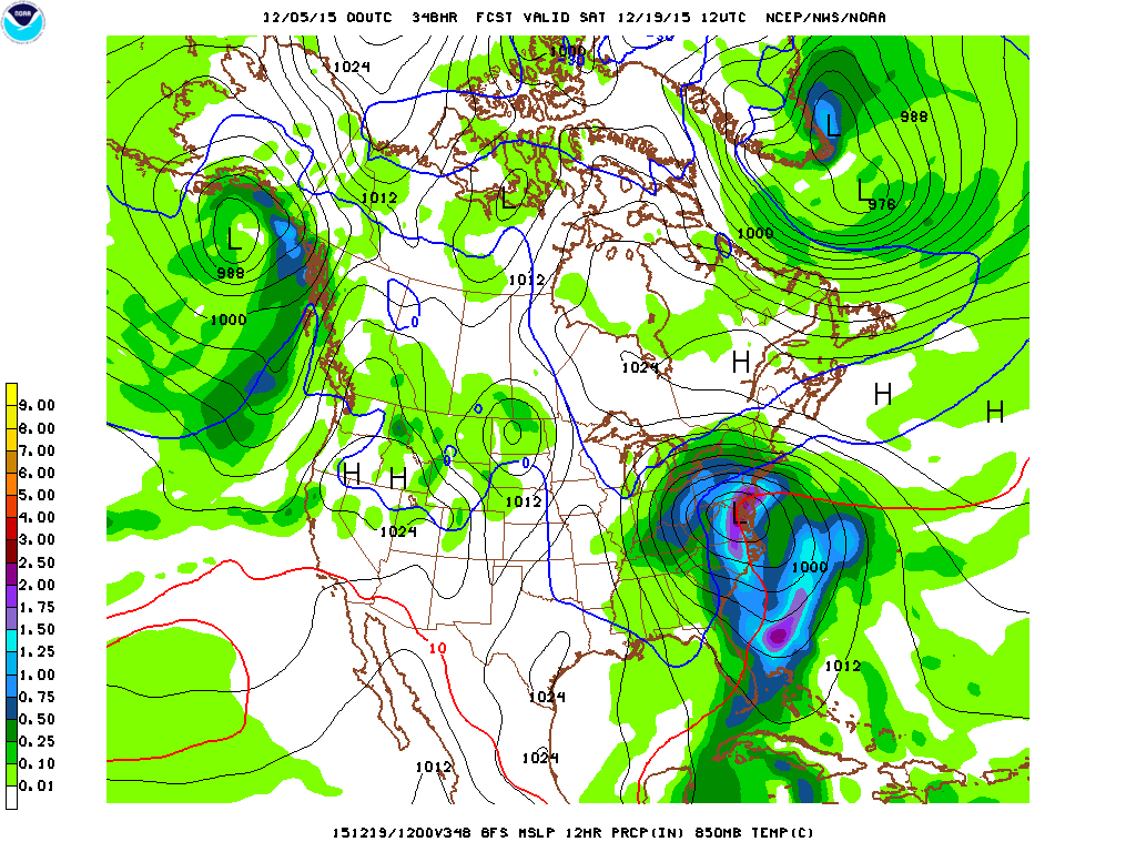
The numbers don't lie when it comes to KPITs' 10"+ storm climo, compared to east coast locations. KPIT : (4) 10"+ storms in 35 years Dulles (D.C.) (5) 10"+ storms in the past 6 years Great program though. I don't remember 2-28-84, however the PSU e-wall site shows it as a rare, rain to heavy snow event. http://mp1.met.psu.edu/~fxg1/NARR/1984.html 12-11-92 might be my favorite, just because it was the first big storm I was aware of. (Sans the 4-4-87 heartbreaker) I remember trudging home through the heavy wet snow after a pre-lunch early dismissal, but loving every minute of it. Lol.
-
Not really bitter today, just a bit dissapointed overall. We got the duration, but just couldn't get those heavy rates here. But in reality, outside of an occasional superband, like what the mid-mon valley saw last night, we're just too far away from the coast to get those double digit storms here in Pittsburgh. Nice job also with everyones input this week. Especially the Colonel, for all the map data going back before the Steeler game.
-
I'll refrain from any bitterness until tomorrow. If things play out as forecasted, it'll definetly sting.
-
I'm never going to root against snow, it's in my DNA. But at this point, I wouldn't shed too many tears, if everything shifted south tomorrow. If it's not gonna be a 10"+ storm, I would just as well have my friday night back . Lol
-
Only 30 more hrs of this to go yet. Lol It will be an interesting balance to see how the track, strength, and extent of precip shield, all work for, or against us.
-
Good point. Lol
-
I thought the model madness would start tonight, suprised by the big jumps last night. Lol Although the Euro did have this storm originally squashed south, before the jump north Monday morning. Sorta like the Steeler-Bronco game, it's a wait and see attitude. I have until late Thursday night to really have any feelings on the storm, although it's hard not to get fired up with such potential.
-
Although it was a bad pattern for snow, at least December was warm and dry. This cold and dry pattern is worse. Lol
-
Mabey this winter will have as many lives as the Steelers. One more week.
-
Finished December 2015 as the second warmest all time. Now I'm not sure how important keeping accurate daily temps were back in 1889, but we'll have to assume that due dilligence was done, and Dec 1889 is still the record warmest. On a side note I looked at the top ten warmest Decembers, and total snowfall for those seasons. And although the sample size is small, most featured >25" snowfall for the season. So it would be a kick in the you know what, if Jeff V., busted high on his forecast. Lol We'll see.
-
Lock it up. Lol
-
Chillin' outside enjoying the nice breeze tonight. Usually there's not much wind on warm humid nights.
-
Hi's 80-85 lows 60-65, I can live with that the rest of summer. Allowing temps to cool off after sunset is the key, no matter how hot the days get.
-
The past 20 years have yielded only 3 double digit storms. ( Officially at KPIT Jan 96 wasn't 10" but most of us reached double digits). But a lack of 10" storms hasn't always been the case. Doing some quick research I found that between 1956 - 1967 Pgh had 6 or 7 double digit storms. Of course we know the 60's were the Golden age for snow in Pgh. So this isn't too suprising.
-
Finally time to slowly start moving toward winter.
-
Cool and wet just north of us, warm and humid with decreasing storm coverage here in Pgh. Winter or summer, the results stay the same.
-
I like the wunderground pws network. It's nice to have real time obs closer to where you live. But the one issue is folks who don't put their pws in the correct location. Some of the obs are inaccurate, from the pws sitting in the sun. If you're gonna go through the trouble of setting the pws up, at least do it right.
-
Outside reminds me of November with more daylight. Lol The modeled cold has definetly lived up to the billing.
-
A part of me won't mind breaking out the hoodies and pullovers again. But then another part of me just wants to get on with the warm weather, and deal with it, until we get back to fall again.
-
Despite the light pollution, quite a few stars are visible tonight. Picked up orions belt in the wsw sky. Plus a brighter star in the wnw sky. Could be a planet.