

Cyclone-68
-
Posts
2,208 -
Joined
-
Last visited
Content Type
Profiles
Blogs
Forums
American Weather
Media Demo
Store
Gallery
Posts posted by Cyclone-68
-
-
Who the heck is issuing the warnings this morning? lol
-
Weird. Under a warning but no thunder or lightning in these parts
-
Deluge here but no thunder
-
1 hour ago, CoastalWx said:
Looks active in ern areas today.
I wonder if that mess on Long Island gets close to us later on?
-
Lightning developing with that cell northwest of Boston
-
Lightning picking up with that cell on eastern Long Island
-
7 minutes ago, weatherwiz said:
We always just miss out

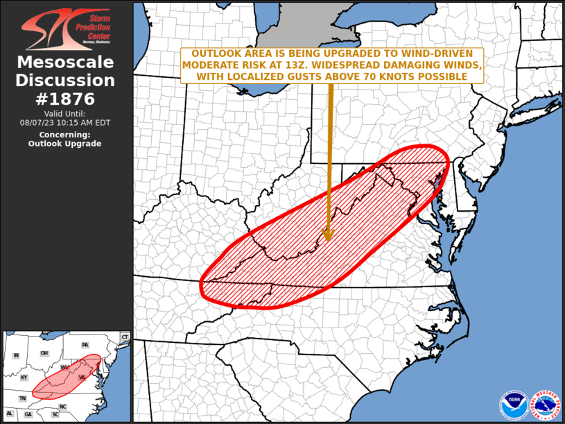
 Concerning...Outlook upgrade

   Valid 071218Z - 071415Z

   SUMMARY...An upgrade to Moderate Risk will take place at the 13Z Day
   1 Outlook update. The Moderate Risk will include areas in northeast
   Tennessee, northwest North Carolina, western Virginia,
   southern/eastern West Virginia, Maryland and southern Pennsylvania.
   Widespread damaging winds are expected, with localized gusts above
   65 knots possible.

   DISCUSSION...An upper-level trough will move through the Ohio and
   Tennessee Valleys today, with a moist airmass ahead of the system
   becoming moderately unstable. Thunderstorms will develop by late
   morning along a surface trough associated with the upper-level
   system. Supercell development will be likely around midday with a
   few tornadoes possible. A transition to a squall line is expected to
   take place during the afternoon. This squall line will move quickly
   eastward across the southern and central Appalachians. Widespread
   damaging winds are expected along the leading edge of the squall
   line, with localized gusts above 65 knots possible.

   ..Broyles/Grams.. 08/07/2023
Maybe a little something for us tomorrow? Not expecting even an enhanced risk obviously.
-
The meteorologist on channel 5 just mentioned the possibility of severe weather including a tornado threat Monday afternoon
-
That stuff in NY looks like it’s in absolutely no hurry at all
-
Bright and sunny here now. Bring on the hail
-
Weird day…Poured for about five minutes and now the sun is trying to come out
-
FWIW and probably doesn’t mean too much locally, the sun has been breaking out in the past hour or so
-
3 minutes ago, weatherwiz said:
We have not. Nothing that I can recall anyways.
Thank you kindly
-
 1
1
-
-
Question for the group. Have we had any days this summer when an EML was present but we didn’t have a front or air mass at the time to take advantage of it?
-
Let’s get some good lightning producers for Friday evening
-
1
-
-
Chance of severe on Friday?
-
Well what do my parents know anyway j/k
-
My folks live in Easton right off of Bay Rd..Completely meh according to them and my mom is terrified of t-storms
-
Cell to my north trying to back build south a bit
-
I suppose there’s a reason why we remember the big severe days so well. It’s because we get so few of them.
-
1
-
-
How is Saturday looking re: severe?
-
I really hope Saturday comes through because it might be a while or even next summer before we get an opportunity again
-
Just now, TauntonBlizzard2013 said:
Line is rapidly weakening as it approaches, evergreen.
Yup..looked good for a few minutes but wasn’t anywhere as ominous as it first looked on approach
-
1
-
-
Pretty good storm moving in here now..Thunder is house shake variety
August model and weather disco
in New England
Posted
Delayed but maybe not denied?Thunder storm looks like it broke off from the RI stuff and is headed north. Pouring again at any rate