

jayyy
-
Posts
3,726 -
Joined
-
Last visited
Content Type
Profiles
Blogs
Forums
American Weather
Media Demo
Store
Gallery
Posts posted by jayyy
-
-
Submitted spotter report for 0.8” total.
Nice steady snow falling near the Columbia mall. I’m at work down here today. I’m liking this area, Ellicott city up to Randallstown for this one. Good combo of being far enough N for good temps and far enough south to be where most models max QPF around Baltimore and its immediate WNW suburbs.-
 2
2
-
-
Light snow falling at work in Columbia. Sticking everywhere. Love to see it
-
We’re bringing this one home ladies and gents. 3-5” of fluffy white gold for most. Yeah, I said it.
-
4
-
-
Just watched a car completely sliding down a hill in dc. Amazing how bad the roads are with a half inch. I think they forgot to treat them.

This was the on ramp to 29 in Ellicott city earlier after I exited to stop for my morning coffee. Completely slick. Car in front of me almost spun out. Definitely forgot to treat it lol
That ish doesn’t fly up in the sticks. We need our roads brined cause the roads are already tricky enough being narrow / windy-
4
-
-
Light snow, 23/21. Already 0.5” on the ground
Ratios FTW!-
1
-
-
Just took the pups out and…nothing here in Monkton. Storm cancel.
kidding.
probably.
It’s comin!-
2
-
-
3 to 5

Nice! 5” contour right over mi casa. Perfect blend of being far enough NW for higher ratios and SE enough for a smidge more qpf on both the NAM & GFS.
Beautiful scene out there this morning for sure.-
2
-
-
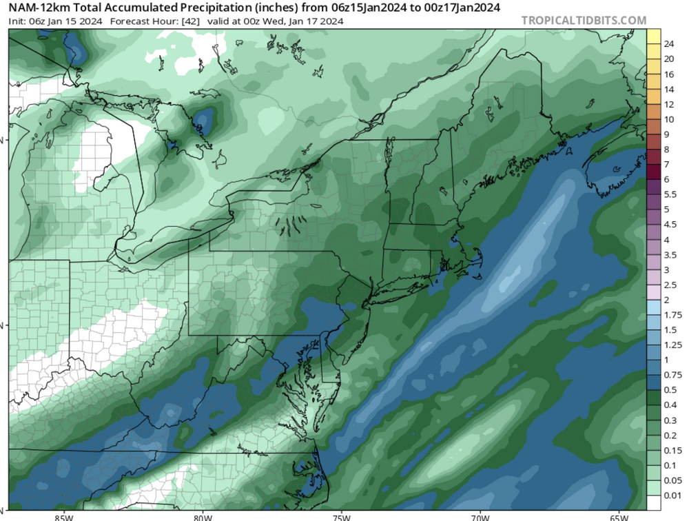
Looking at radar loops from past 4-6 hours, it’s cool to see the train of moisture spanning from east Texas to VA. The western edge of that precip in E TX hasn’t moved all that much since midnight.
12 am
4AM
-
2
-
-

Some halfway decent returns embedded in the initial slug of moisture entering the area. Currently NW of DC -
Nam with 4-7” and hrrr with some flurries love these models.
Curious to see what the more levelheaded GFS has to say. Probably 2-4” like it’s been showing for several runs now. -
WWAs are 2-3” for dc / Baltimore metros and 2-4” for colder areas like Carroll county and the northern tier
Point click forecast has 3-6” for parts of Howard county which is interesting lol
-
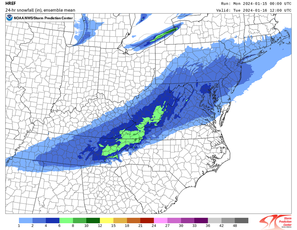
Radar looks sort of meh. I know the 'main show' isn't until the afternoon/evening. With that said, can't help but think the NAMs are overdoing things as per usual.
Tend to agree. Some precip being eaten up by the mountains I think. But if I’m not mistaken, models like the NAM are enhancing precip again during part 2 of this storm when the LP pops to the coast.
NWS has snow likely from 4pm today through 1pm Tuesday, which makes me think they’re also thinking additional precip blossoms over us. Cause I don’t see how the initial slug of moisture to our SW takes that long to move through the area otherwise. The WWA mentions a lull after round 1 before snow picks back up late afternoon through tonight. -
what do we need to do to get snow
The stars to align and unicorns to fart - per usual.
We need ridging to improve out west and more digging on our end to force that coastal to pop and develop as far south as possible. That at least gives us a shot at seeing some respectable snow before SNE gets theirs. Issue is… it’s a NS driven event, which often trend the opposite direction for obvious reasons. We know how things typically go when we’re rooting for storms to develop further south than progged at day 4.
It’s not over yet, still time before Friday.. but less confident in a snowier last min trend with this wave versus the one we’re seeing today due to the setup. It’s still possible I suppose… but this isn’t a simple overrunning event that we need to nudge N and be more amped. Would need to see some pretty drastic improvements by 0z tonight into tomorrow to believe it’s remotely doable.-
 1
1
-
-
I-66 special. Right in the pink! Down to 25.
Would love to see the GFS and HRRR show something similar to buy into the 6-7” totals for I-95 & 66 but either way, a respectable 2-4” forum wide event with 5” lollies seems like a lock at this point.
Mid Atlantic country, let’s ride! -
A cold 22 degrees with light snow
Column = moist
Should be a fun drive down to HoCo this morning. -
12km NAM looks pretty juicy FWIW
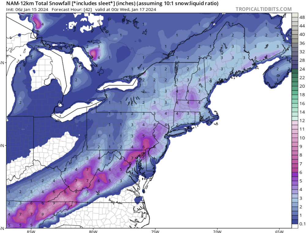
It’s showed this for consecutive runs.. but it’s also the 12k NAM. Assume the 3k is drier; but that’s also still the NAM lol. -
HREF 4-6"
HoCo bullseye
. -
Radar is looking pretty tasty right now. Nice to have an event with everyone involved for once.
The ascent under the right entrance of the jet is impressive. Radar looks tasty as a result. Let’s get it!
.-
2
-
-
THE GEESE HAVE THE FINAL SAY!
Keep that fucking goose outta here. Things trended better once it died a quick death
.-
1
-
4
-
-
I mean, it's a free service. ion know. And we've been talking about Mon/Tuesday for like 50 days. I'll be more specific next time

-
5
-
-
Probably deciding if they should pull trigger on Winter Storm Warning
Warning for 2-4” over 12 hours? Eh. Idk about that. Perhaps for some localized areas but that’s a tough call to make.-
2
-
-
That is most definitely a NAMing. 5”? Let’s gooooooooo.
NAMd with 6+. Even if I get half, I’m happy.
.-
1
-
-
Curious how the NAM GFS will look at 0z
-
I agree. I feel like it's a party for snow weirdos with mets scattered around giving out info lol.
Let's do this.
-
1
-
9
-


Jan 15-16 Storm Thread 3: Obs and Disco
in Mid Atlantic
Posted
It’s honestly hard to tell. Many of the globals seem to blossom more precip over us from the coastal, so it’s hard to gauge when it ends by just looking at the back edge on the radar. Hoping it snows through 12z tomorrow.