

jayyy
-
Posts
3,726 -
Joined
-
Last visited
Content Type
Profiles
Blogs
Forums
American Weather
Media Demo
Store
Gallery
Posts posted by jayyy
-
-

Updated deck pic. Gotta love the undisturbed snow on the chairs. Solid 5.25 event here so far. Now swing that ULL through baby.-
 11
11
-
-
what happened to all that great snow in KY/WV that was suppose to come here?
You’re literally miserable lmao. How is that other people near you have 4-6” & you’re still complaining?-
1
-
-
Snow picking back up in HoCo near 70
-
3
-
-
Coastal love about to be real out east
-
3
-
-
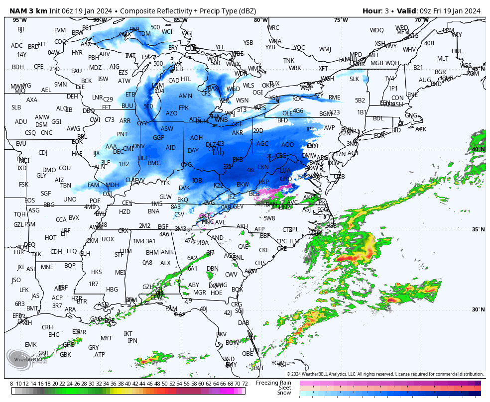
By 21z our Sfc-700 lapse rates go up to about 6.5°/km and 7.5°/km from sfc-850. Those are excellent values for this region.
21z?! We’re gonna snow till 5 pm??
. -
Just home from work. 2.5" so far despite a nearly 3 hour lull this morning after that initial heavy band. Steady light to moderate snow now. Temp is 29.
Glad to see you getting in on the action my friend. Keep us posted!-
1
-
-
Backbuilding in action
Now THAT is a legit radar, unlike Ji’s radar with backedge mode activated.
What a coup for central MD-
 2
2
-
-
I think this is near [mention=51]WxUSAF[/mention]
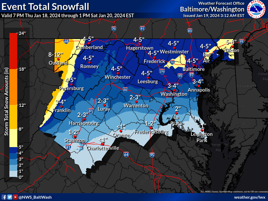
Preliminary Local Storm ReportNational Weather Service Baltimore MD/Washington DC1044 AM EST Fri Jan 19 2024..TIME... ...EVENT... ...CITY LOCATION... ...LAT.LON.....DATE... ....MAG.... ..COUNTY LOCATION..ST.. ...SOURCE.... ..REMARKS..1044 AM Snow Columbia 39.20N 76.85W01/19/2024 M4.5 inch Howard MD NWS Employee&&Event Number LWX2401709
Pretty sure that IS WxUSAF-
 1
1
-
-
The constant back building particularly over the NOVA/DC area is interesting to watch!!
Every time Ji types that the back edge is approaching, it keeps filling… epic. -
3.9” after 6 hours with first snowboard wipe. 0.2” last hour, 3 hours straight at that rate. Snow is quite light right now, but radar suggests that changes soon.
HoCo goods inbound shortly! If models were correct, the second half of this storm should be solid for HoCo and points ENE-
1
-
-

#DeckPic
4” of new snow at my brothers place in EC since 3-3:30 when it began-
5
-
-
i think it's the coastal and maybe the norlun
Interested to see how that pans out. Models pretty consistent with that impact for central MD and points NE, they just differ slightly in location and amounts.-
1
-
-
think it'll pivot but mostly for northern areas so
Curious what leads to the totals in and around Baltimore on the euro / NAMs. Is it from the Norlun feature later on? -

DC and areas just north of 66 getting the goods for sure. -
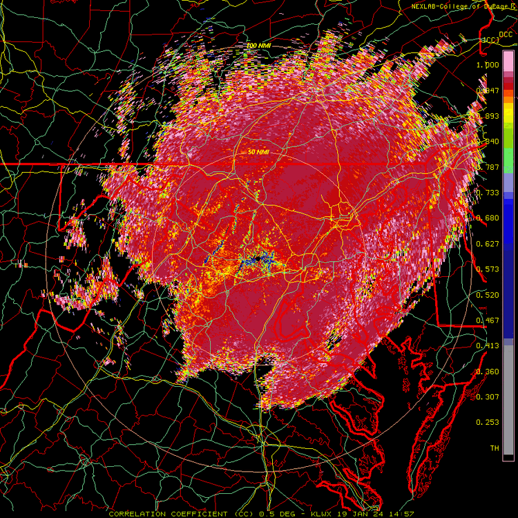
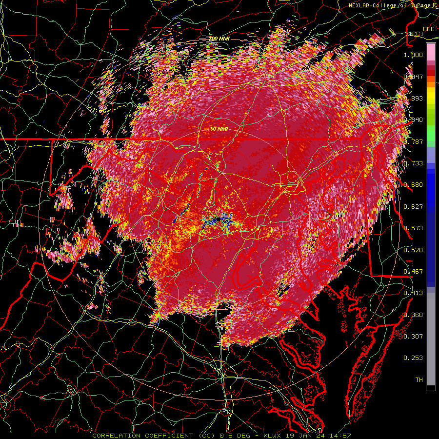
The back edge is already on radar. Lord have mercy
Stfu Ji hahaha. We get upgraded to warnings and you’re already whining-
2
-
-
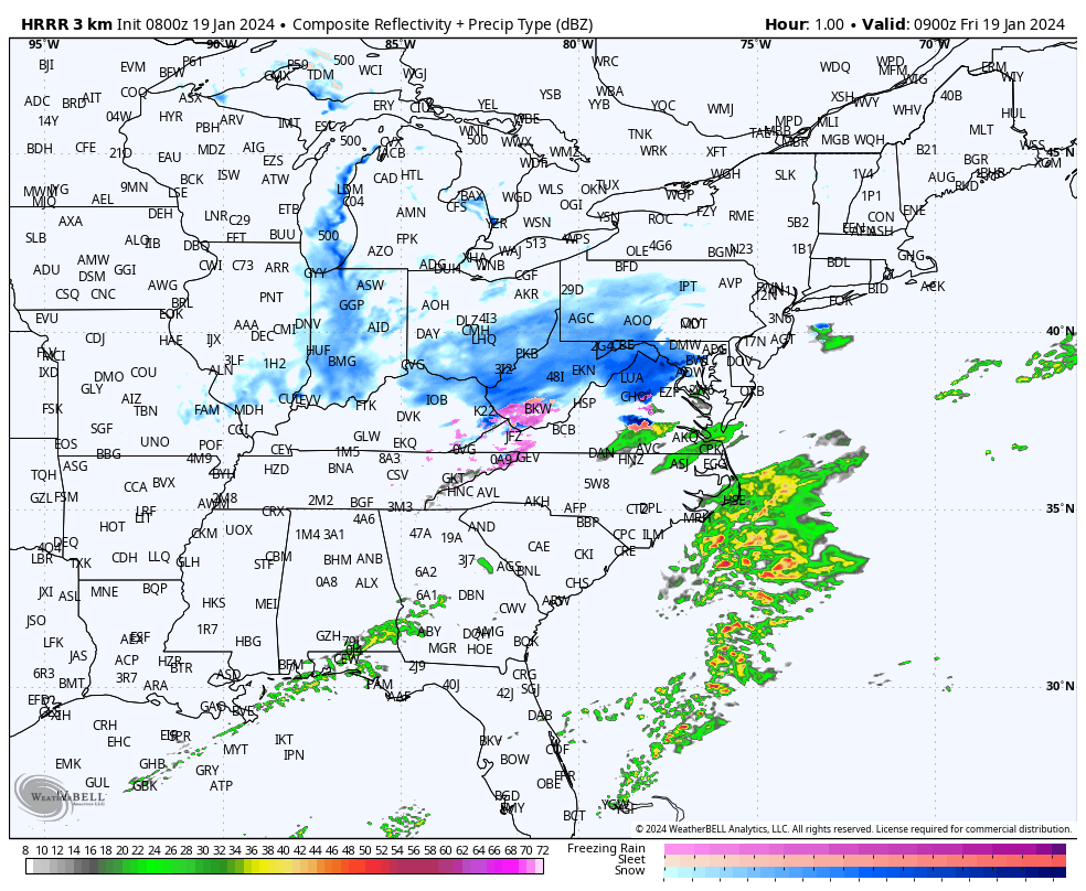
is it just me or is dry air building in faster than modeled? or is this not a concern (current radar vs the two model depictions for 4 am)

Pretty sure it’s you-
2
-
-
This snow is definitely fluffy. Ratios should be 10-12:1 for many. 15:1 in far northern spots near the M/D line
-
1
-
-
yeah and not exactly the best of conditions to drive in this AM
Certainly. Even the short commute from EC to Columbia would suck. Awaiting the text from my boss telling me not to come in today since many of my coworkers commute pretty far. -

Car and sidewalks already covered. Steady snow falling. Came in QUICK. Temp down to 28-
7
-
-

They also upped their totals!
lol ninja’d
Glad I decided to stay at my brother’s house tonight. I got off work late in Columbia and was scheduled to turn around and be there at 630am, so I decided to stay in Ellicott City to save myself 90 mins of driving to and from union bridge. May have been a good move snow wise with these last min developments.-
1
-
-
Bang! Let’s do this
What a bounce in our direction over the past 24-36 hours! Oh, niño. You have restored my faith in mid Atlantic humanity.
On that note… snow has come in quickly. Looks lovely outside.
-

HOCO MOCO Loudon also given a warning. Same 4-6” totals-
3
-
-
Warnings hoisted for 4-6”. Wow
-
1
-
-
3k too

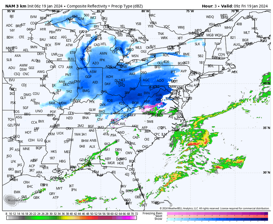
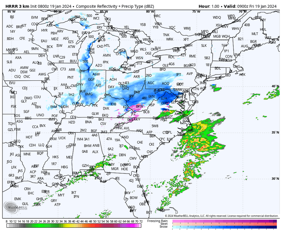
… kinda speechless. It’s the NAMs but hard to ignore 1) this close to the event and 2) when the Euro and HRRR agree (albeit not as expensive with that purple area) It’s just about game time, so let’s see what happens.-
1
-

January 2024 Banter
in Mid Atlantic
Posted
5-6 feet in some places. Damn I miss LES lol