

jayyy
-
Posts
4,065 -
Joined
-
Last visited
Content Type
Profiles
Blogs
Forums
American Weather
Media Demo
Store
Gallery
Posts posted by jayyy
-
-
Odd. The Canadian and GFS essentially swapped their h5 progressions and outcomes lol. Fucking Canadians
-
 1
1
-
-
Definite NW drift though, which is weird considering eps has been consistently SE of the OP.
Not really a huge NW drift. The heavy stuff is still way south of dc. Just a drastic expansion of the heavy snow shield on the NW side of the storm and more evenly distributed.-
1
-
-
Just look at that incredible consistency out of the ICON lol
12z finally fully phases and bombs out. What an incredible run. Watch it show 3-6” at 0z
-
1
-
-
Now we need the GFS to cave.
Lfg
It’ll get a clue by Monday -
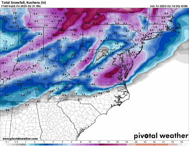
Baltimore gets 2 feet. Lord
-
WB 12Z ICON, nice start to 12Z.

That’s 10:1 too. It’ll be above that for many -
Keep losing inches in the off runs though this was not as bad as the 18z last night
I think most agree that anything under 10 now would be heartbreaking
The difference between 17 and 20 inches from 0z to 6z 5 days out isn’t really losing anything lol-
 1
1
-
-


.
A great run for all of us and it seems pretty realistic honestly. Obviously we may end up with less than 17” but I do think it’s most likely an nyc long island and SNE jackpot scenario. The euro progression is a classic for that area. Still, 17” is nothing to sneeze at from here to philly. Love the distribution! -
with the temps being at 18-22 during the storm--it has to be a low end HECS
Agree. 18-22 degrees, 20+ over a huge area from Nova to NYC and cold afterward so it sticks around. Def a low end HECS-
1
-
-
A lot of possibilities on the table. I'd feel better if we had low pressures at the latitude on both sides, closer, a slower mid-latitude flow, but a block over the top can be enough to buckle the flow under it. GEFS did trend stronger with the Canadian block today.. if it times right, we can do a monster. Still a lot of variation though in what could happen imo. You want to see more ensembles showing a hit. Watching closely. It could be a fun storm! Hopefully it holds. I'm not strongly for or against it right now.
Not for nothing… every major ensemble had this past Wednesday as a big hit for us 5+ days out and the OPs said nope. Turned out they were right. -
Why? It's close.
.thumb.png.d2c7aab985050dde1040fbdd32672686.png)
It’s cool. We’ll just pretend it’s 2008 and that the GFS is of course too flat / late on phasing. Back then you could legit bank on it being 100-200 miles too far SE. Every. Single. Time.
Go out to
Fucking
Sea
is what some folks called it
-
1
-
-

Crazy dispersement of heavy snow from VA to NYC
.-
2
-
-
Good that means he can’t find any reason to tell us it’s not happening.
He’s busy measuring the exact degree latitude of the 50-50-
 1
1
-
-
is someone able to post the snow map for the Philly area, this is the hoping region hoping for some help
Philly forum too drunk from the eagles parade to post the maps? Kidding. It’s a bomb for you guys too. Who has the zoomed out maps-
2
-
-
We are now at the 5 consecutive run mark for the euro showing an area-wide MECS+.
20+ area wide is arguably a HECS in my book-
3
-
-
High ratio powder for many. What a run. That h5 progression was legit
-
1
-
-
From h5 I think it’s another nuke
Snow maps above. 2 feet for Baltimore lol -

Sign me up. 20” contour over mi casa-
1
-
-
Thanks so much. We were all quite lost without you chiming in.
Somewhere between 0 and 20 inches. Enlightening. Idk how he does it. -
I think the GFS just needs a little more time. Let's give it till tomorrow 12z
Its SE / progressive bias is back -
This moisture sure is pretty though
Perfect example. 60-72 hours AFTER this point is plenty of time for the storm in Canada to move out and for the storm out west to get its act together. We have seen large snowstorms follow warmer rainy storms that drop the boundary south numerous times. Skepticism is warranted, especially for a 12+” outcome in a niña… but if the rationale is wave spacing, that’s not it. I do agree about the path to failure if it were to happen - a progressive solution that hits east if timing isn’t just right. We’ll see. If models are still honking come Sunday, it’s very much game on. We DO get lucky in niñas from time to time, and it seems to want to snow this year. -
I'm a bit skeptical of a big one riding on the heals of this.. This is at your -5 AO

Don't get me wrong the Pacific turns favorable.. -EPO/+PNA is definitely what we want, but I think a 4-10" event is more likely than 12-20". I can see something moving more W->E vs S->N. The pattern is actually pretty progressive, it's just a matter of really good timing, having a trough right under the Canadian block on models tonight. They sharpened the trough, but not necessarily the N. Hemisphere fundamentals. I mean it could happen like that, but there's more margin of error imo, and less high potential too without an east-pos-PNA and further SW 50/50 low
Don't get me wrong, I think there could be a snowstorm. But I'm not buying the MECS just yet.
That Saturday wave is riding “on the heels” of a storm that just dropped 8-10” of snow in southern MD on Wednesday. 4 days after Saturday is plenty of separation for another storm to brew and for the necessary pieces to move into place. Yes, it has higher fail risk than a big southern stream gulf low in a niño for instance… but it’s certainly doable. 4 major models all showed how tonight. Betting on 12-20” in a niña is never a safe bet by any means, but it’s also not impossible given the setup. Timing is everything though.-
1
-
-
Queue the uproar if these exact solutions don’t hold for 6 straight days
-
2
-
-
This is psu storm man. I'm not worthy to be the ground he walks on
Sent from my SM-A515U using Tapatalk
He did call 2/20 as the kick off… and also asked for amped solutions by tonight’s runs. Snow whisperer over there-
4
-

.png.e39234032d8f42843507ff2e1ffd0570.png)


February Medium/Long Range Thread
in Mid Atlantic
Posted
6” being the floor at 12z certainly isn’t bad. The past couple of years we all would have literally cried for a 6” storm. Now half the forum is disappointed that every single model doesn’t show 12-24” 4.5 days out lol. Weenies be weenieing