

jayyy
-
Posts
3,726 -
Joined
-
Last visited
Content Type
Profiles
Blogs
Forums
American Weather
Media Demo
Store
Gallery
Posts posted by jayyy
-
-
Oh my goodness. With the euro spitting out a 5 over Central MD...NAM says hold my beer and spits out THIS jack bubble:

Soooo… do we just ignore these because it’s so close to game time? Euro and NAM both spit out the same thing near Baltimore. NAMs jack is just more expansive. Hrrr was similar too. Interesting to say the least.
… the EE rule says game ON. -
The bottom 6-9” is a pure glacier with 4-5” of snow on top. No chance.
Busting your chops my friend. Zero shot I’d shovel that shit either.-
 2
2
-
-
06z HRRR is unbelievable
Meeeeaning? -
Took a while for the flurries but once the legit light snow started recently, it didn’t take long for the steadier snow to start.

Shovel that deck son -
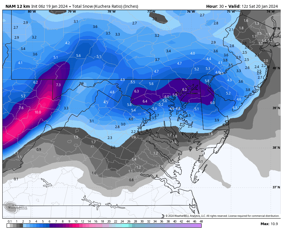
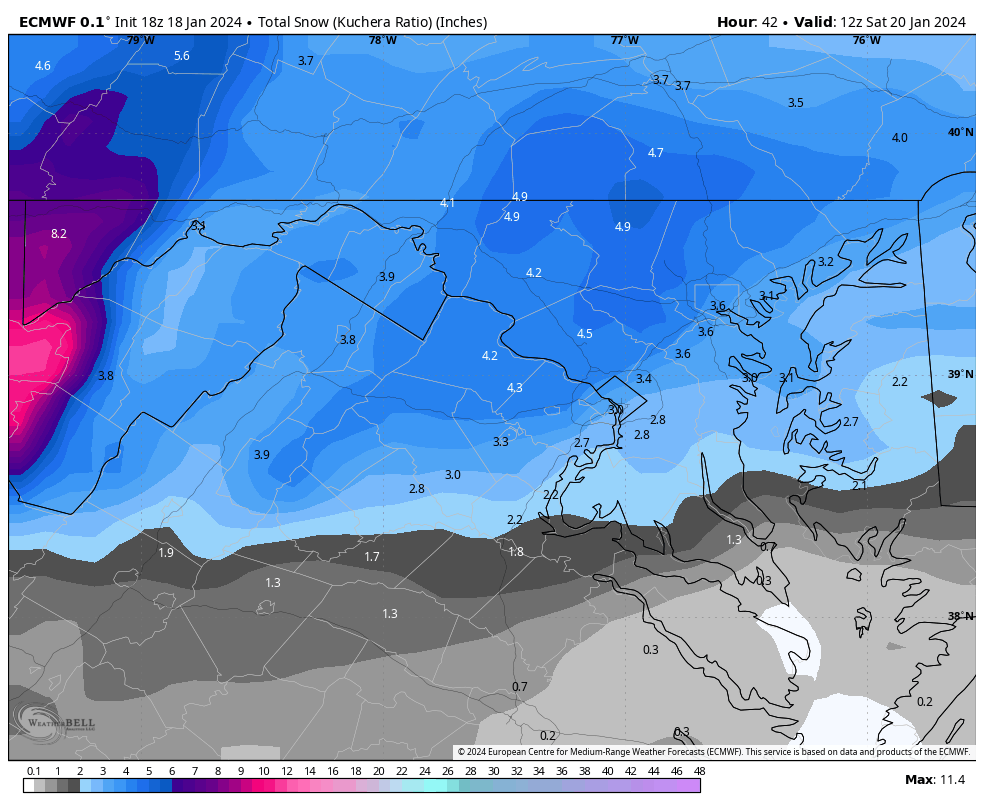
Euro pretty much nailed the Monday system once we got inside 48 hours. An inch or so low on totals across the board but did very solid with the placement of the heaviest precip. If you take a blend of the Euro, GFS NAM HRRR and RAP, there’s reason to think 3-5 with 6” lollies is also *possible* in the immediate Baltimore suburbs WNW of 95 in a boom scenario
-
 1
1
-
-
Could you show new york state?
They probably have it posted in their subforum alongside all of the “it’s never going to snow again” banter. Just a hunch. -
Well hello.

HRRR showed something pretty similar. Has a train of precip across central MD. Baltimore jackpot? It is the euro in the immediate term but def not mad about the euro as depicted.
Would be super interested to see that play out. Gotta think lift and better temps wins out though in this setup.-
 1
1
-
-
Unbelievable that that's even on the table with +NAO as strong as it is. I haven't been saying to PSU that the NAO should be positive for us to see snow, I've said that the Pacific correlating, and in many cases more than evening it out (on both sides of the index), is interesting, and could result in better winter patterns going forward in this state since the NAO has almost as strong of a precip correlation as a temperature correlation here on the EC. (I'm not predicting snow or ice with the 25th storm).
If the correlation is similar for precip and warmer temps, then isn’t warm and wet the likely outcome? 1047 high pressure in southern Canada and it’s raining lol. No thanks. -
Everyone’s asleep so they can be up at 5 am
 degenerates. My kinda people!
-
1
-
-
You need to lay off the Coke and alcohol.
Or he needs more. -
I'm gonna hop in bed with the ukie

Hoco jackpot? Interesting -
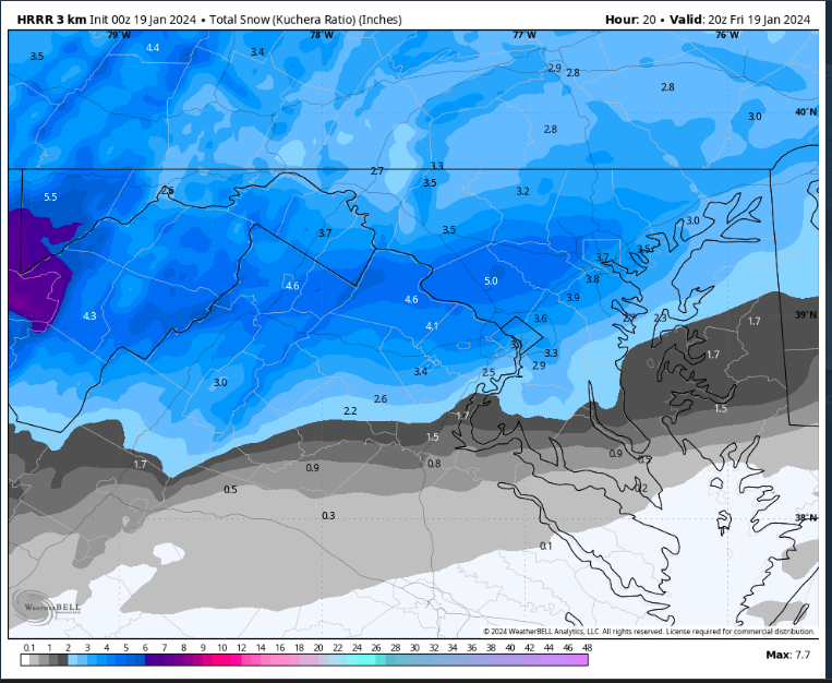
We should get 3-4".. Hrr looks pretty impressive, still snowing at 4pm. Interesting to see if they do better than the global models here in the short range.
Euro NAM and GFS all had 2-3”, with 4+” lollipops. Just differ on exact location. Not 1-2”.
I think 2-4” is a solid call for the general area with 1-2” south of dc and 3-4” closer to the MD PA border. Someone will hit 5” (prob PSU) -
GFS runnin
Come ooon baby bump south. 3-5” for all. Feeling it! Could just be the northern lights though.
. -
Oh, I' prepared this time! Fire pit is going strong. Half way through a handle. Cleared snow fro my sleeping spot. Hand warmers in pockets. But here is the game changer. I invested in a sleeping bag after my last blunder:
Details- Made for the world's most extreme mountaineering expeditions
- Rated down to -40F for the coldest, highest mountains
- 4lb 10oz weight is light for sub-zero temperature class
- 850+ fill power goose down offers elite loft and packability
- GORE Infinium adds premium windproof, water-resistant protection
- V-Block Side Baffles and horizontal baffles keep down in place
- Double Interlocking Draft Tubes, down collar ruff seal in heat
- Made is the USA with careful attention to quality and detail
Let's F'ing Go!
You didn’t see? Georgetown got its own rain advisory. -
That's a +3SD +NAO on the 18z GEFS hr 168. It connects with the lower part of the measurement in Europe and the US, too. Just impressive.. we haven't had much of that strength since 1997 (0 +analogs for the exact dates, Jan 22-28, since 1997).
Just clarifying that you know a super positive NAO isn’t a good thing, right? -
It's aight.

Not bad. In line with the general 2-4 forecast. -
Have you not been here long? It takes way more than a couple of inches to close DC schools. They are always the last to fall, if they do.
“way more”? So like… 2” more? DCPS literally closed the other day. -
RGEM is juiced up compared to 18Z
Is it really real if you don’t post the resulting clown maps? -
It was 2014. Those years get blended in my mind. So similar.
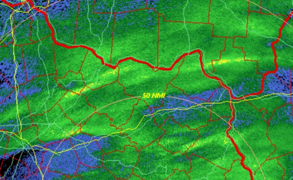
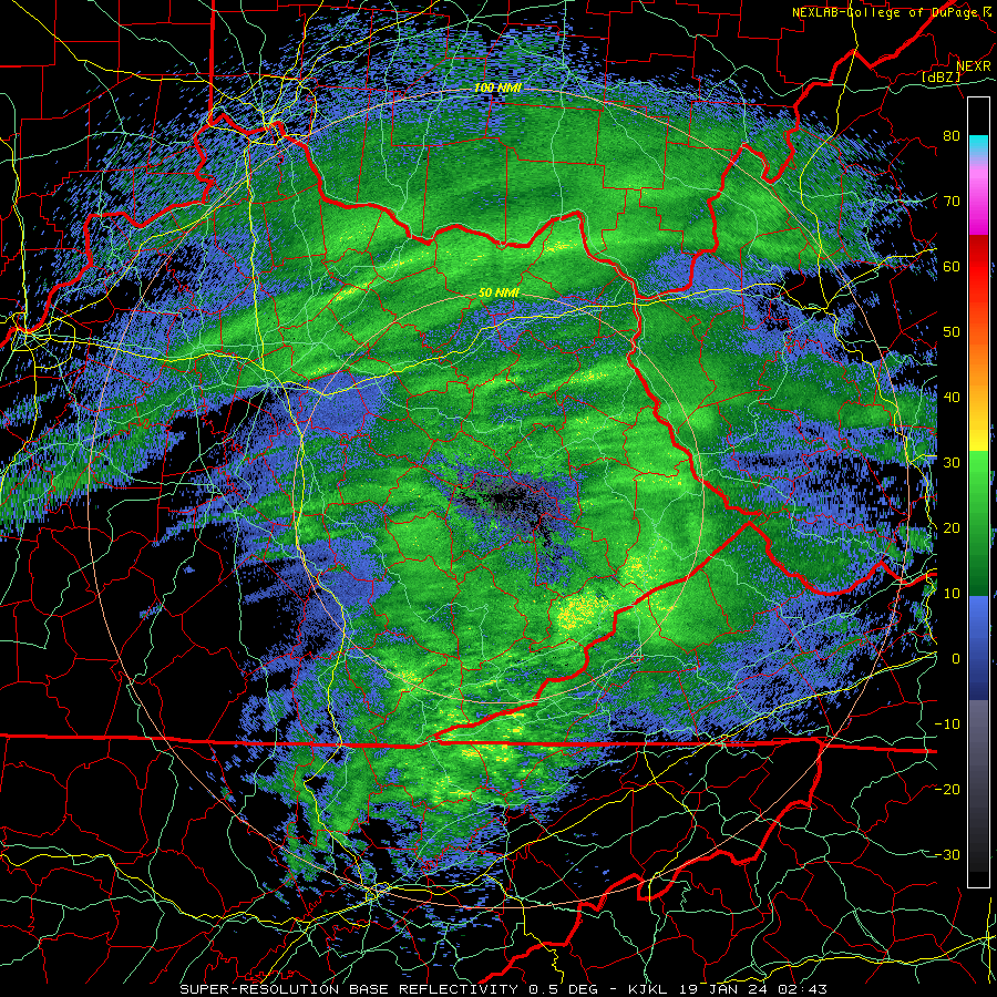
Check the yellow bands breaking out in KY/OH... I can extrapolate those to our yards.... heh
The Huntington Humbug! -
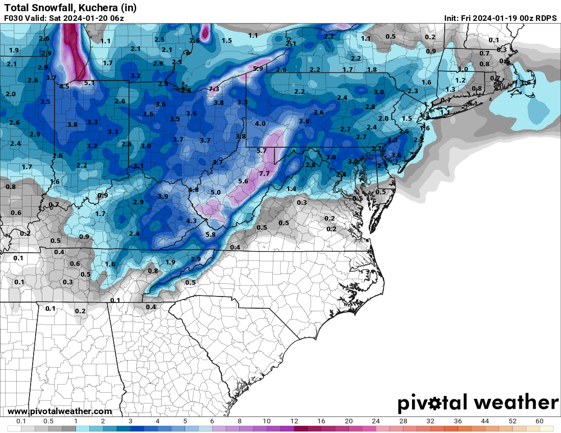
FV3 comes around to the rest of guidance. 2-4 3-5 event os coming. Look at radar:


One frame later. Precip blossoming and looks juicy in E KY-
1
-
1
-
-
I think DC region beats Philly on this one too based on latest model trends
.
Kinda wild considering one of those cities has a warning up for 5-6” and the other has an advisory for 1-3”-
1
-
-
 woah
woah
Interestingggg. Too bad it’s the HRRR-
2
-
-

Let’s fucking go.-
6
-
-
BCPS closed tomorrow
HCPS and FCPS as well

Jan 19th Storm OBS Thread
in Mid Atlantic
Posted
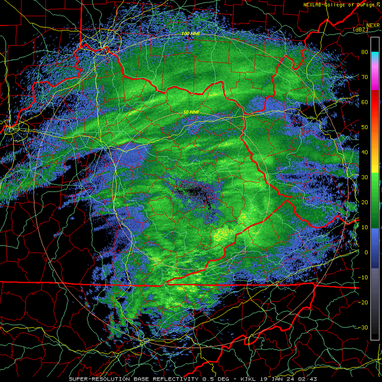
I mean… she is pretty juicy. Solid precip expansion happening in VA WV and S OH. Certainly much more organized than I expected based what models showed 36-48 hours ago. Most models had .2 of QPF