

jayyy
-
Posts
3,726 -
Joined
-
Last visited
Content Type
Profiles
Blogs
Forums
American Weather
Media Demo
Store
Gallery
Posts posted by jayyy
-
-
OT; I work with a guy that grew up just N of Buffalo. He told me once he drove to the southtowns and went from dry ground to over a foot and heavy snow in just a few miles. Did his errand and went back home to partly sunny and dry ground. That's bats!
All. The. Damn. Time. The main campus for university at buffalo is in Amherst, which is a north town. They’d get 3-6” sometimes more on the northern edge of band. Or there’d be times we’d get zero and 5 miles south near south campus in buffalo would have 18”. It goes from blizzard conditions to sunny conditions outside those bands. It’s incredible.
. -
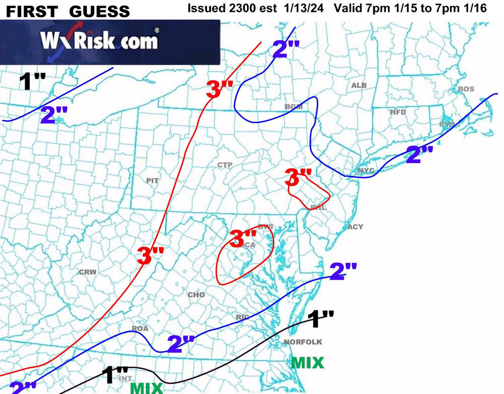
Just for fun:

URGENT - WINTER WEATHER MESSAGE
National Weather Service Buffalo NY
325 AM EST Sun Jan 14 2024
Northern Erie-Genesee-Wyoming-Southern Erie- Including the cities of Buffalo, Batavia, Warsaw, Orchard Park, and Springville 325 AM EST Sun Jan 14 2024
...WINTER STORM WARNING REMAINS IN EFFECT UNTIL 7 AM EST MONDAY...
* WHAT...Heavy lake effect snow and blowing snow. Additional snow accumulations of 10 to 20 inches in the most persistent lake snows, with storm totals 1 to 2 feet. Local amounts of 2 to 3 feet possible across the Buffalo southtowns, where bands will persist the longest. Winds gusting as high as 50 mph, with near blizzard conditions at times today.
My friend shared this this morning from Hamburg NY. Absolute blizzard out there with 3-4” per hour rates-
 3
3
-
-
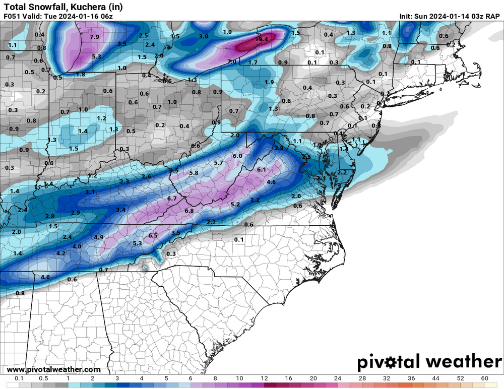
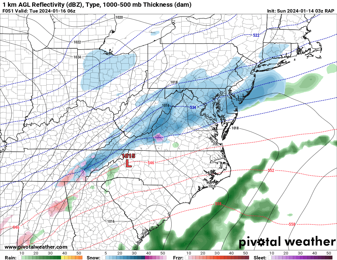
Still probably a little too early for the HRRR but damn does it look great.
Show us! (I’m at a work meeting so I can’t deep dive) -
12 minutes ago, LeesburgWx said:
For full situational awareness…
Reasonable for a change. Hate when I agree with him, makes me feel dirty.
-
 3
3
-
-
If the 6z GFS has the right idea this could end up a 2-4" deal across the region. Surface temps are dicey on the CMC SE of the fall line with precip ongoing Tuesday, and the NAMs bring the 850 0c line right up to the fall line. Could be mixy/end as rain for eastern areas in that case. GFS and Euro imply all snow with temps around 32-33 towards the end for the lowlands. NW areas probably end up with better ratios with temps staying a bit colder. PSU will probably get his 6.
Could be a mini jack somewhere in between. NW enough for better temps, SE enough for precip. Dare I say HoCo- BalCo area? Been looking that way on a lot of guidance over the past 24 hours.-
1
-
-
You serious Clark? Miller B…the B stands for ball buster. IDK if I have the chops to pursue that scenario. I’m getting old and impatient. I should move to Buffalo!
At least you know you’d always have lake effect. I graduated from the university of buffalo and it’s honestly like nothing else. 2-4” of snow per hour, sometimes higher - thunder snow at times from these bands and insane winds. That band is easily 3-4” per hour. And they have another SW wind driven LES event comes Tuesday - Wednesday which is typically a long-fetch high impact event. The best place to move around there is the southtowns. Orchard Park where the Bills play is a prime spot down to around Fredonia.
-
4
-
-
Snow squall warnings up in PA this morning. Love to see it
-
3
-
-
Most models showing a general 1-3” with some showing lollipop 4-5” amounts in localized qpf maxes. Let’s see how things look tomorrow and lock it in.
-
1
-
-
18 minutes ago, Stormchaserchuck1 said:
Yeah, that's all positive snow depth.. best looking totals if you run it out
Here's the 700mb rh at 51hr
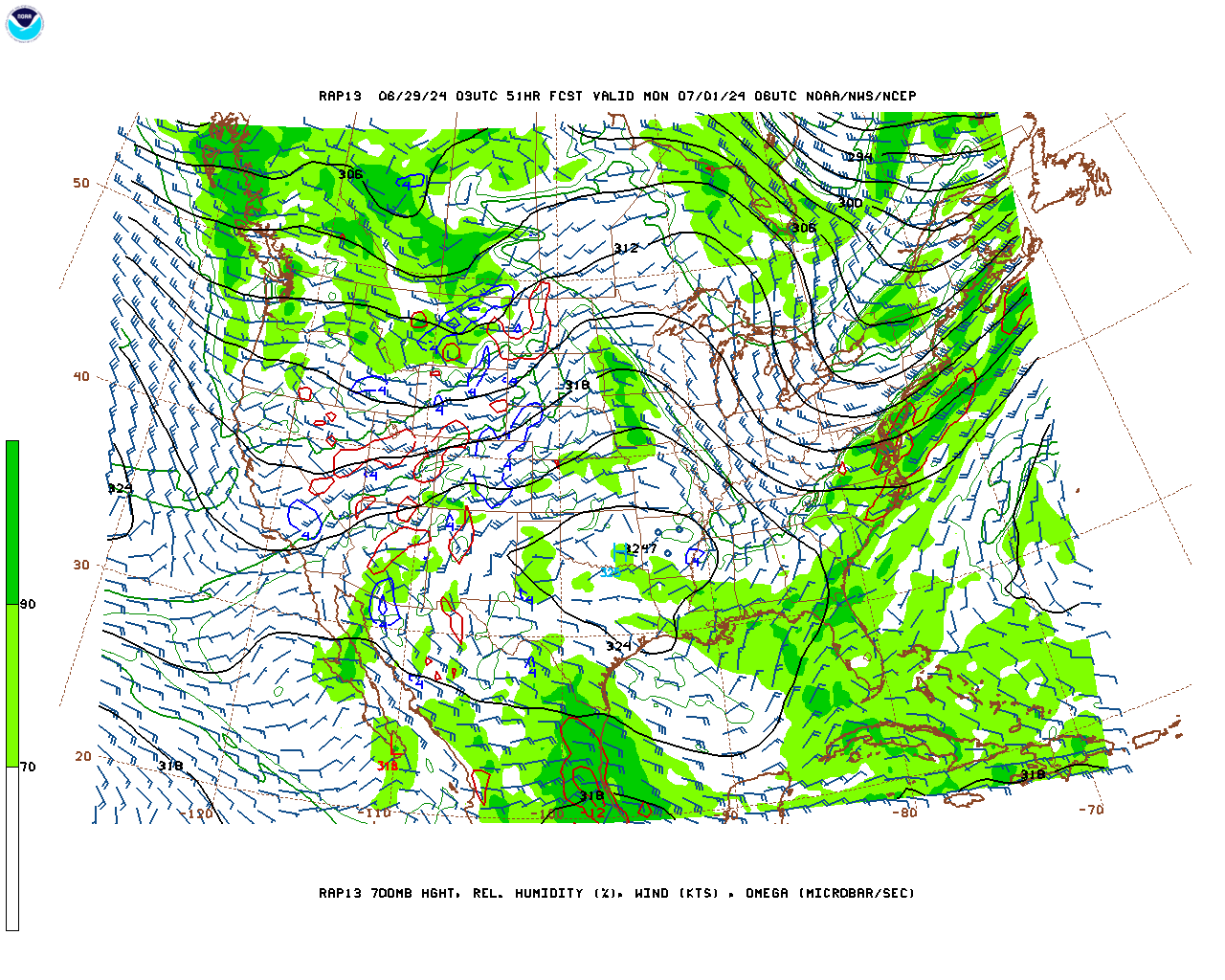 fwiw
fwiw
Welp… snow is streaming over from Tennessee, which is usually our winning path. Just not the usual way we get there.
-
5 minutes ago, DarkSharkWX said:

basically guaranteed inch on GEFS, probs around 4-5" mean w/ 0.3" qpf and adjusting w 15:1 ratiosAKA the snap the BWI/DCA streak probability map
-
5 minutes ago, StormyClearweather said:
While y'all are getting NAMed, I'm geting... uh... RAPPED. (Had to be careful there.) Snow ongoing at this point.

Can we extRAPPolate this for us or what?

-
4
-
 1
1
-
-
4 minutes ago, Deck Pic said:
well less than 90%. Why would someone give up on something like 4-5 days out?
Emotions and the ridiculous theory that it can’t snow here anymore lol
-
1
-
-
1 minute ago, LeesburgWx said:
If we keep trending up to storm time, we can get back to how it was 3 days ago

It would be pretty epic to see models 48 hour us back into a legit coastal but honestly, I’d take this current solution of a prolonged light to occasionally moderate snow event. It’s going to look and feel wintry out there and the metros should hopefully finally break their streaks. Let’s get everyone on the board at this point.
-
4
-
-
Just now, BristowWx said:
Yep. That’s 3.1 I did not have before.
3-3.5” to get me to 6-6.5” for the season heading into prime climo and a solid looking longwave pattern? Why not. Sign me up.
-
3
-
-
2 minutes ago, psuhoffman said:
As recently as 2013, 2014, and 2015 they obliterated the DC area in snowfall. What’s happen since 2016 imo is almost all our snow has come from lucky hits by progressive boundary waves during short periods when we got an epo pna ridge. Those don’t favor Winchester. They downslope in those plus they are kinda random and usually if you’re on the cold side of the boundary it’s cold enough. Being NW and higher offers no real advantage in those. So recently the difference is less.
I think if we go back to a +pdo with more coastal storms and inside runners they will go back to doing better again.
Ninja’d by PSU. Was just gonna say… when the overall pattern gets back to classic miller a noreasters and coastal bombs / huggers, Winchester will once again destroy IAD in snowfall. Been a very weird last 7 years.
-
1 minute ago, psuhoffman said:
What’s the bar for folks on this?
2-3” would def be a win
-
4
-
-
14 minutes ago, high risk said:
The main focus is on us getting NAM'ed, but I'll just make a quick point that this isn't really true. The SREF is a mix of 13 ARW and 13 NMMB runs using a mix of RAP, NAM, and GFS initial conditions (and multiple physics). Yes, half of the members have the same model core as the NAM, and roughly 1/3 use NAM initial conditions, but it's not a NAM ensemble.
Ahh gotcha. Knew there was crossover. Thought I read somewhere NAM ensemble was the Sref but I must have misread it.
-
Just now, Terpeast said:
18z and 00z nam seemed to be in good agreement up until hour 60 with the first wave, then diverges apart with the second one. Either way, I’ll take what the first wave dropped verbatim. Anything after is a bonus
Id take 3-4” of fluff and solid cold to follow all day long. It’ll be a very wintry 24 hours out there.
-
1
-
-
5 minutes ago, Ravens94 said:
Trying to form a surface low should definitely be a better run
A better run? Really? Didn’t it drop 7” on Baltimore at 18z
-
2 minutes ago, NorthArlington101 said:
Idk about those plumes but on WxBell the 21z SREF juiced up so maybe we’ll get NAM’d again at least

For sure. Gotta think there’s another NAMing inbound since it’s the Nams ensemble.
Most models are actually in pretty solid agreement about the local max area that expands from eastern hoco’ish to points NE hugging the bay. BWI may end up actually being a pretty decent spot for this one. -
2 minutes ago, clskinsfan said:
Dont be too excited. Winchester model jacks with every god damn storm and fails miserably.
Hard to jackpot when it doesn’t snow anywhere lmao
-
1
-
1
-
-
1 minute ago, aldie 22 said:
Lol poor Ji
Weather gods punish permadebs
-
1
-
 1
1
-
6
-
-
Nope, we will get a WWA coupled with a beet juice warning
Pretty sure a CWA wide WWA would look like porn at this point.-
6
-
2
-
-
24 minutes ago, osfan24 said:
Ha, this looks like it might be the main course.
Too early for that talk


January Discobs 2024
in Mid Atlantic
Posted
Confirmed: it can still snow in the lowlands.
37 and snowing leaving a work meeting in Columbia
.