

jayyy
-
Posts
4,065 -
Joined
-
Last visited
Content Type
Profiles
Blogs
Forums
American Weather
Media Demo
Store
Gallery
Posts posted by jayyy
-
-


ICON came in more in line with the NAM RAP HRRR GFS for sure. Not a huge bump north, but certainly noticeable for central MD-
 1
1
-
-
NAM overamp bias? We shall see. Man oh man, the battle of the models continues. We’re talking about 75 mile shifts in any given direction but those shifts means the world of difference for the N and S fringes of the forum. Central MD seems to be sitting pretty for this one right now.
-
2
-
-
Forecasts are always a range.
Thanks, I know. Usually their maps are a bit tighter than 4-8” though. But again, it makes sense given where things stand currently. -
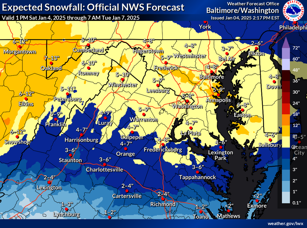
Reasonable to give a range given some of the uncertainties we face. Seems like they considered our local climo and a blend of models for that call. -
Surprised anyone here actually still tunes in to their forecasts tbh.
-
2
-
 1
1
-
 1
1
-
 1
1
-
 1
1
-
 1
1
-
-
Call map from DT. Good luck everyone.
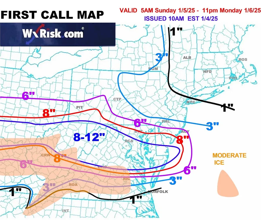
Dare I say it…. Actually pretty reasonable
.-
3
-
-
WB 15Z NBM.

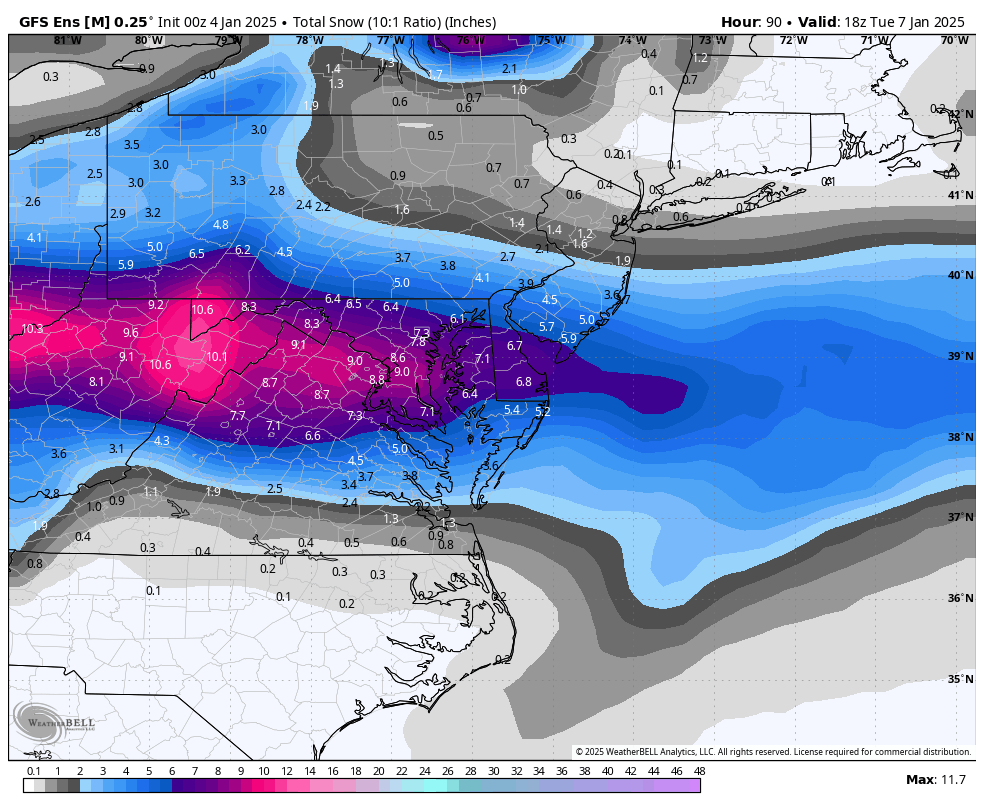
NBM blend has been rocksteady with what I’ve had in mind for this storm for days. It’s not always spot on, but it gives us an idea of what’s possible given the uncertainties we’re facing. This would be a win for pretty much everyone. I live in Carroll county so this isn’t an IMBY thing; I can’t shake the idea that the MOCO - HOCO deathband zone will likely do well with this one. Not buying the 3-4” depictions from some models. This setup has a classic look at 500mb for that area to do well on the NW side of the storm.
Can someone remind me what models get considered in the NBM blend? -

CAD all the way down into NW NC. Classic signature right there-
2
-
-
FV3 is my soulmate. Still a ways to go snowfall wise after this too.

I know it’s the FV3 RAP and SREF, but they’ve been pretty consistent on the due W to E nature of precip. Cautious on those though as we’re definitely outside of their useful range-
1
-
-
I’m watching the gradient and seeing where the fronto will align with it. I don’t know that we’ll get a north trend but the northwest edge can definitely perform even without it. We’re gonna go from 1 to 6” somewhere in 40 miles or so.
Agreed. The area i’m most interested in as far as “boom potential” is the moco-hoco-bwi corridor. If models are underdoing the dual banding aspect, they could score some nice totals in that area where they stay all snow but are also far enough south. Going to be a nailbiter for sure. -
00z tonight should be interesting. We’ll finally be within *roughly*24 hours of the onset, so hi res models will hold a lot more weight.
-
5
-
-
GFS / NAM locked in. Lets see the euro come in line by 00z tonight and were all systems go
-
00Z GFS ensembles look good, a bit south.

Looks great -
Don’t post all at once now

-
2
-
-
GFS essentially held serve. Nice to see it not go south. On to the next.
-
2
-
 1
1
-
1
-
-
What trend? We don’t even have the full 0z suite yet. If the euro goes significantly south I’ll worry. And there are still 5-6 model Cycles left before we get to the range the exact location of banding will be figured out. The last snow we got Feb last winter went from a MD bullseye 48 hours out to giving Allentown PA 12” and MD 1-3”.
It won’t matter if it were way down south and we needed a 150 mile shift. But a 50-75 mile shift the last 24-36 hours is absolutely nothing and happens almost every storm one way or another. We do this every time. People act all “how can the models be this all over the place when it’s only 48 or 72 hours” when this is totally normal. We haven’t progressed as far as some think. 48-72 hours is still a long time.
People have apparently forgotten both “thread storms” just last January where things looked bleak and south 48+ hours out, only to come back north… along with countless other storms that have not held serve 2+ days out over the years.
It happens frequently. Does it mean it’ll happen this time? Of course not. Maybe Richmond does jackpot. But we’re talking about models waffling 50-75 miles per run based on small variations in confluence, vort strength, etc. This is largely noise. If someone asked me to bet on whether a storm (especially one with a re-developing coastal) is more likely to shift north / stronger or south / weaker inside 60 hours, I’d bet on a north bump 9 out of 10 times… unless there was some crazy strong high to our north (which there isn’t) Temps will be in upper 20s to low 30s so we’re not talking about the storm being overwhelmed by confluence to our north. History teaches us a lot. This may be one of those times where models continue south, but a compromise between the nam / gfs and euro seems most likely to me.
Let’s see what 00z gfs and euro have to say, but this synoptic setup with a ULL pass to our south usually means solid snow for most of the forum -
I expect it to trend north some the final 24-36 hours. So long as this is where it is now were probably fine. It’s when DC is on the northern fringe 48 hours out that we’re in big trouble.
My thoughts exactly. I think Baltimore and points west are still very much in the game for big totals. Even the northern tier is still in it for warning level snow given temps and ratios. Tomorrow will be very telling. If euro continues to tick north and gfs / NAM hold serve, it’s game on-
1
-
-
I’m off work on Monday. May stay down at my brothers in HoCo rather than up here in Carroll County for an easier commute to work on Tuesday (and in hopes of seeing a bit more snow honestly)
-
Baltimore jack on NAM wowza
-
2
-
-
Just in case anyone was wondering, the purpose for the NBM. As we know, most model suites have their ensembles at lower resolution. NBM was conceived to take operational models for the most part and use them as an ensemble suite. It makes sense since the operationals have the highest resolution. This was told to me on Phillywx by Rainshadow, who retired from NWS Philly a few years ago.
I know many tend to hug the snowiest for their backyard, but a blend of all of the major OPs makes total sense for actual forecasting purposes. If GFS / NAM also go south tonight and euro holds serve, that’s when I’ll be a smidge worried for Baltimore & north. And by “worried” I mean 4-6” instead of 8-12” -


Come to papa haha. Euro doing its typical waffle 48 hours out before trending back to its 3-4 day depiction? We shall see-
 2
2
-
-
How reliable is the SREF ARW? WB 21Z


I know it’s the SREF blend but this is what I have had in mind for days now. Makes the most sense to me based on setup and climo. We shall see though. -
Euro is pretty clearly a bit too far south given the synoptic setup, imo.
That said, I don't think the GFS evolution is the final answer either. More fun to come. Most likely some sort of a compromise, which should make most folks here happy.
Agreed. Been beating this notion like a dead horse as of late but a split of the euro / gfs seems most likely, which is 6+ for most of us.-
1
-
-
Still putting my jackpot in the general latitude of Leesburg to germantown to Columbia to Easton for now. Will see how things look by tomorrow 0z but I don’t buy the dc south jack quite yet. Euro has been known to lose things 48 out to get them back closer to game time. Can’t shake the general climo aspect to this storm, especially early on in a cold pattern.


January 5-6 Thing II: STORM MODE
in Mid Atlantic
Posted
Yep. Makes a lot of sense. Someone’s going to get caught between the dual band structure for a time. Rising and sinking air and such. Hope it’s not Baltimore but it very well could be.