

jpeters3
-
Posts
736 -
Joined
-
Last visited
Content Type
Profiles
Blogs
Forums
American Weather
Media Demo
Store
Gallery
Posts posted by jpeters3
-
-
Just now, Brian5671 said:
here's a pic of gilbert, you're right-very compact. Went right into Cozumel as a 5
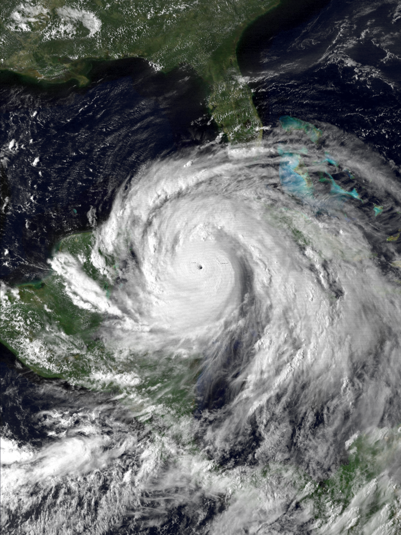
The outer circulation of gilbert was clearly much larger. Also, gilbert was undergoing an ERC when it made landfall, so probably had a much larger RMW at that point.
-
9 minutes ago, the ghost of leroy said:
Dude doesn’t even know when 12z is but thinks he knows more than Jim Edds
Regardless of how much you think Jim Edds knows, a sub-900 hPa "call" is simply not based on science. Yes it is possible, but probably unlikely given (1) the relative infrequence of such events, and (2) the moderate shear currently affecting the system (going sub-900 requires pristine conditions).
-
 1
1
-
-
1 hour ago, Windspeed said:7 hours ago, NJwx85 said:Honestly, who gives a damn what the seasonal ACE ends up being if most of the activity stays out to sea. I think the majority would agree that a category 2 hurricane making landfall in the US is a lot more interesting from a hobbyist standpoint than a category 4 hurricane re curving way out to sea.
I mean part of an active season, especially hyperactive is your general September central Atlantic hurricanes. They usually produce a big chunk of ACE and most of the hyperactive years have them. I just enjoy tracking, attempting forecasts and observing the outcomes. Whether they are land threats or not matters little to me. Though I would prefer they avoid populated areas. A big CV hurricane is my favorite even if it threatens nothing but shipping. Aside from Dorian, Lorenzo was an incredible storm to track as well last year. Perhaps we'll get a few beasts over the next month.
Yeah I'm with you. I would rather see a monster cat 4 or 5 storm that remains out to see, than mayhem/destruction related to landfall. This is why I find the east pac season fun to track.
-
FWIW, forecasted shear among dynamical models is generally in the 20-30 kt range upon entry into the gulf.

-
 2
2
-
-
1 hour ago, the ghost of leroy said:
Whatever happened to being patient? Laura is in its infancy and the calendar date is 8-21. YOU PEOPLE really don’t deserve a long tracker. You haven’t proven you can responsibly talk about it.
This ^^^^^
-
1
-
-
VWP from KINX is less than impressive in the lowest km. Actually, there is more ESRH for left-movers, which probably explains why the left split moving toward Columbus KS is holding its own.

-
1
-
-
6 minutes ago, MUWX said:
The WF continues to push NE, correct?
right, but the wind field will change completely as that happens. So that profile has no bearing on the severe threat further south the warm sector.
I could probably find a thousand hodos a season north of WFs with 1000+ J/kg of 0-1 km SRH.-
1
-
-
2 hours ago, DanLarsen34 said:
Not sure why he tweeted this hodo. It's 61/56 at SGF, so clearly on the stable side of the WF.
-
On the same token, I also believe that 5-20-19 should have been a high risk, despite having under-performed. 9 times out of teen, that type of setup will produce a widespread tornado outbreak.
-
I strongly agree with SPC's decision. Hindsight is 20/20 - there were considerable question marks approaching this event (more than in the case of 5/20). 9/10 events with this many uncertainties approaching the event do not end up becoming major outbreaks. So I think it was a good forecasting call. A high risk would have been irresponsible, IMO.
-
1 minute ago, Bob's Burgers said:
So to sum this mess up over the last 30 minutes, I think we had a weak, unwarned tornado dissipate, then, a non-traditional occlusion of the original mesocyclone that somehow lead to additional tightening and a tornado with a straight northerly motion that went straight out of the polygon. Then, the second meso intensifies west of Chambers, drops a massive tornado, along with at least 1 anticyclonic satellite. lol
bingo.
-
New circulation forming.
-
1 minute ago, pbrussell said:
I love Internet forums. Sorry guys
¯\_(ツ)_/¯
Just thinking about the last time I watched a supercell cycle and produce violent tornadoes as long as this one has. Chapman is what came to mind
You are an evil satin worshiper for what you said.
;-)
In all seriousness, sorry for being a dick. -
TDS and no warning.
Edit: just issued. -
Just now, Wmsptwx said:
Shouldn’t we wait and see on damage and things...I agree on April 12th but this is at least as impressive if not more that last weekend.
The Bassfield storm produced larger TDS signatures, stronger GTG velocity, and lofted debris higher. More impressive thank this.
Oh, I see what you're saying. It's quite possible that this storm produced a violent tornado, but nothing has screamed "more impressive" than the southern MS storm from last weekend, much less countless other storms over the past few years.-
1
-
-
I think this is about to produce a massive tornado...
-
Just now, pbrussell said:
Pretty big tds there. This supercell is the most impressive storm I’ve watched since chapman ks. Perhaps more impressive?
There were several more impressive ones a week and a half ago in MS, and another one last weekend in MS.
-
Just now, Bob's Burgers said:
Looks like a possible inflow surge over winworth.wouldn't count them out yet
I think a new bigger meso is forming over winworth...
-
Looks like there might be multiple areas of, at least weak, rotation
-
Just now, Moderately Unstable said:
It's a cycling supercell in a good environment. I'm racking my brain thinking about what's causing the cycling instead of a sustained long tracker. The winds are backed, low level SRH is quite high, no other storms to interact with. Odd. Whatever the damage track(s) is/are tomorrow, it will be interesting. There are no spotter reports on this since the Seven Oaks area, yet there have been multiple debris balls, and other signatures, in a good environment. We have learned so much about tornadogenesis and forecasting the last decade, to the point we can use debris heights, to estimate tornadic wind speeds. But I still don't know of any literature that would explain why this supercell is cycling so much and others just "stay down". Not complaining, this would be a heck of a damage path if it was all on the ground. Wonder if the storm base here is higher and it's therefore having more trouble sustaining tornadoes on the ground, even though, say, 1k feet up, we've got a fairly continuous funnel. But earlier videos didn't show a high cloud base so that kinda puts cold water, somewhat literally, on that theory.
Edit: spotter report did just come in suggesting a tornado in Jasper, from a 911 call center. 5 E of Jasper. So, that may have been the start of that particular touchdown. There is another uncorroborated report of the tornado OG in Jasper, of unknown magnitude, also 911 call center. That may have been strong RFD that gave off the appearance of a tornado. Won't know until much, much later. Can you imagine what this would have been like were it actually on the ground for the whole distance?
I think it has been on the ground virtually the whole time. There haven't been any moments where the meso turned left and shed into the RFD. Obviously this isn't always how cycling happens, but the debris signature has been so consistent.
-
1 minute ago, TexMexWx said:
The motion shown in the videos was certainly indicative of a powerful tornado; do you have specific examples of damage photos/videos that are evident of that sort of rating? I haven't found too much on that yet
I think they are basing it off of SPC's radar-based judgement.
-
1 minute ago, 1900hurricane said:
That'll do it...
-
Just now, MUWX said:
Jeff P is on a torando right now
Link?
-
Low-level lapse rates are very small in this area (you can see the warm nose in the TAMU sounding). This might be an inhibiting factor.
Major Hurricane Delta
in Tropical Headquarters
Posted
Sub 900 is exceedingly unlikely, so it still doesn't make him an idiot for calling this one out. And what does not knowing when 12z is have to do with anything? I have a PhD in atmospheric science and I can't remember how 12z translates to local time on most days. Does that invalidate my meteorological knowledge?