

jpeters3
-
Posts
736 -
Joined
-
Last visited
Content Type
Profiles
Blogs
Forums
American Weather
Media Demo
Store
Gallery
Posts posted by jpeters3
-
-
10 minutes ago, MUWX said:
I mean, that may be true, but its a NWS Met in the target area basically saying to discount it.
It's just the type of statement that requires a fairly detailed scientific study involving analysis of many events and inter-comparisons between regions to validate (which doesn't exist). From my experience, even seasoned forecasters can succumb to "forecaster dogma," and this sounds like exactly that.
Not saying the 3km NAM is a great model, but it seems like folks are looking for wishful reasons to excuse it's latest solution.
-
5 minutes ago, MUWX said:
One of the Birmingham NWS mets was on twitter saying that the NAM 3KM rarely produced realistic convection in the SE.
This is not a statement with too much scientific support, so I wouldn't lend too much credence to it.
-
Lots of quibbling here over details this far out. At this point, I think we can all agree that we have the potential for a VERY high end event. But like many recent would-be high events that did not pan out, the current guidance suite has also shown us a few ways that this could bust. Maybe it will bust, maybe it won't? Obviously too early to responsibly make a call either way.
-
 3
3
-
-
43 minutes ago, Quincy said:
There are failure modes for sure. If there’s too much convection too early, that would also throw things off.
To get a major outbreak, the needle really has to be threaded just right. Low-level instability is one limiting factor.
I’m mostly concerned because global and mesoscale models alike show CI in the unstable/highly sheared warm sector, which is what you’d expect to see during an outbreak.
How high will the ceiling be? We’ll see. I’ve been burned for being too bullish on occasion.
All it takes is one...
Let’s hope that for the sake of the local residents, this does perform below expectation.
I do agree that the ceiling for this event is a high end tornado outbreak.
-
5 minutes ago, Quincy said:
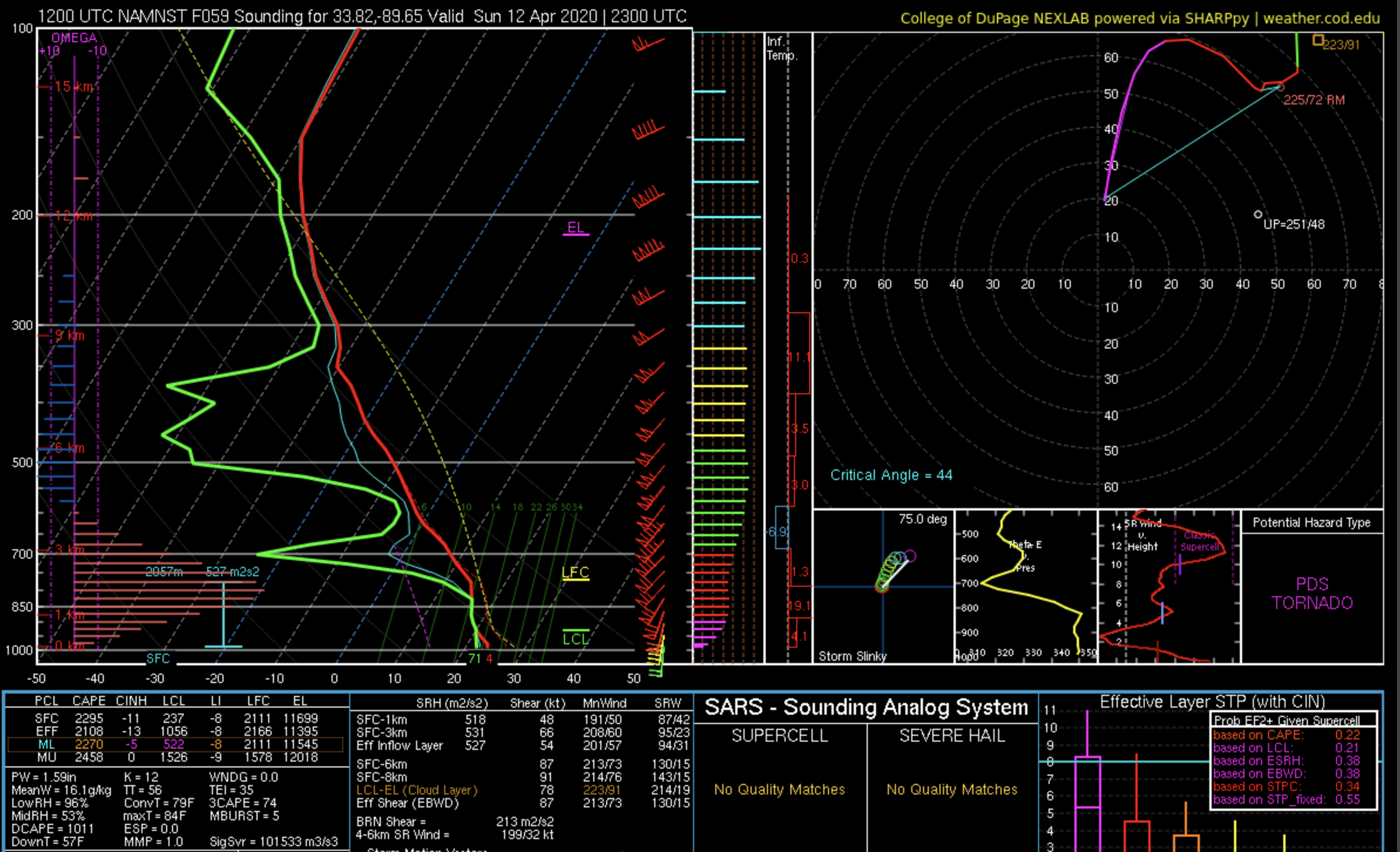
6.8 C/km is the average 0-3km lapse rate for significant tornadoes:
https://www.spc.noaa.gov/publications/mosier/2018-JOM1.pdf
Taken verbatim, the NAM shows 6-6.5 C/km lapse rates with around 100 J/kg 3CAPE through much of the risk area.
Given the wind profiles, that’s definitely supportive of strong, long-track tornadoes.
Maybe if the low-level lapse rates were steeper we’d be talking about a historic event. I would not go there yet, but I think to argue against a tornado outbreak at this stage is a stretch.
I should have been mores specific. What I was referring to is the buoyancy at low-levels for a lifted parcel, which is on the low side because of the mentioned warm layer blow 300 mb. This is something that has been shown in research to inhibit tornadogenesis. You'll notice that there is almost 0 CAPE below ~ 2.5 km in these soundings.
Also, the average 0-3 km lapse rate for violent tornadoes (per the preprint you posted) is 7.2 C/km, with a lower bound at 6.5 C/km. So this lapse rate would fall within the lower range of violent tornadoes.
Also, nobody is saying there isn't going to be a tornado outbreak (myself included). All I said is that the NAM and NAM Nest are not showing solutions that are consistent with an outbreak. This does not mean one won't happen, but it's not something that should be ignored in lieu of wishcasting ether.-
 1
1
-
-
10 minutes ago, Quincy said:
Uh, that’s a sounding from hour 59 in NW Mississippi. I see plenty of warm sector CI by 19-20z. (Including cells directly over the 33.82, -88.65 data point at 23z if you look closely.
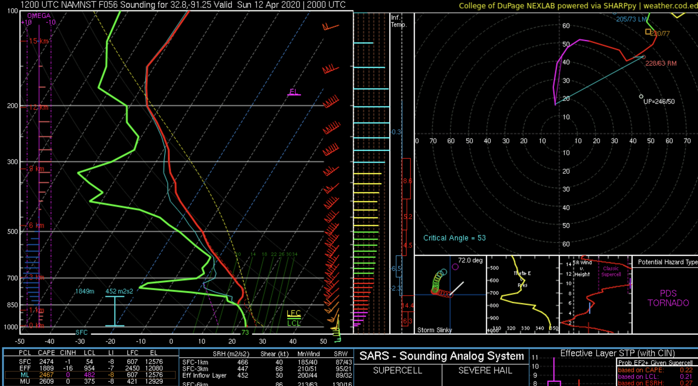
I would normally advise against detailed sounding analysis of the 59hr 3km NAM, but FWIW:

The sounding was simply posted as an example of a signature that shows up broadly in both the NAM and NAM nest. My post contained the proper "words of caution" that should be attached to any analysis of any model solution for any severe weather even 3 days out. And the fact is that this solution does not show a tornado outbreak. I see a lot of warm air advection driven junk to the east part of the warm sector, and then a squall line along the cold front. The main region of the warm sector with the highest parameter values>
Also, the sounding was taken sufficiently far head of the squall line to avoid convective contamination. If you were indeed correct and the sounding were contaminated, there would be a deep region of saturation and ascent through the troposphere (like in the second sounding I posted). There is in fact no such signature. It's possible that there is some model representation of low-leevel convection (again related to the warm air advection) showing up.
In any case, whether or not the sounding i posted is "contaminated" does not even negate my original point. This model solution is showing a potential bust mode in terms of a widespread severe weather outbreak. This is not something that can really be argued with.
Multiple soundings from both the NAM and NAM nest have been posted here, or are available for you to look at yourself, that show relatively poor 0-3 km lapse rates. This has been a bust mechanism for events in the past, and could be one here.Also, the "cells" you point out in the warm sector in the vicinity of this sounding most likely represent shallow (not deep) convection.
-
1 minute ago, Upper Level LOL said:
Other than that though.....
I'm sorry but you are simply incorrect. I didn't spend 10 years in in college studying this subject for nothing...
-
2
-
-
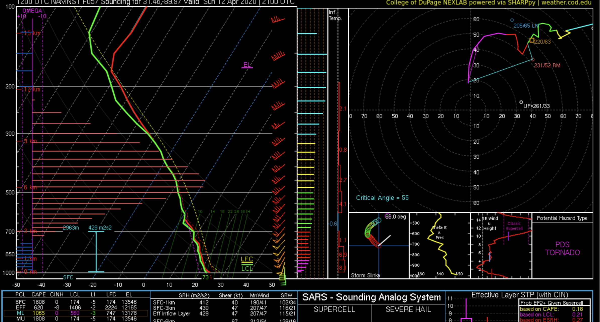
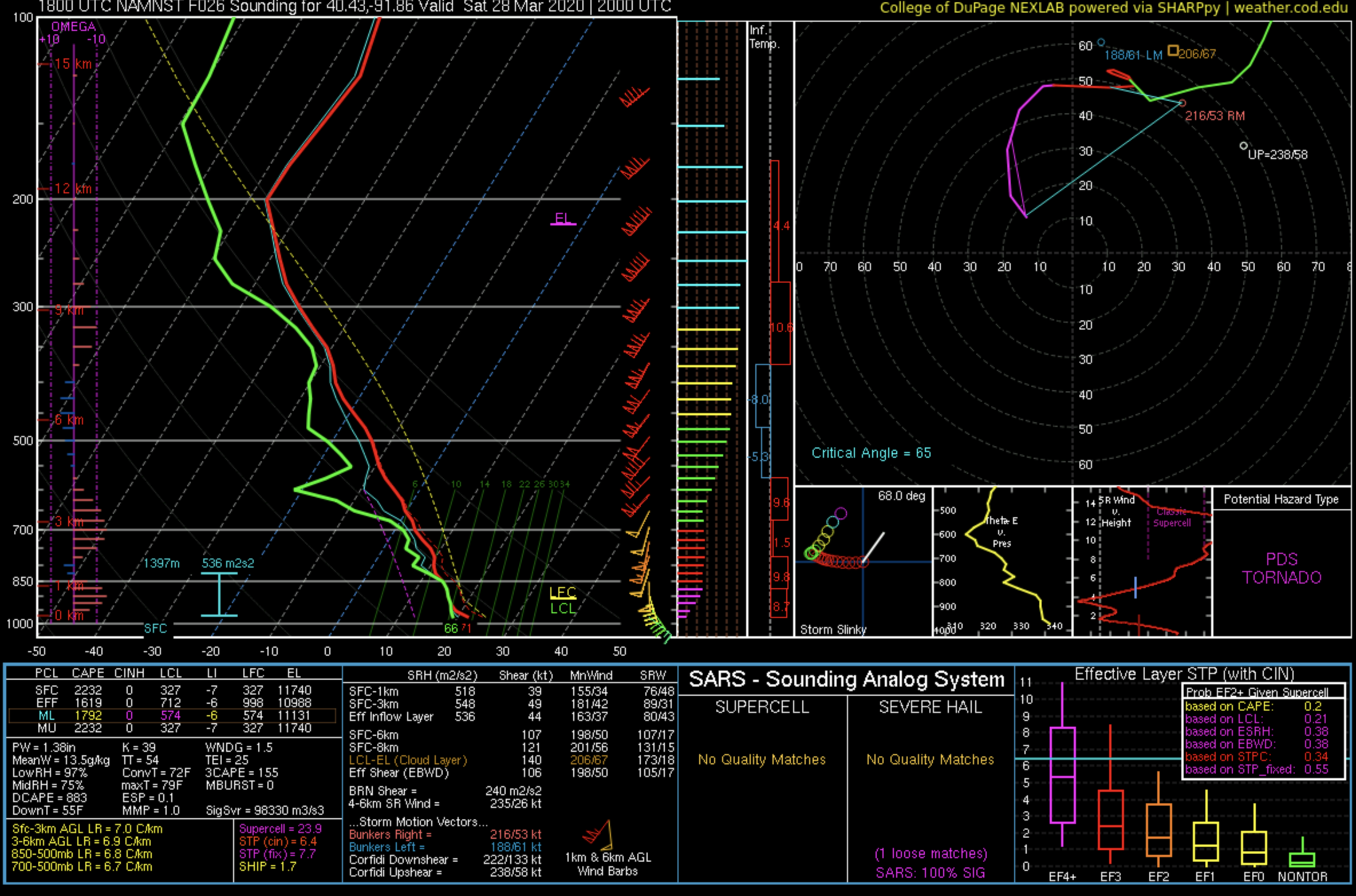
Here is a similar looking sounding from the warm sector, but showing a descent signature. Same problem with a warm signature at low levels.
Often times wave like ascent/descent signatures form atop the boundary layer in the presence of strong low-level warm air advection. What was probably shown in the previous sounding is the "up" branch of one of these signatures, and this one hows the "down" branch.

-
2 minutes ago, Quincy said:
It’s a convectively contaminated sounding at 23z that’s near a squall line associated with a cold front. The NAM shows multiple rounds and areas of warm sector storms, to the east and several hours earlier.
I don’t think low-level lapse rates are a big issue here. The models show a relatively uncontaminated warm sector around 18-21z. You can get QLCS tornadoes even with the surging cold front, but I’d be more focused on the warm sector and any pre-frontal trough.
For the record, the ascent you are seeing at low levels in that sounding is associated with warm air advection - not "convective contamination."
Edit: I merely stated what the NAM NEST showed, not what "will happen." But the NAM nest shows this warm signature broadly through the warm sector at various times and in regions sufficiently far from ongoing deep moist convection to avoid convective contamination. Correspondingly the model does not show any CI in the warm sector. We've seen this signature in the NAM nest for other would-be big events that busted. So it's not something to be discounted because of incorrect notions about convective contamination.
-
 1
1
-
-
6 minutes ago, crossbowftw3 said:
Lines on the left give the big hint. This sounding is excessively containinated
The lines on the left show ascent related to warm air advection (not convection). Also, you'll notice that the sounding looks early identical to those in the post subsequent to mine.
Now this (attached) is an "excessively" convectively contaminated sounding. Note the saturation through most of the column and strong ascent at mid-to-upper levels that does not coincide with vertically decreasing warm air advection (as QG theory would suggest for WAA induced ascent).

-
34 minutes ago, Upper Level LOL said:
This is a convection contaminated sounding
How do you figure? There is only a saturated layer at low levels.
Also, this saturated layer is prevalent everywhere (not just in the example I showed). The presence of saturation in a sounding does not necessarily imply convective contamination. -
1 minute ago, StormySquares said:
Isn't linear solutions a bias the 3KMNAM has? Should it be taken with a grain of salt?
There isn't any science that supports this alleged bias.
However, you are right that CAM solutions at this point should be taken with a grain of salt. I think this run showed us a potential bust mode, but that doesn't mean that it will actually pan out.
The dynamics in this run also support a linear solution, with storm motions that are largely parallel to the front and shitty 0-3 km lapse rates in the warm sector. So I wouldn't think of this as a bias. -
IMO, there are still a lot of question marks here. I think MOD day 3 was a good call by SPC given the potential upper envelope, but if other CAMS show similar trends to the NAM NEST, we won't see an upgrade to HIGH tomorrow.
-
2
-
1
-
-
9 minutes ago, Bob's Burgers said:
Big-time UH swaths coming off the NAMNEST

These UH swaths are all occurring on a progged QLCS along the cold front, and are not related to discrete supercells.
Edit: It also seems like a preponderance of cold front parallel storm motions could be an issue here.
-
1
-
-
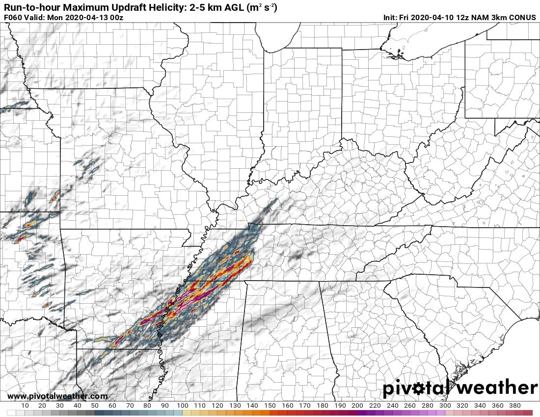
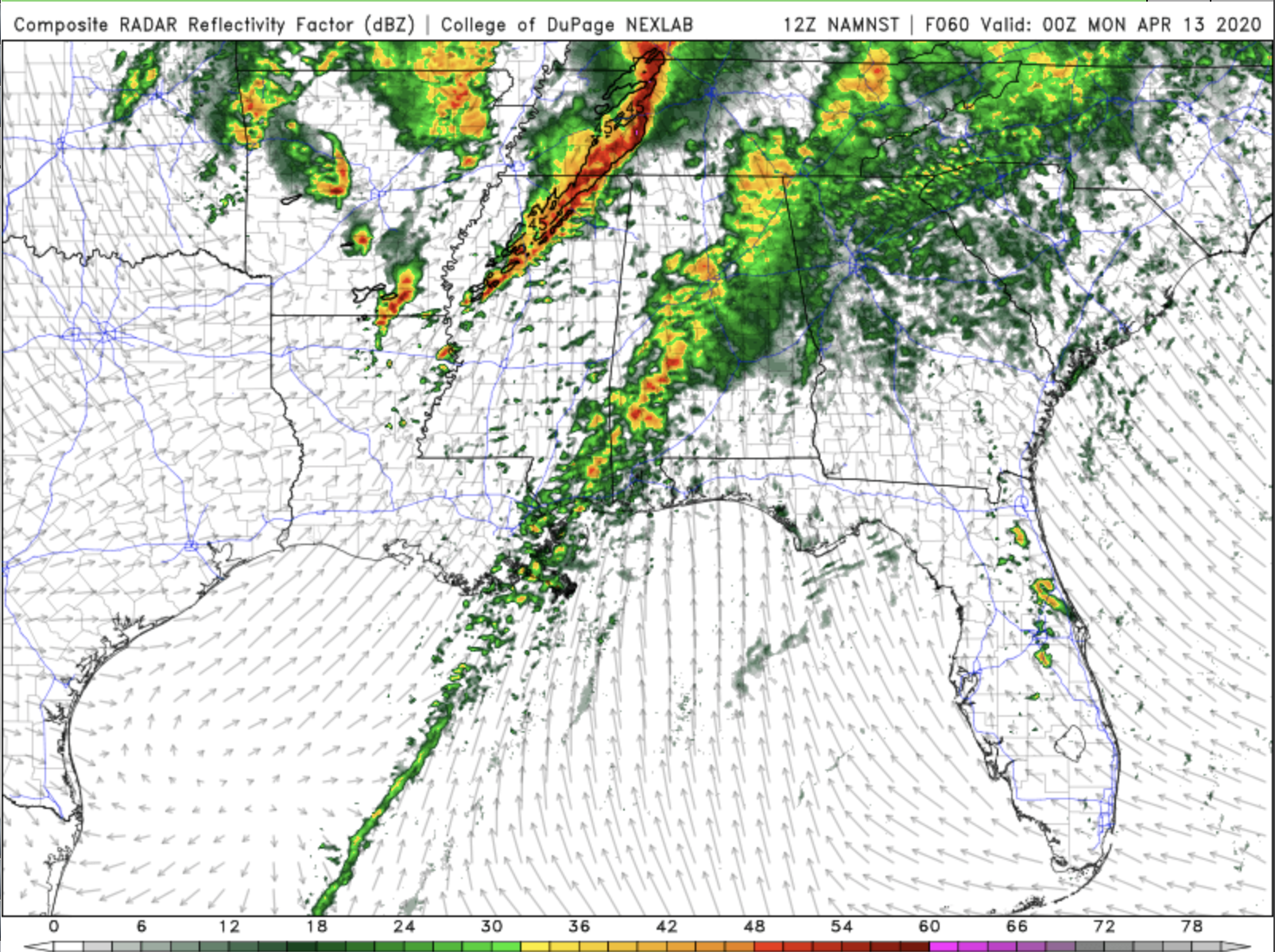
the 12 UTC NAM Nest is showing a substantial warm layer below 700 mb, and almost now buoyancy for a lifted parcel below this level. Relatedly, there is almost no discrete convection that breaks out in the warm sector. Rather, everything seems confined to a cold frontal QLCS and a wave of convection proceeding the warm sector. The latest NAM proper run is a bit cooler between 900 and 700 mb and indicates an outbreak.
This seems like at least one potential "bust" mode.
-
10 minutes ago, joshwx2003 said:
Try Historical.I have a feeling that this will be the worst tornado outbreak in history for the US.The models show no convection in the morning and just insane parameters which will setup a worst case scenario.
Please don't post things like this. While some of the projected environmental parameters look impressive, they already don't look as impressive (less CAPE) as events like 4-27-11. And 4-27-11 didn't even quite reach the scope of the super outbreak in 74. I don't think there is any indication that this will exceed the spatial coverage or intensity (number of EF-4+ tornadoes) as either of those outbreaks.
And if there is anything the last few years have taught us, there are plenty of ways for a potent looking event 2 days out to end up busting.-
9
-
4
-
-
6 minutes ago, Chicago Storm said:
While true, if it is a continued issue, it has also proven to also be a mitigating issue in significant/sustained severe.
...Which we have seen plenty of times before.
I agree, I think it might be mitigating development in this case.
Edit: now seeing tops approach 35 Kft in the vicinity of Des Moines, and storms are looking healthier. We shall see.
-
I've done work in this area. Strong shear makes convection deepen at a slower rate:
https://journals.ametsoc.org/doi/abs/10.1175/JAS-D-18-0296.1
-
5
-
-
This is the inflow sounding to one of the HRRR projected cells in western IL. All of you who think this will be a bust are totally fried.
-
1
-
 1
1
-
-
10 minutes ago, DanLarsen34 said:
Murphy’s law has applied to these past couple of big on-paper set-ups. Everything looks a go until we get to the day of. Not saying this set-up can’t still be potent today, but it looks a lot less certain that we’ll be seeing an significant outbreak than it did 24 hours ago.
I don't think this is entirely true. Both the GFS and the NAM/NAM nest, along with the euro intermittently showed solutions over the past few days akin to what the HRRR is showing today. There were certainly uncertainties going into this event, and it was never a "slam dunk." A lot of the hype originated from the HRRR runs before and at 00 UTC.
-
1
-
-
FWIW, the 10 UTC HRRR is backing off a bit on junkvection and moving back toward a volatile environment in NW IL and NE IA. So those of you who think this needs to be backed down to a MRGL risk with 2 % tornado probabilities should settle down a bit...
-
Just now, Quincy said:
Verbatim, it keeps the warm front down around US-136 through about 19-20z. A lot of that early convection quickly advances over the warm front. Elevated convection/hail threat.
Dew points are about 3F lower than the HRRR, but the parameter space around the NE MO/SE IA/NW IL area is still highly supportive for tornadoes.
After a bit of staring at the NAM and RAP, i think I see what the difference is. The NAM (and consequently NAM NEST) develops more early morning convection/precip over AR/MO, which creates a subtle shortwave vort max in the jet. As this feature passes over the warm sector, there is a bunch of junkvection that forms. In contrast, the RAP (and consequently HRRR) seems to keep AR/MO comparatively clear of convection and has no commensurate shortwave feature. This leads to a less junkvectiony warm sector.
-
6
-
1
-
-
Forecast sounding near the projected warm front in IA tomorrow from the NAM nest. Obv this is a difficult-to-believe forecast sounding, but it has to be the most incredible kinematic environment I have ever ever seen. 100+ kt of 0-6 km shear, combined with 500+ J/kg of 0-1 km SRH??? 48 kts of 0-1 km SR flow? Totally unreal.

-
4
-
-
4 hours ago, NJwx85 said:
With the exception of Dorian and Lorenzo, every other storm this season has struggled. I think it has more to do with the strength of the vort as it came off of Africa and favorable UL conditions in the Eastern Atlantic as opposed to some anomalously high SST in that area. It’s not like every wave coming off of Africa in that spot has developed, in fact it’ll likely be the only one this year.
SST anomalies in the area that the storm RI'd are on the order of + 1-2 C.
The storm had also been experiencing relatively large (e.g. 20 kt) shear during this time, so it's not like synoptic conditions were exceptionally favorable. You're probably right in that this system found a local "hole" in otherwise hostile conditions to intensify, but this was probably facilitated by warmer than normal SSTs.

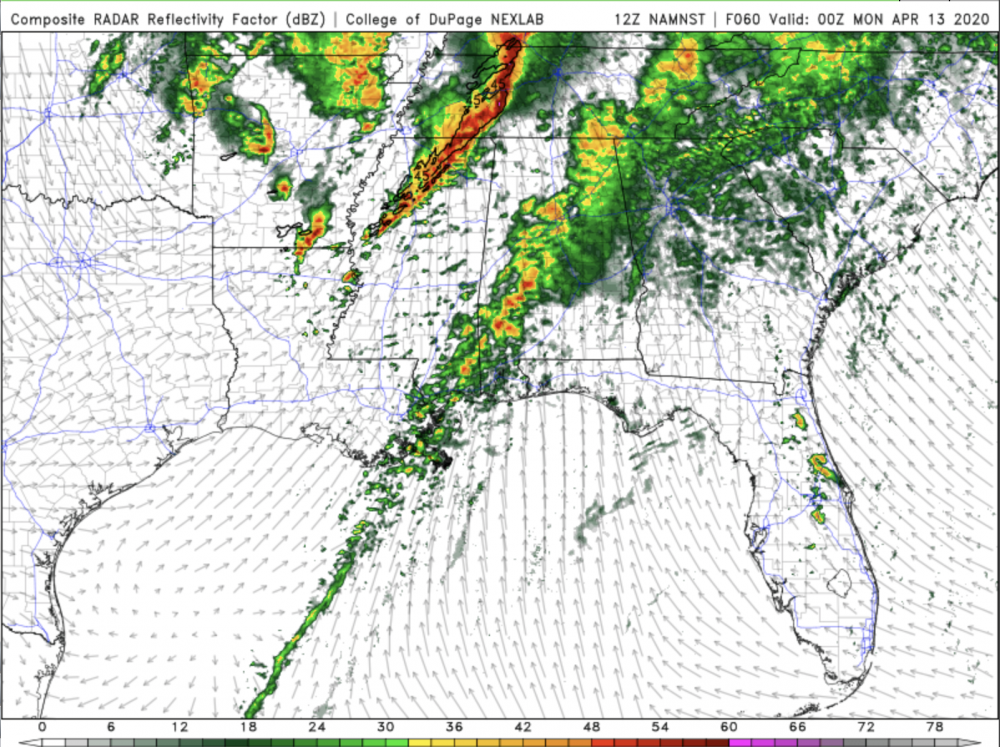
April 12 Severe Event
in Southeastern States
Posted
I agree with this 100%. Particularly in supercell and tornado environments, MLCAPE seems to be a better outcome discriminator than SBCAPE. While a few degrees of dew point at the surface may substantially change the lifted parcel path of a SP parcel, the probably won't impact MLCAPE much. So the low-level lapse rate issue is certainly a potential bust mode.