

jpeters3
-
Posts
736 -
Joined
-
Last visited
Content Type
Profiles
Blogs
Forums
American Weather
Media Demo
Store
Gallery
Posts posted by jpeters3
-
-
FYI, Trotwood tornado from 5-27 upgraded to EF-4.
https://mesonet.agron.iastate.edu/wx/afos/p.php?pil=PNSILN&e=201905302115
-
6 minutes ago, Buckeye05 said:
Well if there's research to support it I acknowledge that (most violent tornadoes are indeed wedges), but I'm saying width is not factored in when it comes to the actual rating process. The above poster seemed to think it was for some reason. No surveyor says "well we have to rate it EF3+ because it was a wedge".
This is true. While they are correlated, I think there have been a few EF-2 purported wedges over the past 10 days (e.g. Mangum OK, Canadian TX).
Edit: I know both of these tornadoes were observed by DOWs. It will be interesting to see what the radar data says.
-
7 minutes ago, Buckeye05 said:
Size/width has nothing to do the Enhanced Fujita scale rating. Come on now, surely you know that?
It's quite probable that the two are related (i.e. width and intensity are correlated). I'm fairly sure I've seen some research evidence to support this.
-
We all know how useful it is to argue about EF-scale ratings based upon extremely limited information...

Lest just wait for the survey, eh???-
 2
2
-
-
24 minutes ago, snowlover2 said:
A few minor injuries but no fatalities.
This is great news. I was a bit worried last night.
-
Any reports of injuries/fatalities from the Dayton storm?
-
-
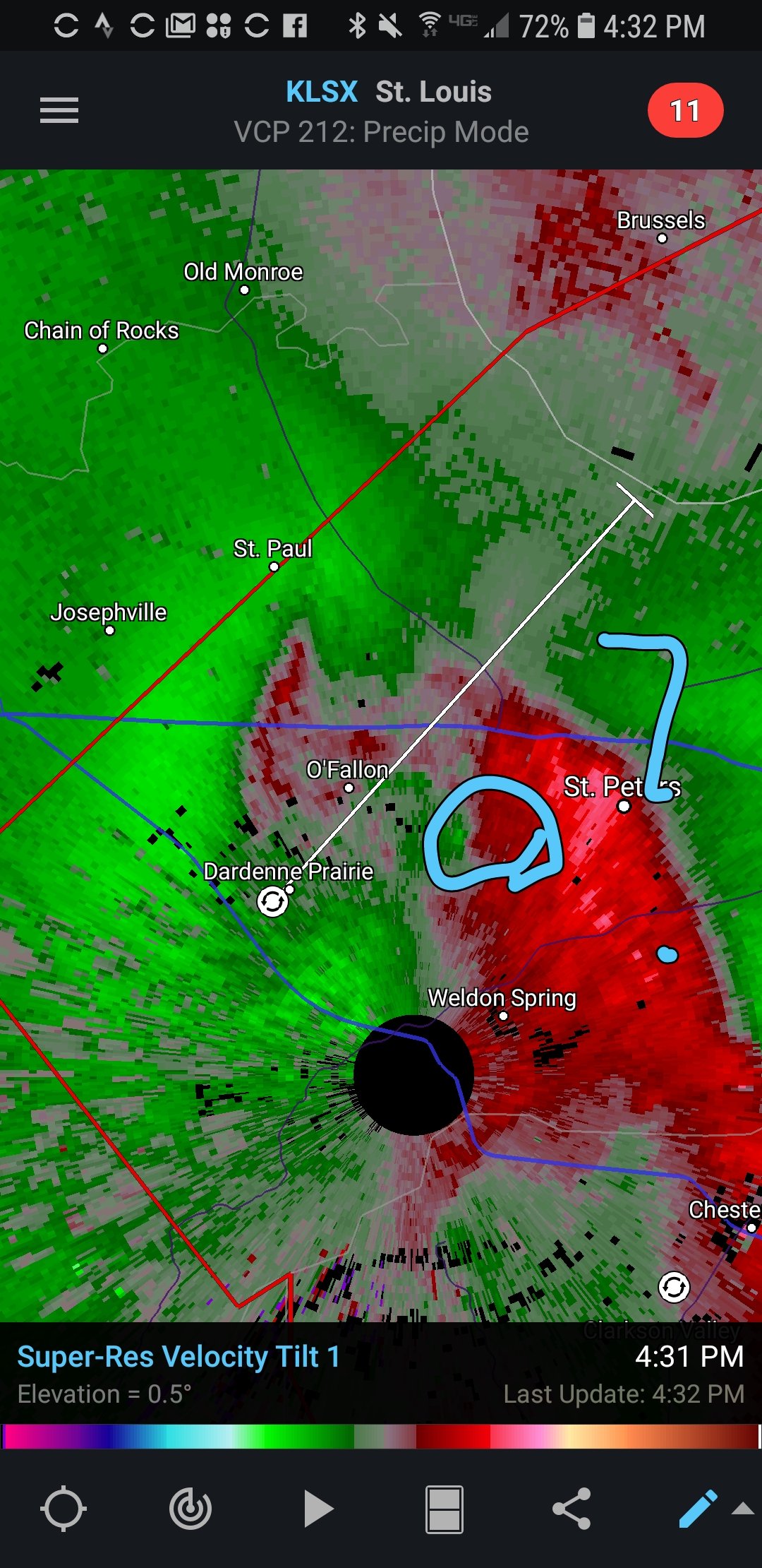
Some weak circulation to the north.

-
VWP observed low-level wind profile is quite impressive.

-
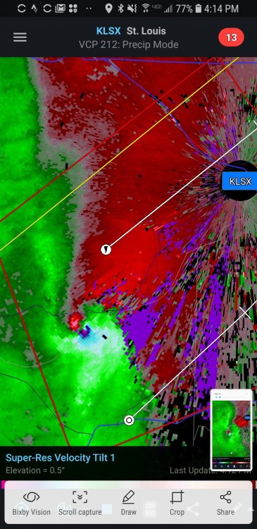
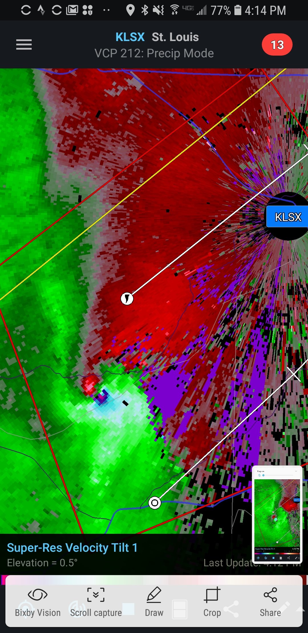
Just now, janetjanet998 said:
still on ground
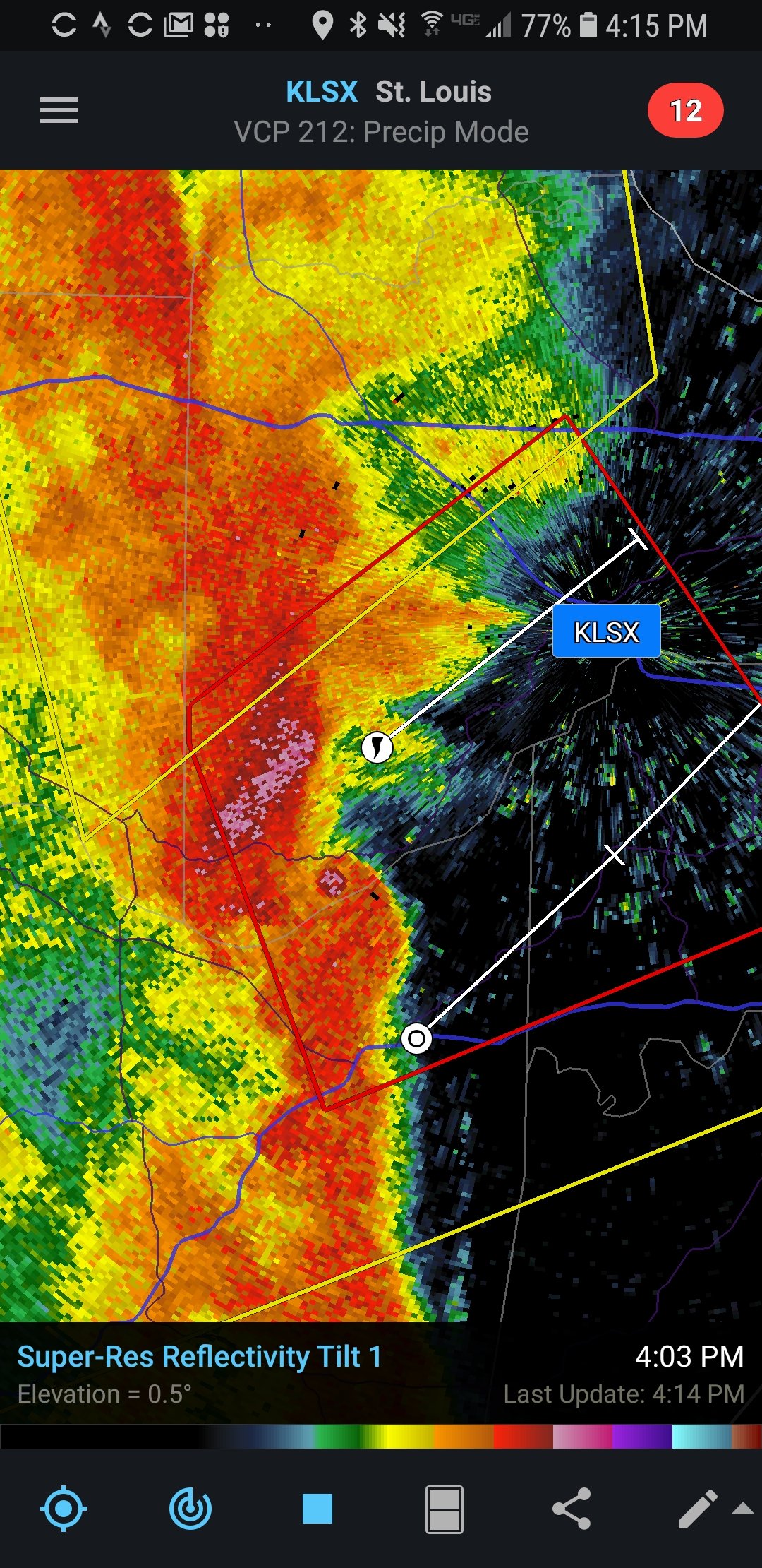
MOC183-189-212330-
/O.CON.KLSX.TO.W.0013.000000T0000Z-190521T2330Z/
ST. CHARLES MO-ST. LOUIS MO-
624 PM CDT TUE MAY 21 2019
...A TORNADO WARNING REMAINS IN EFFECT UNTIL 630 PM CDT FOR WEST
CENTRAL ST. CHARLES AND WEST CENTRAL ST. LOUIS COUNTIES...
AT 624 PM CDT, A CONFIRMED TORNADO WAS LOCATED OVER HARVESTER, MOVING
NORTHEAST AT 45 MPH.
HAZARD...DAMAGING TORNADO AND PING PONG BALL SIZE HAIL.
SOURCE...WEATHER SPOTTERS CONFIRMED TORNADO.Seriously doubt it. No evidence of this in radar.
-
Just now, janetjanet998 said:
I think it was a semi embedded supercell for a bit..had a huge hail spike right before it dropped
Yeah, the distinction between QLCS tornadoes and "embedded supercells" is a bit vague sometimes. Rare that you see a spin up that strong embedded within the middle of a squall line though.
-
Tornado definitely dissipated. Very close call.
-
Just now, Calderon said:
The circulation looks to have completely fallen apart very rapidly as it is moving into Weldon Spring right now.
Thankfully. That was a really close call. Looks to have been a very intense tornado for a few minutes there.
-
That was one heck of a QLCS tornado. Produced a massive debris ball.
-
What the hell just happened....

-
6 minutes ago, nwohweather said:
I feel bad for those guys. One of the most advertised outbreaks of the decade completely flops. Not saying today hasn’t been active but this certainly wasn’t historic
In their defense, I think pretty much everyone was taken off guard.
-
southward surging ofb
-
Folks, from an objective perspecitve, this is a bust. There are few scenarios whete the high risk will verify. No signs of CI in the warm sector and a robust MCS that is being overrun by an OFB. Just calling a spade a spade.
-
2
-
-
Just now, CryHavoc said:
Way too early to say that. It's not even 5pm CDT.
Considering the fact that there had already been several EF-5s on 4-27 by this time, I think this statement is well justified.
-
3
-
-
also some CI down to the SE of Lubbock near the dryline.
-
47 minutes ago, jojo762 said:
Most of the 12Z CAMs caved to the HRRR and depict numerous discrete supercells across the high risk area later this afternoon. Buckle up. Scary day evolving for OK and TX.
Even the NAM NEST has caved a bit. At this point, i would discount that solution anyway since it has very poorly handled MCS development/movement earlier in the day.
-
1 minute ago, MattPetrulli said:
Important to note 3k NAM has been NOT a good model this year.
This statement isn't at all quantitatively supported. Also, nobody is jumping on the NAM nest solution as the most likely outcome.
-
 1
1
-
-
4 minutes ago, jojo762 said:
You realize an hour ago that meteorologists far more experienced than anyone in here extended that high risk to include them, correct? Look at literally every other portion of the high risk and there is zero meaningful deep convection.
Just let us objectively assess the situation. Nobody is prematurely calling bust at this point, we're just calling it as we see it and you haven't the faintest idea how much experience any of us have.
-
3
-
-
Just now, bjc3395 said:
So you’ve got more experience than me. In a typical Plains setup i would agree that MCS in NW OK pretty much confines the front to I-40, maybe even S. But.. this is anomalous for the Plains. Would argue the LL flow keeps that boundary N of 40.. perhaps closer to 412. Your thoughts from experience?
I think it's too early to tell at this point. The current trend is basically between the bullish HRRR solutions and the Bustish NAM NEST solutions. Both models show the outflow boundary from early activity "holding latitude" against the southerly flow.

Major Hurricane Lorenzo
in Tropical Headquarters
Posted
It is possible that the recent large number of cat 5s has something to do with warming SSTs. I would argue that this particular storm might be the most unusual out of the bunch given the intensity it achieved at such a northeasterly position relative to past storms. This may reflect SSTs being warmer in this part of the ocean than in the past, facilitating RI.