

jpeters3
-
Posts
736 -
Joined
-
Last visited
Content Type
Profiles
Blogs
Forums
American Weather
Media Demo
Store
Gallery
Posts posted by jpeters3
-
-
5 minutes ago, DanLarsen34 said:
Doesn’t seem like anyone has been bullish on this set-up after the past few model runs. Too many failure modes evident to get very excited about this.
Yeah, i think we are pretty much all in agreement here.
-
 2
2
-
-
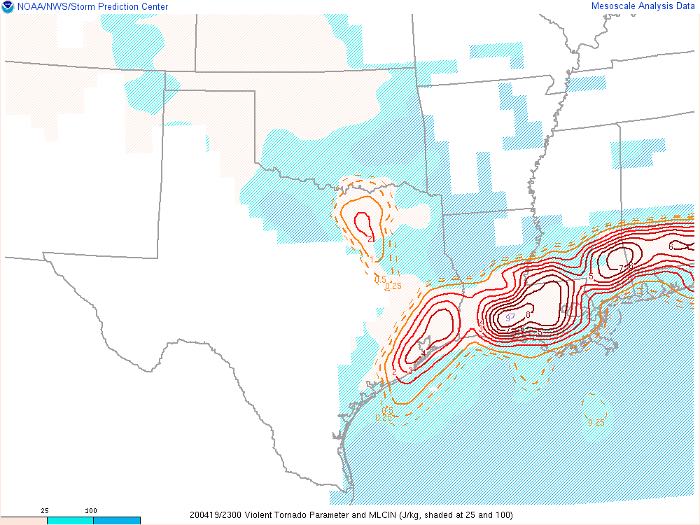
I'm not very optimistic given this first round of CAM solutions. Most show a fairly large MCS overspreading the region early in the day, and a large removal of surface-based instability. Even in the 3 km NAM, the cells that erupt within the region where recovery occurs don't encounter very favorable low-level wind profiles, which is presumably due to the disruption of the LLJ by the proceeding MCS. Given the propensity for CAMs to under-estimated southward MCS extent, I think the MCS scenario would end up being a near total bust in terms of tornadoes.
-
2
-
-
11 minutes ago, Bob's Burgers said:
The thing that is interesting to me is the timing. If it goes though early (12z or so) and the atmosphere can recover somewhat, couldn't we look at local hotspots with modifying outflow boundaries?
Yeah, the 12z run seems to indicate enough recovery for supercells behind the MCS. Though CAMs seem to always under-estimate the southward component of MCS motion.
-
6 minutes ago, DanLarsen34 said:
This is fine gif.
One thing to watch is that this run shows an early day MCS taking a substantial chunk out of the warm sector, which could end up being a bust mode.
-
1
-
-
this one too:

-
 1
1
-
-
Now there's a wind profile you don't see every day...

-
Just now, Moderately Unstable said:
If I had to guess, looking at the echo tops, these storms probably have stronger updrafts than last week. That would make some sense, we aren't lacking instability. Last weeks storms had more spin and low level shear, but updraft strength wasn't as strong (iirc). Also, what we define as "a lot" is subjective. I haven't seen a "lot" of anything today. A lot of crudvection, yes.
I agree, I think the updrafts are stronger today. More instability, slightly higher tropopause.
-
Just now, Jim Marusak said:
I wonder what's going to be left of the Hattiesburg area after this tornadic storm. the downtown and north side of town is looking at golf ball hail and high winds, the south side, including the airport, is looking they're about to get blasted with either the tornado itself or a pretty nasty inflow wind into this tornado. good luck to them in these next few minutes
I noticed they were betting blasted by hail as well. Interesting, there wasn't much in the way of large hail with last week's storms.
-
Just now, Snowstorm920 said:
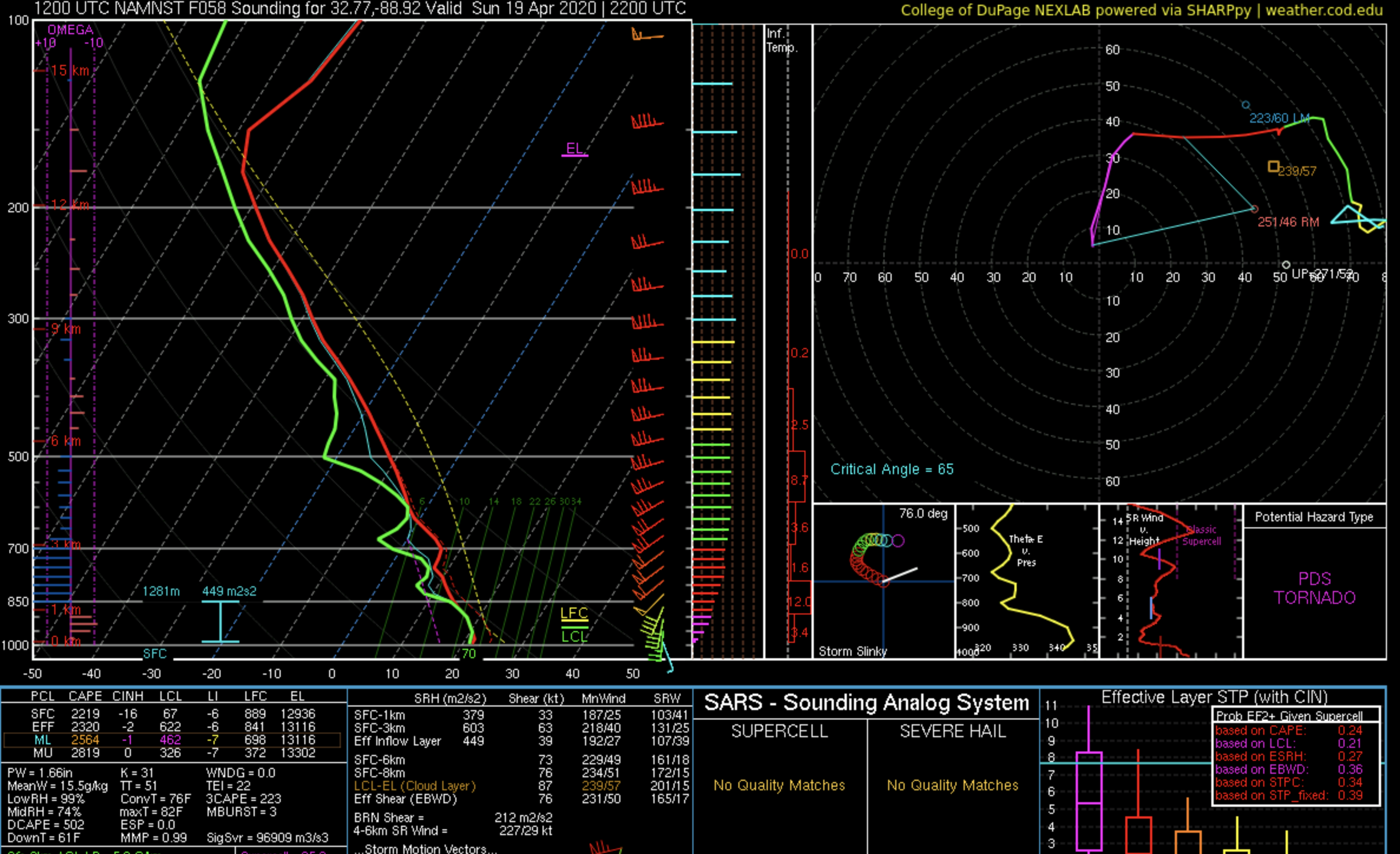
The environment that cell is in is very favorable for strong to violent tornadoes
Not sure. The KLIX profile looks pretty crappy.

-
1
-
-
3 minutes ago, jojo762 said:
It's kinda of odd, I don't recall any guidance yesterday or the day before showing any hint of low-level or mid-level profiles being this awful.
Yeah, this is sort of strange. I remember pulling numerous classic looking low-level hodographs yesterday.
-
 1
1
-
-
1 minute ago, jojo762 said:
Imagine (hoping) that the hodographs INVOF the warm front are better than they are in the open warm-sector, because oof...
KPOE:

KLIX:

KMOB:

Looks like my toddler drew those profiles...
-
2
-
-
1 minute ago, jojo762 said:
Yawn fest so far... for the exact reason as the 00z NSSL-WRF from last night. Just a grungy mess, LLVL wind profile is clearly turning nearly as much as it was on Easter. Likewise still have hours to go, so things could (will) change to some degree.
Funny that the weenies were going nuts this morning about the lack of a High risk call from SPC. Seems like another good forecast on their end, given the uncertainty.
-
12
-
-
1 minute ago, Moderately Unstable said:
Can someone take a look at the storm near Lennox GA and tell me what they think? VAX is showing a TVS but it is far from the radar site.
It appears to be north of two fairly well defined outflow boundaries, so probably sitting over stable air and unlikely to be tornadic.
-
 1
1
-
-
4 minutes ago, janetjanet998 said:
so far surface winds remain veered SW and light
this favors outflow dominated MCS..with meso head spin ups
HRRR seems to continue the trend
edit: surface winds do pick up some here soon
I don't think it's so much the surface winds, as it is the lack of stronger deep layer shear and low-level storm-relative flow (~20-25 kt and ~50-55 kt). Both these measures are considerably weaker than they were for the event last weekend at this same time.
-
One possibly large difference between this event and last week's is the roughly 10 kt difference in 0-6 km shear (weaker today than last Sunday). Low-level shear is obviously most relevant to the immediate process of tornadogenesis through enhancing low-level upward dynamic pressure accelerations, but deep-layer shear (and the associated low-level storm-relative flow) have a strong influence on whether sustained supercells-like updrafts are possible. The comparatively strong deep-layer shear last weekend may have facilitated the formation of sustained supercell-like updrafts within the QLCS, and facilitated the subsequent formation of numerous tornadoes because of the favorable low-level environment. In this event, we will have a favorable low-level environment but not quite as much deep layer shear - this may make all the difference in terms of whether sustained supercell-like updrafts occur within the QLCS and subsequently whether a prolific QLCS event will happen.
-
2
-
-
5 hours ago, CryHavoc said:
I just don't get it.
If we see 60+ tornadoes tomorrow, it's going to be two undersold predictions in a row, all in the name of trying to be careful.Issuing a high risk last weekend would have been irresponsible given the uncertainty. And issuing a high risk this morning also would have been irresponsible, regardless of the outcome.
Yet another difficult forecast this morning. There will be some regions of the warm sector with higher end parameters, but the CAM guidance is far from screaming "outbreak." To me, it looks like we'll have another QLCS event with the chance of some rogue isolated supercells in the warm sector (though CAMS are all across the board in terms of the prevalence of the later). QLCS tornado events are quite difficult to forecast. Obviously last week's event was prolific, and there are some similarities this week (low-level saturation). But there have been plenty events with high end parameters in the warm sector and a QLCS that plowed through the high end parameter region without producing many tornadoes. Given these uncertainties (which to me seem a tad up from last weekend), it would have been totally irresponsible to issue a high risk.-
9
-
-
The first NAM NEST is a similar story to last event. Shows a very volatile environment over LA/MS at 2100-0000 UTC, but mainly grungevection with a trailing MCS, rather than discrete supercells.
Some very impressive looking forecast soundings though.

-
1
-
-
First Bassfield tornado upgraded to EF-3.
https://forecast.weather.gov/product.php?site=NWS&product=LSR&issuedby=LIX
-
1
-
-
1 minute ago, DanLarsen34 said:
Agreed. This will be a good case study for why you don’t need multiple discrete cells to get a major outbreak of strong/violent tornadoes over a large area. A high-end environment in Dixie Alley tends to find a way.
I still find it fascinating how those two monster supercells emerged so quickly out of a cluster of grungevection that I had pretty much written off. You don't see that every day. Obviously the parameters supported such an evolution, but still...
-
4
-
-
1 minute ago, DanLarsen34 said:
Would have verified as a High, but I think SPC forecasters did an excellent job leading up to this event and I agree with their calls the day of. There was a lot of uncertainty, and it was unclear that a widespread outbreak would happen until pretty late in the day.
-
4
-
-
52 minutes ago, joshwx2003 said:
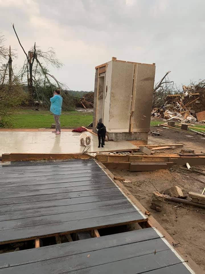
Apparently the tornado that hit Bassfield might break a record that has stood since 2013.Damage swath is 4 miles wide on I-59 at Heidelberg, Miss. MM 115-119. Tornadic wind damage is extensive but there are numerous extreme damage paths about 100-200 yards wide that criss cross each other. Mature pine forests chewed to the ground.
Where did you hear this? Please do share.
-
1
-
-
3 minutes ago, JasonOH said:
I’m going with not at all well built. I see strait nails on the bottom right and it looks like the whole thing is on cinder blocks not anchored to the ground in any way. I don’t see a concrete pad anywhere in the higher res image. There’s a chances they only rate it EF3 depending on the evidence on the ground.

Some of the aerial photos also show very intermittent destruction of houses, which supports the idea that (at least some of) these houses were not well anchored.
-
This comes 15 minutes after the trolls start calling bust...
-
11
-
-
@Quincy
You called this one buddy.-
1
-
April 23rd Severe Event
in Southeastern States
Posted
Watch this turn into a massive outbreak just to spite our well founded hesitance....