

jpeters3
-
Posts
736 -
Joined
-
Last visited
Content Type
Profiles
Blogs
Forums
American Weather
Media Demo
Store
Gallery
Posts posted by jpeters3
-
-
Just now, JasonOH said:
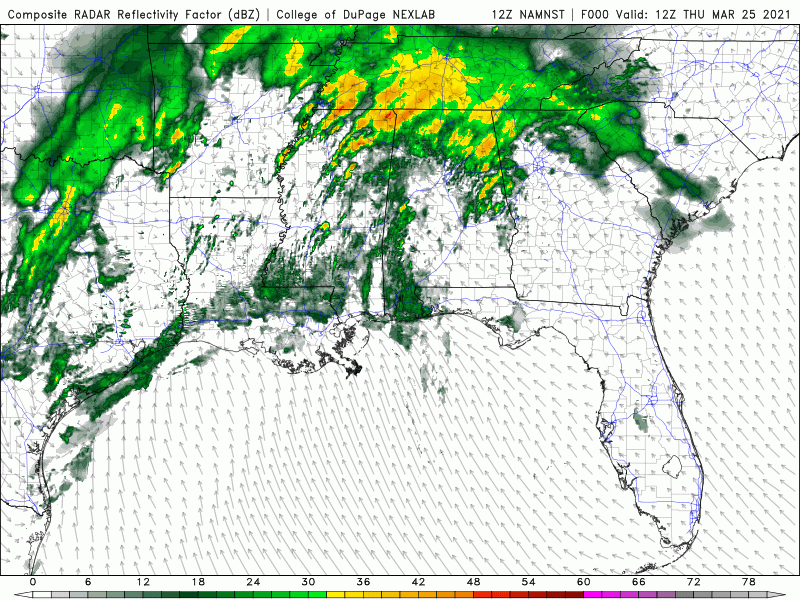
That radar is far enough away for it to not be too useful. Based on BMX, the tornado likely never handed off.
I'm guessing it will be assessed as a continuous track.
-
1 minute ago, David Reimer said:
Tornado just handed off to a new circulation. New significant tornado in progress about a mile east of the old one.
Hard to tell - looks like it might be the same circulation.
-
confirmed, still a wedge on humphree's cam.
-
John Humphress has been periodically showing a massive wedge.
-
 1
1
-
-
this is literally a few minutes after someone called bust
-
2
-
 2
2
-
-
That storm just took a massive hike toward the right as well.
-
1
-
-
Just now, VOLtage said:
Agreed. It's way too early to be calling this a bust.
Same thing happened on 4-12-20, prior to the series of long-tracked massive supercell tornadoes. Also, there's a wedge on the ground in eastern AL. TOO EARLY TO CALL BUST.
-
2
-
 2
2
-
-
Lol, just as the weenies start to call bust, the "junkvection line" starts to turn into supercells. Look at eastern MS
-
12
-
2
-
-
That has to be one of the most stunning chaser feed moments i have seen. I thought he was going to get hit. Thing is moving like a freight train.
-
Just now, SnowWolf96 said:
Hi, does anyone have a link to James Spann live coverage?
https://www.facebook.com/abc3340/videos/301625501323080
-
Looks like the classic enhanced inflow signature had developed that proceeds a big spin-up
-
 1
1
-
-
Just now, Bob's Burgers said:
things are going downhill in a hurry
?
-
The mass of convection that is currently forming in southern MS is a fly in the ointment. This looks similar to what the toned-down 00 UTC HRRR showed, and might pose a junkvection-like mechanism for preventing more widespread stabilization.
-
5
-
-
4 minutes ago, Cyclone-68 said:
Is it safe to presume any tornado watches issued today will come with the PDS label?
At this point we should be focused more on weather outcomes (e.g., strong/violent long tracked tornadoes) than SPC forecast content. Whether or not watches are PDS, or whether or not spc issues a 45% tornado probability, is somewhat irrelevant at this point. These things have no bearing on what will happen.
-
7
-
-
The NAM nest is a bit out to lunch on early day convection, but has gone all in on the outbreak scenario.
-
5 minutes ago, olafminesaw said:
Kinda surprising they didn't go with 45%
This is inconsequential. The discussion speaks for itself.
-
2
-
-
2 minutes ago, Chip said:
Concerning? Very! Is there anything at all at this point that could throw a wrench in this?
There always is. Too much convection blowing up too early in the warm sector could substantially reduce supercell coverage, for instance.
-
Just now, Bob's Burgers said:
Both the 7z hrrr and the latest 11z hrrr... yikes
All of the latest ones are pretty darn concerning, eh?
-
1 minute ago, Chip said:
So what is the ceiling here?
The ceiling is certainly a historic, and unfortunately destructive and deadly, outbreak.
-
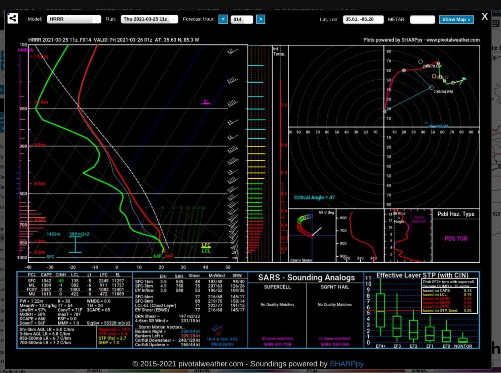
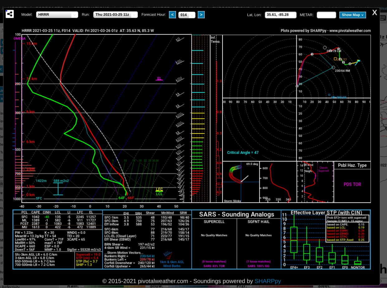
After the brief lull at 00Z, the HRRR is back to apocalypse mode. Pretty scary convergence of model guidance on what looks like a a worst case scenario...
-
1 minute ago, Quincy said:
The 00z 3km NAM is either scary af, clueless or both. I cherry picked some soundings with 700-500mb lapse rates over 9 C/km with Tds in the lower 70s. Even area averaged soundings show lapse rates around 8 C/km with a small capping inversion. Important note is that low level lapse rates in this environment are marginal, in some cases <6 C/km.
If the cold bias is correct, you’d have that tiny cap being obliterated.
Is it overly simplified to say a HRRR/3km NAM blend is one of the scariest scenarios you could fathom? HRRR is messy with widespread convection, while the NAM is just a little bit too cool in the boundary layer, resulting in very little warm sector convective initiation.
IDK, let me consult COAMPS

-
2
-
-
1 minute ago, jojo762 said:
I wanted to be that aggressive with calling out how awful/suspect that thermo profile looked (from a forecast output perspective), but I couldn't.

Fairly sure no observed sounding has ever looked like that
-
1
-
-
1 minute ago, Bob's Burgers said:
and that would be why there is nothing

Yeah, can we talk about where the hell these profiles came from??? Calling BS on this solution...
-
3
-
-
Nam nest says "hold my beer."
Produces a warm sector with widespread 0-1 km SRH > 600 J/kg and 80-100 kt 0-6 km BWDs, but not one supercell or UH track over MS/AL. Not much convection at all. So much for CAMs making things clearer for the 06 UTC outlook.
-
5
-
Severe Event March 25th 2021
in Southeastern States
Posted
I would be incredibly surprised if this one wasn't also an EF-4 (or 5).