

Allsnow
-
Posts
23,646 -
Joined
-
Last visited
Content Type
Profiles
Blogs
Forums
American Weather
Media Demo
Store
Gallery
Posts posted by Allsnow
-
-
7 minutes ago, rossi said:
All we need is 50 to 100 mile east movement and we all get plastered
That would not change the fact that we have a onshore flow with a bad airmass. This is rain regardless for the coast. Northern Pa and Upstate ny have the best shot.
-
 1
1
-
-
8 minutes ago, Snow88 said:
Gfs is really good for the interior

Perfect low track for the metro area and 100% rain. Shades of 97-98.
-
 1
1
-
-
30 minutes ago, HVSnowLover said:
You don't need an artic high to snow in the middle of winter, we've seen places to our south and east get a snow event two weeks ago. You just to get lucky with a storm track here or there, overall most storms will track to our NW but it can still snow in a bad pattern especially in the middle of winter
Like it snowed yesterday in a bad pattern with a arctic high.
-
Mjo still looks to get into 7/8 to start February then the kelvin wave gets stronger in p5. Lots of substance in p6 so would not be shocked if that wave collapsed into cod

-
1
-
 1
1
-
-
4 minutes ago, Mersky said:
Ask people in DC if they would change anything about 2009-10. I doubt you will get many complaints that December and January were slightly above normal. Truthfully how many winters are wall to wall cold around here??
Outside winters like 95-96/13-14 not many. That’s why we avg what we avg here for snow. I don’t follow why I need to survey people from DCA about winter 09-10? All I’m saying is that was Nino climo helped by a uber block in February and December.
-
Just now, Mersky said:
Sir you are proving my point and you don’t even know it. 82-83 huge February snowstorm. 2009-10 huge mid Atlantic winter for snow. It can snow when it’s warm up north.
If proving your point means the next two weeks look meh for snow and canonical nino is warm north/cold south, then sure. Obviously, those last two posts from you were trying to twist my words.
Let’s not forget about the uber blocking in 09-10 in a otherwise warmer then normal winter. December 09 and January 10 were above Avg with little snow outside December 20 09.
-
 1
1
-
-
3 minutes ago, Mersky said:
It was warm up north in 2009-10. Rained in Maine while DC had their snowiest winter ever. Your point???
1 hour ago, Isotherm said:Yes, I agree with your post here and the others recently. Regarding the putative canonical Nino-look and seasonable temps in the South, that doesn't necessarily imply favorable pattern for snow in the Northeast I-95 corridor. Classical Ninos are typically seasonable temperature wise across the southern tier of the CONUS due to frequent clouds and precipitation.
For example, see 97-98, which wasn't a torch for the southern half of the country, but it certainly wasn't snowy for our region.

Similar look with 1982-83.

-
8 minutes ago, Mersky said:
Wait wut? Loop a operational model past 5 days?? Lol and you are 100% wrong on the strength of the nino not making a difference in temps.
For the next two weeks it fits the h5 pattern well. A moderating northern tier with a active progressive stj. Just because it doesn’t show what you want doesn’t make it wrong.
Yes, in that moderate 09-10 nino it was bitterly cold up north.

-
5 minutes ago, Mersky said:
Yes those 20’s in Canada will be hot for sure
Yep, about on par for a normal high in areas north of nyc.
-
12 minutes ago, Isotherm said:
Yes, I agree with your post here and the others recently. Regarding the putative canonical Nino-look and seasonable temps in the South, that doesn't necessarily imply favorable pattern for snow in the Northeast I-95 corridor. Classical Ninos are typically seasonable temperature wise across the southern tier of the CONUS due to frequent clouds and precipitation.
For example, see 97-98, which wasn't a torch for the southern half of the country, but it certainly wasn't snowy for our region.
Similar look with 1982-83.
Yep. @bluewave made a terrific post about the +AAM and ridge by Hawaii. This played a big part in the colder pattern going poof.
As you have said recently you can’t have biases in weather. If the pattern looked cold and snowy we both would be posting about it.
-
2
-
-
1 minute ago, Mersky said:
97-98 was a strong nino. Of course the country torched. You can’t compare that nino to this one.
No matter the strength of nino the result is warmer northern tier with cooler south. With the vortex in AK it’s even worst. Just loop the 18z gfs it illustrates the up coming pattern very well.
-
3 minutes ago, binbisso said:
Yes that's because the primary was north of Detroit. If the system next week stays under us we could have Frozen even down to the coast
I was referring to his statement about how Arctic air in January keeps storms to are south.
The system stays to our south on the 12z euro and the big city’s along 95 get nothing but rain. -
I’m not trying to rain on anyone’s parade. It’s a weather forum and you can track whatever you want. Imo the pattern looks unfavorable for significant snow in nyc for the next 2-3 weeks.
-
2
-
1
-
-
12 minutes ago, Snow88 said:
Agree
We dont want arctic air this time of the year. If so then congrats DC.
That’s simply incorrect. Having arctic air yesterday was the only reason you snowed.
-
1
-
-
17 minutes ago, Mersky said:
So a well timed high during a otherwise above normal regime led to snow yesterday, correct??
Yes. Because we had very cold air in Canada. I don’t see that In the next two weeks of January. The vortex and ridge in Hudson Bay will moderate Canada quickly.
-
1
-
-
6 minutes ago, Snow88 said:
Eps is +1 for the temp anomaly for day 10-15. That will work fine in January.

That’s Celsius Anthony


-
 3
3
-
-
3 minutes ago, Snow88 said:
People said the same thing about this timeframe and look , many coastal regions saw snow yesterday.
Eps is +1. That isnt a torch in January.
The storm this weekend is really close doe everyone .
Disagree. I remember posting about a over running threat last Saturday when it was in the 70’s. I even posted how the news will have that classic split screen weather segment. The cold artic high pressure was the only reason we snowed in yesterday’s set up.
-
1
-
-
Okay. This was the exact tweet. I agree for North Carolina it’s not a torch. It will be too stormy down there with a active STJ which will keep temps around normal. Imo that tweet has nothing to do with areas outside the southern US.
-
1
-
-
5 minutes ago, Mersky said:
That is still below freezing air in Canada. I know people love to look at the pretty red colors and think it’s a torch but it isn’t. A well timed high pressure system and a low coming across the south, which that clearly shows is a split flow, could still cause snow this time of the year. If that map was in early December or March then no. But marginal air masses can work in late January, early February.
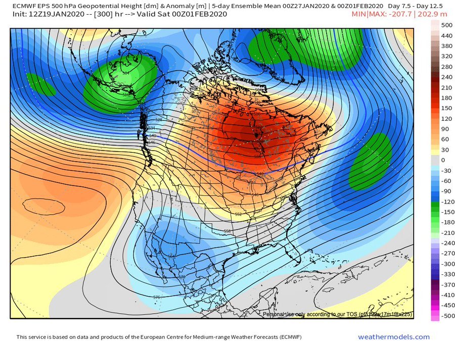
It would be a torch if we didn’t have a split flow. That ridge from Hawaii would be in the plains instead of the west coast. It’s not a torch but above normal for the majority of the conus. I expect very little for the coastal plain the next two weeks. The interior and nne is a totally different story.
-
1
-
1
-
-
6 minutes ago, Snow88 said:
With a storm threat next weekend. Not bad at all.
Nws mentioned about possible secondary development over the Carolinas.
We have a very marginal airmass with no artic air around. The eps mean has less then a one inch for our area. Those numbers increase out by northern Pa and upstate ny.
So in short, I would be shocked to see next weekend workout for the costal plain.
-
2
-
1
-
1
-
-
1 minute ago, Mersky said:
That isn’t a torch either so Webb is correct.
I didn’t say it was a torch but very much above normal. That’s a 7 day mean and after Thursday we don’t have another below normal day. (If correct) I don’t know what exactly Webb said so I’m not going to question it.
The flow looks very progressive with above normal temps the next two weeks.
-
1
-
1
-
1
-
-
5 minutes ago, Snow88 said:
Eps has been awful this whole season and yet people praise it all the time.
This is simply incorrect. It hasn’t been any worst then the other guidance. The GEFS have been too cold in the long range.
-
1
-
1
-
-
6 minutes ago, Snow88 said:
Really because Eric Webb think the eps doesnt look bad at all.
The Atlantic doesnt look bad at all
I don’t know what he is saying but that is a ugly look on the eps. Vortex in ak with a +nao. The only thing that makes it cooler by him is the split flow. If that’s what he is saying.


-
1
-
1
-
-
23 minutes ago, Isotherm said:
Thanks, Chris. And great explanation above as well. Another factor supporting the notion of potentially a better window of opportunity late Feb-Mar is the wavelength alterations. The shorter wavelengths in late winter-March can often render than base state -PDO/-PNA less influential. I do not have the data in front of me, but I would wager to assert that a proportionally higher % of snow events in March featured a -PNA compared to Dec-Jan-Feb. @uncle W may have those statistics.
Until late February, we may continue to battle this unpropitious base state.
Yep. I’m pretty sure we gain a phase of the mjo that is cold in March. I believe it is p3.
Another year with a favorable mjo pass that will result in a unfavorable response. We could see some hits on the Pv starting in mid February that will line up with your timing well.
-
1
-


Wet snowstorm potential Jan 25-26, mainly high terrain northwest of NYC
in New York City Metro
Posted
Similar to the cmc. Snow is restricted to NNE.