-
Posts
23,654 -
Joined
-
Last visited
Content Type
Profiles
Blogs
Forums
American Weather
Media Demo
Store
Gallery
Posts posted by Allsnow
-
-
Just now, snowman19 said:
I like HM but he busted very badly so far. He called for a very cold and snowy December and January with massive -EPO and +PNA blocking, he also called for a continuation of cold/snow through February. It hasn’t been a good winter for him at all
Anyone that has gone cold and snowy for this winter has had it rough. My point of posting his tweet is that I agree with him. Does it mean 40 inch February for Knyc? No! All I’m saying is I don’t think February will be a all out disaster. (like January) IMO February should offer some chances. It was obvious last week (I posted such) that January was toast.
-
 2
2
-
-
-
Mjo won’t rule the roost
-
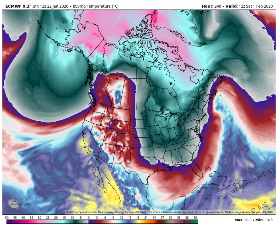
I still think our chances will go up for snow around the 5th. The airmass will greatly improve. Signs of the trough pulling back west between the 10-15 of February. But that’s so far out in time it will probably changed. I continue to like the disruptions to the Pv we are seeing for February.
-
 1
1
-
-
-
Interior should be excited with this setup
-
 1
1
-
-
1 hour ago, jm1220 said:
If there isn’t a good PNA ridge and/or some blocking, this will likely end up over Detroit. I’m more interested in those over any particular storm.
48 minutes ago, snowman19 said:The EPS was definitely huggy
We look to have a good pna next week. The airmass and position of ridge will be key. A costal hugger or a apps runner isn’t a cutter. I doubt we see a cutter in this pattern.
-
 2
2
-
 1
1
-
-
Getting out there in the uber long range but I like the 5th-8th timeframe. Better airmass with some blocking.
-
4 minutes ago, ORH_wxman said:
The euro ensembles definitely still look a lot better going into early February. No negative changes today. In fact, there's early signs of a -NAO in the 11-15...first time we've seen that in a while.
But the ball really gets rolling first with the PNA ridging out west around d7-8. EPO isn't overly robust but it's no longer overly hostile by D10-11.
Yeah, starts kicking that vortex out around the 3rd as the Hudson ridge moves closer to Greenland.
-
1 minute ago, NYCweatherNOW said:
Why are you looking at models past 5 days they suck and are most likely wrong. I expect nothing unless we get lucky here it’s a coin toss
Because it’s a weather forum and find weather interesting.
I hope this is okay with you.......
-
 1
1
-
 1
1
-
-
-
1 hour ago, Allsnow said:
Gefs in agreement with eps/geps at 12z with flushing out the vortex first week of February. Let’s see if we can hold this as we move closer.
Eps looks even better this run by kicking the vortex out by the 3rd. We even get some blocking at the end in the NAO region.
All this is great but we need to view it through skeptical eyes. Just trying to give you guys a update daily.
-
 3
3
-
-
Gefs in agreement with eps/geps at 12z with flushing out the vortex first week of February. Let’s see if we can hold this as we move closer.
-
 3
3
-
-
6 minutes ago, SnoSki14 said:
A huge pick-up in activity due to the split flow means we're probably not gonna follow the warm/dry winters.
True blocking remains elusive but the Hudson ridge could trigger a -NAO response.
I wouldn't entirely dismiss the threats for next week. We do get a +PNA and though the airmass isn't very cold, it can still work out at peak cold climo. Of course we also want coastal tracks, not inland like this weekend.
It's probable the MJO emerges at phase 1/2 after Feb 5-10 so pattern should gradually continue to improve after 1st week of Feb. The Alaskan vortex will likely weaken and we may see ridging extend from the Hudson to the typical NAO regions.
This all should give us a decent Feb 15 to Mar 15 period.
I agree with all of this. Very nice post.
-
16 minutes ago, NEG NAO said:
EPS Idv have some hits around the 30th to 1st. The better look is around the 5th-6th when we have a colder airmass.
I would say we have a chance but better shot inland.
-
 1
1
-
-
1 hour ago, Allsnow said:
Latest Roundy plots have the mjo getting stronger in p1 then moving into p2. This might be the jump start we need to kick the vortex out? @bluewave
-
29 minutes ago, bluewave said:
It looks like the models are going for forcing in the MJO 6 and 1- 2 regions the next few weeks. So we’ll have to see what that combination looks like in the actual pattern. Plus the +AAM spike gets added to the mix. So a continuation of La Niña and El Niño influences which shows up in the split flow.
Do you think with loosing the big time wpac forcing we will see a relaxation in the +AAM
-
 1
1
-
-
Latest Roundy plots have the mjo getting stronger in p1 then moving into p2. This might be the jump start we need to kick the vortex out? @bluewave
-
 3
3
-
 1
1
-
-
4 minutes ago, Ginx snewx said:
Same with MJO IOD, lots of speculation. No one gives credit to a combination of so many variables its beyond our understanding right now. People try but just can't predict when a 2015 will occur
1 minute ago, ORH_wxman said:MJO is a lot more influential IMHO...or at least the convection in that area regardless of the "official" MJO phase. It's just kind of hard to predict so we can't really say in advance of when a standing wave there is going to promote a 2015 pattern for 3 weeks.
I think it’s definitely has a hand in our weather Pattern. It matters more imo from NYC south then say you guys. You can snow in p6 more easily then I can. That’s why I avg 20 and you guys avg 60.
-
3 minutes ago, CoastalWx said:
Every year it’s another version of solar or PV somehow being made into something much more important than it should be. Sure it matters to a point, but we are giving something that virtually has a physical boundary that separates the troposphere to the stratosphere, way too much power in governing our weather. It’s the same with the warm blob NPAC argument.
It most of our snowy winters (down here) we didn’t have that warm blob in the NPAC. IMO I think warm waters in that spot helps Lows sit south of Ak. So yeah, I’m not a big fan of that argument.
Don't you think the PV being so strong has kept us mild overall? It’s been pretty toasty across the country since mid December.
-
21 minutes ago, 40/70 Benchmark said:
Strat was awful in 2015, but I'm not sure what your point is. I think most understand that you can get by without it, but its insurance against what we are now enduring.
The big PNA failed this month..is the PNA voodoo?
The Pv gaining strength coupled with the strat allowed for the coldest air to stay by the pole. I’m not saying we need a voodoo SSW but a better alignment of the pv would help get colder air into the conus. Currently we have a putrid airmass for these threats coming up. Obviously NNE/Sne can snow in the heart of January in lots of patterns, but for us down here we need a better airmass.
The huge pna obviously was model fantasy but it has improved to allow more of a southern storm track. We don’t have a -pna anymore and if we did it would have definitely sent more mild air across the conus with the vortex in Ak.
-
5 minutes ago, CoastalWx said:
That would be serviceable down there at the end. There is a window near and after that time where we could go on a run. Not sure how long, but I’ve heard that talk.
Yep, hearing the same whispers. The strat guys think the pv starts to weaken in the middle of the month. I don’t think the mjo will be a big player going forward. I just really want to see that vortex get punted. I think that’s why the weeklies looked good after the 5th. It has the pv more elongated to provide us will cold air and a pac ridge. It’s basically the look at the end of the eps rolled forward.
For nne/sne the airmass is definitely serviceable next week.
-
 1
1
-
-
Just now, CoastalWx said:
There's the AK cold dump. She's not gonna let us out.
Yeah the eps is weakening it but not really punting it out yet. Still consistent with a cold dump around the 5th.
For down here it’s a shame we have such a putrid airmass. The pacific has improved which is allowing for a better storm track.
-
1 hour ago, PB-99 said:
Yes, but it originates from the pac as the vortex is wound tight with all the cold. Nice pna spike but a crap airmass. The eps has less then a inch for that timeframe
-
 1
1
-


January 2020 General Discussions & Observations Thread
in New York City Metro
Posted
I just think the Pv will corporate as we enter February. We could see a more of a La Niña @Isotherm look mid month but the cold air will be around.