wdrag
-
Posts
5,603 -
Joined
-
Last visited
Content Type
Profiles
Blogs
Forums
American Weather
Media Demo
Store
Gallery
Everything posted by wdrag
-
September 2025 OBS-Discussion centered NYC subforum
wdrag replied to wdrag's topic in New York City Metro
Lost confidence in any meaningful rain near NYS/NJ border and even elsewhere. Pattern has not induced my expectations this morning in NJ/LI. Could be zero up here in far nw NJ/se NYS unless something comes in off the ocean but right now, just not seeing it. Modeling seems too heavy on our northern fringe I80 northward but have my fingers crossed something gets going by early afternoon. -
September 2025 OBS-Discussion centered NYC subforum
wdrag replied to wdrag's topic in New York City Metro
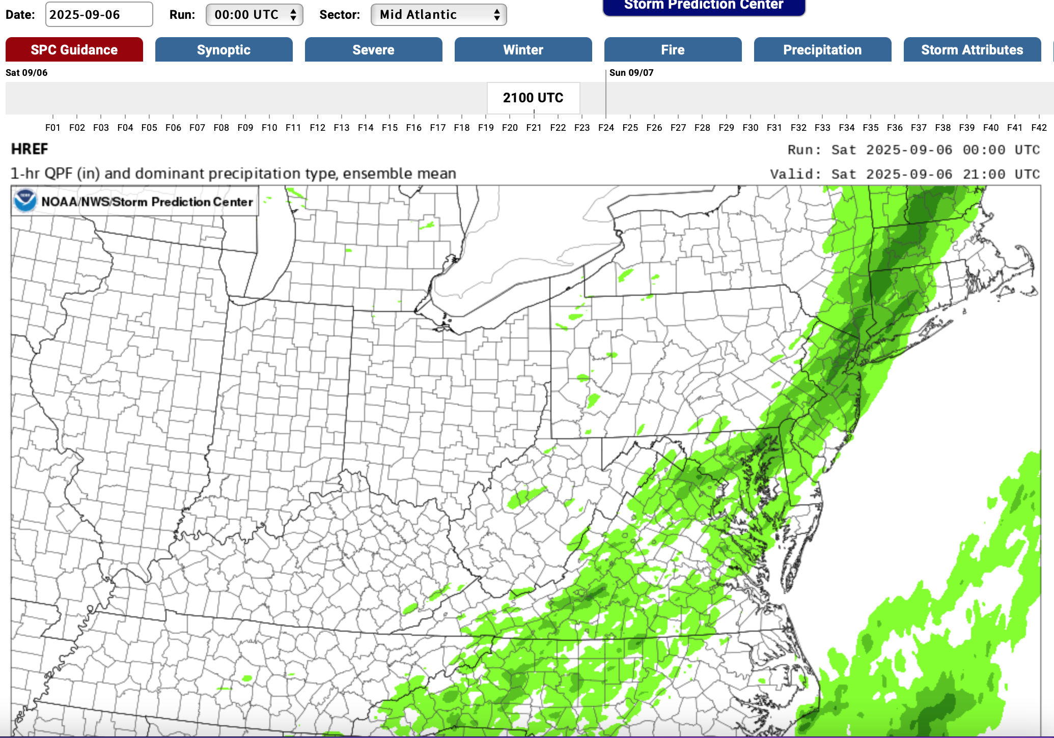
12z/16 RDPS - RGEM starts out much better than the NAM suite-RAP. So for me planning I80 north... some sort of cross between 12 HRRR/RGEM. Even SPC HREF from 00z/16 cycle sees too far s this morning and the max missed the 1" at Cape May as seen on the NJ CLIMAT web site. -
September 2025 OBS-Discussion centered NYC subforum
wdrag replied to wdrag's topic in New York City Metro
Good morning again... 1002A check of tropical tidbits for the 12z/16 NAM 12 and 3K vs reality and the 12z HRRR. 12z/16 NAM suite looks terrible to start... too far south by many many miles. Difficult to believe the initialization of qpf is so bad. EMC needs to check this. In the meantime the 12z HRRR looks like a much better start. Not saying anything about the outcome tomorrow, no different than above but for today... yikes. -
September 2025 OBS-Discussion centered NYC subforum
wdrag replied to wdrag's topic in New York City Metro
Of interest to me... the steadiest of all the modeling the past 5 days or so... the ECAI and its ECAIEPS. Rain is coming and underplayed I80 northward. I think NYC counts on 0.1-0.4" and up here in far nw NJ/ne PA/along the nYS border 0.05-0.30. WPC should have statistical comparisons of the ensembles and am surprised its so dry in its overnight forecast. Could be my interp is incorrect but while this wont be a great relief from the recent dryness, it will help, provided my interp is correct. Wont surprise me to see at least an inch in spots across theNJ/LI portion of our subforum. GEFS lagging and so we'll know tomorrow night and I guess that's what WPC tends to support. -
September 2025 OBS-Discussion centered NYC subforum
wdrag replied to wdrag's topic in New York City Metro
Late yesterday (9/13/25) shower amounts via CoCoRaHs Click if in disbelief.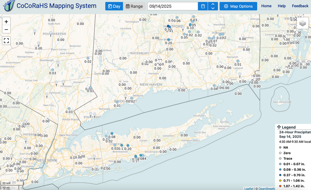
-
September 2025 OBS-Discussion centered NYC subforum
wdrag replied to wdrag's topic in New York City Metro
Thank you... may take as well as well as Bluewave. We've got so many classifications of things... we've lost simplicity of when to amp interest. Folks certainly cant keep up with all the changes... Farmers are interested for sure as this did seem to stunt corn in late summer. Otherwise, I view this summer as having been sort of dull... not much SVR and very limited tropical with heat dominating JJ first week of Aug. -
September 2025 OBS-Discussion centered NYC subforum
wdrag replied to wdrag's topic in New York City Metro
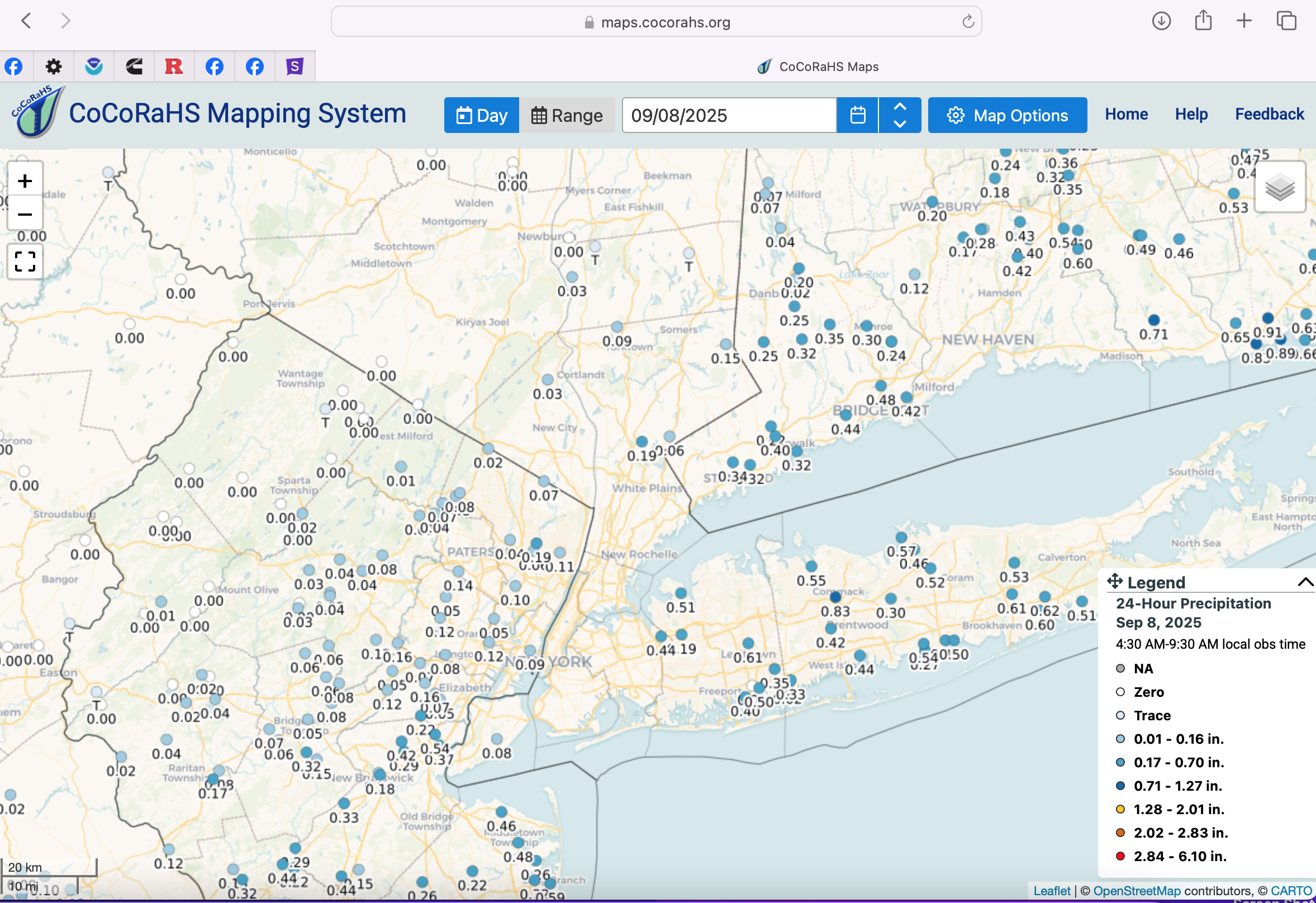
Just catching up: comments... modeling other than the dry CMCE, has patches of light-=mdt showers Saturday and Sunday. How it turns out I cant be sure but its repeatedly in guidance that I rely upon including EPS, SPC HREF and now some experimental MPAS guidance. Middle of next week northern fringe UA low rainfall potential to our NYC subforum. Drought monitor: I think we need perspective on the dryness... I just cant get overly concerned. Drought monitor needs a map to show the "perspective" - how unusual component of ST drought. NYC reservoir system less than 2% below normal as of yesterday. Yes vegetation takes a beating but almost every summer fall this happens... and here we are. The fall rainfall component I think is in part dependent on tropical connection. Obviously none so far and yet we got a pretty good dose a few days ago...even Wednesday morning (see CoCoRaHs attached) had some minor impact on sea behavior. As long as it doesn't get windy and hot... I think we're ok. attached the cocorahs for Wednesday morning,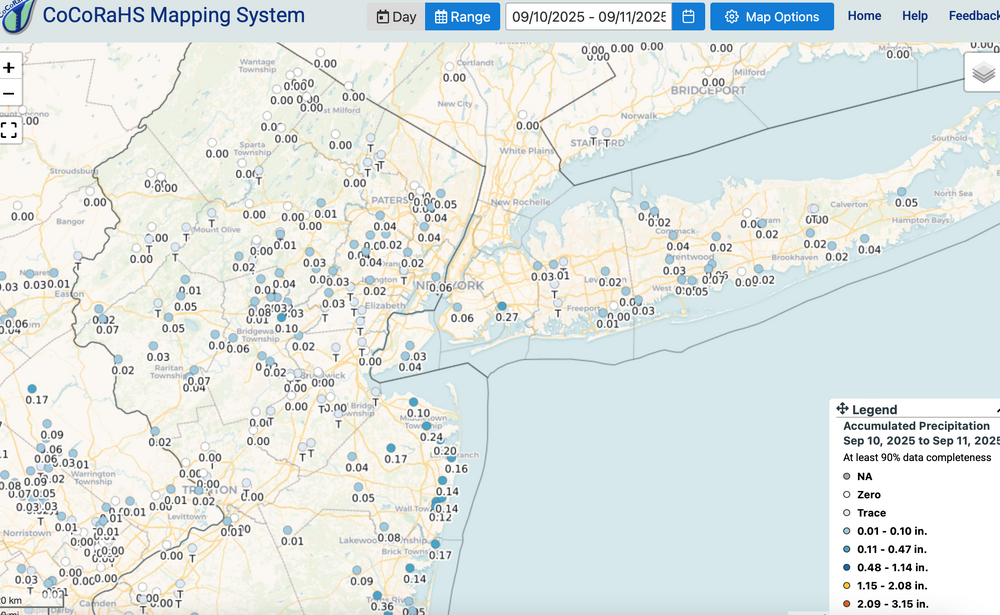
-
September 2025 OBS-Discussion centered NYC subforum
wdrag replied to wdrag's topic in New York City Metro
I agree with you but overall, the EC AI did not buy into the initial Sunday-Monday EC EPS closed low aloft scenario...admittedly as we mentioned... highly unusual pattern evolution. I am curious as to the multiple ensembles with sct showers Saturday (FOUS has LGA 90% RH at 60 hours 00z Sun) and it still looks like sct or widespread showers ahead of the seed moving short wave Sunday. Middle of next week might also have closed low feature in mid ATLC. For now will monitor what might transpire. -
September 2025 OBS-Discussion centered NYC subforum
wdrag replied to wdrag's topic in New York City Metro
Yes... and it was my mistake not checking EC AI... it never had this EPS/CMCE solution. Drier GEFS was right. Now warmer pattern and I suspect smokey eventually next week from Canada. -
September 2025 OBS-Discussion centered NYC subforum
wdrag replied to wdrag's topic in New York City Metro
I'll need to wait this out... one thing I didnt see was EC AI was almost nothing. It could be the EC suite (non AI) is too strong and too far southwest with the 5H vort plunging sdwd from south center Canada with the resultant sfc response too robust here. Would make this a period of waa showers Sunday afternoon and maybe cool frontal showers Monday. I do think its best to play temps conservatively and cooler in this pattern for another 10 days and wait this out a bit but I plan on showers Sunday afternoon and possibly right into Monday night. Patience... at least for me til a I reconsider later on. 12z WPC D4-6 guidance has boosted qpf a bit and I think that right... dont plunge into the unusual heavy solution till we have more confidence. Lets not say its a nice end to the weekend beginning of next week. -
September 2025 OBS-Discussion centered NYC subforum
wdrag replied to wdrag's topic in New York City Metro
smooth it for now... its raining today and that was relatively dismissed-underestimated by media communicators. VERY unusual pattern for Sun-Mon so not a lock 1.5"+ but am pretty sure many of us will see more rain than that which occurs today. -
September 2025 OBS-Discussion centered NYC subforum
wdrag replied to wdrag's topic in New York City Metro
So... I see very little mPing on the on going sprinkles to moderate showers occurring NJ/LI/NYC area... a little disappointing. I see .08 in 1 hr vicinity LGA in the last hr or two. Lets see how fast the clouds go away from the coasts... could be a day or two? How about the 16z Sunday-06z/Tuesday showery event... unusual pattern development but possible and ensembles agree, except the lightest GEFS which seems to be lagging. I'll side with the EPS/CMCE on this one and those who have plans late Sun or Mon ,may want to consider raincoats etc. -
September 2025 OBS-Discussion centered NYC subforum
wdrag replied to wdrag's topic in New York City Metro
Thank you... one thing I didnt see but the data may be inconsequential? Are the new sensors reading slightly cooler when side by side with the replaced 20 year old sensors? -
September 2025 OBS-Discussion centered NYC subforum
wdrag replied to wdrag's topic in New York City Metro
ASOS new temp sensors? I'm out of touch... LINK for info? Thanks, Walt -
September 2025 OBS-Discussion centered NYC subforum
wdrag replied to wdrag's topic in New York City Metro
Regarding LR: Complications for Wed-Fri, could result in some periodic rain for the coasts and at the least lots of clouds. Overall: I didnt check recent dryness, but already sw Canada seems to have been burning for a while and from what I can tell, excessive heat spreads eastward, north of the Great Lakes. My guess is lots of smokey sky in our future next week when the pattern at mid levels seems to encourage sewd drift of sw Canada smoke. That does not translate to near surface aerosol complications but visually, I 'think' we're headed to a return of smoky sky. -
September 2025 OBS-Discussion centered NYC subforum
wdrag replied to wdrag's topic in New York City Metro
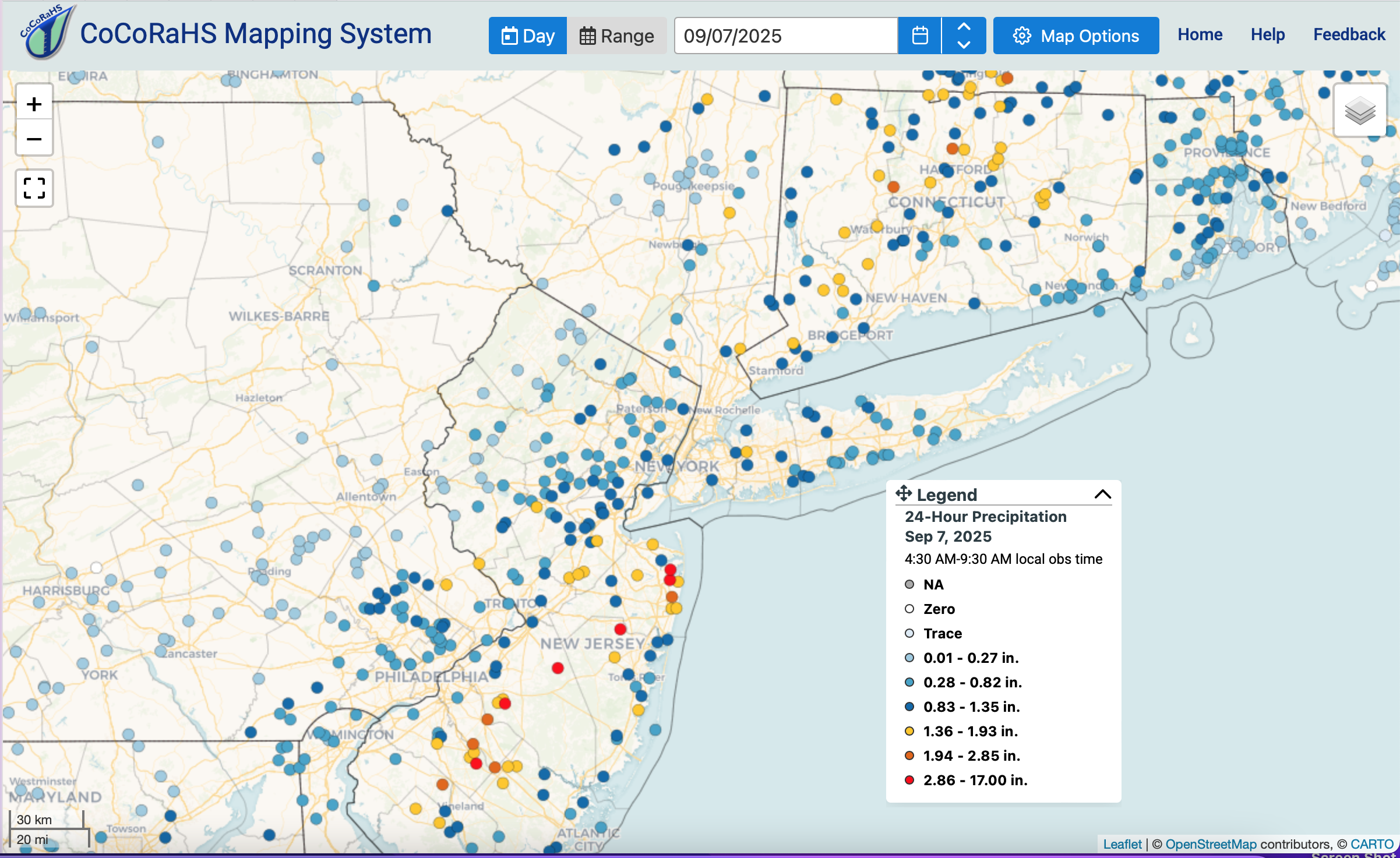
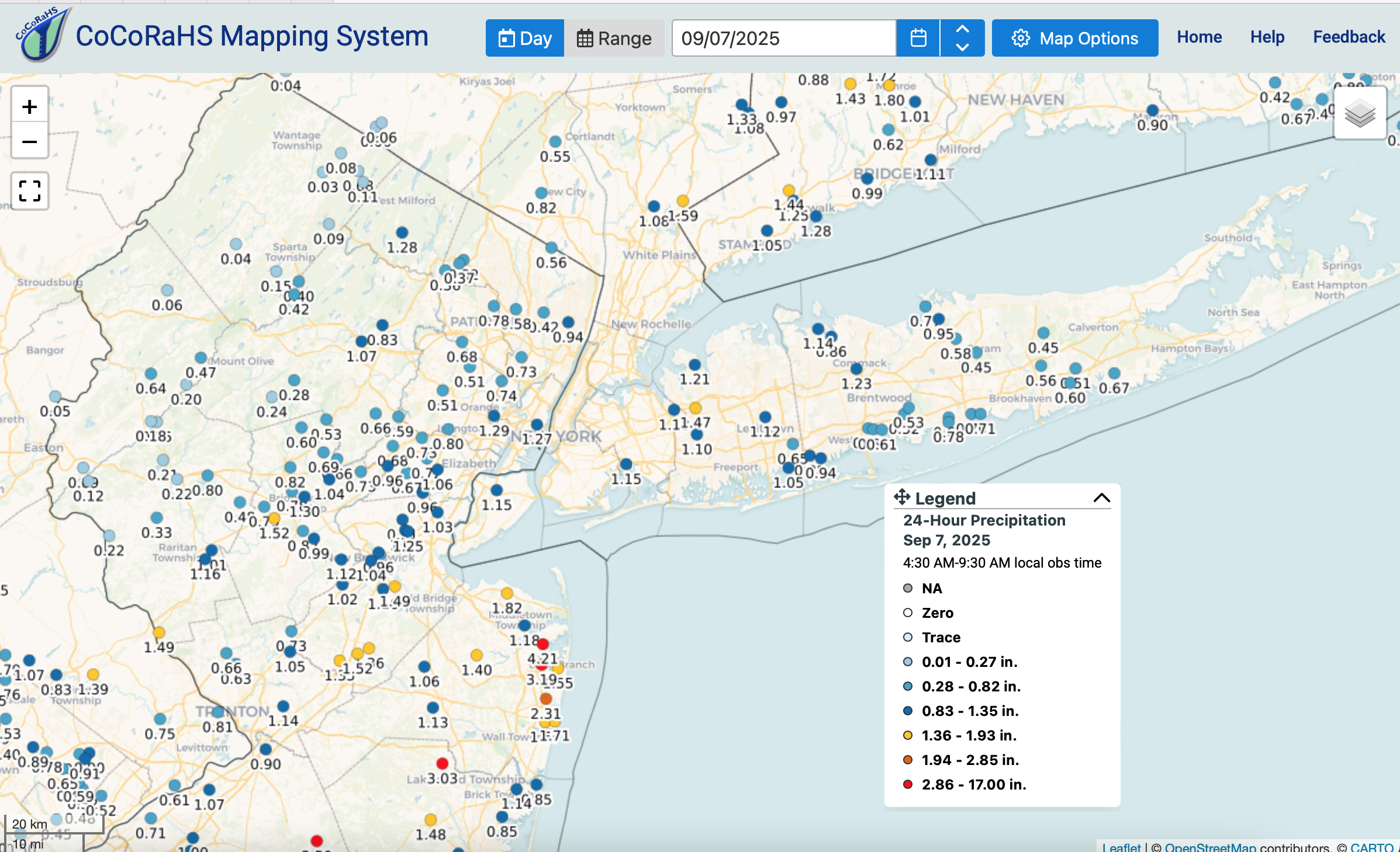
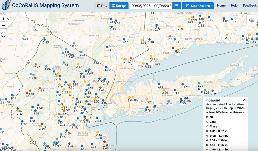
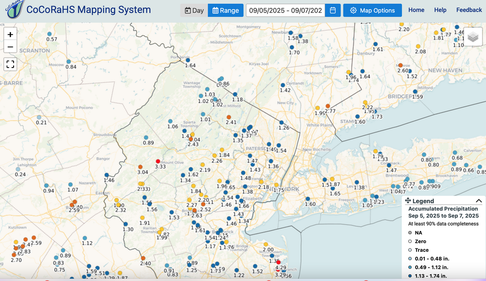
CoCoRaHs summary late Fri, late Sat-Sun events... should help lower drought classification by one, that we will see Thursday. Note the whole NYC subforum did very well... max axis near I95, give or take. E Li you did aok. Click for clarity the sunDAY leftovers, the Fri-Sun broad look (reds the heaviest), and then the detailed bulk NYC subforum.
-
September 2025 OBS-Discussion centered NYC subforum
wdrag replied to wdrag's topic in New York City Metro
I see nothing that excites a thread from me for our NYC subforum for the next week or two, maybe longer? Glad I didnt thread yesterday. Some severe and iso flooding NJ (4+ in Monmouth County per CoCoRaHs). Overall, the global model guidance defied drier stats, beginning from late August and the wetter global guidance broadly verified, max qpf axis always to be adjusted. You'll see the Fri-Sun combo results tomorrow. I am observing a dead Hurricane Season so far, and note also that I thought this was a quiet summer for severe here in our NYC subforum. Have a day, Walt -
September 2025 OBS-Discussion centered NYC subforum
wdrag replied to wdrag's topic in New York City Metro
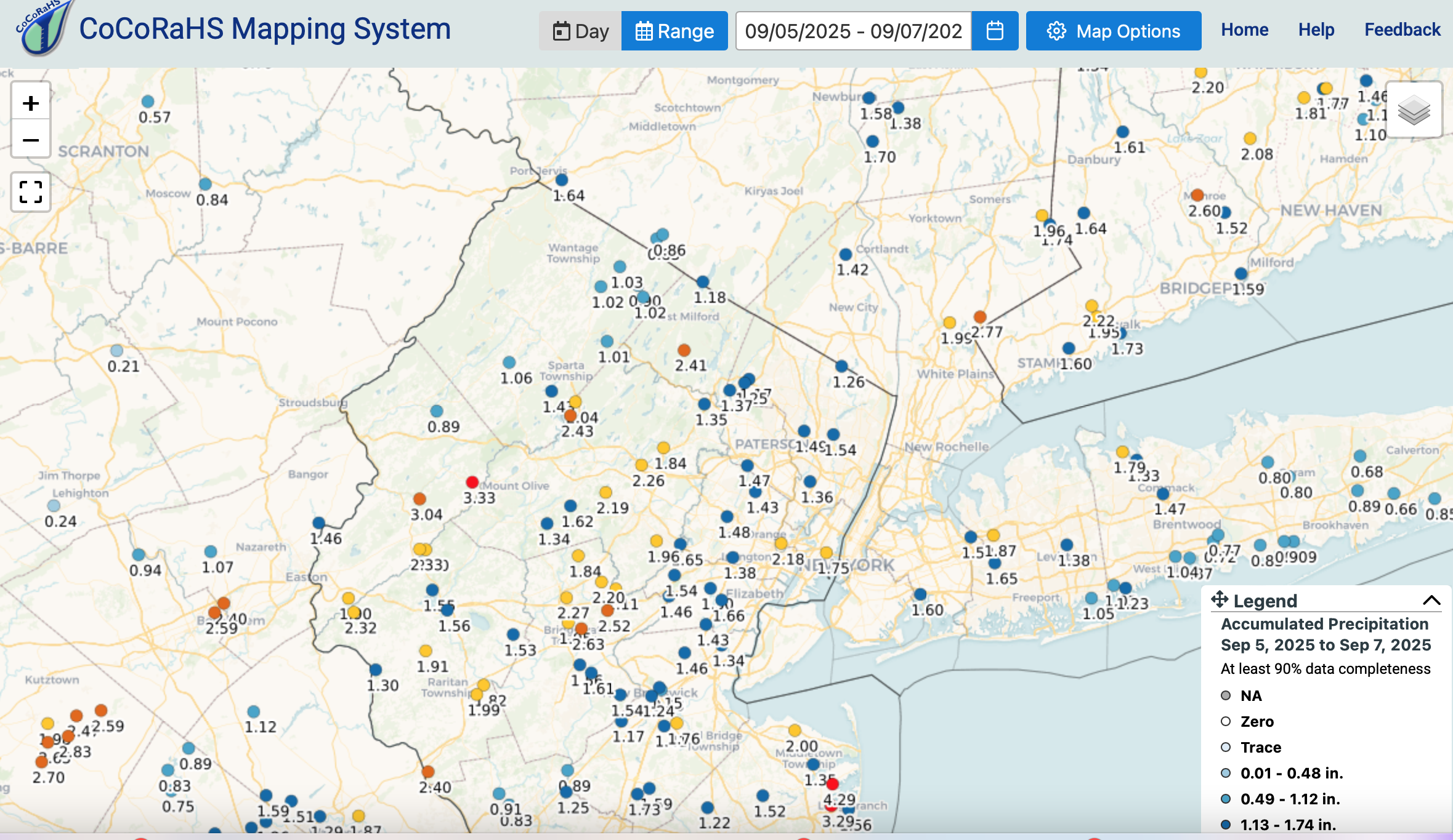
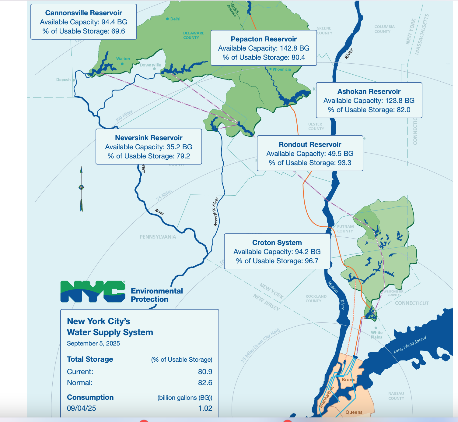
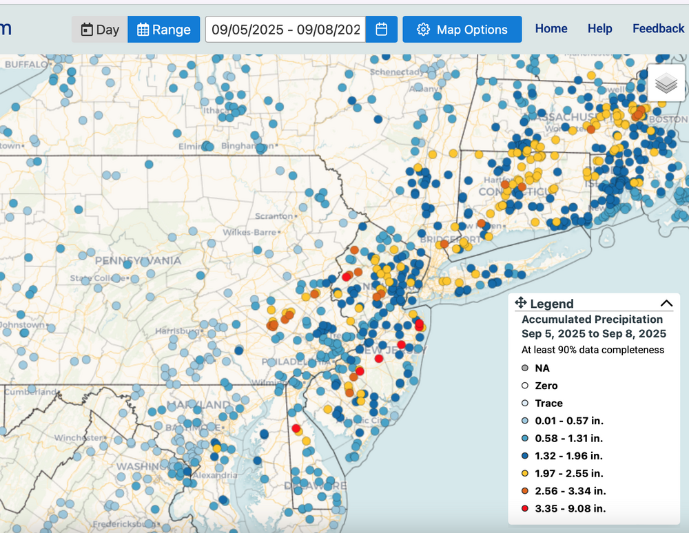
CoCoRaHs Regionally yesterday, Locally yesterday, Fri-Sun CoCoRaHs combo and the reservoirs (only through 9/5). I guess I'm not too alarmed... fall season is tropical related but less and less evapo-transporation as days grow shorter and climo temps lower. Click for clarity.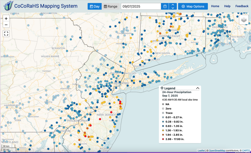


-
September 2025 OBS-Discussion centered NYC subforum
wdrag replied to wdrag's topic in New York City Metro
NYC CP about .65 in 30 minutes, ongoing -
September 2025 OBS-Discussion centered NYC subforum
wdrag replied to wdrag's topic in New York City Metro
Not threading. Follow NWS warnings-statements. Discussed plenty already. I85 corridor seems to be the central axis for a 1-3" total by Noon Sunday with isolated 4" and chc FFW or FLW in urban centers of ne NJ/NYC/w CT, and near small streams in NJ/CT. MAX 6" showing up SPCHREF in s NJ past 2 cycles but 4-4.5"possible somewhere in ne NJ sw CT. So maybe I'm too lax on this but I think you have this covered. SVR and FF threat mainly til 10PM, but expect some mdi-heavy rain tomorrow morning before it quits midday-afternoon. Will add CoCoRaHs 24 hour totals tomorrow and the two event summary on Monday morning. -
September 2025 OBS-Discussion centered NYC subforum
wdrag replied to wdrag's topic in New York City Metro
Thank you. 12z SPC HREF is saying it will happen up and down the I95 corridor. Bring your swimmies if you're outside and dry clothes for inside. 80% prob of watch issuance in latest convective outlook up and down I95. Will probably issue NOW-OBS thread 130PM if not sooner. This will be significant for some folks. -
September 2025 OBS-Discussion centered NYC subforum
wdrag replied to wdrag's topic in New York City Metro
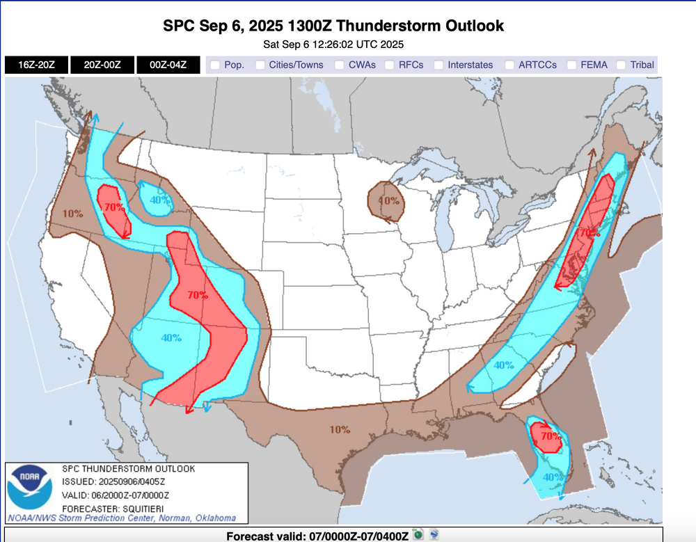
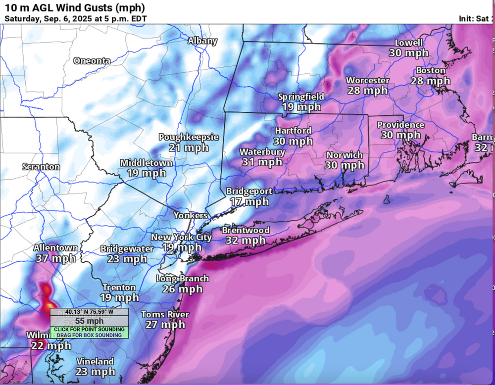
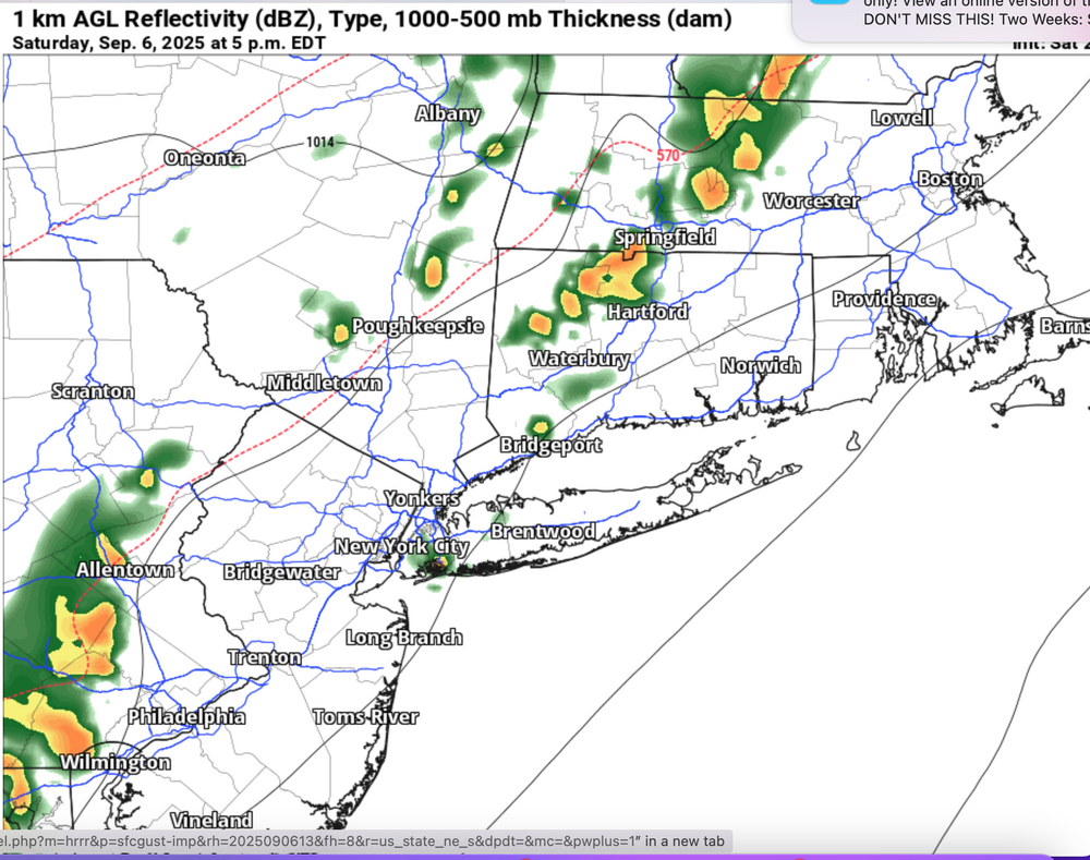
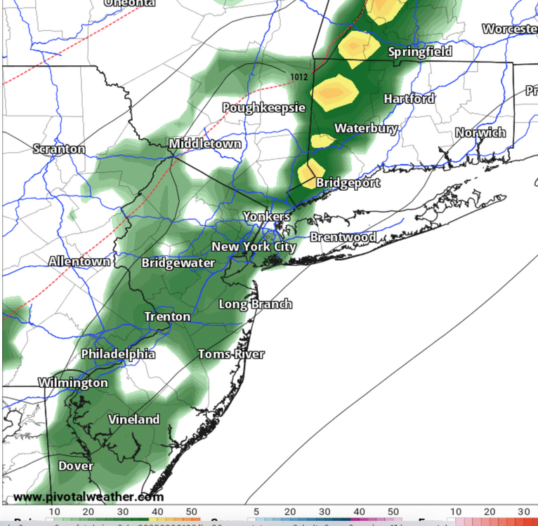
Regarding this afternoon I95 corridor: Not knowing when football games start etc... but be prepared for delays. Regarding Philly... your call as always. I would not risk outdoor celebration if it was me, except maybe the initial ceremony. NO guarantees as to what will happen but here is info from SPC and late arriving HRRR. Watch for convection NYC area developing 1230-2P, then the big squall line forming 2PM e PA and marching e from there. See graphics... cherry picked indeed but stuff I use to make decisions. I may still get a NOW thread going at 130PM. I do think there are going to be travel delays due to ponding on roads and 1-2.5" in spots by 8PM. PWAT pretty high... near 1.8". Graphics imply be alert... there will be variations. Consider downside risk outside your personal interest and thinking of impact on surroundings. Last night SPC HREF hourly for 5P. The SPC outlook prob for thunderstorms 4-8P (70% I95 corridor 13z HRRR gust graphic 5P (55 MPH se PA) 13z HRRR 5P reflectivity (might be too slow) 12z NAM 5P.
-
September 2025 OBS-Discussion centered NYC subforum
wdrag replied to wdrag's topic in New York City Metro
Alright... I'll post some info for all to digest in 3 min. -
September 2025 OBS-Discussion centered NYC subforum
wdrag replied to wdrag's topic in New York City Metro
?