weathermedic
-
Posts
2,276 -
Joined
-
Last visited
Content Type
Profiles
Blogs
Forums
American Weather
Media Demo
Store
Gallery
Everything posted by weathermedic
-

December 2020 General Discussions & Observations Thread
weathermedic replied to bluewave's topic in New York City Metro
Received .72 inches of rain with a max wind gust at 47 mph (at 3am) at my station in Sheepshead Bay. -
December 2020 General Discussions & Observations Thread
weathermedic replied to bluewave's topic in New York City Metro
From OKX AFD early AM discussion: A mid level shortwave trough may continue the chance of showers into Sunday night with perhaps a rain/snow mix across the interior. At this time looks as though the precipitation will end by late Sunday night as the disturbances moves to the northeast and north. Additionally, in response to Pac jet energy farther south, a couple of weak coastal lows Sunday night into Monday look to pass well south and east of the region. Eventually, a much deeper low forms east of New England Monday night into Tuesday. There is still some hint of Norlun trough/trowal in the vicinity of the northern Mid Atlantic at the same time, but the placement of these is always difficult this many days out. Thus, have maintained a low chance of precipitations at this time. -
The milk and bread madness is in full effect at the stores
-
December 2020 General Discussions & Observations Thread
weathermedic replied to bluewave's topic in New York City Metro
Dense fog advisories up for much of the area. -
December 2020 General Discussions & Observations Thread
weathermedic replied to bluewave's topic in New York City Metro
Freezing fog a possibility in rural areas tonight. From OKX AFD: Of particular concern is the potential for freezing fog tonight. As the high shifts offshore, low level moisture will increase, especially for western areas. With temperature dipping below freezing, freezing fog is possible (more likely for the outlying areas of non-metro northeast New Jersey and the Lower Hudson Valley). However, there is still a fair amount of uncertainty with the development of the fog, therefore, only went with patchy freezing fog. -
December 2020 General Discussions & Observations Thread
weathermedic replied to bluewave's topic in New York City Metro
Same here in southern Brooklyn -
Feb 78 still gets my vote. I was a kid but remember it well. The huge drifts that were everywhere was amazing. One side of the street had asphalt showing while the other was buried under drifts. Dec 2010 came close with the drifting.
-
Vendor, Blog and TV Channel Forecasts Thread Part 2
weathermedic replied to Rjay's topic in New York City Metro
DT released his winter forecast: -
Vendor, Blog and TV Channel Forecasts Thread Part 2
weathermedic replied to Rjay's topic in New York City Metro
Larry Cosgrove in his latest blog says most of US to be in pac zonal flow with periodic cold air intrusions between the Rockies and Appalachians at least through the 3rd week of December. -
Vendor, Blog and TV Channel Forecasts Thread Part 2
weathermedic replied to Rjay's topic in New York City Metro
He usually predicts something similar every year -
Vendor, Blog and TV Channel Forecasts Thread Part 2
weathermedic replied to Rjay's topic in New York City Metro
Here is another "early" winter weather forecast: https://www.weatherconcierge.com/the-weather-concierge-winter-forecast-of-2018-19/ -
Vendor, Blog and TV Channel Forecasts Thread Part 2
weathermedic replied to Rjay's topic in New York City Metro
Bernie Rayno says to follow the upper low (just north of it's track) for the snow. Will make its own cold air. Has the northern half of PA, southern NYS and northern half of NJ, NYC and western L.I. for a changeover to snow. -
Vendor, Blog and TV Channel Forecasts Thread Part 2
weathermedic replied to Rjay's topic in New York City Metro
...Or the once an hour (during the daytime hours-report was usually repeated for a couple of hours before it would be updated 2 or 3 times a day) for a live Accuweather report on 1010 WINS when Dr. Joe Sobel or Eliot Abrams or JB would come on the air. -
Vendor, Blog and TV Channel Forecasts Thread Part 2
weathermedic replied to Rjay's topic in New York City Metro
Bernie Rayno said upcoming pattern looks like the first couple of weeks in Feb will be cold and stormy in the east. Not too enthusiastic about Mon-Tue. Says that may give eastern New England a few inches of snow. He said pattern looks like it wants to form a storm and move it up along the eastern seaboard in the next week Friday time frame. We shall see. -
Vendor, Blog and TV Channel Forecasts Thread Part 2
weathermedic replied to Rjay's topic in New York City Metro
Jeff Smith from Channel 7 in NYC (AccuWeather outlet) just updated snowfall amounts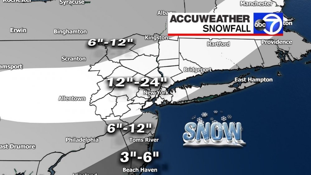
-
Vendor, Blog and TV Channel Forecasts Thread Part 2
weathermedic replied to Rjay's topic in New York City Metro
Bernie Rayno (used the word epic) heading in to work to make a video. Says no reason not to go with the 12z European. Also said to expect at least some mixing into I-95. "Tremendous" snow just west of 95 -
Vendor, Blog and TV Channel Forecasts Thread Part 2
weathermedic replied to Rjay's topic in New York City Metro
Well Bernie Rayno just tweeted he thinks there will be some mixing up to I-95 with the storm. Maybe he (and AccuWeather) are factoring that in to accumulations? -
Vendor, Blog and TV Channel Forecasts Thread Part 2
weathermedic replied to Rjay's topic in New York City Metro
Bernie posted on Twitter a short while ago the GFS 12Z 500mb map is slowly coming around to the Euro showing a stronger storm for Sat-Sun. He will have a new video coming out after 2pm. -
Vendor, Blog and TV Channel Forecasts Thread Part 2
weathermedic replied to Rjay's topic in New York City Metro
Nick Gregory's (from FOX-5 NYC) winter forecast http://www.fox5ny.com/weather/214931324-story?utm_source=twitterfeed&utm_medium=twitter