weathermedic
-
Posts
2,223 -
Joined
-
Last visited
Content Type
Profiles
Blogs
Forums
American Weather
Media Demo
Store
Gallery
Everything posted by weathermedic
-
 Sun already disappeared (at least for now) behind the clouds here in lower Manhattan. Hopefully temps won't rise too much from the morning lows.
- 3,762 replies
-
- 3
-

-
- heavy snow
- heavy rain
- (and 3 more)
-
Saw tidal flooding this morning along Brookville Blvd in Queens. Was about a foot of water on the roadway with the lunar high tide. Can imagine that would be impassable if the storm does what it’s supposed to do.
-
The milk and bread madness is in full effect at the stores
-
Flakes starting to mix in on 5th Av and E 62 St in Manhattan
-
Latest OKX AFD: && .LONG TERM /TUESDAY THROUGH SUNDAY/... NWP guidance in very good agreement on evolution of synoptic scale ingredients for what should be a major winter storm from Wednesday afternoon into Thursday. A blocking upper high over Greenland will force an extension of the polar vortex to pass to its south and cut off E of the Canadian Maritimes, with confluence to its rear maintaining strong/cold high pressure from Ontario/Quebec into New England from Tue into Wed. Meanwhile, energy just about to move onto the West Coast will dig SE toward the srn Plains where it may cut off briefly, but should maintain a positive to neutral tilt aloft as it moves E of the Mississippi valley on Wed, lessening the chance for warm air to intrude aloft. Primary sfc low pressure should weaken to the W of the Appalachians on Wed while a secondary low forms right along the Carolina coast and then intensifies as it moves to a position off the Delmarva coast late Wed night. Given the supply of low level cold air and unlikelihood of warmer air intruding aloft, this event looks to be all snow for just about the entire region, except maybe the south shore of eastern Long Island for a time. Too early to get into the mesoscale details here, but confidence in significant snowfall amounts over 6 inches continues to increase, with potential for over a foot of snow in areas that experience the best mesoscale lift and snow growth NW of the low track. NE winds should also be quite strong along the coast due to the pressure gradient between the strong high to the north and the developing low, as high as 25-35 mph with gusts up to to 45 mph, causing considerable blowing and drifting of snow and at least near blizzard conditions. Still some question how quickly the low will pull out on Thu, with the ECMWF lagging a little behind the GFS, so steady snow still likely in the morning, then gradually tapering off from W to E through the day.
- 3,762 replies
-
- 1
-
-
- heavy snow
- heavy rain
- (and 3 more)
-
December 2020 General Discussions & Observations Thread
weathermedic replied to bluewave's topic in New York City Metro
Dense fog advisories up for much of the area. -
10:1 ratios (if that occurs) means that’s 3.3 inches liquid. I would cut those accumulations at least in half or even a little more.
-
December 2020 General Discussions & Observations Thread
weathermedic replied to bluewave's topic in New York City Metro
Freezing fog a possibility in rural areas tonight. From OKX AFD: Of particular concern is the potential for freezing fog tonight. As the high shifts offshore, low level moisture will increase, especially for western areas. With temperature dipping below freezing, freezing fog is possible (more likely for the outlying areas of non-metro northeast New Jersey and the Lower Hudson Valley). However, there is still a fair amount of uncertainty with the development of the fog, therefore, only went with patchy freezing fog. -
December 2020 General Discussions & Observations Thread
weathermedic replied to bluewave's topic in New York City Metro
Same here in southern Brooklyn -
1.02 inches of rain here at my station in Sheepshead Bay.
- 373 replies
-
- 1
-
-
- heavy rain
- wind event
- (and 2 more)
-
1.60 so far at my station in Sheepshead Bay.
-
Tornado watch for southern NJ
-
November 2020 General Discussions & Observations Thread
weathermedic replied to Rtd208's topic in New York City Metro
.42 here -
remnants of zeta and potential first flakes for some areas
weathermedic replied to forkyfork's topic in New York City Metro
Mostly sleet now here in Bellport Suffolk County. Car thermometer showing 38 degrees. -
remnants of zeta and potential first flakes for some areas
weathermedic replied to forkyfork's topic in New York City Metro
A few mangled flakes mixing in with the rain on the windshield. On the Southern State Parkway at the Meadowbrook Pky. Edit: sleet as well. -
Feb 78 still gets my vote. I was a kid but remember it well. The huge drifts that were everywhere was amazing. One side of the street had asphalt showing while the other was buried under drifts. Dec 2010 came close with the drifting.
-
Vendor, Blog and TV Channel Forecasts Thread Part 2
weathermedic replied to Rjay's topic in New York City Metro
DT released his winter forecast: -
Vendor, Blog and TV Channel Forecasts Thread Part 2
weathermedic replied to Rjay's topic in New York City Metro
Larry Cosgrove in his latest blog says most of US to be in pac zonal flow with periodic cold air intrusions between the Rockies and Appalachians at least through the 3rd week of December. -
Vendor, Blog and TV Channel Forecasts Thread Part 2
weathermedic replied to Rjay's topic in New York City Metro
He usually predicts something similar every year -
Vendor, Blog and TV Channel Forecasts Thread Part 2
weathermedic replied to Rjay's topic in New York City Metro
Here is another "early" winter weather forecast: https://www.weatherconcierge.com/the-weather-concierge-winter-forecast-of-2018-19/ -
Vendor, Blog and TV Channel Forecasts Thread Part 2
weathermedic replied to Rjay's topic in New York City Metro
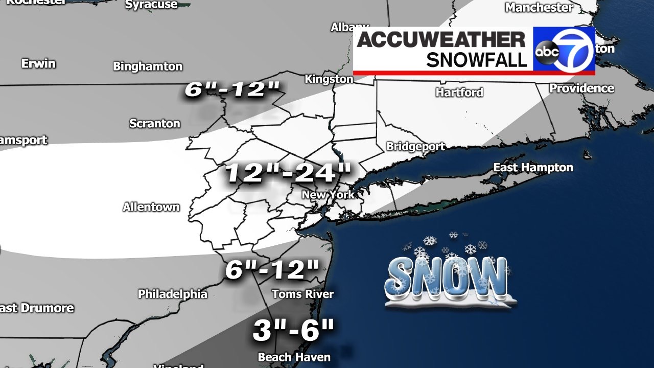
Bernie Rayno says to follow the upper low (just north of it's track) for the snow. Will make its own cold air. Has the northern half of PA, southern NYS and northern half of NJ, NYC and western L.I. for a changeover to snow. -
Vendor, Blog and TV Channel Forecasts Thread Part 2
weathermedic replied to Rjay's topic in New York City Metro
...Or the once an hour (during the daytime hours-report was usually repeated for a couple of hours before it would be updated 2 or 3 times a day) for a live Accuweather report on 1010 WINS when Dr. Joe Sobel or Eliot Abrams or JB would come on the air. -
Vendor, Blog and TV Channel Forecasts Thread Part 2
weathermedic replied to Rjay's topic in New York City Metro
Bernie Rayno said upcoming pattern looks like the first couple of weeks in Feb will be cold and stormy in the east. Not too enthusiastic about Mon-Tue. Says that may give eastern New England a few inches of snow. He said pattern looks like it wants to form a storm and move it up along the eastern seaboard in the next week Friday time frame. We shall see. -
Vendor, Blog and TV Channel Forecasts Thread Part 2
weathermedic replied to Rjay's topic in New York City Metro
Jeff Smith from Channel 7 in NYC (AccuWeather outlet) just updated snowfall amounts