CNY_WX
-
Posts
2,717 -
Joined
-
Last visited
Content Type
Profiles
Blogs
Forums
American Weather
Media Demo
Store
Gallery
Everything posted by CNY_WX
-
KBGM should be in the middle of the heavier returns and their visibility is only 1/2 mile KBGM 200353Z 11011KT 1/2SM SN FZFG VV007 M04/M06 A2972 RMK AO2 SLP087 P0005 T10441056
-
It will be interesting to see the final ratios.
-
I believe it’s a Robert Trent Jones designed course. It is one of the most beautiful campuses in the country.
-
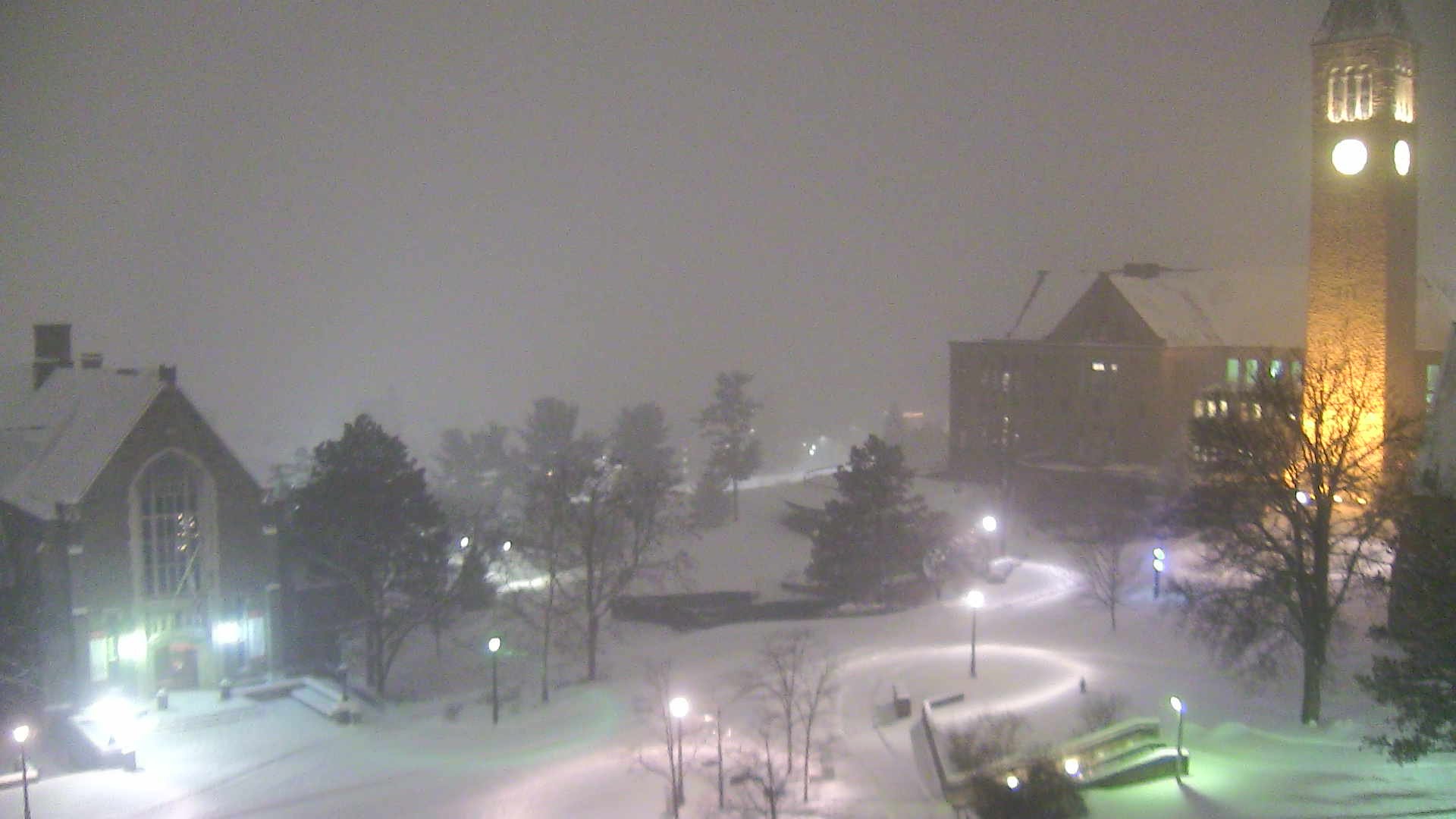
Looks like it’s snowing nicely on the Cornell campus.

-
Coming down pretty good but what is it with this crappy flake size? If you put 10 of these flakes together you might make a decent dendrite!
-
I hope so. There’s definitely a lot of moisture to our south.
-
Here are the last 12 hours of metars from CYHM. I don’t see anything to indicate snowfall rates to support 21 inches. CYHM 200100Z 03021G27KT 3/4SM R12/2800V4500FT/N -SN BLSN VV009 M14/M16 A2992 RMK SN8 SLP153 CYHM 200035Z 03018G25KT 3/4SM R12/3500FT/N -SN BLSN VV008 M14/M15 A2992 RMK SN8 SLP152 CYHM 200000Z 04021G26KT 5/8SM R12/5500FT/U -SN BLSN VV006 M13/M14 A2993 RMK SN8 SLP155 CYHM 192300Z 03018G24KT 5/8SM R12/5500FT/N -SN BLSN VV005 M13/M14 A2997 RMK SN8 /S04/ SLP168 CYHM 192250Z 04018KT 5/8SM R12/5000VP6000FT/U -SN BLSN VV006 M13/M14 A2997 RMK SN8 SLP169 CYHM 192200Z 03020KT 1/4SM R12/4500FT/N -SN BLSN VV006 M13/M14 A2999 RMK SN8 SLP174 CYHM 192100Z 03020KT 1/4SM R12/3500FT/N -SN BLSN VV006 M12/M14 A3002 RMK SN8 /S03/ SLP183 CYHM 192046Z 04020G25KT 1/4SM R12/2800FT/N -SN BLSN VV005 M12/M14 A3002 RMK SN8 SLP184 CYHM 192036Z 03021KT 1/8SM R12/3000FT/N SN BLSN VV005 M12/M14 A3003 RMK SN8 SLP187 CYHM 192014Z 03020KT 3/8SM R12/2800FT/N -SN BLSN VV005 M12/M14 A3003 RMK SN8 SLP189 CYHM 192000Z 03019G24KT 3/8SM R12/3500FT/N -SN BLSN VV008 M12/M13 A3004 RMK SN8 /S02/ SLP192 CYHM 191945Z 03019KT 3/8SM R12/3000FT/N -SN BLSN VV007 M12/M13 A3005 RMK SN8 SLP193 CYHM 191900Z 03015KT 3/8SM R12/2800FT/N -SN BLSN OVC005 M11/M12 A3008 RMK SN6SF2 SLP202 CYHM 191853Z 03014G20KT 3/8SM R12/3000FT/N -SN BLSN OVC006 M11/M12 A3009 RMK SN6SF2 SLP205 CYHM 191800Z 06019G25KT 3/4SM R12/4000FT/D -SN BLSN OVC010 M09/M11 A3010 RMK SN6SF2 /S05/ SLP209 CYHM 191732Z 07019G27KT 5/8SM R12/3000V4500FT/U -SN BLSN VV014 M09/M11 A3012 RMK SN8 SLP216 CYHM 191700Z CCA 07015G22KT 1/4SM R12/2400FT/N -SN BLSN VV005 M09/M10 A3014 RMK SN8 /S03/ SLP224 CYHM 191600Z CCA 05021G27KT 5/8SM R12/2600FT/N -SN DRSN VV006 M09/M10 A3017 RMK SN8 /S02/ PRESFR SLP233 CYHM 191548Z 05016G24KT 1/4SM R12/2800FT/N SN VV007 M09/M10 A3018 RMK SN8 SLP236 CYHM 191500Z 04013KT 1/2SM R12/3500FT/N SN VV006 M11/M13 A3020 RMK SN8 SLP243 CYHM 191434Z 04015KT 5/8SM R12/5000FT/U -SN OVC008 M12/M14 A3020 RMK SN6SC2 SLP245 CYHM 191400Z 03016KT 3/4SM R12/P6000FT/D -SN OVC018 M12/M14 A3020 RMK SN6SC2 SLP245
-
Are you sure that’s not 21cm?
-
You really think so? I hope you’re right.
-
I’ll take the under on that!
-
Just measured 1.7 inches. Snow has been steady but light all afternoon. Radar looks promising but waiting for the intensity to pick up.
-
Flake size is increasing as the heavier returns move over me.
-
4pm Update - 19 January Major winter storm impacting our area this evening through the rest of the weekend. For more information, please see our latest briefing at: https://go.usa.gov/xEZ3Q What has changed: temperatures have trended warmer, resulting in more mixed precipitation for NE PA and the Southern Tier of NY with reduced snow amounts in those areas compared to earlier forecasts. For full forecast information specific to your location go to weather.gov/bgm or mobile.weather.gov and enter your zip code in the textbox and hit go.
-
Looks like there’s some heavier returns over the southern tier heading towards CNY. Been snowing steadily all afternoon but flake size has been on the small size.
-
Snow has started here.
-
Latest from WSYR Channel 9: Updated: Jan 19, 2019 10:43 AM EST SYRACUSE (WSYR) - LATEST: As of 8:30 a.m. Saturday...Snow storm tracking a little farther north and bringing light snow in especially for Finger Lakes areas Saturday morning. Growing confidence for close to 2 foot totals for Syracuse and points south and east by Sunday afternoon THE TIMELINE: • Light snow begins Saturday morning for areas west of Syracuse • Onset of steadier snow begins around 2-3 p.m. Saturday • Heavy snow begins 7-9 p.m. Saturday • Heavy snow tapers by noon Sunday • Wind picks before daybreak Sunday and continues into Monday. • Arctic air settles in, dangerously cold wind chills Sunday night and Monday for all SPECIFICS: Snow becomes steady through the afternoon and evening on Saturday, we're thinking about 1-3" of accumulation by 8pm Saturday. The snow intensity picks up Saturday night and continues to fall heavily through Sunday morning. During this period of heavy snow, an additional 10-18" of snow could fall. Snow totals for the majority of CNY will be in the 1-2 foot range by the time this storm pulls off the east coast Sunday night. Areas farthest north, including Watertown will see slightly smaller amounts, closer to 5-10". We're not done with active weather though. To add insult to injury, gusty northwest winds will develop Sunday afternoon and continue Monday. With lots of fresh fluffy snow on the ground, winds gusting 20-30+ mph, will cause the snow to drift and reduce visibility. The wind will also bring dangerously cold wind chills, especially on Monday. Highs Monday are in the single digits but with the wind it'll feel more like 20 to 15 degrees below zero.
-
Still dry here, virga storm overhead.
-
Buffalo 9 Rochester 15 Syracuse 14 Albany 17 Ithaca. 18 Binghamton 20
-
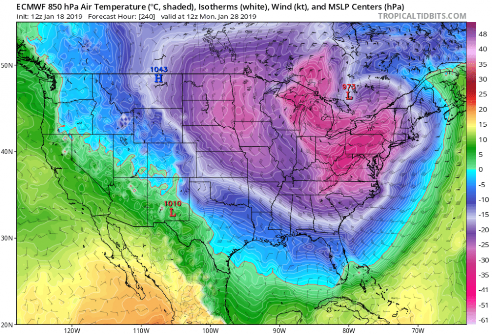
-30 - -35C air passing over the lakes. If this was to verify you know all you’ll hear is Polar Vortex....
-
There’s a chance, albeit small, that they might have to deflate the dome to prevent it from being damaged by the heavy snow load. That hasn’t happened in a while.
-
Might be an all nighter for some of us tomorrow night.
-
The NAM got NAMed!
-
We used to take food trays from Willard Straight and slide down Libe Slope. I think they banned that when a student got seriously hurt running into a tree. Good thing we have no admins because I’m getting way off topic.
-
It figures you finally might get enough snow to cancel classes and there’s no classes. Happy Birthday, btw. Hope you don’t have to drive up Buffalo St.!
-
If 2 feet verifies I wonder if Cornell will cancel classes Monday. They very rarely cancel classes.