CNY_WX
-
Posts
2,717 -
Joined
-
Last visited
Content Type
Profiles
Blogs
Forums
American Weather
Media Demo
Store
Gallery
Everything posted by CNY_WX
-
Why post this without explaining?
-
Montague radar is down.
-
I measured 0.63 inch LE from yesterday morning to this morning. When all’s said and done we’ll probably be around an inch for this event.
-
Not accumulating on dark surfaces here.
-
It looks like a snow globe outside. Nice parachutes falling
-
That area of heavier returns is heading right for me. Unfortunately, the temperature is above freezing so it will have difficulty accumulating. That area of heavier returns returns is heading right towards me. Unfortunately, temperatures are above freezing so the snow will have a difficult time accumulating
-
After being stuck at 32 all night it just went up to 33. As we get closer to midday we may start having accumulation issues.
-
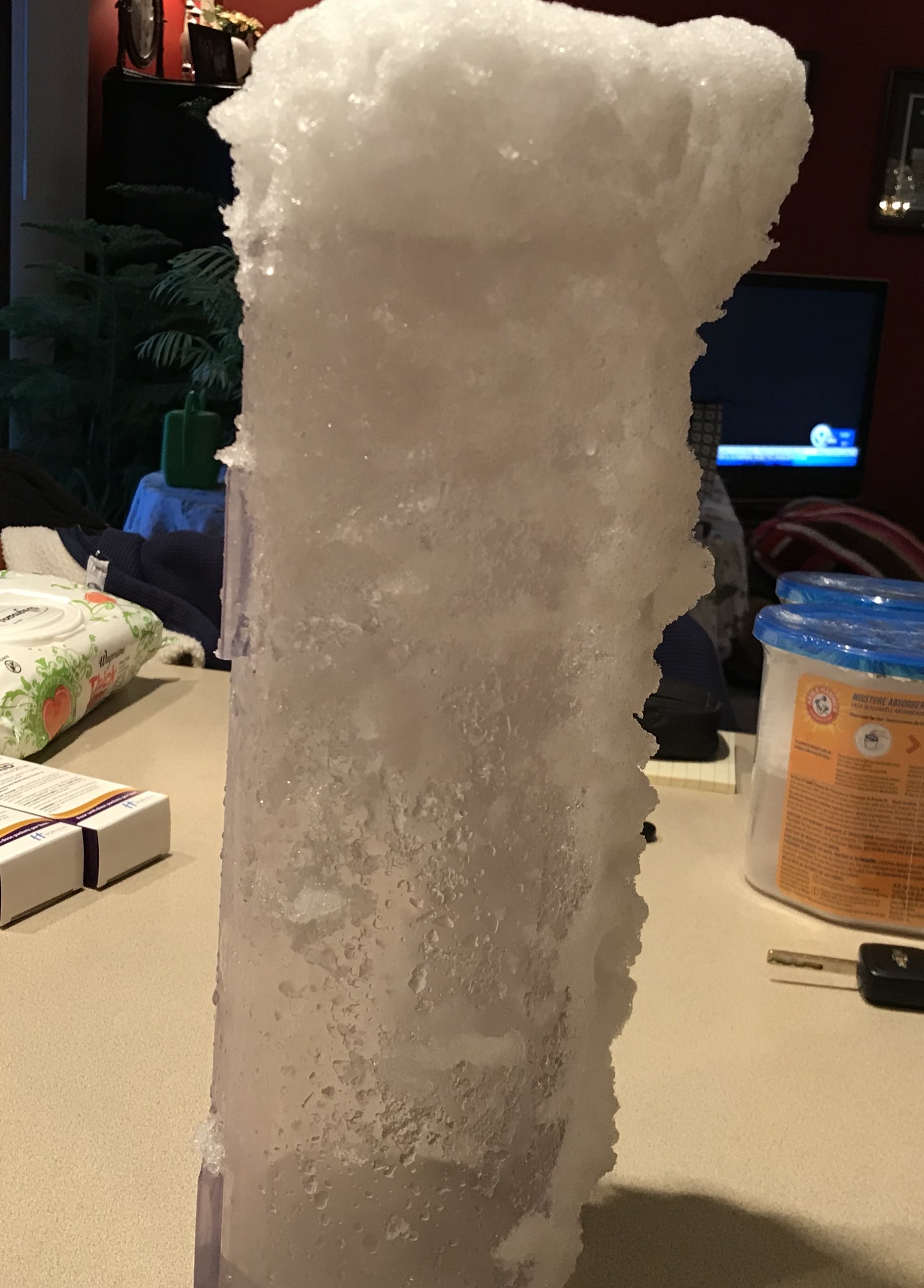
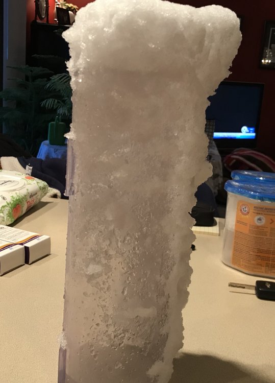
I just measured 4.6 inches. I don’t know how accurate my LE will be because the snow just pileup on the opening to the cylinder. I’m going to let the snow melt as is and what goes in the tube will be counted and what falls outside won’t.
-
After changing to rain during the mid day the precipitation has gone back to snow and it’s starting to accumulate. Temperature is back down to 33 and I see no problem getting to freezing once the sun sets. If it snows at this rate overnight we should have several inches by morning.
-
Back to rain here, 35 degrees.
-
NYZ017-018-036-037-044-281600- /O.UPG.KBGM.WW.Y.0032.181127T2000Z-181128T2300Z/ /O.NEW.KBGM.WS.W.0009.181127T1559Z-181129T0000Z/ Southern Cayuga-Onondaga-Madison-Southern Oneida-Cortland- Including the cities of Auburn, Syracuse, Hamilton, Oneida, Rome, Utica, and Cortland 1059 AM EST Tue Nov 27 2018 ...WINTER STORM WARNING IN EFFECT UNTIL 7 PM EST WEDNESDAY... * WHAT...Heavy snow. Additional snow accumulations of 3 to 6 inches in the valleys and 6 to 12 inches in the higher elevations. Winds gusting as high as 30 mph. * WHERE...Southern Cayuga, Onondaga, Madison, Southern Oneida and Cortland Counties. * WHEN...Snow will continue through the afternoon with heavier snow expected tonight and Wednesday morning. Snow intensities will be less than 1 inch per hour during the afternoon with between 1 and 2 inches per hour tonight and Wednesday morning. Snow will taper in intensity Wednesday afternoon. * ADDITIONAL DETAILS...Travel could be very difficult to impossible mainly over the higher terrain areas. Areas of blowing snow could significantly reduce visibility. The hazardous conditions could impact the morning or evening commute. Interstate 81 between Syracuse and Marathon could become very dangerous especially over the higher terrain.
-
I’m teetering right on the edge. That snow is about as wet as it can get and still be called snow.
-
Snow has picked up here and flake size has increased. Temperature is 34 so I doubt it is accumulating very efficiently.
-
Cooperstown will be a zoo on Hall of Fame weekend next year when Mariano Rivera gets inducted. It’ll be even worse when Jeter gets in.
-
It’s snowing here but lightly. Temperature is up to 34 so anything that falls is slush. Hopefully tonight conditions will improve for accumulations. I would be happy if we could reach 6 inches out of this.
-
Radar depiction of where it’s rain vs snow
-
Channel 9’s radar shows the rain/snow line just west of I81.
-
White rain falling here, about 3/8 inch of cement on my car. 1.21 in of liquid in 24 hours.
-
Ok, lock it in!
-
You should learn a lot about the fickleness of lake effect snow this winter where the difference of a few degrees in wind direction will leave some smiling and some crying, lol.
-
So you get to vote on it? From what I’ve read it sounded like a done deal.
-
Hey BuffaloWeather, are you near the water tower in Hamburg that is going to be painted to look like a hamburger? https://www.wivb.com/news/local-news/hamburg-water-tower-to-get-mouth-watering-redesign/1616608537
-
If the Euro verifies we’ll be wearing shorts, lol.
-
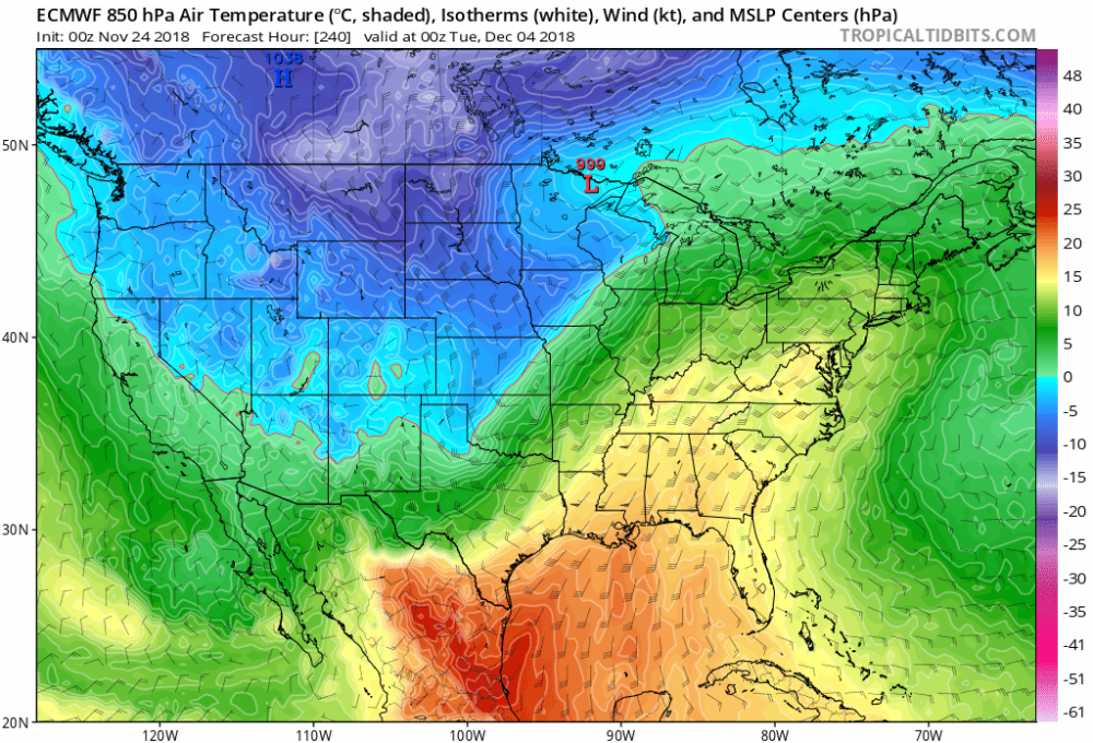
That’s ahead of a big storm that cuts through the western lakes. Looks to be warm and wet here. Parts of the high plains and Minnesota could see a blizzard.
-
My thermometer just hit the big goose egg.