CNY_WX
-
Posts
2,717 -
Joined
-
Last visited
Content Type
Profiles
Blogs
Forums
American Weather
Media Demo
Store
Gallery
Everything posted by CNY_WX
-
As a N.Y. Ranger fan I have to pipe in. The Rangers are hot, 9-1-1 in their last 11 games. They are now tied for first in the Metropolitan division. 19 year old Filip Chytil scored a goal in his 5th straight game as the Rangers beat the Islanders 5-0 last night.
-
it doesn’t look like much on radar, very low topped in the frigid air. I’m sitting at 12 degrees.
-
Happy Thanksgiving to everyone! I woke up to a steady fall of fluffy dendrites. This would be a perfect Christmas morning.
-
The sun is out here, too but the temperature keeps dropping. Down to 26.
-
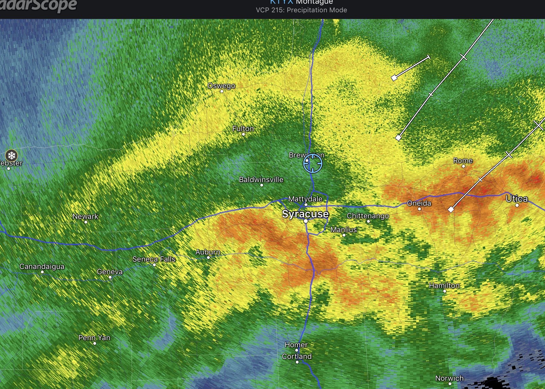
Streamer off Georgian Bay is feeding a developing band over Lake Ontario.
-
Wind has picked up and another burst of snow coming through. It’s nasty out there!
-
Pouring snow now.
-
We’re about to get into it! Snow is picking up here.
-
Line is not as intense.
-
As predicted, the squall line has fallen off the lake and weakening has commenced. It’s over Parish right now, about 13 miles north of me, and it will probably be just flurries when it reaches Brewerton.
-
SNOW SQUALL WARNING NWS BINGHAMTON NY 954 AM EST WED NOV 21 2018 NYC053-065-067-211611- /O.NEW.KBGM.SQ.W.0007.181121T1454Z-181121T1600Z/ 954 AM EST WED NOV 21 2018 Madison County-Oneida County-Onondaga County- The National Weather Service in Binghamton has issued a * Snow Squall Warning for... Central Oneida County in central New York... Northwestern Madison County in central New York... Northeastern Onondaga County in central New York... * Until 1100 AM EST. * At 954 AM EST, a dangerous snow squall was located along a line extending from Fulton to near Lowville, moving southeast at 25 mph. HAZARD...Whiteout conditions. Zero visibility in heavy snow and blowing snow. Wind gusts greater than 30 mph. A quick inch or so of snow could fall in less than 30 minutes. A brief rumble can not be ruled out as well. SOURCE...Radar and webcams. IMPACT...Dangerous life-threatening travel. Locations impacted include... Clay, Rome, Cicero, Oneida, North Syracuse, Lee, Vienna, Minoa, Phoenix and Camden. This includes the following highway exits... Interstate 90 near 34A. New York Interstate 81 between 28 and 31.
-
That’s up in Wolfie territory and moving towards me.
-
I agree with DeltaT13. Normal highs for this date is 46 at KSYR. How many Thanksgivings recently have had temperatures above normal and no snow going into December. I’m at 18 inches already this season. The snow is picking up in intensity as the arctic front approaches. The squall line off the lake is getting stronger but will probably weaken as it moves south and loses it’s lake connection.
-
Channel 9’s timecast has a squall line moving through the Syracuse metro area between 7 and 8 AM ahead of the arctic front followed by multi bands through the day into the evening on a NW flow. They’re keeping the accumulations down with 3-5 over the Tug and only 1-3 elsewhere.
-
URGENT - WINTER WEATHER MESSAGE National Weather Service Binghamton NY 232 PM EST Tue Nov 20 2018 NYZ018-036-037-211945- /O.NEW.KBGM.WW.Y.0030.181121T1200Z-181122T0300Z/ Onondaga-Madison-Southern Oneida- Including the cities of Syracuse, Hamilton, Oneida, Rome, and Utica 232 PM EST Tue Nov 20 2018 ...WINTER WEATHER ADVISORY IN EFFECT FROM 7 AM TO 10 PM EST WEDNESDAY... * WHAT...Snow expected. Total snow accumulations of 2 to 5 inches. Winds gusting as high as 35 mph Wednesday afternoon and evening. * WHERE...Onondaga, Madison, and Southern Oneida Counties. * WHEN...Steady light snow will develop Wednesday morning, with lake enhanced snow showers and squalls Wednesday afternoon and evening, along and behind an arctic cold front. Squalls could produce whiteout conditions. * ADDITIONAL DETAILS...Plan on slippery road conditions. Areas of blowing snow could significantly reduce visibility. The hazardous conditions could impact the morning or evening commute.
-
Snowing steadily here too but temperatures are in the 30s so it’s not accumulating.
-
Just flipped over to wet snow here. Still sitting at 36 but that’s down from 39.
-
Getting a nice little burst of snow right now. Ended up last night with 1.37 LE from 12.0 inches of snow.
-
I took several measurements and they are tightly clustered around 12 inches. Waiting for the snow to melt in the tube to get a LE.
-
My wife just took the dog out and had a difficult time walking him around our neighborhood. The town plow was plowing our development and she said he was having a hard time pushing the heavy snow. The driver told her and she concurs there’s around a foot of snow. I’ll go out in a while and try to get a better measurement.
-
Same here. Not really sleet but a very icy snow.
-
Got to wonder if there isn’t sleet mixed in south of Syracuse.

-
Was just outside with the dog and it’s nasty out there. Definitely S+ with a howling wind. Temperature is 26 dew point 25. Guesstimating about 3 inches so far.
-
If you use your imagination it looks like an elephant with the upper low being it’s trunk, lol.
-
KBGM discussion: .SHORT TERM /6 AM THURSDAY MORNING THROUGH FRIDAY NIGHT/... 325 PM Update...A complex, early winter storm is still on track to affect our forecast area by late tomorrow afternoon through Friday morning. Thermal profiles, and temporal changes of the airmasses passing through parts of our forecast area are the main challenges to this forecast leading to considerable uncertainty in precipitation type and snow/sleet and ice accumulations. The most confident areas for changeover to sleet and freezing rain remain over our southern zones as the warm conveyor wraps into the deepening cyclone. After an initial burst of warm advection snow, the changing precip types will tend to limit accumulations from the Wyoming Valley to the Poconos and Catskills. Further north and west...model blends do suggest some warm air intruding aloft, but also suggest that dynamic cooling will overcome the advective properties of this system as it pulls away on Friday morning. We expect that much of CNY, particularly the Finger Lakes Region to southern Tug Hill, will remain mainly snow with varying intensity. The heaviest snowfall could come later Thursday night into early Friday morning. Snow amount solutions are all over the place depending on the warm layer and resulting snow-liquid ratios that fluctuate throughout the entire event. The Canadian GEM and ECMWF models would blitz our area under warning criteria snow, and then some. The warm intrusion on the NAM is stronger and further north, while the GFS is holding the precip shield closest to the coastal low. Given this uncertainty, we have continued the Watch as previously issued, and expanded it throughout the rest of CNY and the northern Tier PA. Ensemble precip-type probabilities are also of little help to pinpoint the scenario at this time. Continuing to highlight the potential, but not certainty, of excessive snow accumulations is prudent at this time. What is reasonably confident to say is that we will see a wintry storm system affecting our area Thursday into Friday with areas of slippery and hazardous travel almost a guarantee. Later forecasts will be adjusted to pin down the snow accumulations. Temperatures colder than normal, but rising toward 40 again on Friday. Any lingering precipitation through Friday night will be scattered in nature and mainly focused on the downwind lake effect tracks from Lake Ontario. Right now, the lake generated instability does not seem to be enough for significant snows into Friday evening. This may settle out for the weekend as the air chills.