CNY_WX
-
Posts
2,717 -
Joined
-
Last visited
Content Type
Profiles
Blogs
Forums
American Weather
Media Demo
Store
Gallery
Everything posted by CNY_WX
-
I was an engineering major but I almost transferred to meteorology. Spent a lot of time in Bradfield Hall.
-
Charlee, do you go to Cornell? Are you a meteorology major? I went to Cornell back when Ezra Cornell was still walking around campus, lol.
-
46 in Hartford, 2 in Syracuse, lol!
-
991 over eastern Long Island Sound at 12z Sunday. Edit: I meant western Long Island Sound.
-
FV3 will save the day.
-
It must have taken a month to run on the Analytical Engine.
-
Same at Syr.
-
NAM must be suffering from convective feedback .
-
Buf 7 Roc 10 Syr. 11 Hope I’m wrong!
-
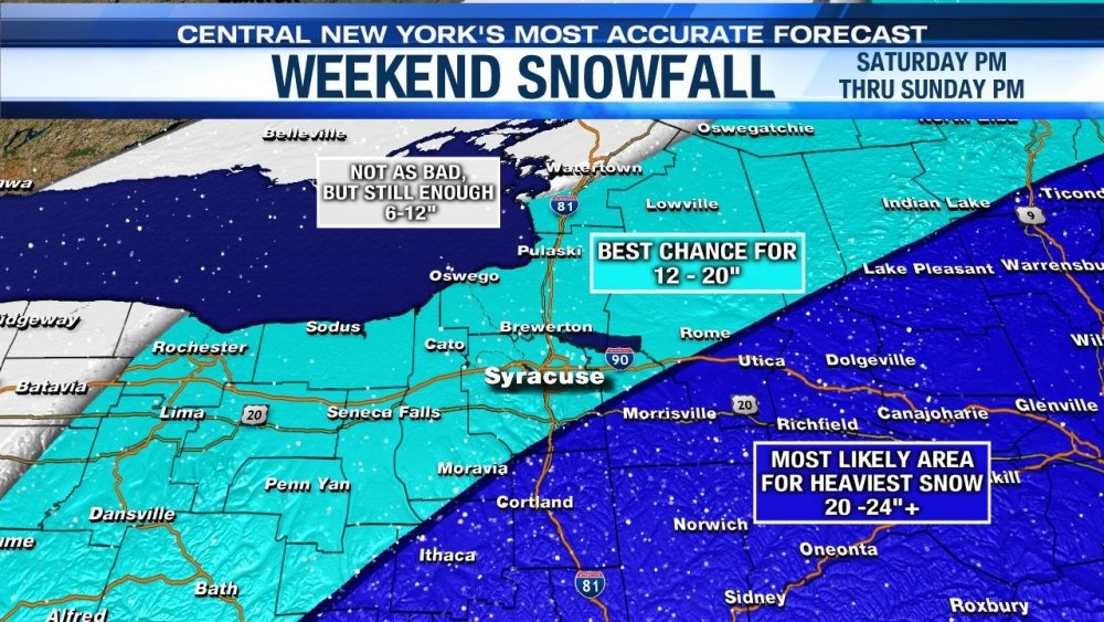
Write up from Channel 9 in Syracuse chief meteorologist Jim Teske: I'll just add a few notes for tonight's post about the weekend storm. IMPACTS: Arrival time looks to be about the same with something early in the afternoon. Remember, just because a Winter Storm Watch starts at 1 pm doesn't mean it starts snow hard at that time. The snow will be steady but relatively light through sunset. Heaviest snow begins in the evening and peaks overnight Saturday with snowfall rates of 1 - 2 inches and hour. It seems like the threat for real heavy snow is through about 8 or 9 am Sunday then lighter snow. However, wind will whip this snow around. It is not a wet snow so I would expect quite a bit of blowing and drifting. SNOWFALL AMOUNTS: I'm re posting our snowfall accumulation map. When forecasting the snowfall amounts this time around we really keyed in on temperatures. During the duration of the event we should be in the teens, not the 20s to near 30 like you might see in widespread snows like this. Why is this important? With these colder temperatures we end up squeezing more snow. If this snow occurred with a temperature around 25 - 28 we might forecast something closer to 8-12" However, with the colder temperatures we've ramped it up to 12-20" for Syracuse. LAKE EFFECT: We are still watching for lake effect Sunday night into Monday but two things seem to be working against a big accumulation for Syracuse. 1) The air is trying to dry out and 2) the wind direction seems to be a bit more northerly then the models were forecasting early in the week. Right now the best chance for an additional accumulation from lake effect looks to be over the Finger Lakes west of Syracuse. We'll keep you posted on the exact amounts as we get closer. That's all for now. Don't forget to join me on Facebook Live Thursday night at 8:45 pm.
-
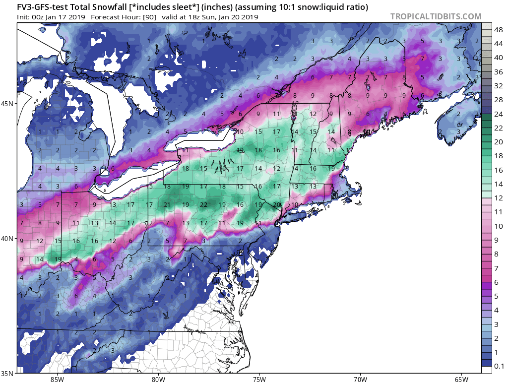
FV3 seems to be holding serve on the track, just a few hours faster and a couple mb weaker.
-
Channel 9’s latest accumulation forecast.
-
What is Toronto’s yearly average snowfall? Being on the wrong end of Lake Ontario and not in a favorable synoptic location it’s probably fairly low.
-
The snowpack being built up in the Sierras should be a big help for agriculture in the Central Valley this summer.
-
BGM snowfall map. It was made before the 12Z runs.
-
-
I just had the Weather Channel on and they seem to be leaning heavily on the Euro. Almost seems like they want heavy snow to fall on Boston. Cantore mentioned 40 inches for Nashua, NH!
-
Is this the first big battle between the new American kid, the FV3, and the Euro? If the Euro just moved NW on the 6Z run, did our boy just deliver a body blow?
-
I’ll take the FV3

-
URGENT - WINTER WEATHER MESSAGE National Weather Service Buffalo NY 213 PM EST Wed Jan 16 2019 NYZ001>008-010>014-019>021-085-170715- /O.NEW.KBUF.WS.A.0003.190119T1800Z-190121T2300Z/ Niagara-Orleans-Monroe-Wayne-Northern Cayuga-Oswego-Jefferson- Lewis-Northern Erie-Genesee-Wyoming-Livingston-Ontario-Chautauqua- Cattaraugus-Allegany-Southern Erie- Including the cities of Niagara Falls, Medina, Rochester, Newark, Fair Haven, Oswego, Watertown, Lowville, Buffalo, Batavia, Warsaw, Geneseo, Canandaigua, Jamestown, Olean, Wellsville, Orchard Park, and Springville 213 PM EST Wed Jan 16 2019 ...WINTER STORM WATCH IN EFFECT FROM SATURDAY AFTERNOON THROUGH MONDAY AFTERNOON... * WHAT...Heavy snow possible. Light snow will begin as early as Saturday morning. Snow will become heavy Saturday night and continue into Sunday. Snow will then transition to lake effect Sunday night and continue through Monday. At this time, greater than 7 inches of snow is possible. Gusty winds and arctic air will also produce blowing and drifting snow and wind chills well below zero. * WHERE...All of western and north central New York. * WHEN...From Saturday afternoon through Monday afternoon. * ADDITIONAL DETAILS...Plan on slippery road conditions. Widespread blowing snow could significantly reduce visibility. PRECAUTIONARY/PREPAREDNESS ACTIONS... Begin needed preparations at home or with your vehicle. Travel may become difficult, so plan accordingly. &&
-
What about Brexit, lol?
-
Snowing heavily here now.
-
Special Weather Statement National Weather Service Binghamton NY 1238 PM EST WED JAN 16 2019 NYZ009-018-036-037-161845- Onondaga-Southern Oneida-Madison-Northern Oneida- 1238 PM EST WED JAN 16 2019 ...A SNOW SQUALL WILL AFFECT ONEIDA...NORTHWESTERN MADISON AND NORTHERN ONONDAGA COUNTIES... At 1238 PM EST, a snow squall was located along a line extending from 7 miles northwest of Old Forge to near Plainville. Movement was east at 45 mph. Winds in excess of 30 mph are possible with this squall. Locations impacted include... Syracuse, Utica, Clay, Rome, Cicero, De Witt, Sullivan, Van Buren, Oneida and Kirkland.
-
You could bet the over/under on snowfall amounts!
-
I could see the taint if I look down Oneida Lake!