coastalplainsnowman
-
Posts
977 -
Joined
-
Last visited
Content Type
Profiles
Blogs
Forums
American Weather
Media Demo
Store
Gallery
Everything posted by coastalplainsnowman
-
Sorry, last post like this. From the WeatherStar3000 app I linked to earlier.
-
If you really want nostalgia, try out this link. Uses your location and current NWS forecast to create a spot-on 1980s TWC local update. Amazing. https://weatherstar3000.netbymatt.com/
-
It's ok, nothing crazy yet. Hoping before this is all over to rival the best I've ever seen here (12/30/2000.)
-
"People be crazy." Well there's something we can all agree on.
-
Speaking of which at some point would love to get you and other mets / technical folks take on what you think about on air mets increasingly showing the models and kind of deferring to them, rather than interpreting them along with all their other inputs and making a forecast. Just showing me, for example, that the GFS gives us a foot and the Euro gives us 2" doesn't really tell me anything, other than that it might snow or it might not.
-
I.. must...resist...injecting...politics... Ok I looked at a snow map, I'm good.
-
There's something poetic and sage about this reply. It's like 8 consecutive meteorological fortune cookies back to back.
-
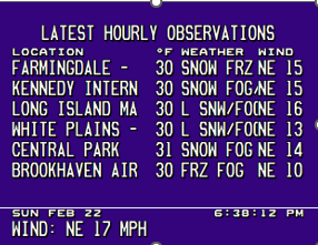
NYC 28 LGA 30 ISP 31 JFK 29 EWR 32
-
And all this time I thought it was a reference to the teacher in the Archie comic strip, Mr. Weatherbee lol
-
That was the early March 2001 one where there were TWC maps with 3 ft in these parts, right? That was astounding and might as well have said 8 ft. How close to the expected start time did it become apparent that it would not be happening? Also, wasn't that another case where it was on the radar a week or six days out, then the models lost it, then it was back on the radar 4 days out but in a somewhat different form? Lastly, that was 25 years ago next week. Good God.
-
"overflow error"
-
I can't tell you how many times I've broken away to catch up on emails only to find myself back here scrolling, not remembering ever making the conscious decision to flip back here..
-
Thanks - I'm sure and I wouldn't doubt you at all. I'm just saying that I haven't seen that pan out much, just like the elusive rain that changes back to snow, and the 'this storm will be going strong for 36 hours' which seems to always fall short. Maybe I'm really asking for it though making this argument with this particular storm.
-
I think that last map broke JerseyShoreWxGuy
-
Not to tempt fate, but I'll believe the wind part of this when I see (edit: feel) it. Big wind numbers seem to very often be way overdone, or at least very isolated. Can't tell you how many times I've been out in a storm in which it was snowing hard enough for sure, but was practically calm when high winds were forecast.
-
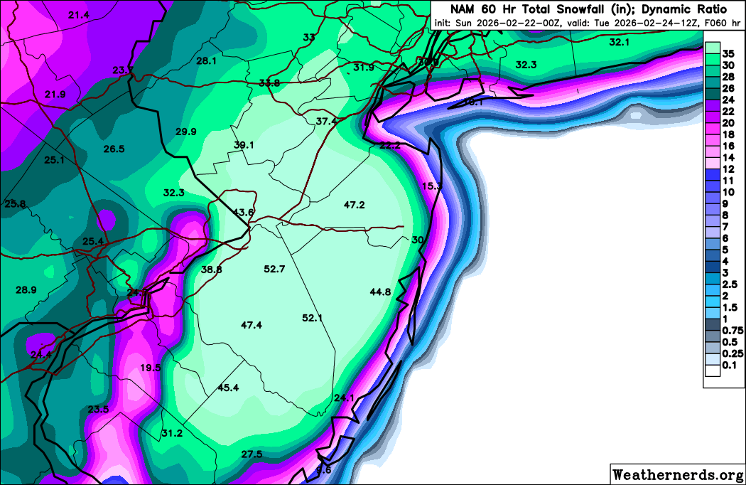
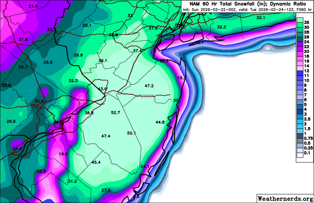
These maps are actually running out of colors in their keys.
-
Looking forward to watching via my favorite cam there
-
On the bright side, who is going to do anything about it. And if you do the neighbor's sidewalk they'll never rat you out.
-
As someone I know said after visiting Home Depot today, "It's as if we're in spring. you'd have no idea there was a storm coming" because they have absolutely nothing left.
-
Also, again no matter what the outcome, for the next 30 years, the optimistic folks who like to say in the darkest hour of a dying threat "hey, sometimes all the models lose the storm and then bring it back" now have a great example to point to. "Well, remember back in 2026.."
-
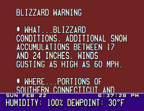
I just learned that the NWS Hazardous Outlook page is available in multiple languages As a result, I am proud to say that I can now say Blizzard Warning in three languages: Spanish:Aviso de Ventisca French: Avertissement de blizzard English: Blizzard Warning
-
And yet their forecast continues to call for 6-10." I know those two things are not mutually exclusive, but just seems like WABC's hype machine is out of sync with the very weather forecast provider that they tout in the headline.
-
If there was an amen emoji available I would use it here.
-
This is great info, thank you. I was going to just click the Thanks emoji as I did and leave it that since I had nothing meaningful to contribute, except to say that I noticed this morning that as of the latest update the High End was kept in the update, but the Low End was dropped entirely. I'm guessing that's out of concern that whatever it might have currently shown, people will see that and not t take this seriously, in an update where 'take this seriously' is rightly the whole point.
-
Agreed. We here can imagine the possibilities without risk of being ridiculed for all eternity like he would be if he called for 30" and we ended up with 4. Upton's unprecedented High End / Low End disparity of 24-30" at one end and 0.5" at the other is off putting to me. I don't think I've seen even an 8" forecast storm with a 0.5" low end. Whatever is driving that would spook me from putting any huge numbers up too. You call for 15" and you get 25", no one will remember. You call for 25" and get 0.5" , no one will forget, ever.