

donsutherland1
-
Posts
23,768 -
Joined
Content Type
Profiles
Blogs
Forums
American Weather
Media Demo
Store
Gallery
Everything posted by donsutherland1
-
December 22nd - 23rd Cutter Discussion and Observations
donsutherland1 replied to NJwx85's topic in New York City Metro
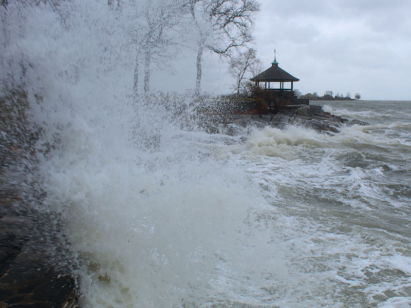
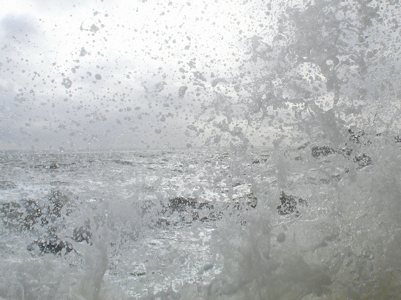
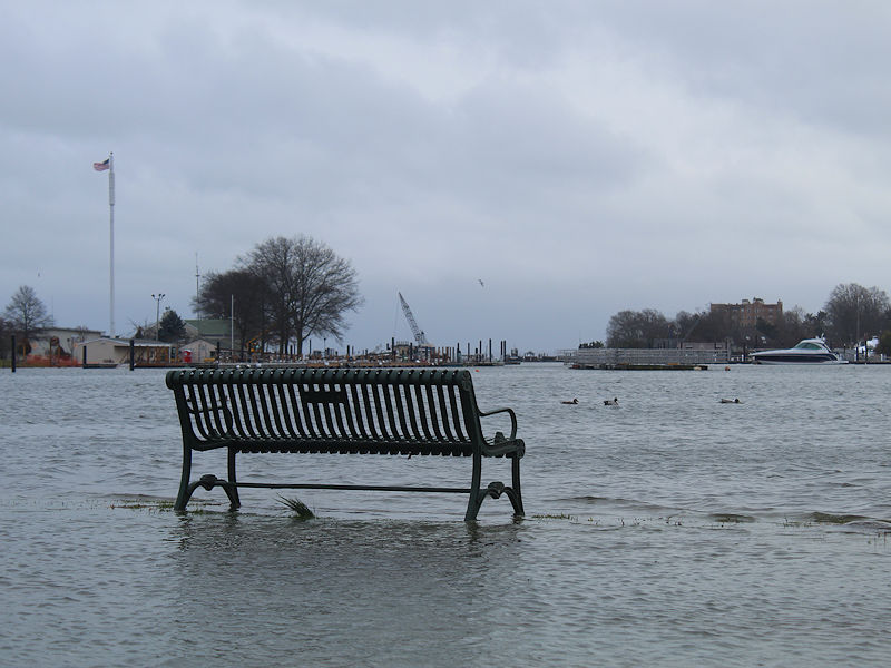
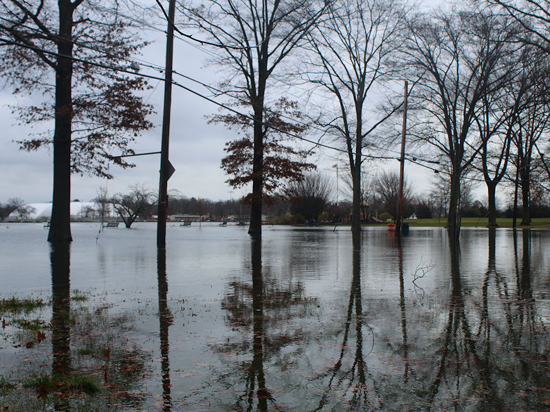
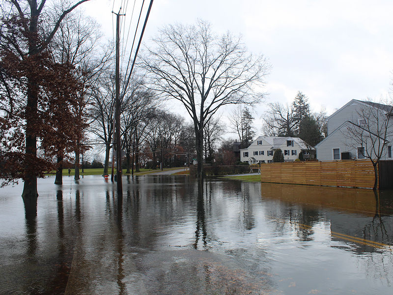
Some scenes from today along the Long Island Sound, including coastal flooding.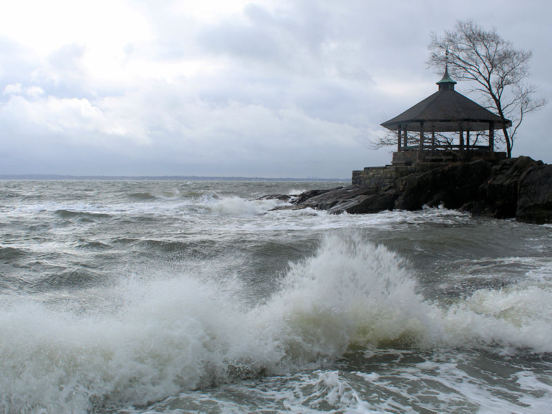
-
Historic Christmas Lake Effect Blizzard
donsutherland1 replied to BuffaloWeather's topic in Upstate New York/Pennsylvania
Perhaps it is. Nevertheless, very heavy snow is falling. -
December 22nd - 23rd Cutter Discussion and Observations
donsutherland1 replied to NJwx85's topic in New York City Metro
It is now snowing in Larchmont -
Historic Christmas Lake Effect Blizzard
donsutherland1 replied to BuffaloWeather's topic in Upstate New York/Pennsylvania
Buffalo Observation: 0 visibility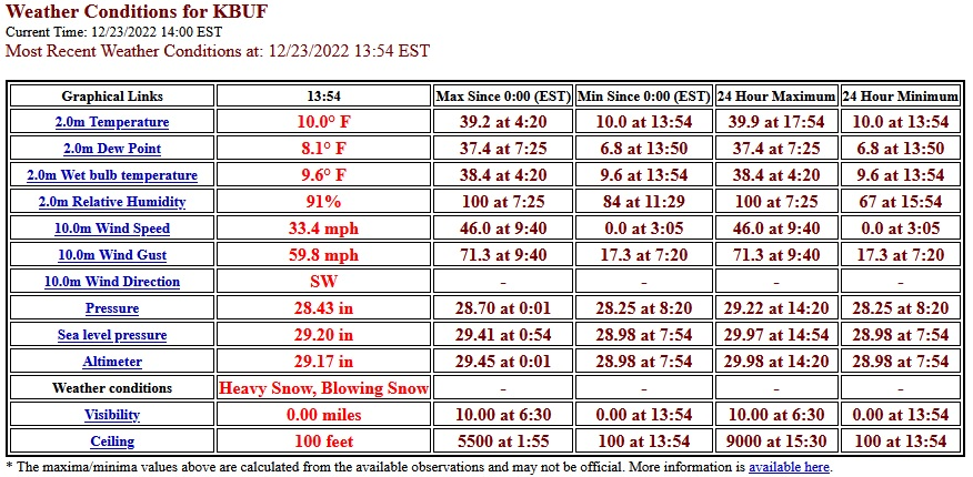
-
December 22nd - 23rd Cutter Discussion and Observations
donsutherland1 replied to NJwx85's topic in New York City Metro
Front is coming through with high winds and some rain in Larchmont, NY. -
Near the start of January or just afterward, if the ensembles are correct.
-
It could be a week later. Afterward, it's difficult to associate it with the blocking. P.S. Buffalo has seen the passage of the Arctic cold front. There is currently heavy lake effect snow with 1/8 mile visibility.
-
It is remarkable. This would be a rare event.
-
None. The record low for the 11 prior Decembers with a -4 AO is 0.5" in December 1978.
-
Morning thoughts… It will be rainy, windy, and mild this morning. Temperatures will fall throughout the day and reach the lower 20s and even teens by this evening. Significant coastal flooding is likely at this morning’s high tide. Temperatures will fall sharply late in the day. Likely high temperatures around the region include: New York City (Central Park): 52° Newark: 55° Philadelphia: 48° Despite sunshine, it will be very cold tomorrow and Sunday. Normals: New York City: 30-Year: 42.3°; 15-Year: 43.2° Newark: 30-Year: 42.8°; 15-Year: 43.9° Philadelphia: 30-Year: 44.1°; 15-Year: 45.1°
-
There’s no tropical connection this time.
-
Casper did.
-
From 4 am to 5 am EST, New York City picked up a preliminary 1.33" of rainfall. That would be the first documented case of 1" or more hourly rainfall during the November-February period. The previous latest-season 1"+ rainfall occurred on October 23, 1912 when 1.31" fell.
-
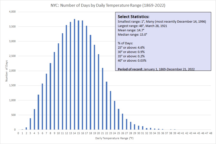
As Arctic air presses into New York City tomorrow, Central Park will likely see a daily temperature range of 30°F or above. Typically, NYC sees 3.3 such days per year. 2022 has seen 3 such days so far: February 4 (31°), February 18 (36°), and February 23 (33°).
-
A powerful storm will continue to bring heavy rain, high winds, and coastal flooding to the region tonight and tomorrow. A storm total 1"-2" of precipitation appears likely with locally higher amounts. A few spots could reach 3" or precipitation. A light snow accumulation remains possible as the storm moves away from the region, largely in interior sections. A flash freeze remains possible tomorrow. In the wake of the storm, the season's coldest air so far will pour into the region. Temperatures will tumble into the teens in in New York City by evening and low teens overnight. Some locations outside the City could see single-digit lows. Nevertheless, the core of the Arctic air mass will bypass the New York City region. Sunday will be fair and continued very cold before slow moderation commences early next week. The AO fell reached -4.000 on December 10th. Since 1950, there were 11 cases that saw the AO reach -4.000 or below during December. Mean snowfall for those cases was 9.0" (Median: 9.1"). 64% of such cases saw 6" or more of snowfall in December while 45% of such cases saw 10.0" or more snow. In contrast, during all other December cases, mean December snowfall was 3.5" (Median: 2.5"). 91% of those cases also saw a colder than normal December in the northern Middle Atlantic region. In terms of seasonal snowfall, 64% of those seasons saw 30" or more snowfall in New York City with 45% having 40" or more. Just 18% of such cases had less than 20" seasonal snowfall, both of which had less than 10" for the December-January period. However, there are cases where Decembers with strong blocking have seen much below normal snowfall. The three cases with less than 1" of monthly snowfall with a monthly average AO of -1.500 or below were: 1985: 0.9" (total seasonal snowfall: 13.0"); 1996: Trace (total seasonal snowfall: 10.0"); and, 2012: 0.4" (total seasonal snowfall: 26.1"). The lowest December snowfall when the AO averaged -2.000 or below was 5.1" in 1976. The lowest winter month snowfall with a monthly average AO of -2.000 or below was 0.5" in January 1998. There is a chance that both futility records could be surpassed this month. The ENSO Region 1+2 anomaly was -0.1°C and the Region 3.4 anomaly was -0.9°C for the week centered around December 14. For the past six weeks, the ENSO Region 1+2 anomaly has averaged -0.95°C and the ENSO Region 3.4 anomaly has averaged -0.92°C. La Niña conditions will likely persist through mid-winter. The SOI was +55.74 today. That smashed the daily record high of +44.34 from 2003. It was also the highest SOI reading since April 2, 2011 when the SOI reached +62.15. The preliminary Arctic Oscillation (AO) was -3.374 today. On December 20 the MJO was in Phase 4 at an amplitude of 0.792 (RMM). The December 19-adjusted amplitude was 0.476 (RMM). Based on sensitivity analysis applied to the latest guidance, there is an implied 87% probability that New York City will have a colder than normal December (1991-2020 normal). December will likely finish with a mean temperature near 37.3° (1.8° below normal).
-
It is. At least for now, that’s the “new normal” for large-scale Arctic blasts.
-
From the November 7-8, 2012 snowstorm following Sandy:
-
New all-time low temperature record: This morning, the temperature fell to -42° at Casper, WY. That smashed the daily record of -33°, which was set in 1983. It also surpassed the December and all-time record of -41° from December 21, 1990.
-
Morning thoughts… A soaking rain will arrive during the late morning or early afternoon hours. High temperatures will reach the upper 40s and lower 50s in most of the region. Likely high temperatures around the region include: New York City (Central Park): 52° Newark: 53° Philadelphia: 54° It will be rainy and windy tomorrow. Afterward, it will turn sharply colder. Normals: New York City: 30-Year: 42.5°; 15-Year: 43.4° Newark: 30-Year: 43.0°; 15-Year: 44.1° Philadelphia: 30-Year: 44.3°; 15-Year: 45.3° The Southern Oscillation Index (SOI) rose to +55.74 today. That is the highest figure since April 2, 2011 when the SOI stood at +62.15.
-
The winter solstice was marked by calm but cold weather. However, the meteorological quiet is about to end. Already, an major Arctic blast is sending temperatures tumbling in the Plains states. Cheyenne went from a high of 42° to a current reading of -12°. Denver saw the temperature dive from a high of 51° to a current figure of -1°. While the cold won't be as severe and its arrival won't be as dramatic late Friday or Friday night, its will send thermometers to their lowest levels so far this winter. A powerful storm will bring heavy rain, high winds, and coastal flooding to the region tomorrow and Friday. The rain will arrive during the late morning or early afternoon. A general 1"-2" of precipitation appears likely with locally higher amounts. A few spots could reach 3" or precipitation. A light snow accumulation remains possible at the onset of the storm and as it moves away from the region, largely in interior sections. A flash freeze remains possible. Once that storm passes, the season's coldest air so far will pour into the region. Temperatures will tumble into the teens in New York City. Nevertheless, the core of the Arctic air mass will bypass the New York City region. The AO fell reached -4.000 on December 10th. Since 1950, there were 11 cases that saw the AO reach -4.000 or below during December. Mean snowfall for those cases was 9.0" (Median: 9.1"). 64% of such cases saw 6" or more of snowfall in December while 45% of such cases saw 10.0" or more snow. In contrast, during all other December cases, mean December snowfall was 3.5" (Median: 2.5"). 91% of those cases also saw a colder than normal December in the northern Middle Atlantic region. In terms of seasonal snowfall, 64% of those seasons saw 30" or more snowfall in New York City with 45% having 40" or more. Just 18% of such cases had less than 20" seasonal snowfall, both of which had less than 10" for the December-January period. However, there are cases where Decembers with strong blocking have seen much below normal snowfall. The three cases with less than 1" of monthly snowfall with a monthly average AO of -1.500 or below were: 1985: 0.9" (total seasonal snowfall: 13.0"); 1996: Trace (total seasonal snowfall: 10.0"); and, 2012: 0.4" (total seasonal snowfall: 26.1"). The lowest December snowfall when the AO averaged -2.000 or below was 5.1" in 1976. The lowest winter month snowfall with a monthly average AO of -2.000 or below was 0.5" in January 1998. There is a chance that both futility records could be surpassed this month. The ENSO Region 1+2 anomaly was -0.1°C and the Region 3.4 anomaly was -0.9°C for the week centered around December 14. For the past six weeks, the ENSO Region 1+2 anomaly has averaged -0.95°C and the ENSO Region 3.4 anomaly has averaged -0.92°C. La Niña conditions will likely persist through mid-winter. The SOI was +37.88 today. The preliminary Arctic Oscillation (AO) was -3.327 today. On December 19 the MJO was in Phase 3 at an amplitude of 0.478 (RMM). The December 18-adjusted amplitude was 0.635 (RMM). Based on sensitivity analysis applied to the latest guidance, there is an implied 85% probability that New York City will have a colder than normal December (1991-2020 normal). December will likely finish with a mean temperature near 37.3° (1.8° below normal).
-
Speaking about temperature drops, the mercury has fallen from 43° at 1:05 pm MST to 10° at 1:15 pm MST at Cheyenne.
-
Morning thoughts… Today will be partly to mostly sunny and cool. High temperatures will reach the upper 30s and lower 40s in most of the region. Likely high temperatures around the region include: New York City (Central Park): 39° Newark: 41° Philadelphia: 41° A soaking rain will arrive tomorrow and continue through Friday. Afterward, it will turn sharply colder. Normals: New York City: 30-Year: 42.8°; 15-Year: 43.6° Newark: 30-Year: 43.3°; 15-Year: 44.3° Philadelphia: 30-Year: 44.5°; 15-Year: 45.6°
-
Dry but cool weather will continue through tomorrow. A powerful storm could bring heavy rain, high winds, and coastal flooding to the region Thursday and Friday. A general 1"-2" of precipitation appears likely with locally higher amounts. A light snow accumulation remains possible at the onset of the storm and as it moves away from the region. A flash freeze is possible. Once that storm passes, the season's coldest air so far will pour into the region. Temperatures could tumble into the teens in New York City. Nevertheless, the core of the Arctic air mass will bypass the New York City region. As a result, New York City's ongoing record 1,419-day streak without a single-digit temperature will be extended. The last time Central Park saw a temperature below 10° was January 31, 2019 when the mercury dipped to 2°. The AO fell reached -4.000 on December 10th. Since 1950, there were 11 cases that saw the AO reach -4.000 or below during December. Mean snowfall for those cases was 9.0" (Median: 9.1"). 64% of such cases saw 6" or more of snowfall in December while 45% of such cases saw 10.0" or more snow. In contrast, during all other December cases, mean December snowfall was 3.5" (Median: 2.5"). 91% of those cases also saw a colder than normal December in the northern Middle Atlantic region. In terms of seasonal snowfall, 64% of those seasons saw 30" or more snowfall in New York City with 45% having 40" or more. Just 18% of such cases had less than 20" seasonal snowfall, both of which had less than 10" for the December-January period. However, there are cases where Decembers with strong blocking have seen much below normal snowfall. The three cases with less than 1" of monthly snowfall with a monthly average AO of -1.500 or below were: 1985: 0.9" (total seasonal snowfall: 13.0"); 1996: Trace (total seasonal snowfall: 10.0"); and, 2012: 0.4" (total seasonal snowfall: 26.1"). The lowest December snowfall when the AO averaged -2.000 or below was 5.1" in 1976. The lowest winter month snowfall with a monthly average AO of -2.000 or below was 0.5" in January 1998. There is a chance that both futility records could be surpassed this month. The ENSO Region 1+2 anomaly was -0.1°C and the Region 3.4 anomaly was -0.9°C for the week centered around December 14. For the past six weeks, the ENSO Region 1+2 anomaly has averaged -0.95°C and the ENSO Region 3.4 anomaly has averaged -0.92°C. La Niña conditions will likely persist through mid-winter. The SOI was +20.19 today. The preliminary Arctic Oscillation (AO) was -3.327 today. On December 18 the MJO was in Phase 3 at an amplitude of 0.636 (RMM). The December 17-adjusted amplitude was 0.642 (RMM). Based on sensitivity analysis applied to the latest guidance, there is an implied 81% probability that New York City will have a colder than normal December (1991-2020 normal). December will likely finish with a mean temperature near 37.6° (1.5° below normal).
-
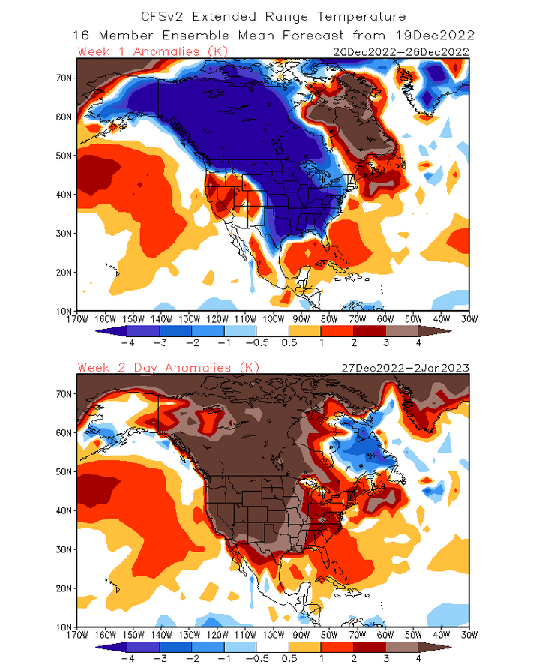
The CFSv2 has a really dramatic flip in weekly anomalies. It is almost as if it has embraced the rule "where there was blue, let there be orange and brown." Yesterday's EPS weeklies had a more muted flip. Whether this is an intermission after what appears likely to be a disappointing opening act to winter despite a notable Arctic blast or something more sinister remains to be seen.
-
Morning thoughts… Today will be partly to mostly sunny and cool. High temperatures will reach mainly the upper 30s in most of the region. Likely high temperatures around the region include: New York City (Central Park): 38° Newark: 40° Philadelphia: 39° The dry weather will continue through tomorrow. Normals: New York City: 30-Year: 43.0°; 15-Year: 43.8° Newark: 30-Year: 43.5°; 15-Year: 44.5° Philadelphia: 30-Year: 44.8°; 15-Year: 45.8°


