donsutherland1
-
Posts
23,765 -
Joined
Content Type
Profiles
Blogs
Forums
American Weather
Media Demo
Store
Gallery
Everything posted by donsutherland1
-
Tomorrow through Thursday will see additional rainfall with highs in the 40s. A general 1"-3" rainfall with locally higher amounts is likely through Thursday. Coastal flooding at times of high tide is likely. Central and upstate New York and central and northern New England could see accumulating snow, especially in higher elevations and away from the coastline. After a cool first week of April, it will likely turn noticeably warmer during the second week. It is very likely that New York City's Central Park will finish the 2023-2024 snow season with less than 10" of seasonal snowfall for a record second consecutive season. Records go back to 1869. The ENSO Region 1+2 anomaly was -0.4°C and the Region 3.4 anomaly was +1.0°C for the week centered around March 20. For the past six weeks, the ENSO Region 1+2 anomaly has averaged +0.42°C and the ENSO Region 3.4 anomaly has averaged +1.27°C. The ongoing basinwide El Niño event is fading. Neutral conditions could develop later in the spring. The SOI was -10.53 today. The preliminary Arctic Oscillation (AO) was -1.192 today.
-
Significant Miller B Nor'easter watch, Apr 3rd-4th
donsutherland1 replied to Typhoon Tip's topic in New England
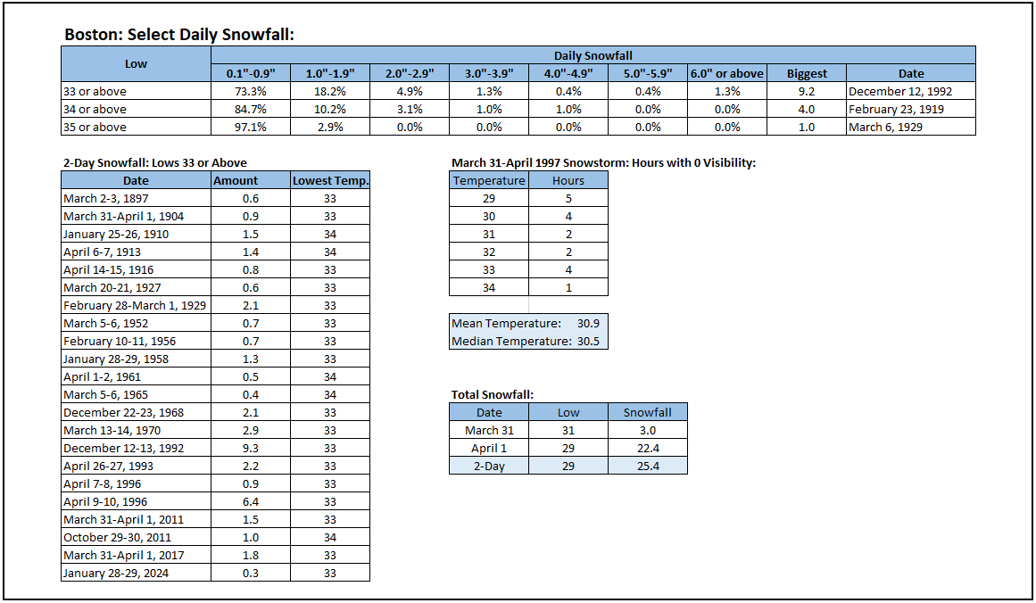
Both the 12z GGEM and GFS show a significant snowfall (6"+) across most of southern New England, including the Greater Boston area. The 0z GGEM had shown March 31-April 1997-type amounts for Boston. More likely significant snowfall will be confined to interior sections, as well as higher elevations rather than the Greater Boston area, as readings in Boston are forecast to remain above freezing on both the GFS and GGEM. A somewhat colder air mass would change things. Here's how Boston has fared for the 225 days during which measurable snow was reported and the low temperature was 33° or above. The highest 1-day totals were: 33°F or above: 9.2", December 12, 1992 34°F or above: 4.0", February 23, 1919 The highest 2-day totals were: 33°F or above: 9.3", December 12-13, 1992 34°F or above: 4.0", February 23, 1919 A significant portion of the March 31-April 1997 snowstorm occurred with temperatures at or below freezing.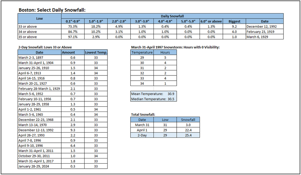
-
Occasional Thoughts on Climate Change
donsutherland1 replied to donsutherland1's topic in Climate Change
Unfortunately, the film lacks scientific merit. It makes numerous claims that run counter to scientific understanding ranging from the basics of the greenhouse effect (which has been understood since the 19th century) to warming being an artifact of the urban heat island (UHI effect--UHI is real, but rural locations have been warming, too). The impact of adding greenhouse gases to the Earth System is a matter of physics, not politics. The Earth Energy Imbalance that has resulted is driving warming, as incoming solar radiation exceeds outgoing longwave radiation. The geological record provides further illustrations of the role CO2 has played in amplifying the warming, even as past triggers for increasing atmospheric CO2 were natural. It makes no difference whether CO2 is released through volcanic activity or from the burning of fossil fuels. The effects are the same given the well-understood properties of the gas. There remain some questions about whether sensitivity to increasing CO2 also ramps up at some point. Recent research suggests that it does on account of a decrease in low- and medium-level cloud cover at the mid- and high-latitudes, allowing more incoming solar radiation to reach the surface than would otherwise be the case. Not surprisingly, summing up the body of research, science journalist Peter Brannen observed, "...our current experiment--quickly injecting huge amounts of carbon dioxide into the atmosphere--has in fact been run many times before in the geological past, and it never ends well." The warming is just one problem. Most of the CO2 is absorbed by the oceans leading to acidification. The combination of acidification and warming reduces oxygen (even as sea life needs more oxygen to deal with warmer temperatures), which can create food chain die-offs. Recent bleaching events of corals off Florida and Australia are early symptoms of what could become a much bigger problem if the issue is not addressed in a sufficient and timely matter. And what happens in the sea doesn't stay in the sea. A substantial loss of sea life would be felt by human society. There would be no quick fixes. In the end, the film trivializes what is a major issue with profound consequences. It seeks to delay societal action by injecting disinformation into the public sphere. The costs of a delayed response could be magnitudes of order greater than those associated with earlier efforts to address the problem. -
Final numbers:
-
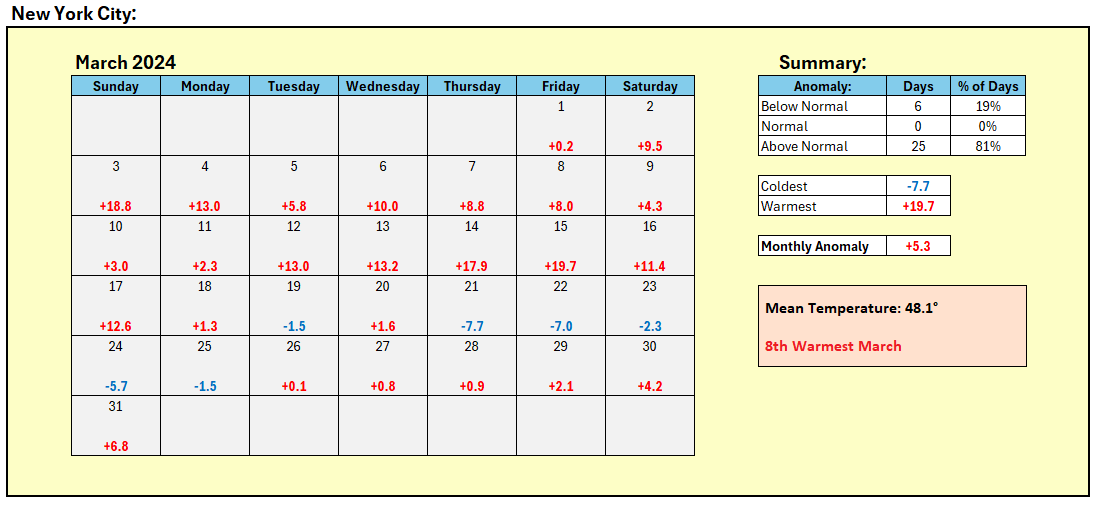
March 2024 finished with a mean temperature of 48.1° in New York City. That ranked as the 8th warmest March on record. The 9.04" of precipitation ranked as the 4th highest on record. 2010 and 2024 are the only two years to rank in the Top 10 for both categories in March. In addition, with an average temperature of 42.5°, December 1, 2023 - March 31, 2024 was the 3rd warmest December-March period on record. All of the 6 warmest December-March periods have occurred since 2000. Five of them have occurred since 2010: 2011-2012 (1st), 2015-2016 (2nd), 2019-2020 (6th), 2022-2023 (4th), and 2023-2024 (3rd). This outcome is consistent with climate change that is producing ongoing warming. Specifically, periods of rain will develop overnight and continue tomorrow. Temperatures will likely top out in the lower 50s. Tuesday through Thursday will see additional rainfall with highs in the 40s. Central and upstate New York and central and northern New England could see accumulating snow during the week. The precipitation will add to the impressive totals that have accumulated since January 1st. January 1-March 31 precipitation includes: Albany: 11.89" (4th highest) Allentown: 13.79" (8th highest) Atlantic City: 18.22" (1st highest) Bangor: 13.41" (6th highest) Binghamton: 10.98" (3rd highest) Boston: 17.23" (8th highest) Bridgeport: 18.30" (2nd highest) Concord: 15.04" (6th highest) Hartford: 18.23" (2nd highest) Islip: 19.23" (4th highest) Manchester: 14.41" (9th highest) Mount Pocono: 18.08" (3rd highest) New York City-Central Park: 16.37" (4th highest) New York City-JFK Airport: 17.40" (1st highest) New York City-LaGuardia Airport: 17.29" (1st highest) Newark: 15.26" (7th highest) Philadelphia: 14.59" (7th highest) Portland: 19.59" (Tied 4th highest) Poughkeepsie: 12.72" (7th highest) Providence: 23.85" (2nd highest) Trenton: 15.20" (7th highest) White Plains: 16.20" (3rd highest) Wilmington, DE: 15.22" (5th highest) Worcester: 18.10" (3rd highest) It is very likely that New York City's Central Park will finish the 2023-2024 snow season with less than 10" of seasonal snowfall for a record second consecutive season. Records go back to 1869. The ENSO Region 1+2 anomaly was -0.1°C and the Region 3.4 anomaly was +1.3°C for the week centered around March 20. For the past six weeks, the ENSO Region 1+2 anomaly has averaged +0.67°C and the ENSO Region 3.4 anomaly has averaged +1.35°C. The ongoing basinwide El Niño event is continuing to fade with the ENSO Region 1+2 anomaly going negative for the first time since the week centered around January 25, 2023. Neutral conditions could develop later in the spring. The SOI was -10.29 today. The preliminary Arctic Oscillation (AO) was -1.419 today.
-
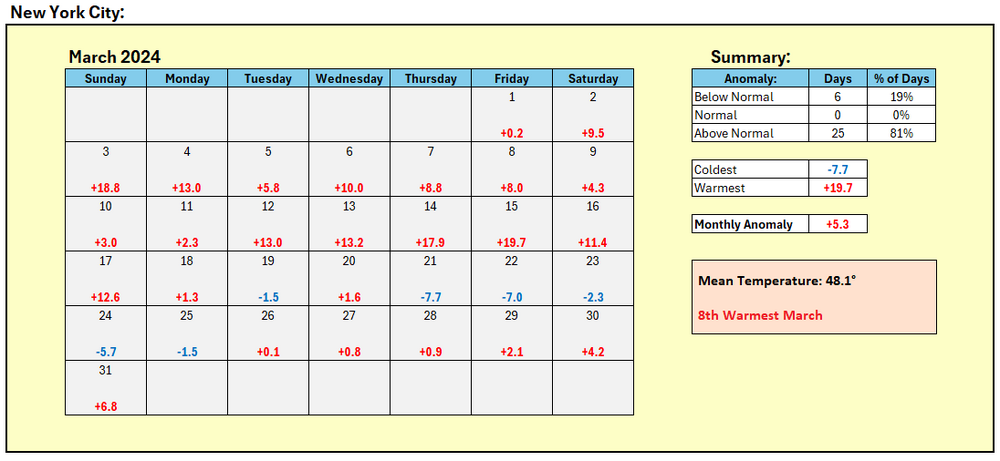
March was the 8th warmest month on record in New York City. Just over 4 out of every 5 days saw above normal temperatures.
-
No. None of them reached 10.00".
-
DCA _ NYC _ BOS __ ORD _ ATL _ IAH __ DEN _ PHX _ SEA 1.5 1.5 1.2 1.7 0.3 0.0 0.5 -0.8 0.8
-
A few showers are likely tonight into early tomorrow morning. Afterward, the clouds will give way to sunshine and temperatures will rise into the upper 50s and lower 60s. Some of the warmer spots could top out in the middle 60s. The week ahead looks to feature wet and unseasonably cool weather. Temperatures could be confined mainly to the 40s with occasional chilly rain. Central and upstate New York and central and northern New England could see accumulating snow. It is very likely that New York City's Central Park will finish the 2023-2024 snow season with less than 10" of seasonal snowfall for a record second consecutive season. Records go back to 1869. The ENSO Region 1+2 anomaly was -0.1°C and the Region 3.4 anomaly was +1.3°C for the week centered around March 20. For the past six weeks, the ENSO Region 1+2 anomaly has averaged +0.67°C and the ENSO Region 3.4 anomaly has averaged +1.35°C. The ongoing basinwide El Niño event is continuing to fade with the ENSO Region 1+2 anomaly going negative for the first time since the week centered around January 25, 2023. Neutral conditions could develop later in the spring. The SOI was -6.85 today. The preliminary Arctic Oscillation (AO) was -0.849 today. Based on sensitivity analysis applied to the latest guidance, there is an implied near 100% probability that New York City will have a warmer than normal March (1991-2020 normal). March will likely finish with a mean temperature near 48.1° (5.4° above normal).
-
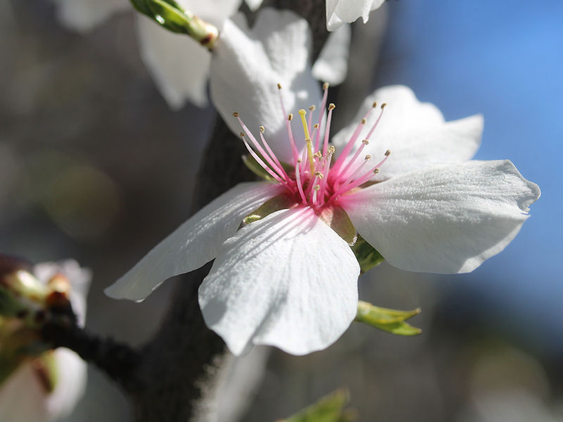
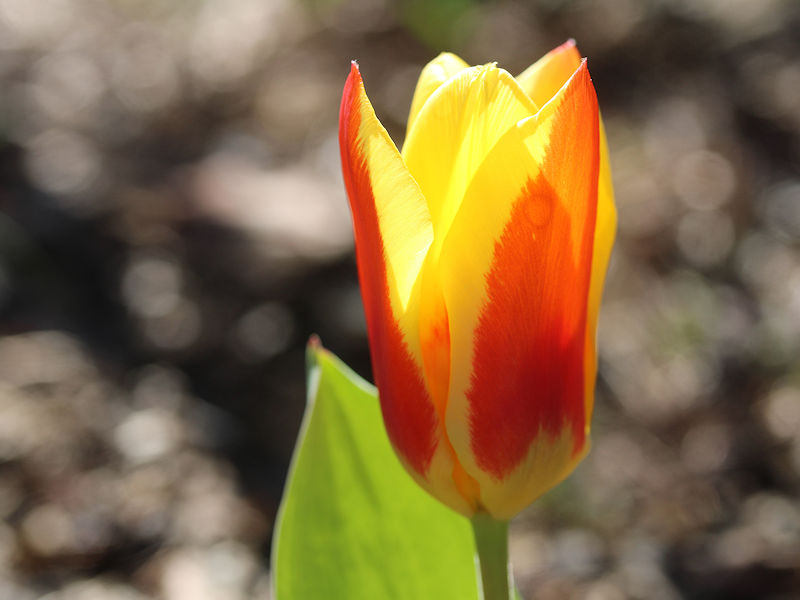
Despite the brief cold shot and recent rains, nature continues to advance deeper into spring at the New York Botanical Garden. Not even the 3/30 12z GGEM has frightened nature into slowing down the unfurling of its blossoms. Four photos from today:


-
A generally dry weekend lies ahead, although a shower cannot be ruled out tomorrow night or early Sunday morning. Temperatures will top out in the upper 50s and perhaps lower 60s. It is very likely that New York City's Central Park will finish the 2023-2024 snow season with less than 10" of seasonal snowfall for a record second consecutive season. Records go back to 1869. The ENSO Region 1+2 anomaly was -0.1°C and the Region 3.4 anomaly was +1.3°C for the week centered around March 20. For the past six weeks, the ENSO Region 1+2 anomaly has averaged +0.67°C and the ENSO Region 3.4 anomaly has averaged +1.35°C. The ongoing basinwide El Niño event is continuing to fade with the ENSO Region 1+2 anomaly going negative for the first time since the week centered around January 25, 2023. Neutral conditions could develop later in the spring. The SOI was -11.97 today. The preliminary Arctic Oscillation (AO) was -0.636 today. Based on sensitivity analysis applied to the latest guidance, there is an implied near 100% probability that New York City will have a warmer than normal March (1991-2020 normal). March will likely finish with a mean temperature near 48.0° (5.3° above normal).
-
JFK Airport's period of record began in July 1948.
-
Through 10 pm, storm total rainfall amounts include: Atlantic City: 1.64" Boston: 1.37" Bridgeport: 1.19" Islip: 1.59" New Haven: 1.13" New York City: 0.76" Newark: 0.52" Philadelphia: 0.40" Providence: 1.54" White Plains: 0.52" Rain will end late tonight or early tomorrow with a storm total 0.50" - 1.50" rainfall with some locally higher amounts. the heaviest amounts will likely occur on Long Island. The closing days of March could turn warmer with widespread readings in the upper 50s and perhaps lower 60s. It is very likely that New York City's Central Park will finish the 2023-2024 snow season with less than 10" of seasonal snowfall for a record second consecutive season. Records go back to 1869. The ENSO Region 1+2 anomaly was -0.1°C and the Region 3.4 anomaly was +1.3°C for the week centered around March 20. For the past six weeks, the ENSO Region 1+2 anomaly has averaged +0.67°C and the ENSO Region 3.4 anomaly has averaged +1.35°C. The ongoing basinwide El Niño event is continuing to fade with the ENSO Region 1+2 anomaly going negative for the first time since the week centered around January 25, 2023. Neutral conditions could develop later in the spring. The SOI was -11.97 today. The preliminary Arctic Oscillation (AO) was -1.037 today. Based on sensitivity analysis applied to the latest guidance, there is an implied near 100% probability that New York City will have a warmer than normal March (1991-2020 normal). March will likely finish with a mean temperature near 48.0° (5.3° above normal).
-
The last time NYC had an average last freeze in April was 1961-1990.
-
Showers early this evening will precede another bout of steady rain for tomorrow into early Friday. A general 0.50" - 1.50" appears likely. the heaviest amounts will likely occur on Long Island. The closing days of March could turn warmer with widespread readings in the upper 50s. It is very likely that New York City's Central Park will finish the 2023-2024 snow season with less than 10" of seasonal snowfall for a record second consecutive season. Records go back to 1869. The ENSO Region 1+2 anomaly was -0.1°C and the Region 3.4 anomaly was +1.3°C for the week centered around March 20. For the past six weeks, the ENSO Region 1+2 anomaly has averaged +0.67°C and the ENSO Region 3.4 anomaly has averaged +1.35°C. The ongoing basinwide El Niño event is continuing to fade with the ENSO Region 1+2 anomaly going negative for the first time since the week centered around January 25, 2023. Neutral conditions could develop later in the spring. The SOI was -6.85 today. The preliminary Arctic Oscillation (AO) was -0.542 today. Based on sensitivity analysis applied to the latest guidance, there is an implied near 100% probability that New York City will have a warmer than normal March (1991-2020 normal). March will likely finish with a mean temperature near 47.9° (5.2° above normal).
-
Another storm will bring rain to the region from tomorrow night into at least late Thursday. A general 0.50" - 1.50" appears likely. The closing days of March could turn warmer with widespread readings in the upper 50s. It is very likely that New York City's Central Park will finish the 2023-2024 snow season with less than 10" of seasonal snowfall for a record second consecutive season. Records go back to 1869. The ENSO Region 1+2 anomaly was -0.1°C and the Region 3.4 anomaly was +1.3°C for the week centered around March 20. For the past six weeks, the ENSO Region 1+2 anomaly has averaged +0.67°C and the ENSO Region 3.4 anomaly has averaged +1.35°C. The ongoing basinwide El Niño event is continuing to fade with the ENSO Region 1+2 anomaly going negative for the first time since the week centered around January 25, 2023. Neutral conditions could develop later in the spring. The SOI was -5.17 today. The preliminary Arctic Oscillation (AO) was +0.560 today. Based on sensitivity analysis applied to the latest guidance, there is an implied near 100% probability that New York City will have a warmer than normal March (1991-2020 normal). March will likely finish with a mean temperature near 48.0° (5.3° above normal).
-
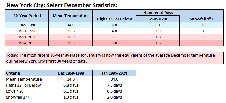
In his A Winter Season, James Fisher wrote December in Edinburgh in the early 19th century: In midst of dark December's howling blast, out from his quarters in the frigid zone comes surly Winter, in his car of iron, drawn on by furious, foaming, snow-white steeds, escorted by his angry northern band; which raves, and roars, and rages all around despoiling Nature of her every charm; and now sits down to storm her empire all… Falling rapidly, drifting on heaps, are the flakes of now, while the boisterous wind, roaring furiously, disbranches the trees, and threatens to overturn every habitation of man. To heighten the terrific scene... what a flash of lightning, followed by a tremendously loud clap of thunder! A lot of that could have applied to December in New York City during its first 30 years of record (1869-1898). December is now increasingly taking on the character of late November. The changes have been so dramatic that January today (1995-2024) is almost identical to what December was like during New York City’s first 30 years of recordkeeping.
-
The recent chill has now moderated. However, additional rain is likely late in the week. At present, a general 0.50" - 1.50" appears likely. The closing days of March could turn warmer with widespread readings in the upper 50s. It is very likely that New York City's Central Park will finish the 2023-2024 snow season with less than 10" of seasonal snowfall for a record second consecutive season. Records go back to 1869. The ENSO Region 1+2 anomaly was -0.1°C and the Region 3.4 anomaly was +1.3°C for the week centered around March 20. For the past six weeks, the ENSO Region 1+2 anomaly has averaged +0.67°C and the ENSO Region 3.4 anomaly has averaged +1.35°C. The ongoing basinwide El Niño event is continuing to fade with the ENSO Region 1+2 anomaly going negative for the first time since the week centered around January 25, 2023. Neutral conditions could develop later in the spring. The SOI was +1.82 today. The preliminary Arctic Oscillation (AO) was +0.180 today. Based on sensitivity analysis applied to the latest guidance, there is an implied near 100% probability that New York City will have a warmer than normal March (1991-2020 normal). March will likely finish with a mean temperature near 47.9° (5.2° above normal).
-
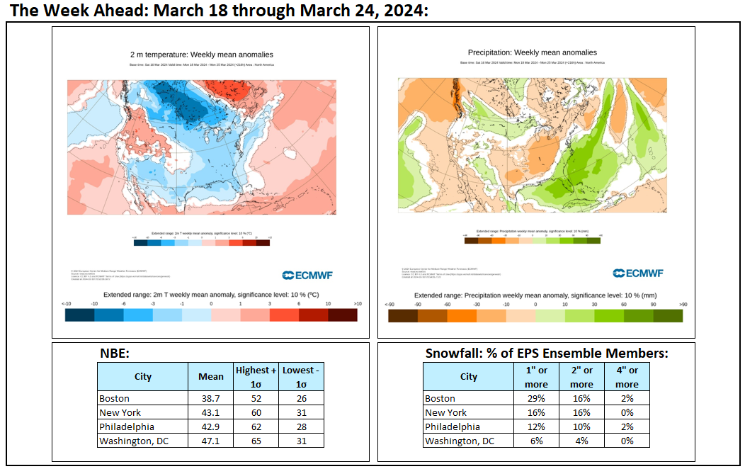
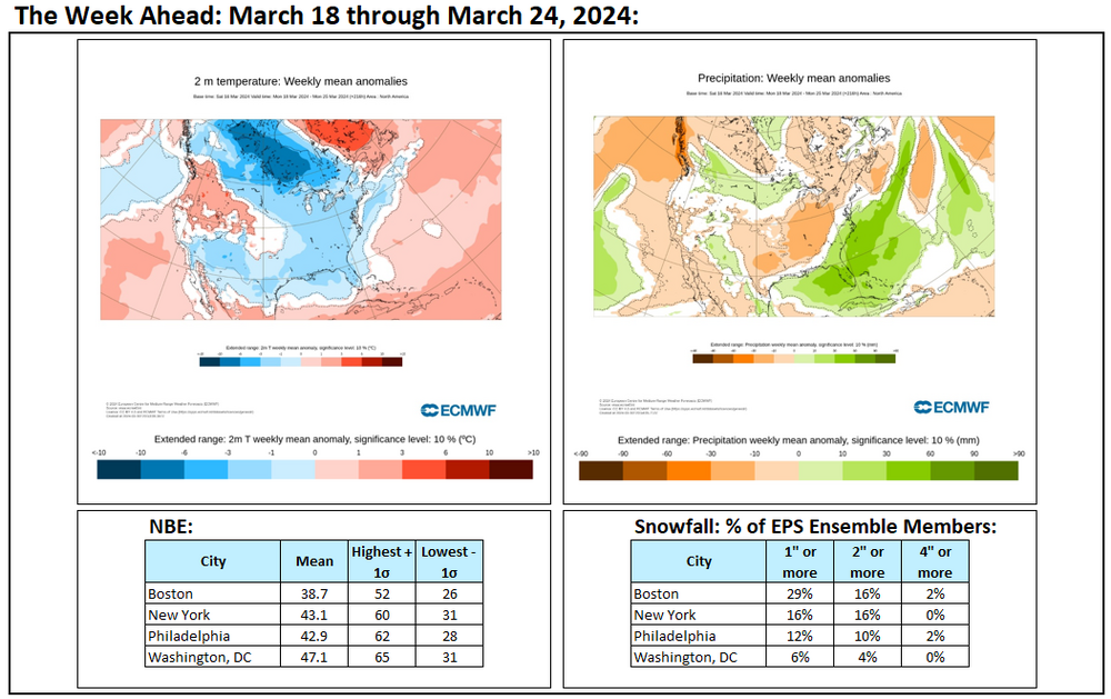
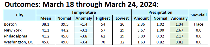
March 18-24, 2024 was generally cool and very wet in the Middle Atlantic and Southern New England areas.
-
This morning the temperature fell to 31° in New York City. It is possible that this morning will wind up becoming New York City's last freeze of the 2023-24 season. The normal last freeze occurs on March 29th. Moderation lies ahead, even as additional rain is likely late in the week. The closing days of March could turn warmer with widespread readings in the upper 50s. It is very likely that New York City's Central Park will finish the 2023-2024 snow season with less than 10" of seasonal snowfall for a record second consecutive season. Records go back to 1869. The ENSO Region 1+2 anomaly was +0.4°C and the Region 3.4 anomaly was +1.1°C for the week centered around March 13. For the past six weeks, the ENSO Region 1+2 anomaly has averaged +0.88°C and the ENSO Region 3.4 anomaly has averaged +1.42°C. The ongoing basinwide El Niño event is now fading. Neutral conditions could develop during the spring. The SOI was -0.43 today. The preliminary Arctic Oscillation (AO) was +0.282 today. Based on sensitivity analysis applied to the latest guidance, there is an implied near 100% probability that New York City will have a warmer than normal March (1991-2020 normal). March will likely finish with a mean temperature near 48.0° (5.3° above normal).
-
Recent freezes and yesterday's massive rainstorm decimated the early Magnolia blossoms, stripped the Japanese Apricot trees of all their blossoms, and brought down many of the early cherry blossoms at the New York Botanical Garden. Nevertheless, nature continues to advance deeper into spring. The variety and number of blossoms continues to increase.


-
The normal last freeze in New York City is March 29th. Today or tomorrow could be the last freeze of the season if the current guidance holds up.
-
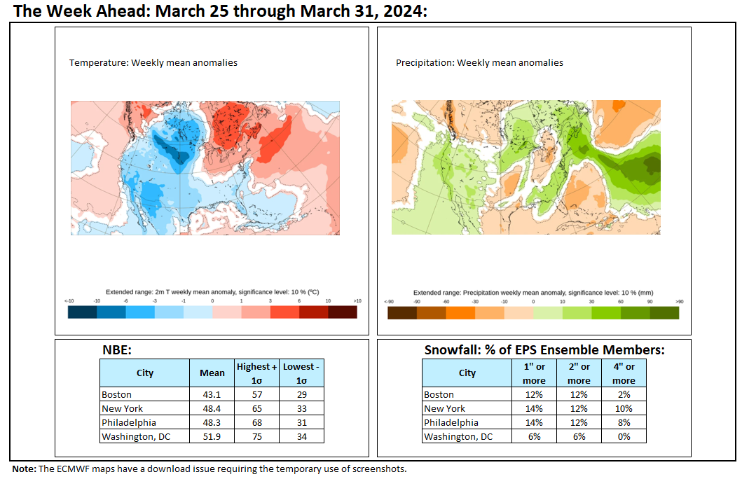
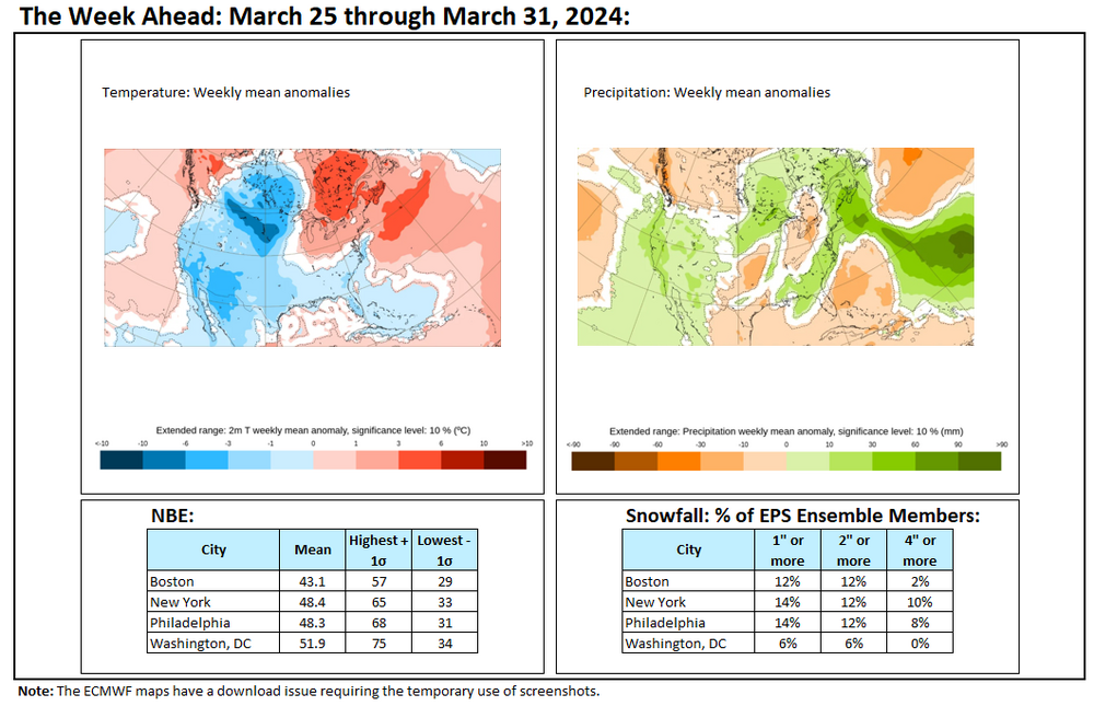
Week ahead numbers. With snowfall prospects diminishing, these will be the last such numbers until next winter.
-
Yes. Coldest has not.
-
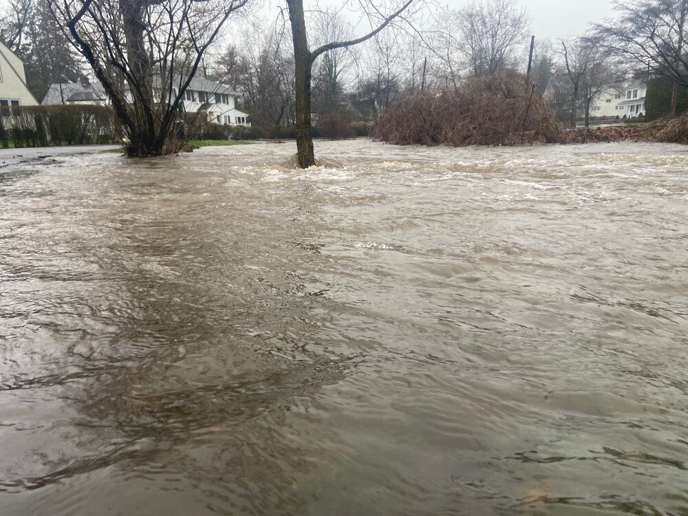
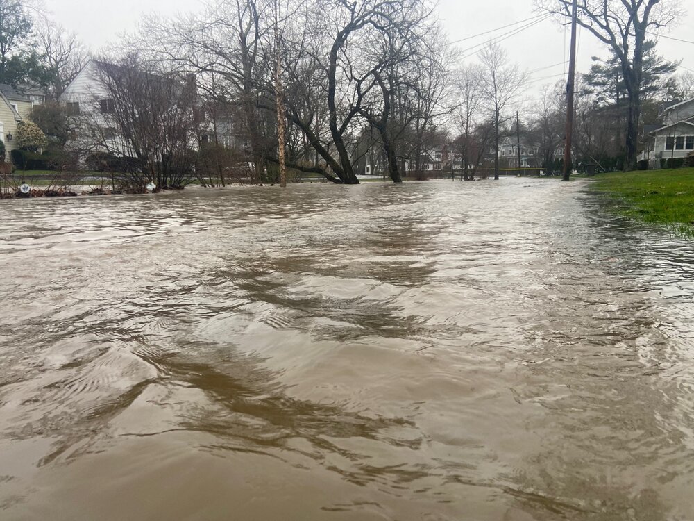
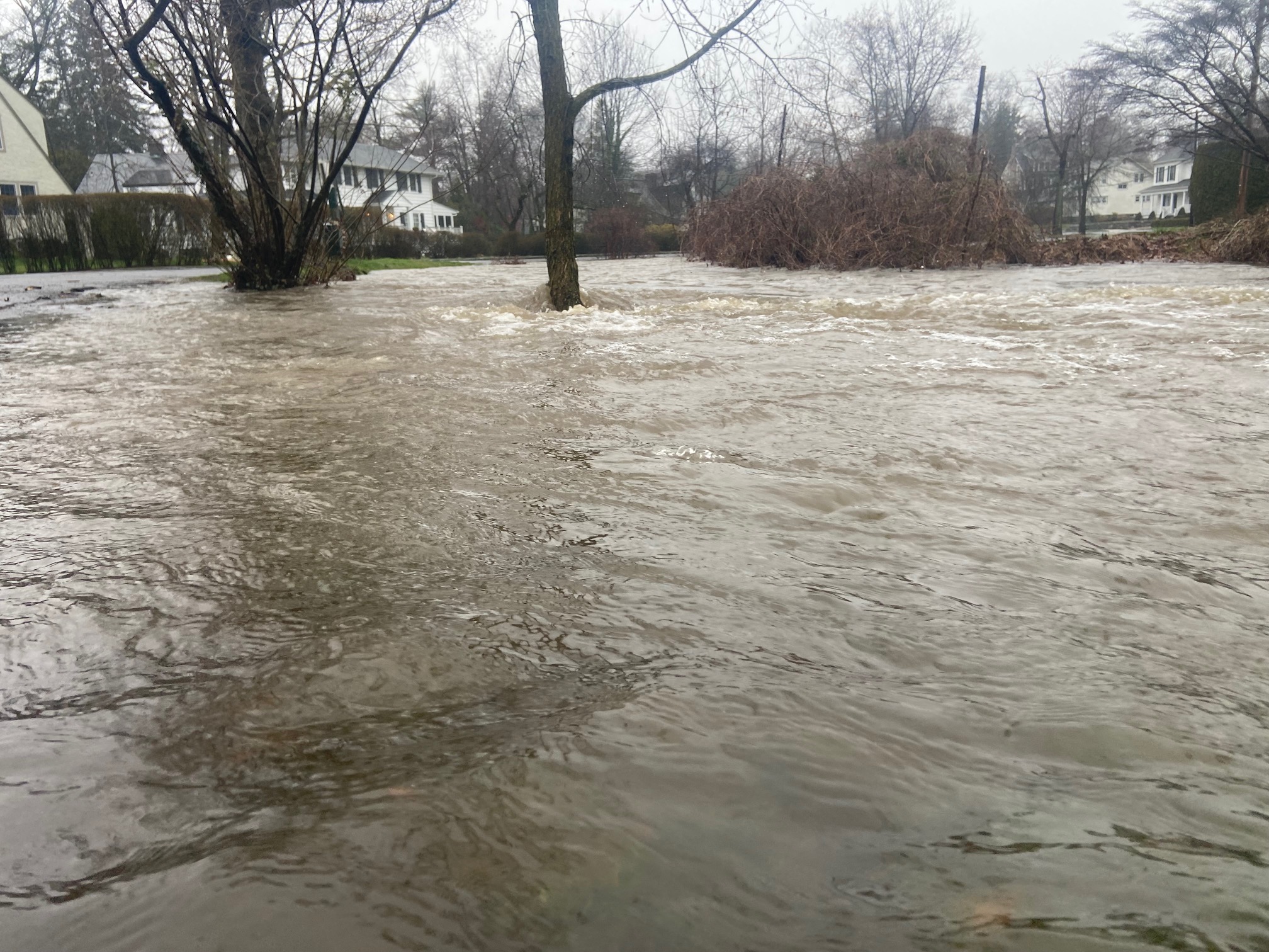
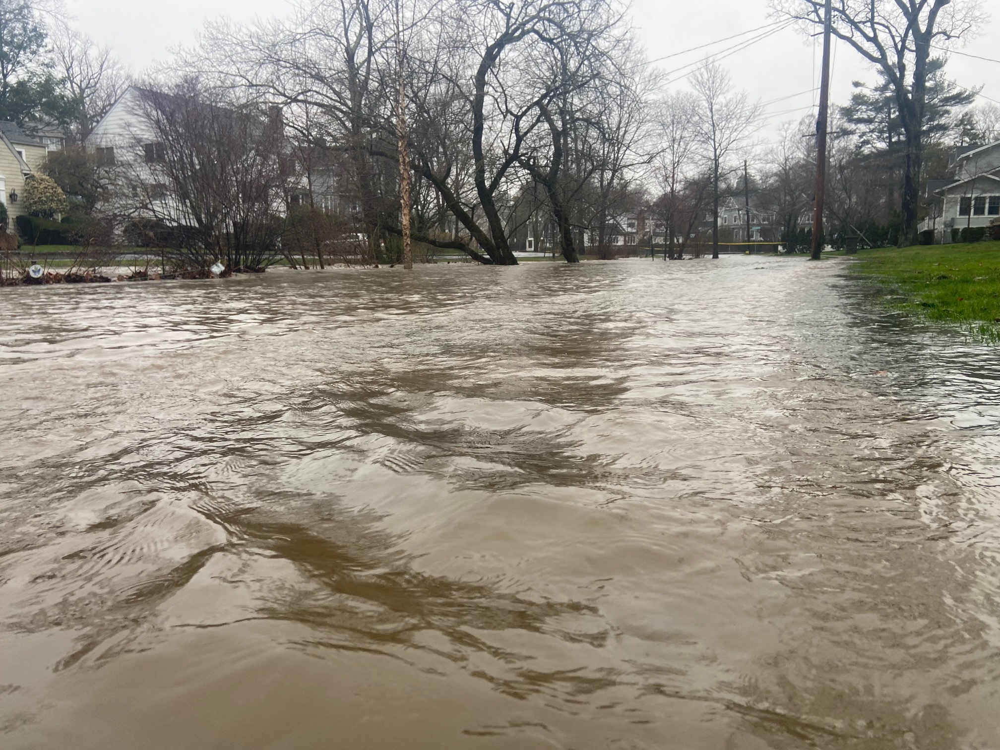
Today’s heavy rain produced flooding.