donsutherland1
-
Posts
23,765 -
Joined
Content Type
Profiles
Blogs
Forums
American Weather
Media Demo
Store
Gallery
Everything posted by donsutherland1
-
Following the heavy rain that started the day, the clouds broke and it turned noticeably warmer in the afternoon. It will turn even hotter tomorrow. Early next week will likely be very hot and humid. Widespread 95°-100° high temperatures are likely Monday through Wednesday. Cooler air will arrive late in the week. In parts of California, Nevada, and Arizona, a severe long-duration and dangerous heatwave continued to recede. The latest summer guidance continues to suggest a warmer to much warmer than normal summer lies ahead. The ENSO Region 1+2 anomaly was 0.0°C and the Region 3.4 anomaly was 0.3°C for the week centered around July 3. For the past six weeks, the ENSO Region 1+2 anomaly has averaged -0.62°C and the ENSO Region 3.4 anomaly has averaged +0.20°C. Neutral ENSO conditions will likely evolve into a La Niña event during the late summer or early fall. The SOI was -2.77 today. The preliminary Arctic Oscillation (AO) was +0.261 today. Based on sensitivity analysis applied to the latest guidance, there is an implied near 80% probability that New York City will have a warmer than normal July (1991-2020 normal). July will likely finish with a mean temperature near 79.9° (2.4° above normal). That would rank 2024 as the 10th hottest July on record.
-
As of 9:10 am, New Haven has picked up 1.27” of rain. That breaks its daily record of 1.03” from 1975. New York City has seen 1.89”. Parts of the Mount Holly forecast area have seen 7” since yesterday.
-
Rain and thunderstorms are likely into tomorrow. A general storm total 0.50"-1.50" rainfall with locally higher amounts is likely by the time the rain ends tomorrow afternoon. Through 8 pm, Georgetown, DE has picked up 3.76" of rain. That broke that city's daily mark of 3.41" from 2013. Heat will begin to return during on Sunday. Early next week will likely be very hot and humid. The heat will likely crest during Monday through Wednesday. During that time, widespread 95°-100° high temperatures are possible. Cooler air will arrive late in the week. In parts of California, Nevada, and Arizona, a severe long-duration and dangerous heatwave continues. Las Vegas recorded its record 7th consecutive 115° day. Boise saw the temperature reach 105° for a record-tying fourth consecutive day. The intense heat will finally recede over the next few days. The latest summer guidance continues to suggest a warmer to much warmer than normal summer lies ahead. The ENSO Region 1+2 anomaly was 0.0°C and the Region 3.4 anomaly was 0.3°C for the week centered around July 3. For the past six weeks, the ENSO Region 1+2 anomaly has averaged -0.62°C and the ENSO Region 3.4 anomaly has averaged +0.20°C. Neutral ENSO conditions will likely evolve into a La Niña event during the late summer or early fall. The SOI was -22.04 today. The preliminary Arctic Oscillation (AO) was +0.206 today. Based on sensitivity analysis applied to the latest guidance, there is an implied near 79% probability that New York City will have a warmer than normal July (1991-2020 normal). July will likely finish with a mean temperature near 79.9° (2.4° above normal). That would rank 2024 as the 10th hottest July on record.
-
Some showers or thundershowers are possible tomorrow into Saturday. Some of the rain could be heavy. A general 0.50"-1.50" rainfall is possible. It will turn slightly cooler before heat begins to return during the weekend. The beginning of next week could be hot and humid. In parts of California, Nevada, and Arizona, a severe long-duration and dangerous heatwave continues. Las Vegas topped out at 118°, its third highest figure on record. Las Vegas also reached 115° or above for a record sixth consecutive day. Milford, UT reached an all-time record 108°. The latest summer guidance continues to suggest a warmer to much warmer than normal summer lies ahead. The ENSO Region 1+2 anomaly was 0.0°C and the Region 3.4 anomaly was 0.3°C for the week centered around July 3. For the past six weeks, the ENSO Region 1+2 anomaly has averaged -0.62°C and the ENSO Region 3.4 anomaly has averaged +0.20°C. Neutral ENSO conditions will likely evolve into a La Niña event during the late summer or early fall. The SOI was -31.46 today. The preliminary Arctic Oscillation (AO) was -0.069 today. Based on sensitivity analysis applied to the latest guidance, there is an implied near 78% probability that New York City will have a warmer than normal July (1991-2020 normal). July will likely finish with a mean temperature near 79.9° (2.4° above normal). That would rank 2024 as the 10th hottest July on record.
-
Some showers or thundershowers are possible tomorrow. It will turn slightly cooler before heat begins to return during the weekend. The beginning of next week could be hot and humid. In parts of California, Nevada, and Arizona, a severe long-duration and dangerous heatwave continues. Las Vegas topped out at 118°, its third highest figure on record. Las Vegas also reached 115° or above for a record fifth consecutive day. Needles reached 122°. The latest summer guidance continues to suggest a warmer to much warmer than normal summer lies ahead. The ENSO Region 1+2 anomaly was 0.0°C and the Region 3.4 anomaly was 0.3°C for the week centered around July 3. For the past six weeks, the ENSO Region 1+2 anomaly has averaged -0.62°C and the ENSO Region 3.4 anomaly has averaged +0.20°C. Neutral ENSO conditions will likely evolve into a La Niña event during the late summer or early fall. The SOI was -15.70 today. The preliminary Arctic Oscillation (AO) was -0.321 today. Based on sensitivity analysis applied to the latest guidance, there is an implied near 78% probability that New York City will have a warmer than normal July (1991-2020 normal). July will likely finish with a mean temperature near 79.9° (2.4° above normal).
-
Very warm and humid weather will prevail through tomorrow. Some showers or thundershowers are possible. The latter part of the week could turn slightly cooler. In parts of California, Nevada, and Arizona, a severe long-duration and dangerous heatwave continues. Daggett reached 118°, tying its all-time mark for the third consecutive day. Las Vegas topped out at 119°, its second highest figure on record. Needles reached 122°. Severe heat appears unlikely in the East during at least the first half of July. The latest summer guidance continues to suggest a warmer to much warmer than normal summer lies ahead. The ENSO Region 1+2 anomaly was 0.0°C and the Region 3.4 anomaly was 0.3°C for the week centered around July 3. For the past six weeks, the ENSO Region 1+2 anomaly has averaged -0.62°C and the ENSO Region 3.4 anomaly has averaged +0.20°C. Neutral ENSO conditions will likely evolve into a La Niña event during the late summer or early fall. The SOI was +4.68 today. The preliminary Arctic Oscillation (AO) was -0.084 today. Based on sensitivity analysis applied to the latest guidance, there is an implied near 77% probability that New York City will have a warmer than normal July (1991-2020 normal). July will likely finish with a mean temperature near 79.8° (2.3° above normal).
-
Hot weather prevailed yet again today. High temperatures included: Baltimore: 98° New York City: 95° Newark: 94° Philadelphia: 95° Washington, DC: 98° The very warm and humid weather will prevail inro the middle of the week with temperatures generally running several degrees above normal. Some showers or thundershowers are possible. The latter part of the week could turn slightly cooler. In parts of California, Nevada, and Arizona, a severe long-duration and dangerous heatwave continues. Daggett, CA tied its all-time record of 118° for a second consecutive day. Redding recorded its record 4th consecutive 115° day. Blythe (120°), Death Valley (126°), Needles (123°), and Palm Springs (122°) all reached or exceeded 120°. Severe heat appears unlikely in the East during at least the first half of July. The latest summer guidance continues to suggest a warmer to much warmer than normal summer lies ahead. The ENSO Region 1+2 anomaly was 0.0°C and the Region 3.4 anomaly was 0.3°C for the week centered around July 3. For the past six weeks, the ENSO Region 1+2 anomaly has averaged -0.62°C and the ENSO Region 3.4 anomaly has averaged +0.20°C. Neutral ENSO conditions will likely evolve into a La Niña event during the late summer or early fall. The SOI was +4.31 today. The preliminary Arctic Oscillation (AO) was +0.250 today. Based on sensitivity analysis applied to the latest guidance, there is an implied near 73% probability that New York City will have a warmer than normal July (1991-2020 normal). July will likely finish with a mean temperature near 79.6° (2.1° above normal).
-
The temperature again rose into the 90s in parts of the Middle Atlantic region. High temperatures included: Baltimore: 97° New York City: 93° Newark: 94° Philadelphia: 95° Washington, DC: 97° The very warm and humid weather will prevail inro the middle of the week with temperatures generally running several degrees above normal. The latter part of the week could turn slightly cooler. In parts of California, Nevada, and Arizona, a severe long-duration and dangerous heatwave continues. Redding, CA tied its record of three consecutive 115° or above days following yesterday's all-time high of 119°. Las Vegas decimated its all-time record of 117° with a high of 120°. Daggett, CA tied its all-time mark of 118°. Twentynine Palms also tied its all-time mark of 118°. Death Valley topped out at 129°. Severe heat appears unlikely in the East during at least the first half of July. The latest summer guidance continues to suggest a warmer to much warmer than normal summer lies ahead. The ENSO Region 1+2 anomaly was -0.6°C and the Region 3.4 anomaly was 0.4°C for the week centered around June 26. For the past six weeks, the ENSO Region 1+2 anomaly has averaged -0.80°C and the ENSO Region 3.4 anomaly has averaged +0.18°C. Neutral ENSO conditions will likely evolve into a La Niña event during the late summer or early fall. The SOI was +4.99 today. The preliminary Arctic Oscillation (AO) was +0.429 today. Based on sensitivity analysis applied to the latest guidance, there is an implied near 70% probability that New York City will have a warmer than normal July (1991-2020 normal). July will likely finish with a mean temperature near 79.5° (2.0° above normal).
-
Today was another hot day in the Mid-Atlantic region. High temperatures included: Baltimore: 100° New York City: 92° Newark: 93° Philadelphia: 97° Raleigh: 102° (tied record set in 1999 and tied in 2022) Richmond: 99° Washington, DC: 98° The very warm and humid weather will prevail inro at least early next week with temperatures generally running several degrees above normal. In parts of California, Nevada, and Arizona, a severe long-duration and dangerous heatwave continues. As of 3 pm PDT, Redding, CA had reached 118°, which tied its all-time record. Severe heat appears unlikely in the East during at least the first half of July. The latest summer guidance continues to suggest a warmer to much warmer than normal summer lies ahead. The ENSO Region 1+2 anomaly was -0.6°C and the Region 3.4 anomaly was 0.4°C for the week centered around June 26. For the past six weeks, the ENSO Region 1+2 anomaly has averaged -0.80°C and the ENSO Region 3.4 anomaly has averaged +0.18°C. Neutral ENSO conditions will likely evolve into a La Niña event during the late summer or early fall. The SOI was +1.78 today. The preliminary Arctic Oscillation (AO) was +0.704 today.
-
Under variably cloudy skies, the temperature rose to 90° in New York City and 91° in Newark. Farther south, near record and record heat occurred. High temperatures included: Baltimore: 98° Charlotte: 101° (old record: 100°, 1954 and 2012) Norfolk: 97° Philadelphia: 95° Raleigh: 106° (old record: 102°, 1999) ***New all-time record*** Richmond: 99° Sterling, VA: 98° Washington, DC: 98° Following showers and thundershowers tonight, tomorrow will be another very warm and humid day. Showers and thunderstorms are likely tomorrow into Sunday. Some of the thunderstorms could bring strong winds and heavy downpours. The warm and humid weather will prevail inro at least early next week with temperatures generally running several degrees above normal. In parts of California, Nevada, and Arizona, a severe long-duration and dangerous heatwave continues. The heat is now spreading into the Pacific Northwest. Palm Springs saw the mercury reach an all-time record-breaking 124°. Blythe reached a July record-tying 123°. Needles hit a daily record 122°. Severe heat appears unlikely in the East during at least the first half of July. The latest summer guidance continues to suggest a warmer to much warmer than normal summer lies ahead. The ENSO Region 1+2 anomaly was -0.6°C and the Region 3.4 anomaly was 0.4°C for the week centered around June 26. For the past six weeks, the ENSO Region 1+2 anomaly has averaged -0.80°C and the ENSO Region 3.4 anomaly has averaged +0.18°C. Neutral ENSO conditions will likely evolve into a La Niña event during the late summer or early fall. The SOI was +2.46 today. The preliminary Arctic Oscillation (AO) was +0.621 today.
-
Occasional Thoughts on Climate Change
donsutherland1 replied to donsutherland1's topic in Climate Change
Typo: 3 feet not 3 meters. -
Occasional Thoughts on Climate Change
donsutherland1 replied to donsutherland1's topic in Climate Change
Today, Martz is actually complaining about headlines related to California's extreme heatwave. He posted irrelevant and cherry picked data for 105F highs at select unspecified stations to criticize the headlines. In fact, several locations could see all-time high temperature records, their longest 110F or 120F stretches on record, etc. The NWS, private sector meteorologists, and news media are all covering the extreme heat to help protect human health and lives. Martz's criticism undermines that effort with its deflection to irrelevant information. Also, most of his 10 questions are red herrings. One contains a made-up figure for possible U.S. expenditures on decarbonization. Another ignores the subsidies for fossil fuels that remain magnitudes of order above those for clean energy. His questions are raised in bad faith. -
Occasional Thoughts on Climate Change
donsutherland1 replied to donsutherland1's topic in Climate Change
The questions reveal one that is grossly ill-informed about anthropogenic climate change, climate science literature and discussions, attribution studies, and fiscal policy. The questions are aimed not to gather useful information, but to deflect attention from climate change and silence discussions related to it. They are not good faith inquiries. ➊ To the nearest tenth of a degree Celsius, what is the “correct” global mean surface temperature (GMST)? The question is a common “red herring” aimed at deflecting attention from the rate and magnitude of warming that has occurred since pre-industrial times and the expected warming that will occur from a continued burning of fossil fuels. ➋ What does a “perfect” climate look like? If so, when did we have one and what was it like? Usually, activists will say “pre-industrial.” But, why? Pre-industrial is the starting point selected, as it largely predates the dramatic increase in greenhouse gas emissions that has occurred since then. Talk about a “perfect” climate is another “red herring” aimed at evading what is actually occurring. ➌ What is the “correct” amount of bad weather? How many tropical cyclones, tornadoes, thunderstorms, hailstorms, droughts, floods, heatwaves, cold waves and wildfires should there be per year globally? Please provide exact numbers and then explain why. The question is another common “red herring.” Climate change is driving an increase in heatwaves (frequency, duration, and magnitude), extreme precipitation events, flash droughts, and wildfires in some regions. It is also reducing the frequency of extreme cold outbreaks. It is also leading to an increase in intense (Category 3-5) Atlantic basin hurricanes. ➍ Why do you think temperature departures from the 1850 climatic baseline mean is the sole metric which determines human welfare? Why would the climate of the Little Ice Age be preferable than today's climate? What was better about the climate in 1850 than that of 2024? Is today's climate too dangerous? If so, why? Provide data and evidence to support your reasoning. The climate baseline is used to assess the change in temperature that has occurred since the pre-industrial age due to anthropogenic climate change. It is not and never has been used by climate scientists to make broader claims about human welfare. ➎ What is the “correct” atmospheric carbon dioxide level? What dry-air volume or a range of atmospheric carbon dioxide concentrations would be optimal for plant growth? Show me data and explain why. The question is another “red herring.” Climate scientists reference the relatively stable pre-industrial level of CO2 (roughly 280 PPM). They also assess climate sensitivity for a doubling of CO2. They do not make claims about a “correct” figure. ➏ The Inflation Reduction Act (IRA) was popularized as the biggest piece of climate legislation in history. But, since it was signed into law, climate activists say climate change has only gotten worse. Why? The Inflation Reduction Act, by itself, provided incentives for the use of cleaner energy sources. It contained no binding provisions for the reduction in fossil fuel production and consumption. Fossil fuel production and consumption has also continued to increase, even as clean energy usage has also increased due to the overall increase in global energy demand. As long as greenhouse gas emissions are net positive, additional warming will occur. Some climate scientists such as James Hansen believe that even when net zero is reached, there will be additional warming for some time. ➐ Trillions of taxpayer dollars have been spent on so-called “climate action” over the past 35-years. When will that give us that perfect climate, and when it does how will we know? What measure? The IMF has estimated that annual global subsidies (direct and indirect) for fossil fuels now amounts to $7 trillion globally. ➑ If the U.S. spends hundreds of trillions of dollars to decarbonize our economy to achieve “net zero” by the year 2050, then how much will it reduce GMST by the year 2100, assuming the climate models are accurate? Please round your answer to the nearest tenth of a degree Celsius and show your math! There is no evidence, budget projections, or proposals related to the U.S. spending “hundreds of trillions of dollars” on decarbonization. This is an invented figure that has no basis in reality. Projections can be made based on the greenhouse gas emissions and IPCC has offered a range of scenarios. Projections are not run for concocted make-believe scenarios. ➒ If you can't provide me with an answer to question eight, then here's my follow-up: If you don't know how much net zero emissions in the U.S. would reduce GMST by 2100, are we supposed to just spend all that money and see what happens? Question 8 has no basis in reality. No such proposals exist. If the author of the post says they do, he should provide a link or links to the appropriate documentation. Nothing like that is found in a search of CBO and OMB, projections. Ongoing modest efforts fall far short of the threshold cited by the author. ➊⓿ Why do efforts to mitigate exclusively center on reducing carbon emissions, and ignore more effective strategies such as building weather-resilient infrastructure and enforcing stricter zoning codes? Addressing climate change requires mitigation and resilience. Mitigation is required to address the principal drivers of anthropogenic climate change (greenhouse gas emissions). Resilience is needed to adapt to the realities of the evolving climate. Without mitigation, today’s resilience initiatives will “buy” only a little time in the short-term, but will be largely ineffectual e.g., planned increases in street levels in Miami would be useless against a potential 3-meter or more increase in sea levels by 2100. -
Occasional Thoughts on Climate Change
donsutherland1 replied to donsutherland1's topic in Climate Change
Yes. The highest reliable temperature there and globally is 130F. -
Occasional Thoughts on Climate Change
donsutherland1 replied to donsutherland1's topic in Climate Change
I agree. Even worse, that incorrect reading is recognized as the state record. -
It will turn somewhat warmer and more humid starting tomorrow. Through the weekend, a shower or thundershower is possible on each day, although the greatest risk for widespread thunderstorm activity exists for Saturday into Sunday. Overall, the month looks to be warmer to much warmer than normal. In parts of California, Nevada, and Arizona, a severe long-duration and dangerous heatwave is now getting underway. The heat could spread into the Pacific Northwest this weekend with the temperature soaring into the lower 100s in Portland. Fresno and Redding could approach or reach their records for most consecutive 110° days. Reno reach or exceed its record for most consecutive 105° days. So far, such severe heat appears unlikely in the East during at least the first half of July. The latest summer guidance continues to suggest a warmer to much warmer than normal summer lies ahead. The ENSO Region 1+2 anomaly was -0.6°C and the Region 3.4 anomaly was 0.4°C for the week centered around June 26. For the past six weeks, the ENSO Region 1+2 anomaly has averaged -0.80°C and the ENSO Region 3.4 anomaly has averaged +0.18°C. Neutral ENSO conditions will likely evolve into a La Niña event during the late summer or early fall. The SOI was +12.68 today. The preliminary Arctic Oscillation (AO) was +2.080 today.
-
Occasional Thoughts on Climate Change
donsutherland1 replied to donsutherland1's topic in Climate Change
It’s only working on my phone. -
Tomorrow will be another pleasant day with abundant sunshine and fairly low humidity. Afterward, it will turn warmer. Overall, the month looks to be warmer to much warmer than normal. In parts of California, Nevada, and Arizona, a severe long-duration heatwave will develop this week. The heat could spread into the Pacific Northwest this weekend with the temperature soaring into the upper 90s to perhaps 100° in Portland. Fresno and Redding could approach or reach their records for most consecutive 110° days. So far, such severe heat appears unlikely in the East during at least the first third of July. The latest summer guidance continues to suggest a warmer to much warmer than normal summer lies ahead. The ENSO Region 1+2 anomaly was -0.6°C and the Region 3.4 anomaly was 0.4°C for the week centered around June 26. For the past six weeks, the ENSO Region 1+2 anomaly has averaged -0.80°C and the ENSO Region 3.4 anomaly has averaged +0.18°C. Neutral ENSO conditions will likely evolve into a La Niña event during the late summer or early fall. The SOI was +16.19 today. The preliminary Arctic Oscillation (AO) was +2.519 today.
-
160 mph. Cat.5.
-
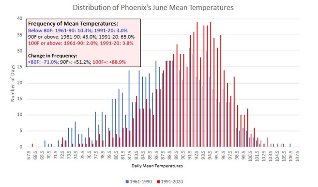
Phoenix Experiences its Hottest June on Record
donsutherland1 replied to donsutherland1's topic in Climate Change
No. Early evidence suggests that specific humidity has actually fallen in the U.S. Southwest: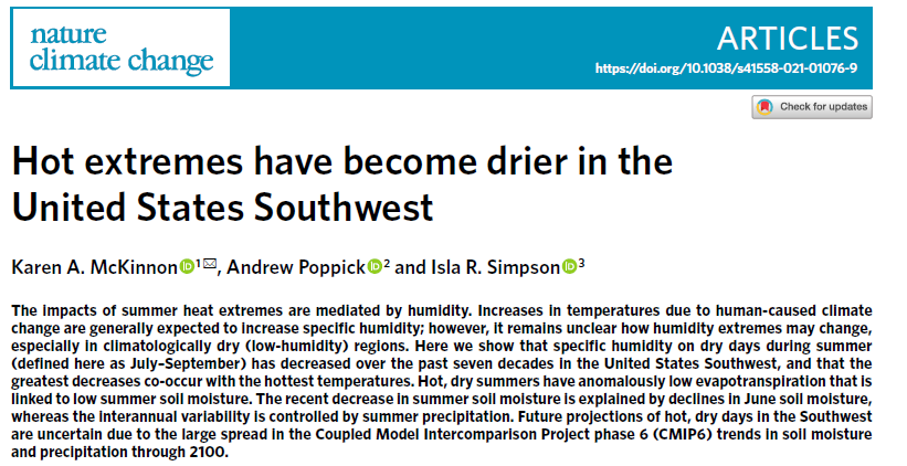
-
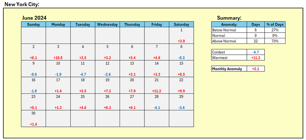
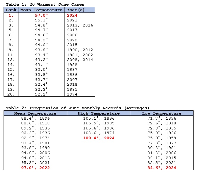
NYC's June temperature summary:
-
Tomorrow and Wednesday will be pleasant days with abundant sunshine, low humidity, and a refreshing breeze. Afterward, it will turn warmer. Overall, the month looks to be warmer to much warmer than normal. In parts of California, Nevada, and Arizona, a severe long-duration heatwave will develop this week. The heat could spread into the Pacific Northwest this weekend with the temperature soaring into the upper 90s to perhaps 100° in Portland. Fresno and Redding could approach or reach their records for most consecutive 110° days. So far, such severe heat appears unlikely in the East during at least the first third of July. The latest summer guidance continues to suggest a warmer to much warmer than normal summer lies ahead. The ENSO Region 1+2 anomaly was -0.9°C and the Region 3.4 anomaly was 0.3°C for the week centered around June 19. For the past six weeks, the ENSO Region 1+2 anomaly has averaged -0.88°C and the ENSO Region 3.4 anomaly has averaged +0.15°C. Neutral ENSO conditions will likely evolve into a La Niña event during the late summer or early fall. The SOI was +19.57 today. The preliminary Arctic Oscillation (AO) was +2.320 today.
-
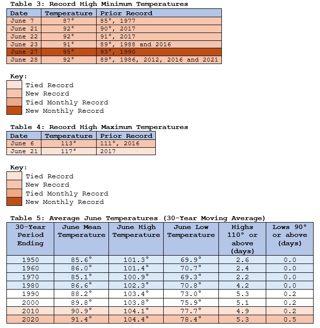
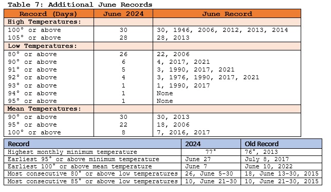
In an increasingly hot world driven by anthropogenic climate change, Phoenix experienced its hottest June on record with a monthly mean temperature of 97.0°. What was most noticeable this month was the duration of sustained high heat, as was the case during that city’s record 31-day stretch of 110° or above high temperatures last year. Anthropogenic climate change is driving a warming of Phoenix's summers. It is making hot patterns hotter. Hot nights are amplified by the Urban Heat Island (UHI) Effect. Climate change is also increasing the persistence of hot patterns through wave resonance events. The observed global warming since the 1950s is unequivocal with anthropogenic greenhouse gas emissions, largely from the burning of fossil fuels, being the dominant driver of that warming. Phoenix’s full-year records go back to 1896. The first summer to average 95.0° or above occurred in 2013 (95.1°). Summer 2015 matched the 2013 record. Summer 2020, which set a record for most 100° days (145) set a new benchmark at 96.7°. Three years later, that mark was incinerated by a 97.1° average summer temperature. Since 1980, Phoenix’s summers have been warming at a rate of 0.9° per decade. June is also warming rapidly. The monthly mean temperature has increased 3.2° from the 1961-1990 period to the 1991-2020 period. June 2006 was the first June to attain a mean temperature of 94.0° or above (94.6°). That mark was then broken in 2013 (94.8°) and 2021 (95.3°). The 2021 record was demolished this year. Since 2015, six of the ten Junes have had a monthly mean temperature of 94.0° or above. Put another way, June heat that was once extraordinary is now on a path toward becoming normal. Select Highlights: Updates: Phoenix's warming summers Phoenix Experiences its Hottest Summer on Record
-
June will be finishing with a monthly mean temperature of 75.2° in New York City. That will tie June 2024 with June 1994 as the third warmest June on record. Farther south, Baltimore recorded its 5th 96° or above high temperature this month. That ties the June record set in 1991 and tied in 2010 and 2012. July will then get off to a pleasant start. Temperatures could run somewhat below normal for the first three days before it turns warmer. Overall, the month looks to be warmer to much warmer than normal. The latest summer guidance continues to suggest a warmer to much warmer than normal summer lies ahead. The ENSO Region 1+2 anomaly was -0.9°C and the Region 3.4 anomaly was 0.3°C for the week centered around June 19. For the past six weeks, the ENSO Region 1+2 anomaly has averaged -0.88°C and the ENSO Region 3.4 anomaly has averaged +0.15°C. Neutral ENSO conditions will likely evolve into a La Niña event during the late summer or early fall. The SOI was +13.43 today. The preliminary Arctic Oscillation (AO) was +1.907 today.
-
Brief gusty thunderstorm: