Quincy
-
Posts
6,220 -
Joined
-
Last visited
Content Type
Profiles
Blogs
Forums
American Weather
Media Demo
Store
Gallery
Everything posted by Quincy
-
-
SPC has upgraded parts of Kansas and Oklahoma to an Enhanced Risk tomorrow. This includes a significant tornado delineation from south-central Kansas into central Oklahoma. The greatest risk for scattered to widespread severe thunderstorms appears to be across the western half of Kansas. A more isolated risk is anticipated farther south, but any storms that can initiate could be quite intense. Particularly across the western half of Oklahoma.
-
Day 1 Enhanced Risk from northeastern Colorado toward the CO/KS/NE border area. Driven by significant hail potential and 10% tornado risk via SPC. I tend to think the tornado risk may not be as apparent, at least not with westward extent across Colorado, but we’ll see. CAMs have not showed much of a consistent signal out that way and right now there’s high pressure and cloudiness lingering. My gut says northwestern Kansas has a somewhat better shot at tornadoes, given higher quality moisture, proximity to a frontal boundary (likely nudging north as a warm front later today). The caveat is that storm modes may be quite messy. Will follow up in a bit for tomorrow with the upcoming Day 2 Outlook from SPC.
-
Supercells galore, not only in Kansas, but Nebraska and even North Dakota at the moment.
-
Chased this and other elevated supercells on the SW flank of the Kansas MCS this afternoon:
-
Quick update: Added Friday to this thread, as parts of the region may be impacted by additional severe thunderstorms. Thursday has also trended a bit farther south, much of the severe threat may remain over Kansas.
-

May obs/discussion thread - Welcome to Severe Season!!
Quincy replied to weatherwiz's topic in New England
A GFS long range fantasy run the other day had snow showers down to Long Island. Long range ensemble guidance is in good agreement, with the caveat that it probably won’t snow. Several days of double digit negative temperature anomalies do seem probable later next week. -
It looks like a robust severe threat may evolve Wednesday and Thursday, focused on the Central Plains, as a trough ejects from the Four Corners region toward the central states. Given the forecast surface evolution, the favored region for severe activity focuses on northeastern Colorado and vicinity on Wednesday. Lee cyclogenesis, mesoscale forcing, upslope flow, sufficient destabilization and favorable wind fields suggest there may be a threat of large to very large hail and isolated tornadoes. As the surface low pivots toward South Dakota, additional severe storms are possible on Thursday around the north-central Plains. Isolated activity farther south along the dryline could also develop. It’s a few days out, so details are still TBD, but at this point it looks like a noteworthy setup. Considering the pattern turns ugly this weekend into next week, this may be one of the last bigger events until we get into late May.
-
A little surprised how narrow (N-S) the Tornado Watch is, but lines up with the latest HRRR helicity track map. 18z 3km NAM shows more development south, near and SE of a dryline bulge.
-
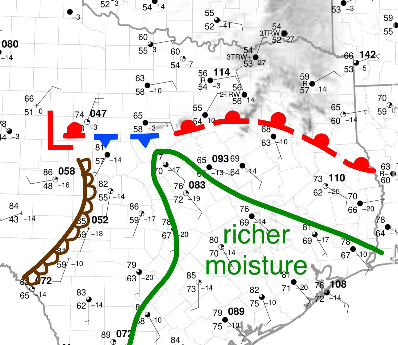
Mixed signals on today… On one hand, early day convection has chewed away at much of the thermodynamic environment across Oklahoma and effectively, points north. Relatively weak lapse rates, modest boundary layer moisture and limited air mass recovery is expected. With that said, an effective warm front is draped near or just south of the Red River. Lapse rates are steeper out in West Texas and trends suggest there will be moderate destabilization taking place in the Northwest Texas vicinity through the day. This combined with enhancement of upper level flow and backing of low level winds suggest there could be some supercell potential, possibly tornadic, this afternoon. I’d guess somewhere near the Red River. Central to South Texas looks like a more obviously favored area for severe and locally significant severe (very large hail).
-
Chasing the storm near Waco:
-
It’s well north of the boundary, which is also continuing to move south.
-
A sustained storm is developing near Abilene, but composite outflow/frontal boundary to the east continues to drift south. Better low level moisture remains displaced to the south and east, out toward Waco and into southeast Texas. Hail would appear to be the main threat in the short term. If any supercells develop in the warm sector, and/or storms closer to the surface low encounter better moisture, a more substantial tornado threat could be realized.
-
Severe Weather 4-19-23 through 4-21-23
Quincy replied to cheese007's topic in Central/Western States
Today was mostly a cap bust, aside from a couple storms near the Kansas/Nebraska border. Wednesday is a complex setup. That’s an understatement. Upper level troughing across the Rockies with several disturbances impinging on the central Plains during the second half of the day. Models are having issues with low pressure placement tomorrow, which will be rather important. In typical 2023 fashion, the NAM and HRRR are on opposite extreme ends of the spectrum. NAM is juiced and shows May-like moisture in central Kansas. The HRRR wildly mixes out. The truth will likely be in the middle. If moisture leans toward the more robust progs, you’d expect the triple point(s) to be the main focus for convective initiation. The southern Plains dryline may stay capped again, although moisture quality for Wednesday will be at least somewhat better than it was today. CAMs were much more aggressive last night into the 12z suite today. Most recent 00z CAMs are subdued with capping winning out, until near or after 00z Thursday. I’m not even going to pretend I have a confident forecast on this one. Going to sleep on it and see how observational trends look in the morning. -
Not too impressed by Friday 4/14. Current guidance suggests the dryline remains capped. The exception may be near the cold front, dryline, triple point vicinity. That’ll probably be up in Kansas or near the Kansas/Oklahoma border.
-
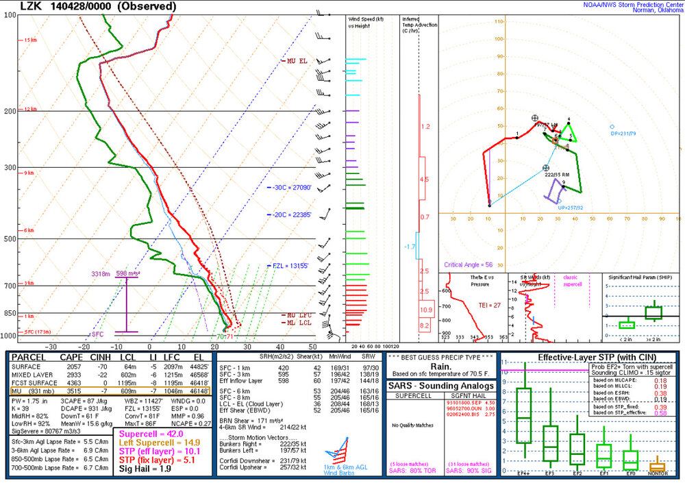
That was my first tornado. I did a terrible job trying to chase and document it, even though I was directly in front of it. With El Reno recently in mind and my inexperience, I bailed north(?!) at the last minute, thinking I’d be cutting it too close if I went southeast. I probably could have made it, but being new and extra cautious, I bailed. Knowing what I know now, I would have continued southeast another exit or two, instead of getting off in Mayflower. Then I would have probably gotten some incredible footage from the immediate southeast. To this day, the radar signature remains as the most impressive I’ve ever chased, let alone have been a couple of miles away from. It’s a great example of a warm front near the Arkansas River valley enhancing the channeling of low level flow. Always beware a warm front draped from NW/WNW to SE/ESE across central Arkansas. We’ve seen those setups produce prolific tornadoes before. The 00z LZK sounding is also one of the best sampled, regularly scheduled RAOBs you’ll ever see for a violent tornado, being in close proximity to the tornado in time and distance:
-
Chasing this currently. It’s elevated and the initial updraft is shriveling. It looked interesting for a bit:
-
-
Quick overview including 15z surface analysis. Can’t overlook the wildfire threat across the plains, but evening and overnight tornadoes will arguably be the most dangerous hazard.
-
Looking rather ominous between about 11 PM and maybe 5-6 AM. Just a terrible time for this sort of tornado threat.
-
Three main areas of concern: 1. Warm sector/near the warm front from Missouri toward the Iowa/Illinois border area. Pretty good model agreement that either a cluster or perhaps just a renegade storm or two initiates. A significant severe threat would likely accompany any storms, with large CAPE, supercell wind profiles and low level hodograph enlargement. 2. Dryline from eastern Kansas into Oklahoma. With slower trough ejection modeled, convective initiation seems unlikely. Should a storm manage to form, it would very likely be severe. I think this is the least likely of the three scenarios, especially if the model trend continues. 3. A more widespread severe threat may materialize after dark as the trough ejects and the low level jet ramps up. We could see a broken line of storms move across eastern Kansas, along with cellular warm sector activity possible across the Ozarks. The only thing perhaps limiting this threat is that the main line of storms may grow upscale due to nearly boundary-parallel shear and pre-frontal activity is a bit more uncertain.
-
I think most of us can agree that states in the South that are in the central time zone should be added here.
-
Strong synoptic signal, but not sure I’d be calling for a high risk this far out.
-
Due to mesoscale uncertainties, I understand not delineating a high risk at this time. Either way, a very broad area looks primed for tornadic supercells today.
-
Severe Weather 3-23-23 through 3-26-23
Quincy replied to cheese007's topic in Central/Western States
It’s also very close to the radar site, so we’re getting lower scans that we don’t often see with intense tornadoes. Undoubtedly EF-3+.