Quincy
-
Posts
6,220 -
Joined
-
Last visited
Content Type
Profiles
Blogs
Forums
American Weather
Media Demo
Store
Gallery
Everything posted by Quincy
-

Central/Southern Plains Severe Weather Palooza (4/29 - 05/05)
Quincy replied to Powerball's topic in Central/Western States
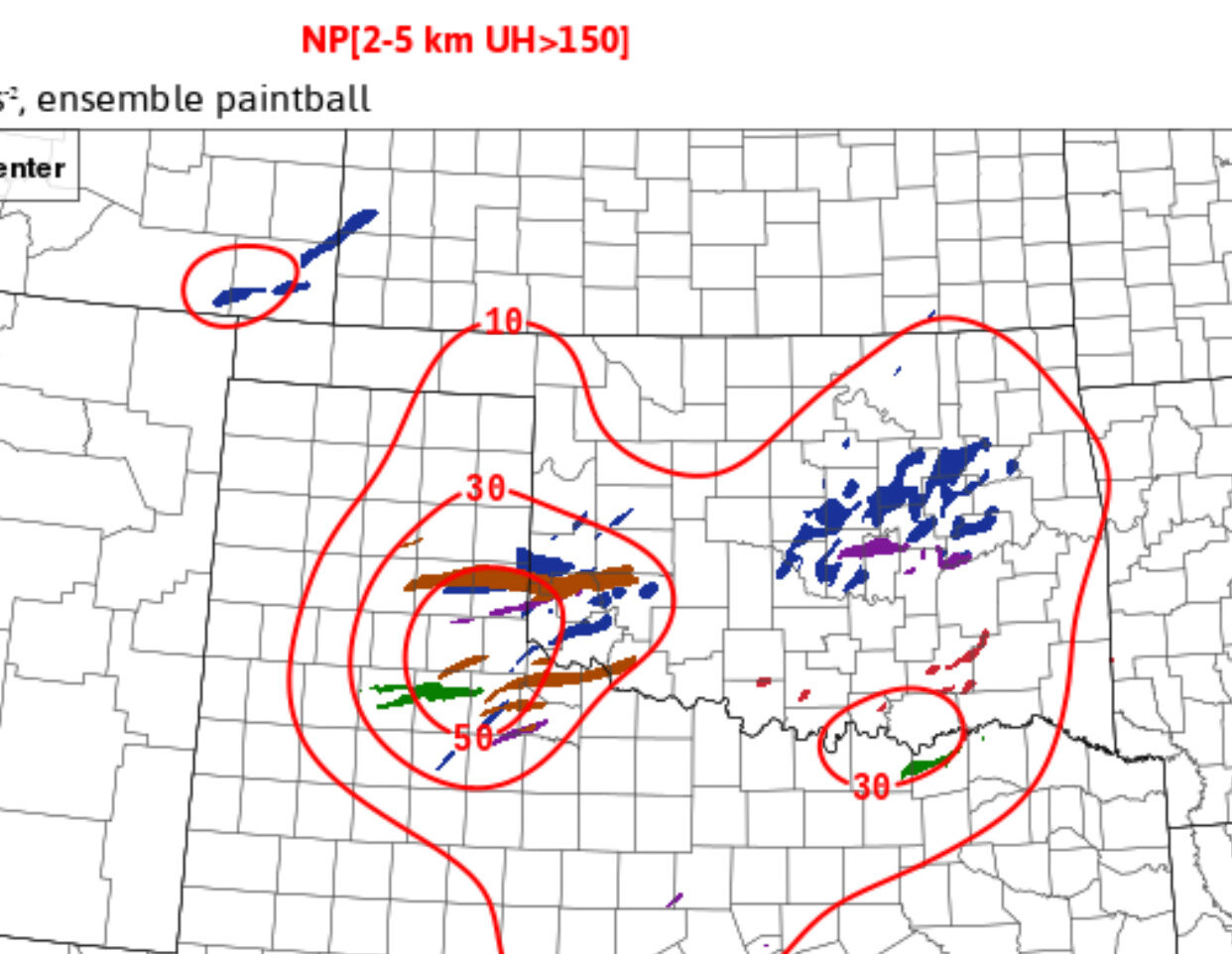
HREF ensemble probability for intense (>150 m2/s2) helicity tracks. Keep in mind these don’t explicitly/necessarily indicate tornado potential, but given low level moisture and wind fields today, there is a bona fide tornado threat. The cluster near/NE of OKC is mostly FV3 driven, but still plausible near the warm front, IF low level thermodynamic fields improve enough to support supercells rooted near the surface.
-
Central/Southern Plains Severe Weather Palooza (4/29 - 05/05)
Quincy replied to Powerball's topic in Central/Western States
It’s concerning that HRRR is not showing much of any convective initiation through mid-afternoon. Some elevated activity races north with the warm front, but it looks like the WF is going to be draped close to the I-40 corridor. Right now, low level lapse rates are pretty bad (< 5 C/km across all of Oklahoma) and capping will probably limit CI for a while. Not really sure how convection evolves, but any discrete/semi-discrete cells initiating after 3-4 PM will need to be watched very closely. Based on near term trends, those cells coming out of the panhandle later will probably remain at least semi-discrete as they move into southwestern Oklahoma. Looks like odds are increasing for at least 1-2 long-track, intense supercells, with other tornadic supercells possible in the warm sector and near the warm front. -
Central/Southern Plains Severe Weather Palooza (4/29 - 05/05)
Quincy replied to Powerball's topic in Central/Western States
Pretty classic localized outbreak setup unfolding, around the SE Texas panhandle/far NW Texas vicinity. Morning radar and water vapor imagery suggest little to no airmass disruption will evolve SW of a lifting warm front across NW Texas. High res model consensus shows deep shear vectors (~50 knots) just about perpendicular to the dryline. Point forecast soundings show a reservoir of 8-8.5 C/km mid-level lapse rates, favoring large to very large hail. Low level hodographs enlarge as early as 21z in the SE panhandle, as storms initiate. As I see it, the three main limiting factors from this being a higher end regional (vs localized) event are: 1. Convective overturning is still possible from western North Texas into SW Oklahoma, where warm air advection showers/storms could still blow up by early afternoon. This would limit how far east the significant tornado threat (associated with discrete/semi-discrete supercells) could extend into Oklahoma. 2. Storm mode near the triple point could get messy as storms interact with the warm front. Clustering and storm interactions might disrupt potential longevity of discrete storm modes. 3. Several models show discrete supercells firing farther south across West Texas ahead of the dryline, but here, hodographs are more straight and elongated, suggesting less of a tornado threat. While the epicenter may be near the SE Texas panhandle, look for isolated storms as far south as Southwest Texas, while mixed storm modes with embedded supercells will also be possible across North Texas and much of Oklahoma. -
Central/Southern Plains Severe Weather Palooza (4/29 - 05/05)
Quincy replied to Powerball's topic in Central/Western States
This setup reminds me a bit of 5/16/15 (Tipton/Elmer tornado). I remember that was a grungy HP setup. I started chasing in the Texas panhandle and then bailed east just in time for Tipton. I recall that the northern threat area (N of I-40) was convectively overturned and mostly a bust. There were nocturnal tornadoes into northeastern Oklahoma, which could happen again. Interestingly, CIPS analog data pegs 5/19/15 as the top analog, but 5/16/15 seems to fit the pattern a bit better. 5/16 has some differences, so I’m not saying that it’s a perfect match synoptically. HRRR seems to be on the higher end of the ceiling here. ARW also goes kinda bonkers with discrete/semi-discrete cells over a broad swath of the southern Plains. 3km NAM blows an MCS through NW Texas/southern OK in the morning, chewing away at most of the threat area. As a result, the NAM is on the lower end of the spectrum. Still a complicated setup, but I’d think that areas west (dryline) and south (tail end Charlie near FST?) have the greatest potential for at least semi-discrete storms. Oklahoma is a wildcard, but it could be more of a late show there. North Texas might even get in on the action, if early convection isn’t too disruptive. -
Central/Southern Plains Severe Weather Palooza (4/29 - 05/05)
Quincy replied to Powerball's topic in Central/Western States
The two major 18z CAMs show very different convective evolutions tomorrow: 3km NAM shows a morning MCS that effectively overturns the environment from much of northwest Texas into southwestern Oklahoma. Isolated cells by the dryline (near I-27) struggle to mature and blobby convection affects parts of North Texas into southern Oklahoma. HRRR shows minimal early day convection, resulting in a cluster of intense supercells forming off the dryline, near the Caprock, and moving east into southwestern Oklahoma. I think in this setup, I’d lead toward the messier convective evolution, but let’s see how trends lean tonight. -
Central/Southern Plains Severe Weather Palooza (4/29 - 05/05)
Quincy replied to Powerball's topic in Central/Western States
Today looks like a quieter day, but Texas could see a few isolated severe storms. Some CAMs show a supercell or two trying to form in East Texas, although deep layer shear looks marginal. Another area of focus would be the Edwards Plateau/Hill Country area. Isolated supercells seem likely over in Mexico, but a storm or two could form over or move onto the Texas side. Tomorrow could be much more active, although the effects of early day convection complicate the forecast. I’d tend to think that areas near and north of I-40 will probably be overturned and miss out on the strongest storms. There seems to be more confidence for isolated/scattered supercells in west/northwest Texas. Oklahoma is a wild card, but storm mode will probably be more messy, rather than discrete, in these parts. -
Central/Southern Plains Severe Weather Palooza (4/29 - 05/05)
Quincy replied to Powerball's topic in Central/Western States
Chased a supercell for almost two hours from SW of OKC to east of Norman. The sunset tonight back home in Moore really topped off a successful local storm chase.

-
Central/Southern Plains Severe Weather Palooza (4/29 - 05/05)
Quincy replied to Powerball's topic in Central/Western States
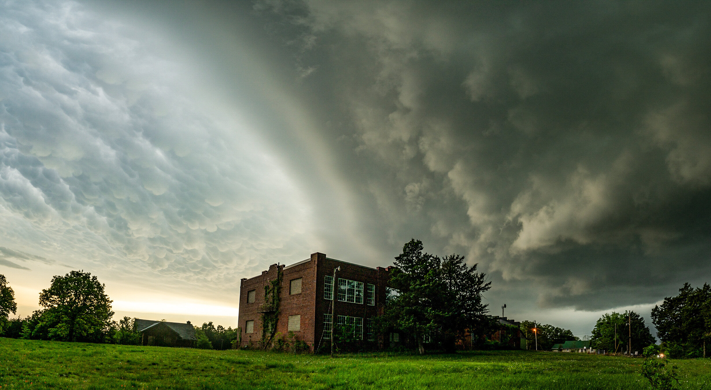
I couldn’t leave OKC until 4:30ish, so I took my chances with the supercell SW of the city. Neat structure and several photo opportunities: I may post a few more pictures after I can upload from the actual camera. -
Central/Southern Plains Severe Weather Palooza (4/29 - 05/05)
Quincy replied to Powerball's topic in Central/Western States
Just a few thoughts regarding tomorrow… Models have trended south with the warm front. It was central Kansas a few days ago, to southern Kansas earlier today. Now 00z CAMs place the warm front across northern Oklahoma between 21-00z. There’s strong model agreement that semi discrete storms or a cluster develop near the triple point and ride the warm front, now expected to be draped WNW to ESE across northern to east-central Oklahoma. My concern is that early day convection could possibly keep the effective warm front even farther south, possibly close to OKC. It probably won’t be quite that far south, but effects from morning convection, including outflow boundaries/intersections with the warm front will need to be watched. Down the dryline, most guidance does not convect. Point forecast soundings from the HRRR between OKC and Lawton seem to suggest CI is unlikely, given lower quality boundary layer moisture, as opposed to the 3km NAM. The latter shows a more volatile environment right down to the Red River, but this could be overdone, similar to how Friday was modeled. The most realistic scenario is in between. Bottom line, tomorrow looks similar to this past Friday, only shifted about 150 miles south. The significant severe threat could be pushed close to OKC, especially if early day convection keeps the warm front suppressed. Betting odds favor north-central OK at this point, with dryline initiation near/south of I-40 leaning toward unlikely. -
Central/Southern Plains Severe Weather Palooza (4/29 - 05/05)
Quincy replied to Powerball's topic in Central/Western States
That early day convection can throw several variables into the equation. Some favorable and others potentially unfavorable: Convection can leave outflow boundaries. Early day moisture could also help limit mixing, keeping LCLs a bit lower and a slightly more saturated boundary layer. Flip side, too much cloud cover could limit surface heating. If early convection is too robust, that could augment wind fields a bit. With that said, this does show a regional signal, where even morning convection could have little to no affect, as rapid recovery takes place in the afternoon. I compared this setup to last Friday and synoptically, it is very similar. Differences: Slightly faster. Convection seems likely by early afternoon in Kansas. The system is also a nudge farther south. 06z NAM was showing heights falling as far south as I-40 in Oklahoma by 18-21z. This should be a bit alarming. I also noticed less mid-level dry air and somewhat better moisture (think mean mixing ratios) through the column. -
Central/Southern Plains Severe Weather Palooza (4/29 - 05/05)
Quincy replied to Powerball's topic in Central/Western States
Prime example of a tail end Charlie storm going nuts right around sunset. Hope there weren’t any serious injuries. -
Central/Southern Plains Severe Weather Palooza (4/29 - 05/05)
Quincy replied to Powerball's topic in Central/Western States
Not sure I’ve ever seen this. Most guidance backed off of dryline storms in OK/southern KS until last minute, then brought them back. Only to lose them last minute as well. WoFS is looking pretty bad right now too. Almost all cu along the dryline is dissipating. One of the harder busts of my career, but it can be a learning experience. -
Central/Southern Plains Severe Weather Palooza (4/29 - 05/05)
Quincy replied to Powerball's topic in Central/Western States
Initial cells are struggling to mature. What a delicate situation. So much potential for one or two intense storms, but also the likelihood that a lot of areas don’t see anything at all. -
Central/Southern Plains Severe Weather Palooza (4/29 - 05/05)
Quincy replied to Powerball's topic in Central/Western States
HRRR is playing catch-up with surface moisture, as is often the case. Latest mesonet data shows widespread 65-66F dew points across central Oklahoma. Latest HRRR run tries to initiate a cell in north-central Oklahoma and I wouldn’t be surprised if future runs favor more intense convective development. My thoughts: Relatively high confidence of isolated supercells from central KS into north-central OK. Think a secondary area is favored for CI in southwestern Oklahoma, but still have questions about how intense/long lived any convection might be there. OKC isn’t out of the woods either. That 12z OUN sounding showed some thick CAPE profiles and steep lapse rates above the capping inversion. I won’t be able to update for a few more hours and by then, it’s almost game time. Stay safe today! -
Central/Southern Plains Severe Weather Palooza (4/29 - 05/05)
Quincy replied to Powerball's topic in Central/Western States
Analog guidance coupled with the trajectory of the nose of the upper jet would suggest better than 50/50 odds that a storm could form in south-central Kansas or possibly north-central Oklahoma. -
Central/Southern Plains Severe Weather Palooza (4/29 - 05/05)
Quincy replied to Powerball's topic in Central/Western States
NAM/ARW suite doesn’t convect, but also shows a lot of residual cloud cover in Oklahoma, limiting daytime heating. NSSL still tries to pop a storm in north-central Oklahoma, while most other guidance shows nada south of the KS/OK border. Morning satellite and obs will play a big role in pinning down tomorrow’s threat. -
Central/Southern Plains Severe Weather Palooza (4/29 - 05/05)
Quincy replied to Powerball's topic in Central/Western States
FWIW, in regards to tomorrow… 18z NSSL WRF backed off of convective initiation (CI) in Oklahoma tomorrow. Latest 21z SREF also dropped CI probabilities to about 20% along the dryline. 00z HRRR indicates that most convective inhibition (CINH) is eroded by 22z near the OKC metro area, but no storms initiate. This is thanks to 2m temperatures rising into the mid-80s, atop low to mid-60s dew points. It’s close… modify the forecast soundings for slightly greater boundary layer moisture (HRRR dry bias) and you’d probably get within 1-2F of reaching convective temperatures. Let’s see how the rest of the 00z suite looks. -
I remember that day well. There was an intense morning supercell up by I-70 that went nuts and led to some of the best early day elevated supercell structure in recent memory. My fate was similar to yours. I pulled some obs and data. Most of the activity was confined to near the warm front/thermal gradient. 18z DDC sounding didn’t show much capping at all. At first I thought maybe it had to do with a weakness in the winds around 500mb, but I’m not sure if that was a prominent factor. There were severe storms even farther south in the Texas panhandle, where large scale forcing was weaker and 500mb winds were even less favorable. https://www.spc.noaa.gov/exper/archive/event.php?date=20210526
-
FV3 has an over-convect bias and will almost always initiate in even the more borderline/marginal setups. With that said, it does look like a delicate and potentially explosive setup just east of the dryline tomorrow from central Oklahoma into central Kansas. Most CAMs show little to no convection, which does give more confidence that any development will probably be isolated. Given the orientation of the shortwave and wind fields, shear vectors are perpendicular to the dryline. Thermodynamic profiles are very favorable, with a capping inversion that should prevent convective initiation for most of the afternoon. (Diverging from earlier model runs that were erupting storms by 20-21z) The NSSL highlights an uncomfortable potential scenario, with one lone supercell forming over central Oklahoma late in the afternoon. Differing from some previous events, the warm sector looks thick enough to support any sustained storm for several hours, assuming that a storm can initiate. I still remain skeptical about CI with southward extent across Oklahoma, but it’s still plausible.
-
Took this photo just a short time before this radar collage. Chased the storm through the south side of OKC. Very rain wrapped, but don’t believe there was a tornado.
-
Encountered several supercells in southwestern Kansas early this evening. What a rebound after yesterday’s flop.
-
Today has some similarities to yesterday. Setup is conditionally favorable for isolated supercells, but CAM support is inconsistent and mixed. Upper level support is weak at best, with neutral or slightly rising height tendencies. This time, the threat may exist along the dryline in western Oklahoma and a bit farther north into SW/central Kansas, near the warm front and triple point. I’ll probably be lured out again, since it’s only a three hour drive, but the odds of seeing a storm are probably in the 20-30% range.
-
So close, yet so far away today. A few showers initiated, but couldn’t take off. Now wondering if drought conditions on the high plains might be the tipping point to sway more marginal threats (Thursday/Friday) into the “no dice” category.
-
Short-term update: Trends appear to be favoring storm initiation, possibly soon. Satellite imagery shows a growing cumulus field along the dryline in south-central Oklahoma. Not totally surprising with rapid heating and obs of 87/65 at Ardmore and 87/64 at Pauls Valley. In general, the more aggressive moisture recovery progs from the 3km NAM are verifying, with a swath of 66-69F dew-points across eastern Oklahoma, immediately ahead of the dryline. We’re in the nowcast phase, but even the latest SREF featured higher probabilities of convective initiation between 21-00z, compared to earlier runs. Forecast soundings show very favorable wind profiles for supercells, with NW flow aloft, backing to S near the surface. Mesoanalysis indicates >2000 J/kg MLCAPE with increasing 0-3km instability over the next couple of hours. Forecast hodographs by 23-00z show sickle shaped low level hodographs, which would be very favorable for tornadoes. Even conditionally supportive for a strong tornado. It’s getting very interesting. I would be shocked if there’s not a mesoscale discussion issued shortly to outline the threat.
-
I’ve felt this way before and was proven wrong when a potent, compact system resulting in rapid thermodynamic recovery across Oklahoma. Note 3hr dew-point increases of 4-7 F are common in eastern/central Oklahoma. Mesoanalysis shows convective inhibition eroding and satellite imagery indicates rapid clearing and surface heating east of the dryline. Temperatures have reached the lower 80s already, on the east side of the dryline With that said, storm coverage and intensity is still a big question mark, given weak large scale forcing and inconsistent convection allowing model signals. 63-65 F dew-points along/just east of I-35 in north-central Oklahoma catches my attention. Another nuanced setup in Oklahoma this season… Nearly 50/50 odds, in my mind, of the following solutions today: 1. Attempts at convective initiation end up failing, somewhat similar to last Friday. 2. One or two sustained storms go up in northeastern Oklahoma and become supercells for a couple of hours. Watch two areas, near the surface low in far southeastern Kansas, as well as a quasi triple point along the dryline, somewhere near or just southeast of Tulsa.