Quincy
-
Posts
6,220 -
Joined
-
Last visited
Content Type
Profiles
Blogs
Forums
American Weather
Media Demo
Store
Gallery
Everything posted by Quincy
-
Wednesday: Localized early season NW flow setup, focused on northeastern Oklahoma/southeastern Kansas. Would expect at least isolated supercell development near the I-44 corridor. Thursday: Another localized threat, in the general vicinity of Kansas. Can’t say I’ve looked at it too closely as there isn’t a strong signal, since heights look to be neutral or slightly rising. Friday: A potentially more significant severe thunderstorm threat, centered around Kansas/Nebraska, as a trough swings east out of the Rockies. Edit: Added Saturday since SPC has highlighted a 15% risk area including parts of Kansas.
-
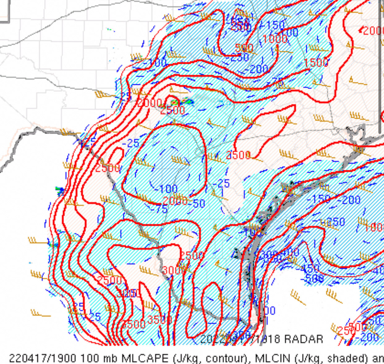
Still some lingering surface based and mixed layer convective inhibition remaining downstream, but that should mostly be eroded by 4 PM. More than enough CAPE/shear for supercells, as evidenced by two ongoing supercells near Fredericksburg.

-
Estimating based on that sounding, TTI is approximately 51.5.
-
Signal for a couple of robust supercells developing over the Texas hill country and dropping toward the San Antonio area this afternoon. Thermodynamic profiles would favor large to very large hail growth. Wind profiles are not particularly favorable for tornadoes, given straight hodographs and minimal low-level SRH. Still, the combination of large CAPE and favorable deep layer shear, would expect at least a few significant hail reports near/just north of San Antonio. Will have to watch and see if the metro area is targeted, before storms weaken due to nocturnal stabilization. Edit: Austin could possibly be impacted as well, especially if there are any left moving hailers, as storms will tend to drop SE to S with time.
-
 Analyzing the lower Mississippi Valley portion of the threat area… Outflow boundary from overnight MCS draped from eastern Arkansas into central Mississippi. Richest low-level moisture is confined to Louisiana, but rapid air mass recovery is underway, thanks to a 50-60 knot low-level jet. Still noting some wind field disruption between the two boundaries, where there is some veer-back-veer signals (particularly over southeastern Arkansas. This could result in mixed storm modes with widespread thunderstorm activity developing this afternoon over eastern Arkansas. Even with some wind field issues, most data shows enlarging 0-3km hodographs and supercell wind profiles. Boundary interaction in this type of setup can be very complex. Do a few storms thread the needle and become intense, long track supercells? Or is it just a blobby mess. I think this is the difference between moderate and high risk I believe the most shot for somewhat more isolated supercell activity will be from Far East Texas into Louisiana and possibly southern Arkansas/western Mississippi. It’s going to be a busy day.
-
It’s also Broyles… but the parameter space is pretty volatile looking. Potent shear, rich low-level moisture, a bit of an EML. It’s not perfect, but it definitely has the potential to produce one or two intense supercells. Some CAMs, including recent HRRR runs show widespread semi discrete supercells blowing up this afternoon near, along and ahead of the cold front. Only concern there would be cell mergers and interactions, but it does seem ominous with locally backed winds near a residual outflow boundary across the AR/LA border area. Storm mode could get messy, but I’d focus the most intense tornado potential over northern LA, southern AR into western MS. We could have a localized outbreak on our hands.
-
Tang is the man
-
Impressive, mature bowing MCS slamming Shreveport right now. Numerous circulations noted up and down the bow in northwestern Louisiana. Will be interesting to see how this system affects the risk tomorrow. Point forecast soundings show a bit of wind field disruption around 700-600mb across southern/eastern Arkansas and vicinity, in the wake of the MCS. It could also leave one or more outflow boundaries as well. I think tomorrow is a complex day with higher end potential, at least on a localized level. The only limiting factor may be a tendency for cells along the cold front to cluster/grow upscale. Similar to several events in recent weeks, not a ton of confidence with warm sector supercells. We may have a better idea after watching this MCS evolve through early morning…
-
Ongoing severe threat with isolated tornadoes across Arkansas… may continue for a few more hours, toward the greater Memphis area. Trying to wrap my head around the local threat in Oklahoma tomorrow. Convection seems obvious near the triple point up near Nebraska/Iowa. Confidence is otherwise growing lower of initiation along the dryline in Kansas, but it’s still possible. The only models remaining with substantial CI in Oklahoma are the Euro and RGEM. FV3 seems a bit more subdued, although it has a tendency to over convect anyway. A few ARW members hint at very isolated CI as well. HRRR, NSSL WRF and 3km NAM all show nothing, despite a minimally capped environment near peak heating. What caught my eye is that the RAP/NAM both show a shortwave crossing across North Texas toward eastern Oklahoma around 21-00z. Given the orientation of the dryline and local climatology, I’d think that at least one storm tries to go up in southwestern/south-central Oklahoma. Not sold on storm intensity or longevity, but it’s a very difficult forecast from a public awareness standpoint. Oh yeah, we’ll probably see some strong/severe convection in North Texas toward the Arklatex well. SREF odds of convective precip, in vicinity of favorable instability: Wednesday is complicated. If early day convection doesn’t lead to a mess, it will be a day to remember. Even if there is ongoing convection (East Texas toward the Arklamiss area), there seems to be good model agreement with a broken line of convection with embedded supercells sweeping across Arkansas and southeastern Missouri in the afternoon. Shear vectors tend to line up more parallel with the boundary there, but some hodograph curvature still supports a tornado risk. Even if it evolves as a total mess of convection, I’d be surprised if there isn’t at least 1-2 long-track and/or intense supercells, somewhere in the AR/MO/MS/W TN vicinity, given the degree of shear and moist low-levels; low LCLs. I think we’re in the midst of one of the more profound multi day early spring stretches, that I can recall, in recent memory.
-
I don’t think it’s a slam dunk that there’s initiation up and down the dryline on Tuesday, but I think there’s a strong possibility that the cap is at least locally breached. Any sustained storms that can form will have the potential to produce very large hail and tornadoes. I can envision a scenario where most areas see nothing, but one or two intense supercells form. The Euro has been very consistent with convective initiation. The NAM doesn’t convect, but point forecast soundings only show minimal capping. It wouldn’t take much modification at all to break the cap and produce a few intense storms, per NAM progs.
-
It’s also changed substantially over the past couple of days. I advise extreme caution when looking at severe weather indicies more than 3-4 days out, especially when they’re *probably* based on a deterministic model, rather than ensembles. It’s also kind of silly to show high risk-equivalent graphics for a week out… A lot can change, but here are my initial thoughts: Monday looks like limited moisture return, especially with northward extent. I’d imagine the greatest threat remains across East Texas/Louisiana. Remember that we’re early in the season and antecedent dry conditions exist. Tuesday may have the greatest apparent threat. Dryline could mix slightly farther east than progged, due to ongoing drought conditions. Maybe a more “classic” April event just east of I-35? Parameter space looks volatile, along with deep shear vectors nearly perpendicular to the dryline. Not overhyping yet, but operational models have shown run-to-run signals for at least a couple of days now. Wednesday diverges in the models, but the threat should shift toward the Mississippi Valley. Wind fields are forecast to become more unidirectional with northward extent, along with less favorable moisture closer to an occluding surface low. Could be yet another threat around AR/LA/MS? Not sold on a farther north threat yet, but it’s still possible.
-
Shear vectors look close to parallel to the boundary once again, but those forecast wind fields are nothing to snooze on. I’d expect a similar outcome to the last event, but possibly a bit more widespread in terms of wind damage. Tornado potential, not much confidence beyond the QLCS threat, but it only takes one. (Remember New Orleans…)
-
At quick glance, it looks similar to last Tuesday’s event. Wind fields support more of a mixed mode/linear event, but that can yield several QLCS tornadoes, along with isolated discrete storms, especially on the southern end of the line and possibly immediately ahead of it.
-
Shear vector orientation, virtually uncapped warm sector and a very moist boundary layer = messy and clustered storm mode. A very sloppy evolution so far, but can’t say it’s that far off from what most convection allowing models suggested.
-
Any reports from that storm? I chased it from Taylorsville to Decatur before bailing. Couldn’t see anything with the terrain and swarm of chasers. Only caught a few brief glimpses of a scuddy wall cloud.
-
Everything is pretty much evolving as expected. The squall line in western Mississippi may be advancing slightly quicker than forecast, but that’s common for these setups. The wildcard was open warm sector development. It’s underway across southern Mississippi and adjacent Louisiana. A couple of cells near/just west of Hattiesburg appear to be in the process of better organizing. This coincides with cloud breaks and 100+ J/kg 0-3km MLCAPE. I’d keep an eye on that area.
-
Good discussion from SPC. I agree that the ceiling is going to come down to how much warm sector activity there is. The parameter space will strongly favor supercells with low-level rotation, given hodograph shape and sizable 0-3km CAPE. The other factor that may limit the outbreak to some degree is that deep layer shear vectors are almost parallel to the boundary, where forcing is stronger. (SW as opposed to more westerly, in higher end events like 4/28/14) The result should be a broken band or two with QLCS circulations and embedded supercell structures. Wind damage with isolated tornadoes can be expected in that regime, while a conditional risk for open sector tornadic supercells will exist as far east as western Alabama later today. Any sustained open sector supercells will have the better potential to be longer lived, in terms of tornado production.
-
Storm mode is getting increasingly clustered, but wind profiles ahead of East Texas tornado warned storms remain very favorable for low level rotation:

-
I’m not sure the cap is very strong. If you look at the 00z and 06z 3km NAM, they both show cellular convection along the Dallas - Round Rock corridor. If anything, it’s more concerning that the NAM is showing more isolated convection, as it’s the case that many of these setups get junky fast with too much convection. That doesn’t seem to be the case here. The only slight limiting factor may be modest low-level lapse rates, due in part to early precipitation. Still, even with 0-3km lapse rates only near 6 C/km, the quality of the boundary layer moisture profile supports large 0-3km MLCAPE, on the order of 100-200 J/kg. This, along with strong wind profiles supports a significant tornado threat As echoed before, this is not exactly a common occurrence for a synoptic severe weather outbreak, this far south. HRRR looks nasty with intense, semi discrete convection. NAM is nasty with a weaker looking broken band of convection within a volatile parameter space. Either scenario isn’t good (if you don’t like damaging thunderstorms).
-
Severe Weather Outbreak 02/16-02/17
Quincy replied to Tallis Rockwell's topic in Central/Western States
Very strong wind fields - 00z MAF (Midland-Odessa) sounding sampled 107 knots of 0-6 km shear. Impressive wind profiles will drive the severe threat through Thursday night. -
Severe Weather Outbreak 02/16-02/17
Quincy replied to Tallis Rockwell's topic in Central/Western States
Doesn’t look like a major outbreak. Thursday probably has the most potential of the two days. Timing has slowed down, trending threat areas farther west. Wednesday looks like mainly a nocturnal threat at this juncture across Texas and possibly parts of Oklahoma. Thursday could be more potent across the lower Mississippi Valley. -
1043 PM SNOW LOGAN AP 42.36N 71.01W 01/29/2022 M23.8 INCH SUFFOLK MA ASOS
-
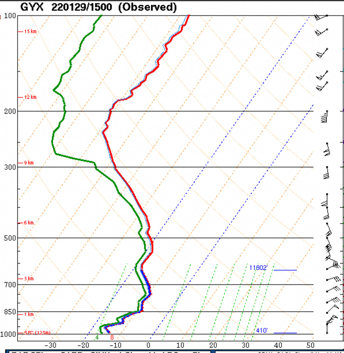
Special sounding from GYX. Not sure if it was posted yet. Epic liquid-to-snow ratios along I-95 FTW:
-
Short term/high res guidance seems to be struggling with banding over eastern Mass - underestimating the strength of the deformation band, but not picking up well on the dryslot on the Cape & Islands. The band may collapse a bit back east, but the PVD-BOS corridor and points just east are going to get absolutely smoked for at least a few more hours. Noting a dryslot of sorts over Tolland County though.
-
Severe Weather event October 23rd-27th 2021
Quincy replied to weatherextreme's topic in Central/Western States
Looks like damaging winds will be the predominant threat, as a robust 50+ knot low-level jet is present across much of Oklahoma. Can’t rule out a QLCS tornado or two, given the degree of low-level shear.